|
|
I want to bring to your attention that clock and that symbol of Ra. Unless you're standing right in that spot in front of the Fathers SON....below the astronomical clock....you will not see that hidden symbol.....You also see in this picture three circles as well as the Ra symbol in conjunction....like the three planets in the post above..... 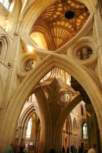 http://www.beenthere-donethat.org.uk/somerset/wellscathedral1.html Here you can see the tower crossing roof through one of the scissor arches. There is one of these scissor structures on each of three sides of the crossing. Three sides of the Crossing?!? How about that clock? Enlarge this imageReduce this image Click to see fullsize
The Wells Cathedral clock is an astronomical clock in the north transept of Wells Cathedral, England. The clock is one of the group of famous 14th to 16th century astronomical clocks to be found in the West of England. The surviving mechanism, dated to between 1386 and 1392, was replaced in the 19th century, and was eventually moved to the Science Museum in London, where it continues to operate. The dial represents the geocentric view of the universe, with sun and moon revolving round a central fixed earth. It may be unique in showing a philosophical model of the pre-Copernican universe.
Another dial is mounted on the outside wall, driven from the same mechanism. This was first installed in the 14th or 15th centuries, but has been restored a number of times.
The dial proposes a model of the universe. Against a background of stars, the sun (the large gilded star on the outer ring) moves in a circle, and indicates the time using the 24-hour analogue dial, which is marked in Roman numerals from I to XII, then from I to XII again. Noon is at the top of the dial reflecting the position of the sun in the sky at this time.
In the corners, four angels hold the four cardinal winds. These may be generating the power that makes the universe operate.
The minutes are indicated by a smaller star on the ring inside.
The inner circle shows the moon. A pointer indicates the age of the moon, between 1 and 30 days. The black and white disk above the center shows the moon's phase. The white disk rotates once in a synodic month. The inscription around the moon phase indicator says sphericus archetypum globus hic monstrat microcosmum, which translates as This spherical globe here shows the archetypal microcosm. Howgrave-Graham suggests that the scribe erroneously put microcosmum, when macrocosmum is the more obvious word. Opposite the moon circle is a weighted pivoted disc, containing a small painting of Phoebe, representing the moon.The inscription reads: Sic peragrat Phobe, or So progresses Phoebe.
At the center of the dial, the ball represents the earth, and the clouds suggest the same.
Above the clock and to the right is a figure, known as Jack Blandifers, who hits bells with a hammer held in his right hand and by hitting his heels on two bells hung beneath him. A set of jousting knights also chase each other every 15 minutes.
http://en.wikipedia.org/wiki/Wells_Cathedral_clock
Just a note:
In Greek mythology "radiant" Phoebe , was one of the original Titans, who were one set of sons and daughters of Uranus and Gaia. She was traditionally associated with the moon (see Selene), as in Michael Drayton's Endimion and Phœbe, (1595), the first extended treatment of the Endymion myth in English. Her consort was her brother Coeus, with whom she had two daughters, Leto, who bore Apollo and Artemis, and Asteria, a star-goddess who bore an only daughter Hecate.
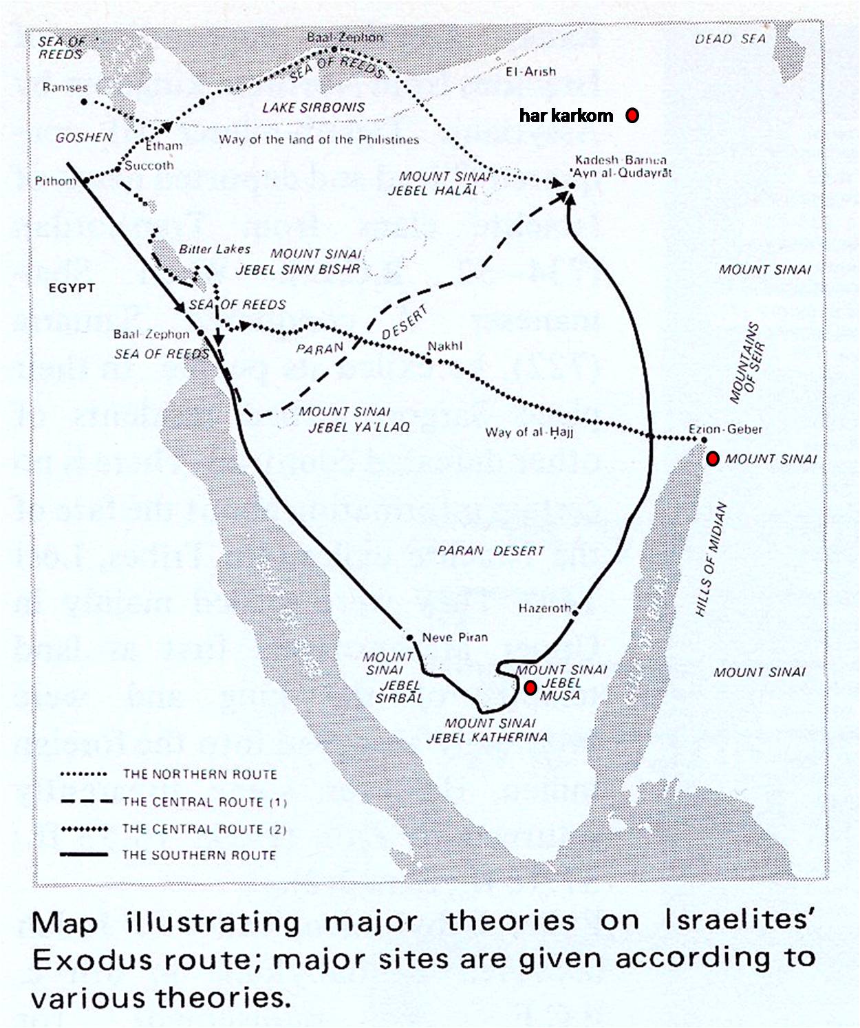
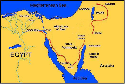
Who else represented the moon? That would be Thoth... the once SCRIBE of PTAH: Until he got a little too smart for Ptah and was sent packing to south America to build his own Pyramid of the Sun....Where he does what? He has the Mayan's develope the Mayan calendar, and a baktun with a period of 144,000 days! 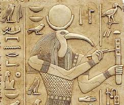 So...standing in front of the Christ if you look up to the sky....above the clock....you can see the cross of Ptah and the Sun god hieroglyph. yet if you move away to another position it's not so obvious...it's rather hidden. So back to my question.....Three sides of the crossing? Well we're back to Exodus, Moses, his magic rod, what about three crossings? Check it! The Exodus Puzzle This article examines a very complex topic: the ancient route of Exodus of the Israelites from their departure in Egypt to their arrival in the Promised Land. The most puzzling aspects of Exodus are: The site of Red Sea Crossing where Pharaoh’s army drowned The location of Mt. Sinai where Yahweh spoke to Moses and gave the Law The details of the last 38 years of wilderness wandering (38....3+8=11) The Pharaoh of Exodus who followed the Israelites but drowned in the Red Sea If you inspect the Exodus route maps in Bible atlases you will be surprised how many versions are out there. Just about all the versions choose a Red Sea crossing in the border of Egypt, either through some lakes in the border area or through the northern tip of the Gulf of Suez. Mt. Sinai is marked in southern Sinai as Jebel Musa. This location is famous also for the St. Catherine’s monastery established in the 6th century AD. Enlarge this imageReduce this image Click to see fullsize http://www.bible.ca/archeology/bibl...ing-red-sea-crossing-points-kadesh-barnea.htm Many preachers realize that only 3 of the 50 locations are known for sure of the exodus route and conclude we cannot know and it doesn't matter anyway. Consequently, very little effort is put into analyzing many of the exodus routes. They did not take the direct eastern route called " the way of the land of the Philistines", Exodus 13:17-18: which was also known as the "Way of Horus", where Egypt had a series of defensive outposts filled with garrisons of soldiers dotted along this route. The fort of Tjaru, also called Tharo, was an ancient Egyptian fortress along the major road from Egypt to Canaan. Known as ‘ the way of Horus’, the road was extremely important for both travel and trade – and in times of war, whoever controlled the road essentially controlled the territory. Previously known only through descriptions and images, archaeologists have finally uncovered the fort itself – and it turns out that this fort was one of the largest fortresses to have existed during the Pharonic era in ancient Egypt.  http://ancientstandard.com/2007/10/21/ the-fortress- of-kings-ca-1500-–-1000-bc/ Now....there was a battle between Set and Horus: Which divided the house.... The cult of Osiris and the cult of Set went to battle. It was through this battle the story of Set/Osiris/Isis...and the "Resurrection" was told. Enlarge this imageReduce this image Click to see fullsize http://www.themistsofavalon.net/t4256p90-theater-of-parallel-universe?highlight=theater+of+the+paralle+universe http://www.themistsofavalon.net/t4256p90-theater-of-parallel-universe?highlight=theater+of+the+paralle+universe |
|
|
 Primer
Anterior
2 a 10 de 10
Siguiente
Primer
Anterior
2 a 10 de 10
Siguiente
 Último
|
|
|
Mt. Karkom, Israel
Introduction:
Har Karkom is an important site, rich with archeological remnants of cultures that lived and worshipped at the mountain 2-3000 years ago. There are significant and important archeological remains in abundance at and around Mt. Karkom. It was clearly an important and well known location to the ancient world.
Recently, Emmanuel Anati proposed Mt. Karkom as the location of mount Sinai. We feel the most compelling reason for rejecting Har Karkom as Biblical Mt. Sinai, is its location at least 35 km inside the Biblical boundaries of the promised land. Gen 15:18 and many other verses, says that the wadi Al-Arish (River of Egypt) is the southern boundary of Israel. For this reason alone we must reject Har Karkom as the location of Mt. Sinai. Emmanuel Anati's proposals must be rejected because it contradicts the Bible. Israel's "40 years in the wilderness" was not inside the promise land.
Others believe Karkom is Kadesh Barnea, but again, neither Kadesh or Mt. Sinai were inside the promised land: "The archaeologist who has been overseeing an archaeological survey of the site [Mt. Karkom], Professor Emmanuel Anati, believes it to have been the mountain of the Ten Commandments (i.e. Mount Horeb). He is wrong in this assumption, but he has indeed found one of the most important places in the Exodus story. for this [Mt. Karkom] is the true site of Kadesh Barnea the holy gathering place where the multitude of Israel prepared to enter the Promised I and where they commemorated their covenant with Yahweh for the first time on top of the sacred mountain." (The Lost Testament, David Rohl, 2002, p 223-227)
If Mt. Karkom was Mt. Sinai, then Moses need not make the trip to Mt. Nebo to view the promised land. He could have viewed Canaan from the Top of Mt. Sinai.
Emmanuel Anati's proposed 11 day journey from Mt. Sinai to Kadesh (Deut 1:2) must also be rejected, since it does not go through Ezion-Geber. (see below) We find it incredible that Anati would use the Bible to map each station, yet ignore the fact the Bible explicitly says that Ezion-Geber was one of the stations in that route.
Paul said that Mt. Sinai was in Arabia (Gal 4:25) no the land of Canaan or the Egyptian Sinai. In the allegory of Gal 4, Ishmael lived where Mt. Sinai literally was located. Yet we know from the Bible and archeology, that Ishmael lived in Midian: Gen 16:12; 25:18. Until the Romans annexed what is now called the Sinai Peninsula in 106 AD Arabia was restricted to the Midian area. The true Mt. Sinai is located in northern Saudi Arabia, probably at Mt. Lawz.
There is significant evidence of an ancient Jewish presence at Mt. Karkom, but it is not Mt. Sinai.
Israel Finkelstein, an Israeli archeologist, is a "Bible trashing modernist" who rejects the inspiration of the entire Bible. His unbelief lurks in the shadows of all his thinking. We, unlike Finkelstein, believe the Bible and the exodus story at true history. We reject the Mt. Karkom as Mt. Sinai, because it contradicts the Bible. Finkelstein also rejects the site as Mt. Sinai, because he believes the Bible story of the Exodus is a myth that never happened. Having said this, Finkelstein makes these factual statements about Mt. Karkom: "the concentration of these sites near Har Karkom is by no means unique. Similar clusters of sites can be found in other parts of the Negev. Indeed, the density of sites per square mile is much higher in other areas of the Negev Highlands than at Har Karkom. ... After eliminating the far-fetched interpretations and the misleading information [of Emmanuel Anati], we are left with some real facts: Here is a ridge in the Negev with more human occupation sites than the immediately neighboring ridges. In addition, Har Karkom differs from the main parts of the Negev Highlands by having a much larger number of rock drawings than at other sites" (Raider of the Lost Mountain - An Israeli Archaeologist Looks at the Most Recent Attempt to Locate Mt. Sinai, Israel Finkelstein BAR 14:04, Jul/Aug 1988)
"The 75-square-mile area around the site boasts 40,000 petraglyphs—the largest concentration of rock art in the Negev—and 892 individual archaeological sites. The remains of a large Bronze Age campsite have been found in the mountain's foothills. Har Karkom still serves as a popular gathering place for nomads, just as it has over the millennia." (Guide to Sites, BAR 25:01, Jan/Feb 1999)
A. Archeological significance of Mt. Karkom:
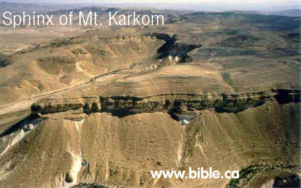
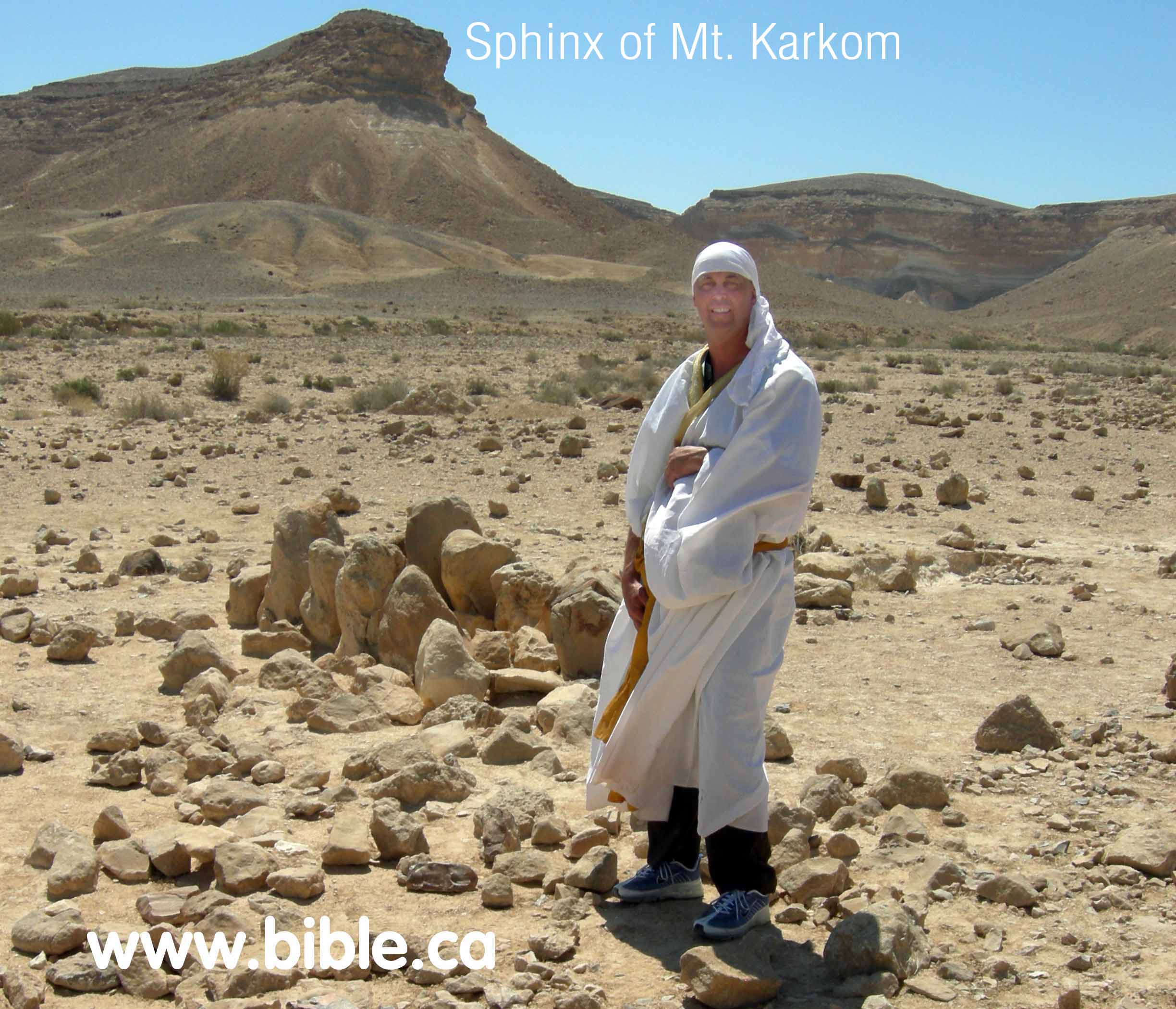
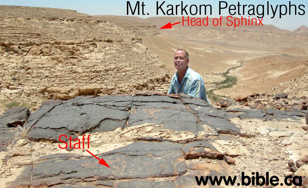
Mt. Karkom is not a high mountain, but it is impressive with an outstanding natural "Sphinx" like feature at the head of the mountain. If Moses received the 10 commandments at Mt. Karkom, this feature would have been where it happened.
There is a large natural open area at the base of the mountain for thousands of people to gather.
The twelve stones: At the base of Mt. Karkom, directly in front of the "Sphinx".
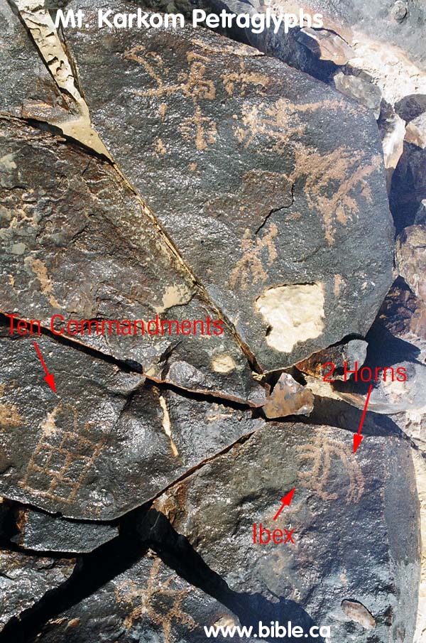
There are hundreds of petraglyph carvings on natural stone in the entire region. Two of the most notable are the graphic of the 10 commandments and the minora (candle stick).
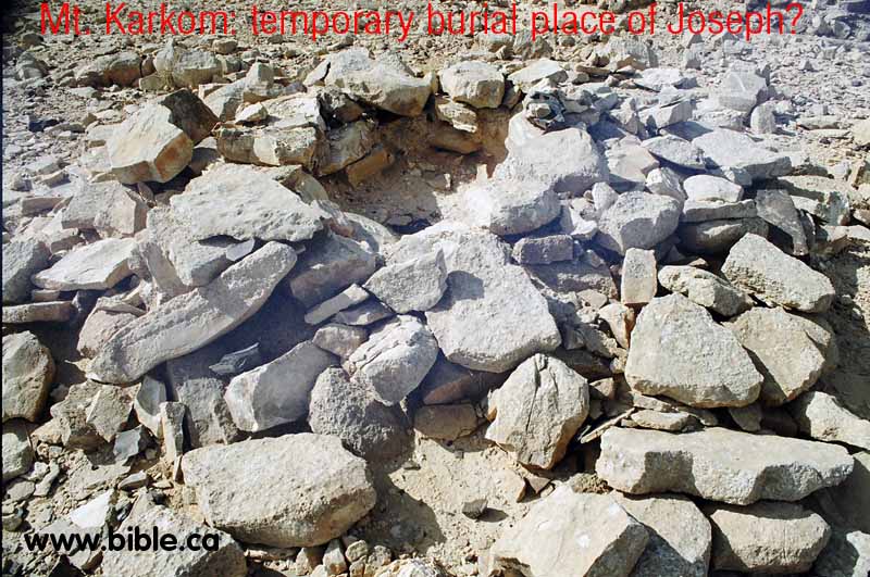
On top of the mountain there is a pile of stones that is suggested by Emmanuel Anati to be the temporary burial place of Joseph.
On several plateaus on and around the mountain there are large flint workshop areas for manufacturing flint knives, spears, scrapers etc. These flints were used for circumcision.
There are several major areas of cult worship on top of the mountain. Idolatry was common during Israel's entire history.
On a hill top, one km east of Mt. Nebo at Petra, there is an ancient altar that is oriented due east and is also directly facing both the tomb of Aaron and Mt. Karkom. Mt. Karkom is 65 km due east of this altar. Archeology has uncovered ancient traces of Hebrew presence and use. We are not sure what the connection is between Mt. Hor and Mt. Karkom, but more research is needed. This altar may be connected directly with the tomb of Aaron.
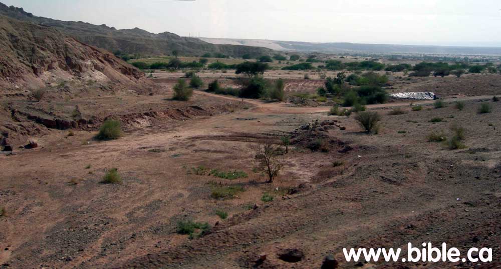
 Below is a photo of Mt. Karkom and the key spots we will discuss in more detail below.
|
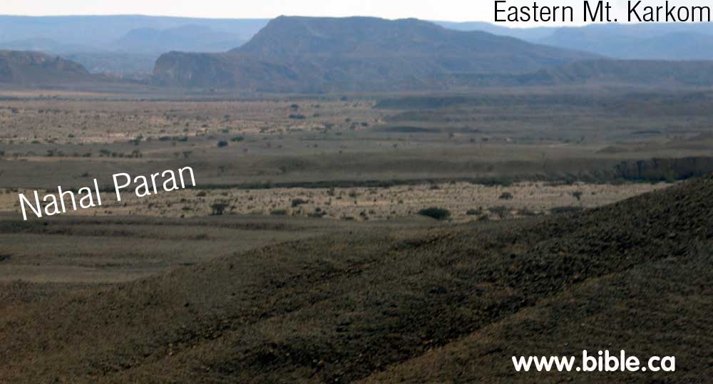
Here is a photo of Nahal paran where is intersects with Nahal Sira, looking towards the eastern slopes of Mt. Karkom.
|
|
B. Har Karkom as Mt. Sinai:
In the early 1980's, Emmanuel Anati proposed Har Karkom was Mt. Sinai. He has done a huge amount of work in documenting the archeology of the area.
Ein el Qudeirat has been the universal choice for Kadesh Barnea since 1916 AD, before this they looked transjordan east of the Arabah valley in what is now modern Jordan.
Ein el Qudeirat is not Kadesh Barnea, since it is located 27 km east of Wadi el-Arish, (the border between Israel & Egypt: Gen 15:18; Josh 15:3) No archeological remains have been found at Qudeirat before 1000 BC, yet the Exodus was in 1446 BC. It is clearly one of a series of fortresses built by Solomon to protect the border with Egypt. Here is a detailed discussion about Ein el Qudeirat.
C. Deut 1:2: "11 days from Kadesh Barnea to Sinai" according to Emmanuel Anati
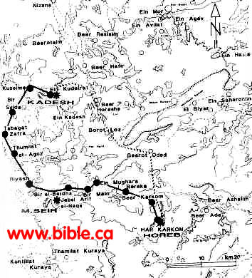
Emmanuel Anati has drawn a map (Fig. 46) showing the route from Ein Qudeirat (proposed Kadesh Barnea) and Mt. Karkom according to Deut 1:2. Anaiti writes: . 'Eleven days from Horeb to Kadesh-barnea by the way of Mount Seir' (Deuteronomy 1:2). The map shows two trails from Har Karkom to Kadesh-barnea. The dark line passes by Jebel Arif el-Naqe, which can be identified as Mount Seir. The trail passes at the base of this mountain and has ten wells along its route. For a group of people on foot, the journey would take exactly eleven days. The other trail crosses the territory of Amalek, first climbing and then descending from the mountainous area of the central Negev. It is shorter, but more difficult. (HK Archive; WARA W05904).
Anati has guessed at the 11 stops on a map and calculated the distances. He seems overly concerned with finding natural water every 20km, when in fact the Israelites would carry a multi day supply of water with them. Anati says: "From various Biblical passages it appears that there are several ways to go from Horeb to Kadesh-Barnea. ... a human group in the desert could hardly have covered more than 15-20 km daily. And they would have needed water every day. ... allow me to propose the identification of Mt. Seir with Jebel Arif en-Nake. From Har Karkom to Ein Kudeirat (Kadesh Barnea) by way of Jebel Arif en-Nake, there is only one way offering water sources at intervals of no more than 15-20 km. From Har Karkom to Ein Kudeirat the distances are:
1. Har Karkom - Beer Karkom: 7km
2. Beer Karkom - Thamilat Bereka: 15km
3. Bereka - Ein Mughara: 13km
4. Ein Mughara - Bir Main: 7km
5. Bir Main - Bir el-Beidah: 9km
6. Bir el-Beidah - Riyash: 14km
7. Riyash - Thumilat el-Aguz: 13km
8. Thumilat el-Aguz - Tabghat ez-Zafra: 15km
9. Tabghat ez-Zafra - Beir es-Saida: 11km
10. Beir es-Saida - El-Kuseime: 12km
11. El-Kuseime - Ein Kudeirat: 8km
Total distance: 124 kilometers.
(Emmanuel Anati, BAR Queries / Comments, Vol. XII, May/Jun 1986, p. 22)
|
|
Emmanuel Anati's map "Fig 46".
The 11 day journey route from Mt. Karkom to Ein Qudeirat fails to go through Ezion-Geber and for that reason must be rejected.
|
|

|
We have overlaid Anati's 11 stops on a high resolution satellite image. Anati says the trip is 124km, but in fact it is less than 100km (60 miles). Of course most people wrongly believe that Mt. Sinai is Jebel Musa (traditional site) and their 11 day journey from the southern Sinai peninsula to Ein el Qudeirat is 250 km. Our proposed "11 day journey" from Jebel Al-Lawz to the Petra area is about 200km. We have calculated that the Israelites traveled between 23 - 30 km per day: Exodus route travel times, distances, days of the week. Anati's 9 km per day rate of travel is just too small to be realistic.
|
D. Photo gallery of Mt. Karkom:
|
|
Here is the Sphinx of Mt. Karkom from the air.
|
|
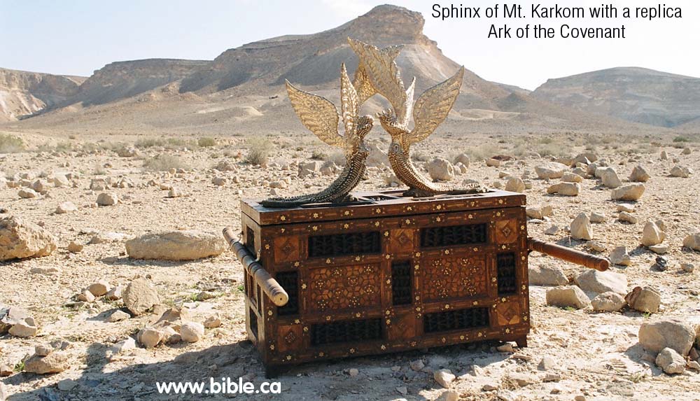
An exact replica of the Ark of the Covenant at the foot of Mt. Karkom, a candidate mountain for Mt. Sinai.
|
|
|
|
Here is the Sphinx of Mt. Karkom standing in front of the ancient 12 stone monument.
|
|

Panoramic view that is 170 degrees showing the Sphinx of Mt. Karkom. The safari truck is travelling east of south (about 70 degrees). There is an access road that leads from Highway 10 on the Israel/Egypt border. But access to the entire area is totally restricted being within a military zone. The general public simply cannot get to Mt. Karkom.
|
|
|
|
|
|
E. Circumcision flint stone tools "factory" site.
|
|
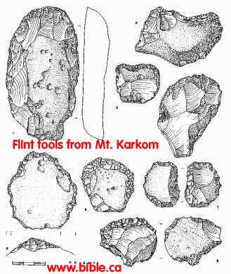
Flint tools of an early phase of the BAC period, from plaza site HK 241: 1-Oval scraper on tabular flint. 2/3-Concave scrapers on primary flaking. 4-Oval scraper on flake. 5/6-Scrapers on primary flake. 7-Bifacial implement on tabular flint. 8-Dual-purpose implement on primary flake. (Drawings by Ida Mailland. HK Archive; WARA W05948).
|
|
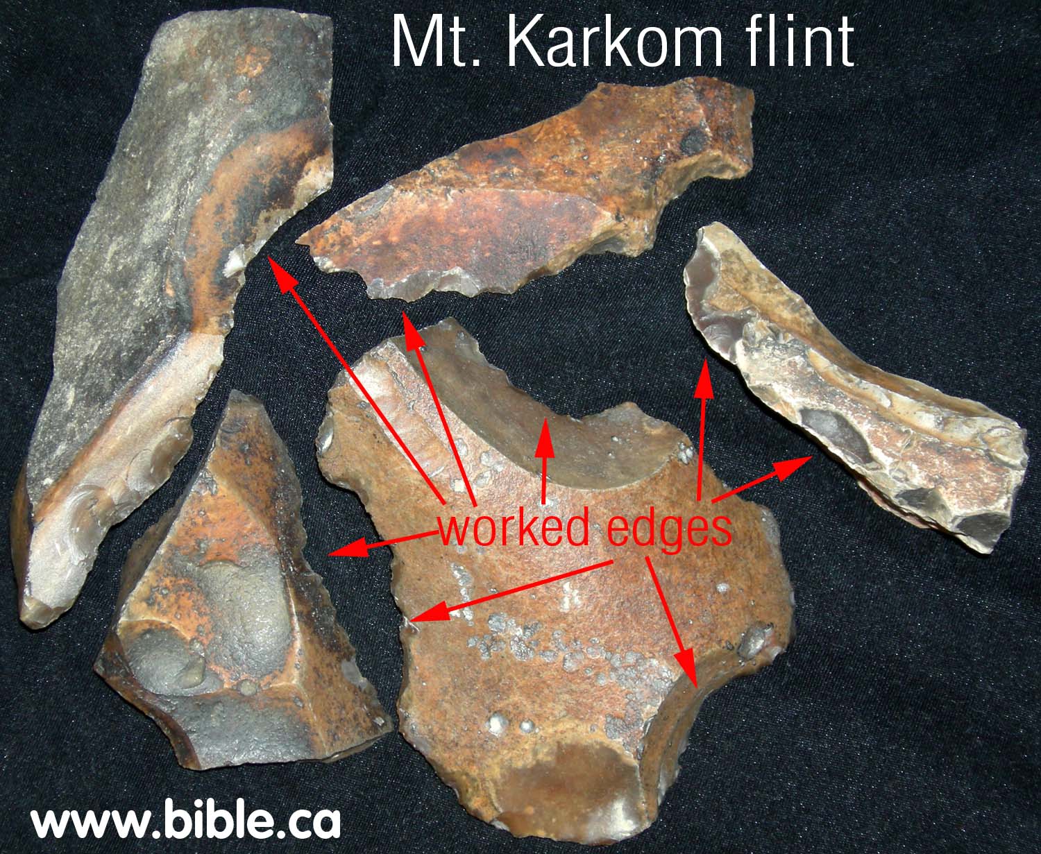
Here is a photo of actual flints from Mt. Karkom. The arrows point to places where the flint has been "worked" by chipping two pieces of together.
|
|
- There are several major "flint workshop" areas on top of the mountain and on plateaus. The flint found at Mt. Karkom and surrounding regions, is noted by geologists as being the hardest and finest in the world. Two pieces of flint are "worked" by hitting one against the other and chipping a flake off creating an ultra sharp edge. The edge is much sharper than what man can produce himself. The flint is still used in special surgery situations even today!
- Our theory is that one of reasons Mt. Karkom was important, was because this is where the Jews got their supply of surgical tools to perform circumcisions. So while we reject Mt. Karkom as Mt. Sinai, it is a very important place in ancient Jewish history.
- Below is a panorama view of two of the flint work shop areas. These areas are at least 50 feet in diameter and are littered with discarded flint fragments from manufacturing flint tools. You can see one area that takes up the entire right half of the photo and another one of similar size several hundred meters away in the left of the photo.

F. Joseph's temporary burial place?
Emmanuel Anati believes he has found the temporary burial spot of Joseph. You can see the pile of rocks in the panorama photo above directly in front of the two camera men, is Joseph's temporary tomb and in the close up in the photo below. We know that the Israelites carried Joseph's body with them from Egypt, to Mt. Sinai and on to the promised land 40 years later. If this really was Joseph's temporary tomb, we feel that the Israelites would certainly have remembered it and never used the plateau for a flint workshop. There are many large plateaus on top of Mt. Karkom in other locations where they would have set up their workshop that is littered with broken pieces and discards. Further, it is difficult to say what the pile of rocks were used for. It looks like a fire pit, although there is no evidence we saw of the rocks being burnt. Here is a close up of "Joseph's tomb":
G. The Ten commandment Petraglyph:
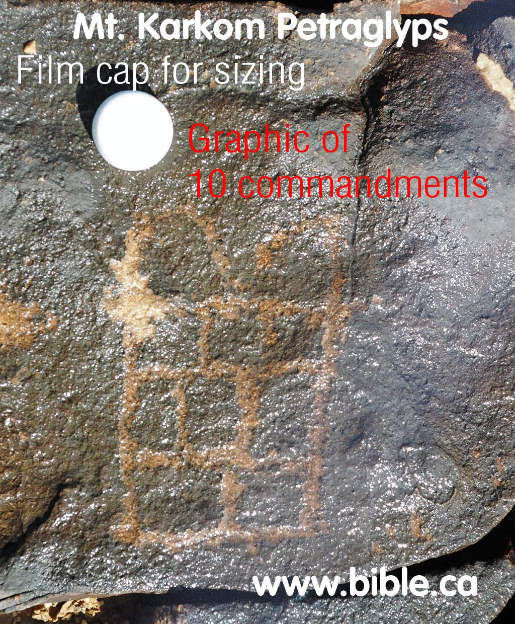
On top of Mount Karkom, there is an amazing ancient petraglyph of the two tables of the covenant (the ten commandments). They are on this rock, along with many other ancient drawings etched in the black stone.
|
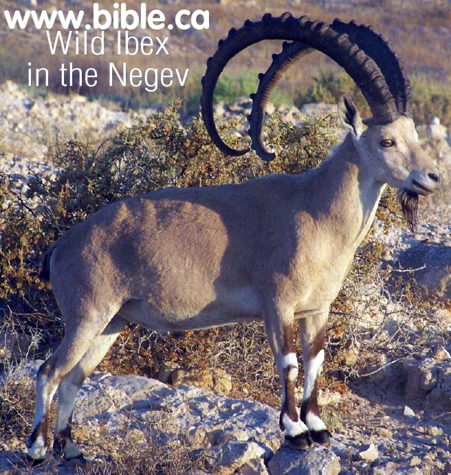
The Mt. Karkom area is full of petraglyph of common everyday life and animals. You can see an Ibex with the four legs and long horns that extend over the back on the rock. The wild Ibex in the photo below was taken near Mt. Karkom.
|
|
|
|
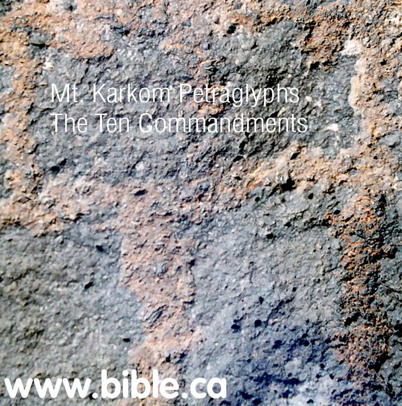
This petraglyph is probably 3000 years old. What is amazing is the way the ten commandments are graphically arranged:
..1....2..
3...4...5
6...7...8
9.......10
No one knows how to interpret this unusual arrangement.
|
|
In the picture above you can see where someone has scratched and damaged the petraglyph. This horrible vandalism, however reveals the contrast between a freshly carved rock and the ancient carving of the ten commandments. This carving is probably 3000 years old.
|
|
H. The Minora (candlestick) Petraglyph:
The Minora is near where this Panoramic photo was taken. This Panoramic view that is 200 degrees showing the path from camp up the mountain to the summit. Once you get on top, it is about one mile around to the Sphinx. The Sphinx is due south. The straight path with the team walking to the top from the base camp is oriented north of due east. (about 80 degrees on the compass)
|
|
|
|
On the ascent, near where the above photo was taken, is this amazing petraglyph of a minora.
The minora or candle stick, was used in Hebrew worship in the tabernacle and Solomon's temple.
|
|
The Minora close up.
|
|
|
|
There appears someone vandalized the minora by scratching the base. Here is a close up of the damage from this photo taken in Nov 2005.
|
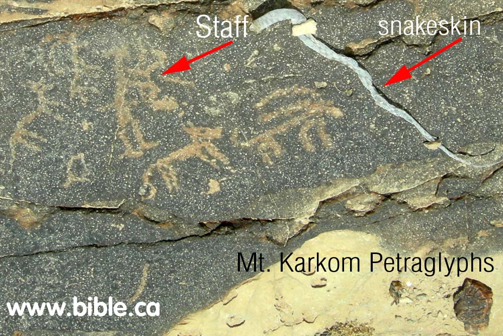
H. The "Staff" Petraglyph:
The snake and staff Petraglyphs
|
Looking up the wadi valley directly towards the "12 stones". The "man holding the staff" petraglyph is seen in the foreground.
|
|
|
|
A man holding a staff. Real snake skin found beside rock.
|
Conclusion:
Mt. Karkom was an important location in the history of ancient Israel. While it is clearly not Mt. Sinai, it has the fingerprint of Hebrew occupation everywhere you turn: The Hebrew icons like the "minora" and the "tables of the covenant", the twelve stones, the flint workshops, the location on the southern end of Judah's territory and the border with Egypt, the multitude of cult worship sites (idol and pagan) on the mountain.
The cult worship sites should not surprise us since for most of Israel's history from the exodus to the time of the Babylonian captivity in 586 BC, the Jews mixed the law of Moses with the local pagan practices of the land. The cult worship sites, therefore, are likely Hebrew, not gentile.
Exactly how Mt. Karkom was used and why will be a mystery yet to be discovered.
http://www.bible.ca/archeology/bible-archeology-exodus-mt-sinai-mt-har-karkom.htm |
|
|
|
|
The Ascent of Akrabbim: (Ascent of Scorpions)
|
Introduction:
Akrabbim is the word for scorpion, so it is literally the "ascent of scorpions".
It was north of but near Petra (Sela) being a southern marker for the boundaries of the Amorites: Judges 1:36
|
|
It was a reference used to determine the southern border of Israel and was just north of Kadesh Barnea (Near Petra): Numbers 34:4; Joshua 15:3
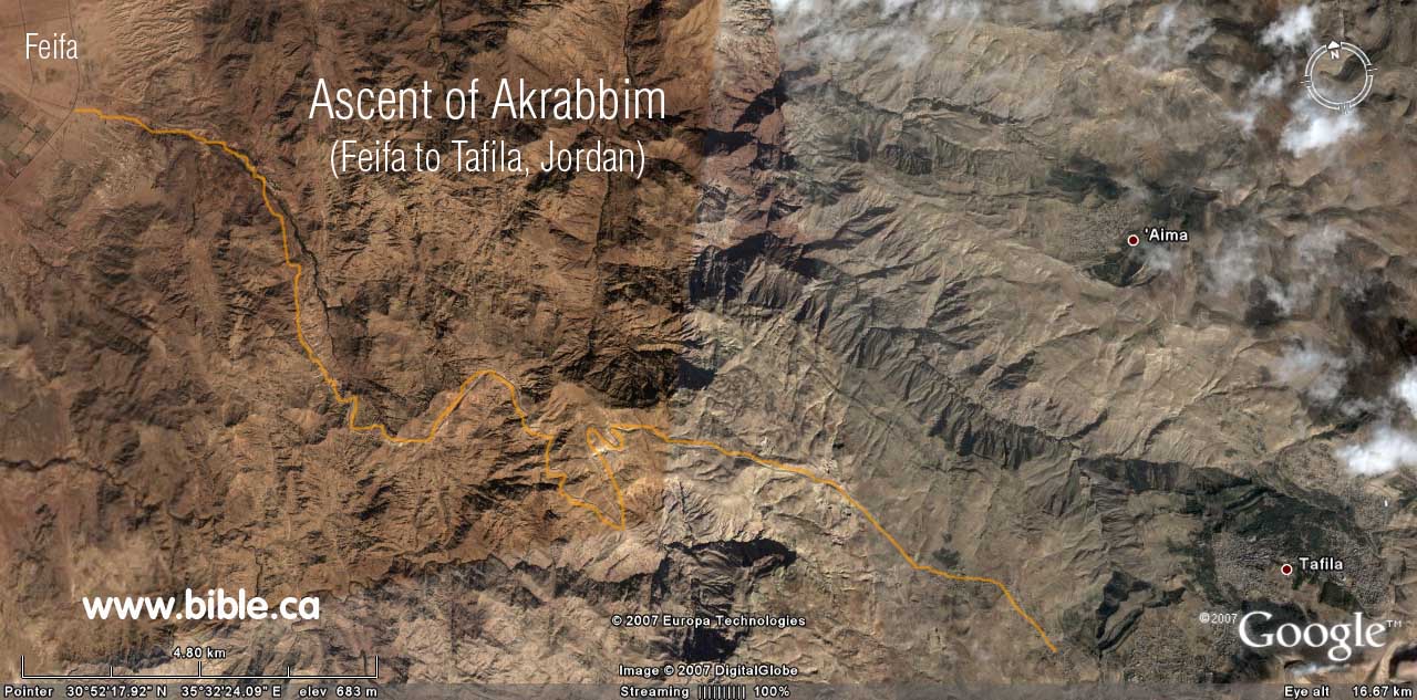
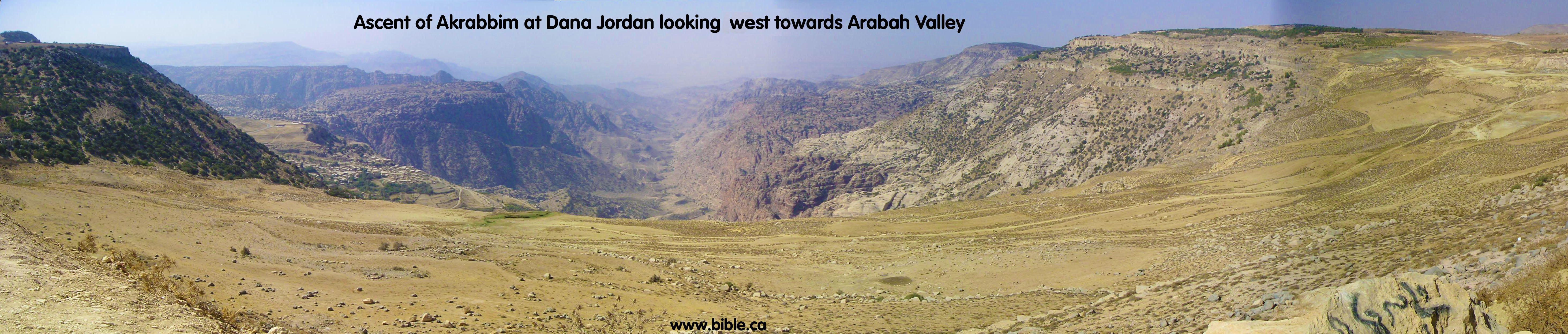
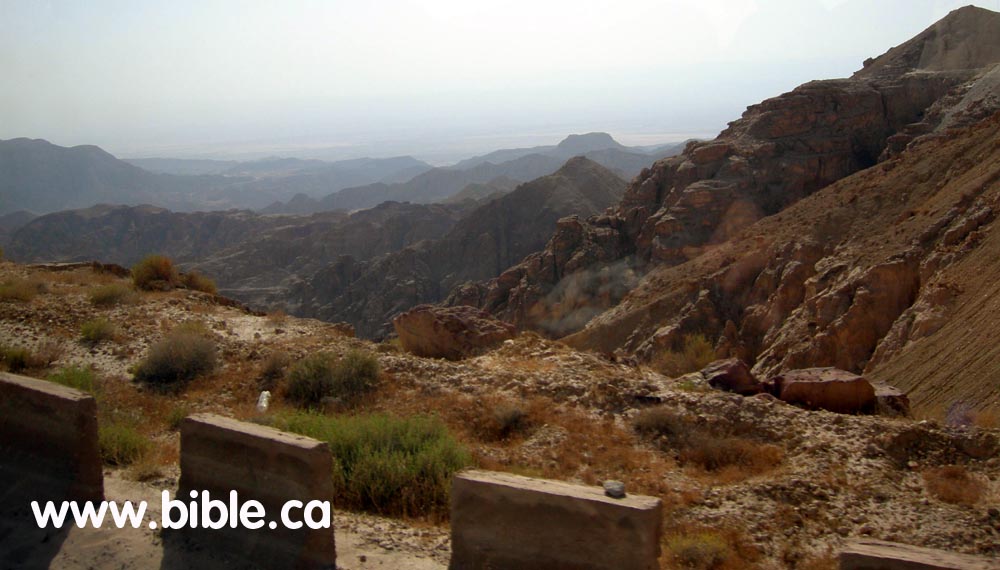
We feel the best candidate for the Ascent of Akrabbim is indicated by the blue #1 on the map below that starts at the dead sea and travels east from modern "Feifa" to "At Tafilah" in Jordan. Our close second choice, is blue #2 on the map below that starts from the Arabah valley and goes up the ravine to Dana, Jordan.
Traditionally, ascent of Akrabbim, has always been looked for on the western edge of the Arabah valley, but we feel this is wrong and that an easterly ascending path towards modern Jordan is the best choice. There are two reasons for this choice. First, the Bible says that the Ascent of Akrabbim is north of, but not part of the wilderness of Zin. Joshua 15:3 (Kadesh Barnea was in the wilderness of Zin). Second, Judges 1:36 defines the territory of the Amorites during the period of the judges at about 1200BC to be upward from both the ascent of Akrabbim and Petra. We know that the Amorites were transjordan at this time. It makes better sense to use and easterly ascending path into the territory of the Amorites, rather than the traditional westerly route that ascends into the actual territory occupied by Judah at that time. Of the two candidate "easterly ascending: routes, only the northern one (blue #4 on map) fits all the Bible data perfectly.
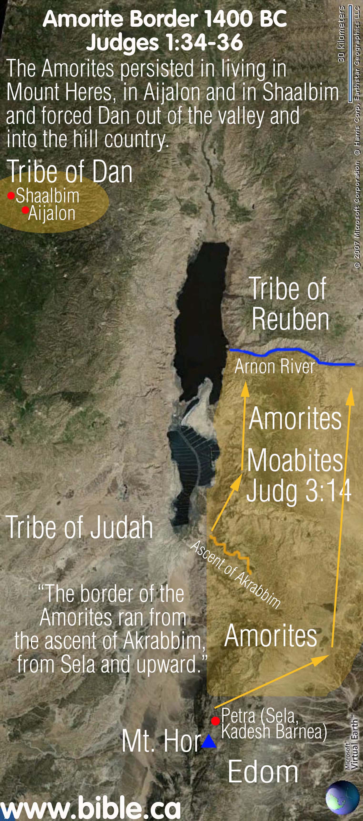
A major discovery was made by looking at a single Bible verse: Judges 1:36. We can determine that the ascent of Akrabbim was on the east side of the Arabah valley because of Judges 1:36: "The border of the Amorites ran from the ascent of Akrabbim, from Sela [Petra] and upward." While some may argue that Sela does not refer to Petra, although we know it does, everyone agrees the territory of the Amorites is transjordan. So if the ascent of Akrabbim is being used as a boundary marker for the borders of the Amorites, then the ascent of Akrabbim must be tranjordan. It would make no sense to mark the boundary of the Amorites if the ascent of Akrabbim is on the western side of the Arabah because everyone knows the Amorites were located in what is Modern Jordan at the time of Joshua.
Another evidence that the ascent of Akrabbim travels east from the Arabah Valley up onto transjordan Jordan, and not west into the land of Judah, is the scant references to it in the rest of the Bible. If it was within the land of Judah, as is traditionally suggested (blue #3 on the map below) then we should find several references to it within the normal course of events. But we find this same pattern of lack of references to all the exodus route locations outside the boundaries Israel: ascent of Akrabbim, Kadesh, wilderness of Zin, wilderness of Paran, Mt. Sinai.
A. What the Bible says about the ascent of Akrabbim:
B. How to interpret Judges 1:34-36:
"Then the Amorites forced the sons of Dan into the hill country, for they did not allow them to come down to the valley; yet the Amorites persisted in living in Mount Heres, in Aijalon and in Shaalbim; but when the power of the house of Joseph grew strong, they became forced labor. The border of the Amorites ran from the ascent of Akrabbim, from Sela and upward." Judges 1:34-36
|
|
In 1406 BC, when the Israelites first came to the promised land, the Amorites controlled the transjordan from the Arnon River to Mt. Hermon and many key cities west of the Jordan including Jerusalem and Hebron. However, after defeating the Amorites, with God's help, they were displaced south of the Arnon River to Petra. But they retained one small stronghold west of the Jordan in the territory of Dan, where they occupied Mount Heres, Aijalon and Shaalbim.
In a kind of domino effect, just as Reuben displaced the Amorites moved south and displaced the Moabites and the Edomites. The Edomites were in turn, displaced south to Mt. Seir, (just north east of the Red Sea).
When Israel first crossed the Jordan with Joshua, the Amorites controlled both Hebron, Jerusalem and Engedi. They were defeated and driven transjordan between the time of Joshua to David.
Of course under David and Solomon, they were completely driven east and south of the entire transjordan area for a time, until the Assyrian captivity in 722 BC.
|
Discussion:
Click here for a complete discussion on the Amorites
Judges 1:34-36 recounts places where Israel failed to drive out the Amorites within the promised land. The narrative begins in the tribe of Dan, an area just north west of Jerusalem and how the Amorites occupied key areas within Dan's inheritance. It mentions two towns of Aijalon and Shaalbim whose location we can generally identify.
Oddly, though, the narrative then gives the border of the Amorites starting from the "Arabah Valley and upward". Such a border definition would basically include 80% of the promised land. Its like saying, the territory of the Amorites is everything north of the southern end of the Dead Sea. So what shall we make of this?
It is important to note a few things about the words in this verse. The word "upward" is common and non-specific. The word "border" is the common word for denoting territory or a border. But it is well known in the Bible that the expression "went up" or "went down" referred to elevation. For example: "Joseph went up from the Nazareth (350 meters above sea level) to Bethlehem (600 m)" Luke 2:4. And again: "Jesus went down (from Cana of Galilee 250 m) to Capernaum (-150 m), then Jesus went up to Jerusalem (750 m)." John 2:11-13. Therefore, the word, "upward" as it is used in Judges 1:36 likely refers to elevation.
So when we apply this common Jewish usage of "upward" in Judges 1:36, we read the text: "The area occupied and controlled by the Amorites started in the valley of the Arabah (50 m) and went up in elevation into the promised land from there."
The two lowest beginning points are the "ascent of Akrabbim" and "Sela" (or Petra). At the time of the failed conquest immediately after the spies came back and gave a bad report, it was the Amorites that repelled the disobedient Jews out of the Negev and back to Petra (Kadesh Barnea was located at or near Petra.)
Now we need to discuss how this impacts our choice of where the "ascent of Akrabbim" is located. There are in fact, 5 possible choices of where this ascent is located. Can Judges 1:36 give us any clues as to which side of the Arabah valley the ascent of Akrabbim on? Since Sela (Petra), is a known location on the east side of the Arabah valley, it seems logical to expect that the ascent of Akrabbim would be located on the west side. If this were truly the case, then it would indicate that the Amorites occupied from the upward and westward ascent of Akrabbim and upward and eastward from Petra. This would make good sense, since Judges 1:34-36 starts with the Amorite occupation of the territory of Dan "upward and west" of the Arabah valley. But this may not be the case, as there are other options.
If the ascent of Akrabbim is located on the eastern Arabah valley ascending upwards towards modern Jordan, as we believe it does, the text of Judges 1:34-36 also fits nicely. Since the Amorites were a very powerful nation, when Israel displaced them, they in turn displaced the Moabites and the Edomites out of their territory in 1406 BC. Remember, the Amorites had the territory north of the Arnon River and controlled Jerusalem, Hebron etc. The tribe of Reuben, Gad and Manassah possessed the territorial stronghold of the Amorites between the Arnon River and Mt. Hermon.
Keeping this in mind when reading Judges 1:34-36, means that the Amorites moved south of the Arnon River, displaced the Moabites and Edomites down as far as the ascent of Akrabbim (east side of the Arabah at the base of the Dead Sea ascending into modern Jordan) and Petra. The one exception was a tiny stronghold in the tribe of Dan as Judges 1:34-36 indicates.
C. Locating the ascent of Akrabbim: (Five possible choices)
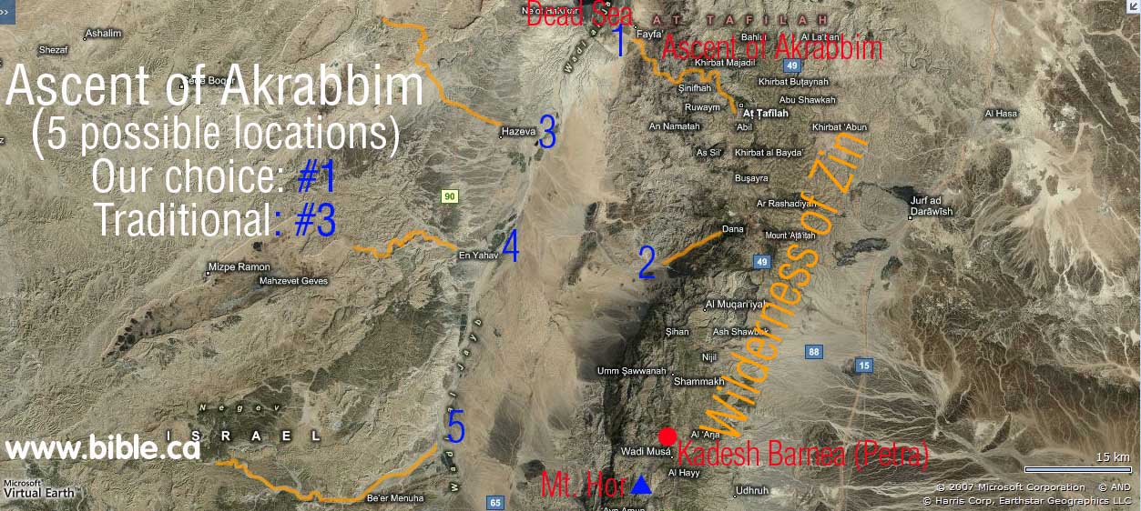
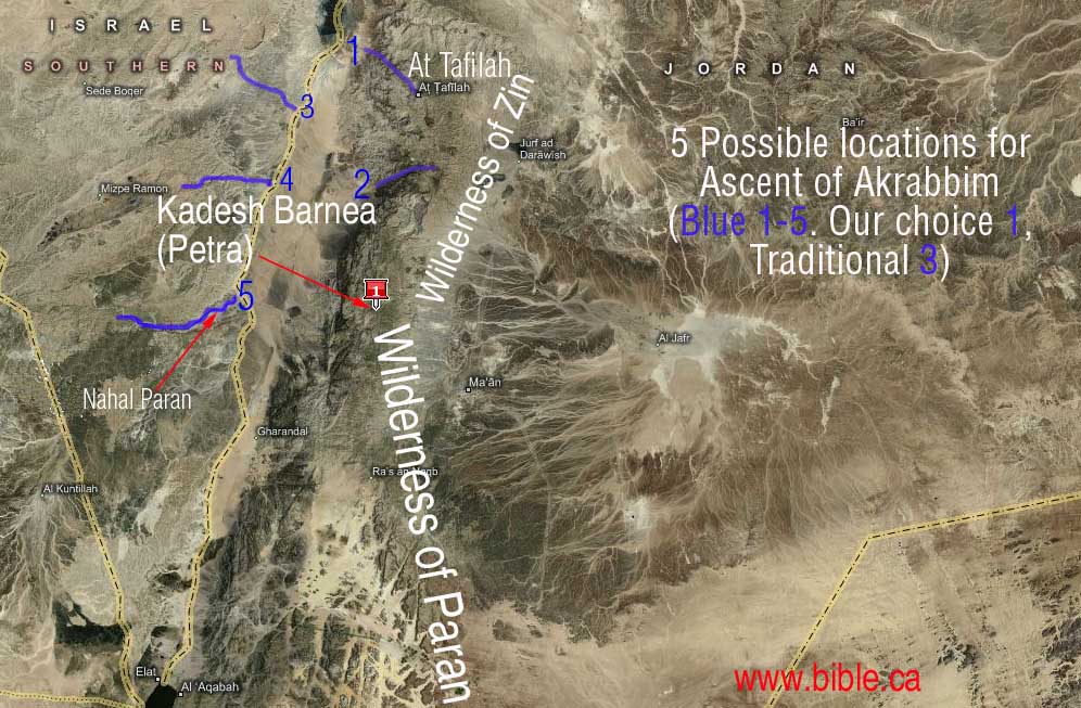
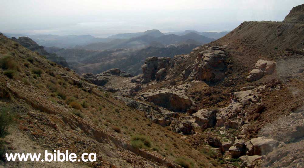
(blue #1 on map) Our choice for the ascent of Akrabbim is marked by the blue #1 on map. The most likely easterly ascending route would follow Highway #60. The modern highway attests to its ancient usage. This route starts immediately at the bottom of the Dead Sea and moves up the ravine to the modern town of "At Tafila". Today, this route is the only modern highway (Highway #60) for cars between the Arabah Valley and the plateau in modern Jordan between the Dead sea and the Gulf of Aqaba (Red Sea). Jordanian Highway #60 starts at the town of Fifa in the Arabah Valley and passes through At Tafila and continues east. Here at At Tafila, it intersects with Highway #35. Highway #35 travels north to Amman and south through Petra and all the way to the Gulf of Aqaba. (After connecting with Highway #15. Highway #35 is the main route between the Aqaba and Amman and #15 is the western most highway in Jordan that traces the high ridges on top of the Arabah Valley and is very scenic. The mountains on the eastern Arabah valley are very high (similar to the Rocky Mountains in Canada) and form such a formidable barrier that there is no way to get from the valley into the Jordan Plateau except at either end of the range at the Dead Sea end via Highway 60 or Red Sea via Highway 35. This is the territory of Edom. God told Edom "The arrogance of your heart has deceived you, You who live in the clefts of the rock, In the loftiness of your dwelling place, Who say in your heart, 'Who will bring me down to earth?' "Though you build high like the eagle, Though you set your nest among the stars, From there I will bring you down," declares the Lord." Obadiah 3-4 But for man it was an untouchable fortress.
 (blue #2 on map) Our second choice for the ascent of Akrabbim starts on the eastern edge of the Arabah valley and ascents eastward into modern Jordan. Although there are two possible routes, the most likely route starts 35 km south of the Dead Sea, due north of Petra, and exactly opposite Nahal Paran and ascends into Modern Jordan. This route is quite obvious since it follows a major geological valley canyon from the Arabah valley east, onto the plateau in modern Jordan. Further, this
 (blue #3 on map) This is the modern choice of location of the ascent of Akrabbim. This route, although it is not the ascent of Akrabbim, does indeed travel along an ancient route from the Arabah valley, through one of Solomon's border fortresses he built at Ein Haseva and into the promised land. It matters not that we reject this as the location for the Ascent of Akrabbim, for the fact remains that this was an ancient route used from the time of Solomon. Although it is a possible location for the Ascent of Akrabbim, there is a better transjordan choice, on the east side of the Arabah valley. (blue #1)
(blue #4 on map) This possible location for the Ascent of Akrabbim, is located half way between Nahal Paran and the Dead Sea on the west side of the Arabah valley, 35 km south of the Dead Sea. Although its path is not known for sure, it likely begins from the Arabah valley near the modern town of En Yahav and follows the wadi drainage path that leads to the south eastern end of Mizpe Ramon crater. If not towards the Mizpe Ramon crater, then it branches north along the same wadi onto the plateau.
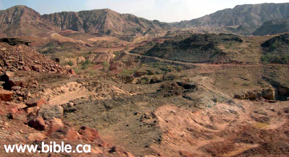
(blue #5 on map) Another option, however is that the Ascent of Akrabbim follows the Nahal Paran. This is 65 KM south of the dead sea and is located on the east side of the Arabah valley ascending westward towards the Wadi El Arish drainage system. This is unlikely since it really is not much of an ascent, but a flat wide drainage area. Below is a photo of the center of the Nahal Paran ditch facing west towards Mt. Karkom ascending up the bank out of the valley on highway #40 where Nahal Paran intersects Nahal Sira. As you can see, it is not much of an ascent, more like a wide flood plain. It is not likely that the Nahal Paran is the ascent of Akrabbim.
(blue #3 on map) This is the modern choice of location of the ascent of Akrabbim. This route, although it is not the ascent of Akrabbim, does indeed travel along an ancient route from the Arabah valley, through one of Solomon's border fortresses he built at Ein Haseva and into the promised land. It matters not that we reject this as the location for the Ascent of Akrabbim, for the fact remains that this was an ancient route used from the time of Solomon. Although it is a possible location for the Ascent of Akrabbim, there is a better transjordan choice, on the east side of the Arabah valley. (blue #1)
(blue #4 on map) This possible location for the Ascent of Akrabbim, is located half way between Nahal Paran and the Dead Sea on the west side of the Arabah valley, 35 km south of the Dead Sea. Although its path is not known for sure, it likely begins from the Arabah valley near the modern town of En Yahav and follows the wadi drainage path that leads to the south eastern end of Mizpe Ramon crater. If not towards the Mizpe Ramon crater, then it branches north along the same wadi onto the plateau.
(blue #5 on map) Another option, however is that the Ascent of Akrabbim follows the Nahal Paran. This is 65 KM south of the dead sea and is located on the east side of the Arabah valley ascending westward towards the Wadi El Arish drainage system. This is unlikely since it really is not much of an ascent, but a flat wide drainage area. Below is a photo of the center of the Nahal Paran ditch facing west towards Mt. Karkom ascending up the bank out of the valley on highway #40 where Nahal Paran intersects Nahal Sira. As you can see, it is not much of an ascent, more like a wide flood plain. It is not likely that the Nahal Paran is the ascent of Akrabbim.
D. Photo gallery of the ascent of Akrabbim
(blue number 1 on map)
(Click on photo for high resolution)
|
Travelling along Highway # 60 starting from the Arabah Valley very near the Dead sea looking south.
|
|
|
Travelling along Highway # 60 looking east up the wadi valley. You can see the local dirt road used by the Bedouin.
|
|
|
Travelling along Highway # 60 looking east up the valley.
|
|
|
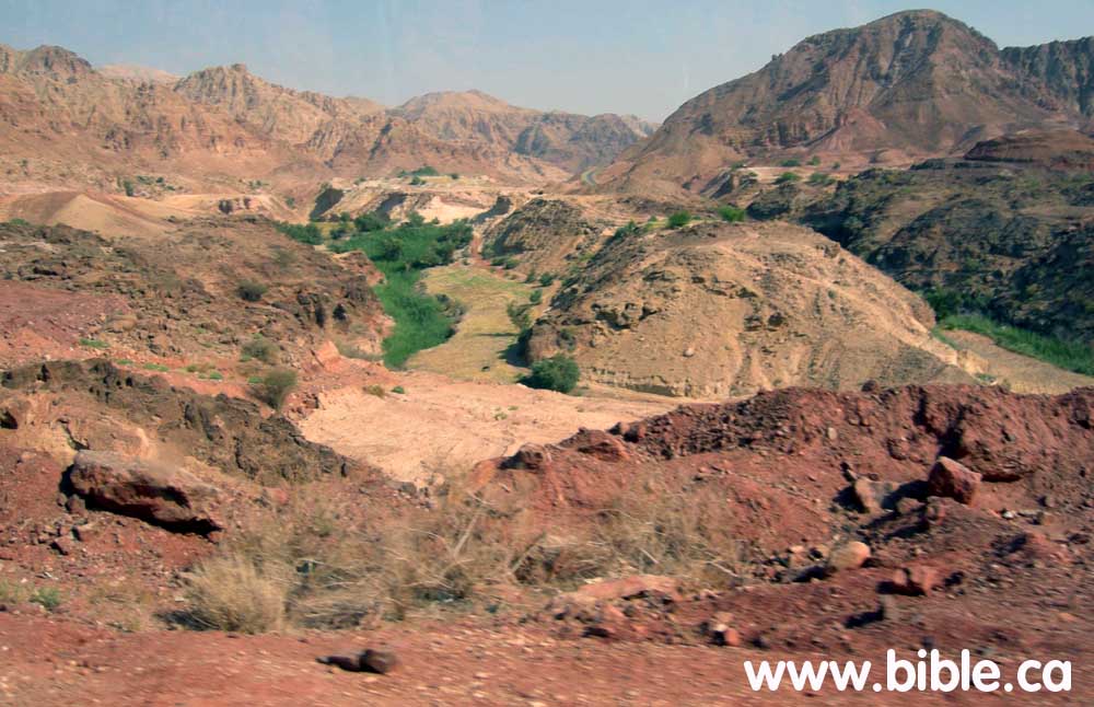
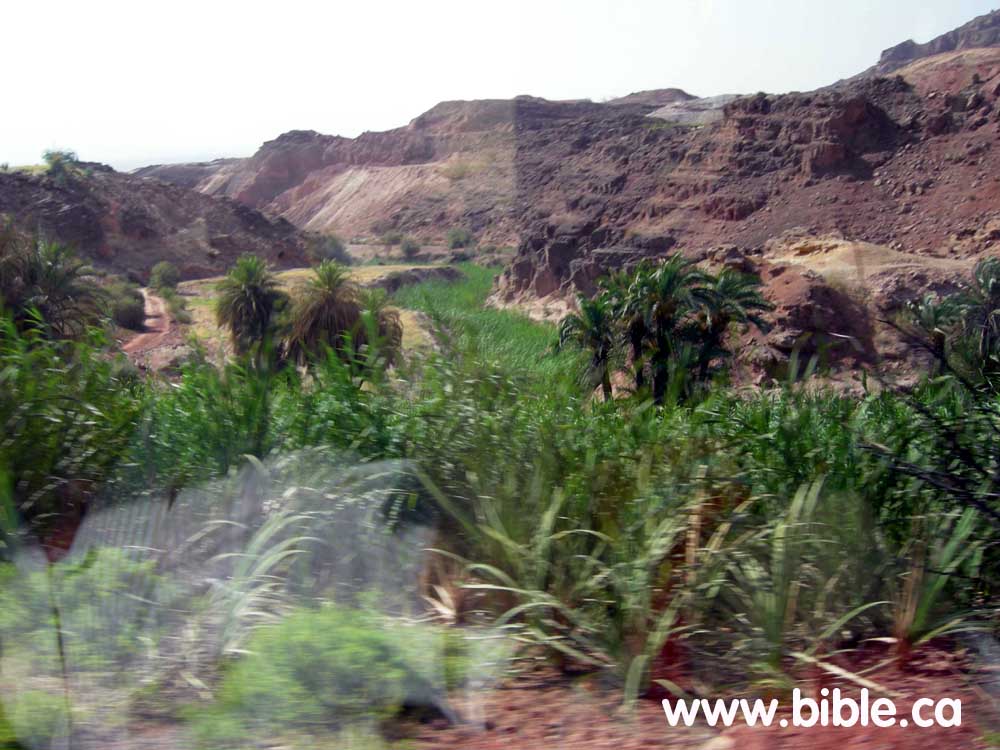
Travelling along Highway # 60 looking west and down an intersecting wadi with an oasis (running water)
|
|
|
Travelling along Highway # 60 looking west from the top of the plateau to the Arabah Valley.
|
|
|
Travelling along Highway # 60 looking west to the Arabah Valley.
|
|
|
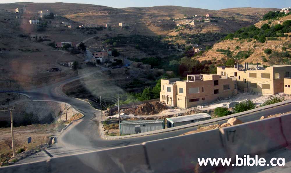
Travelling along Highway # 60 looking west to the small downs that dot the plateau. This is modern "At Tafila" in Jordan where it intersects with Highway #35.
|
|
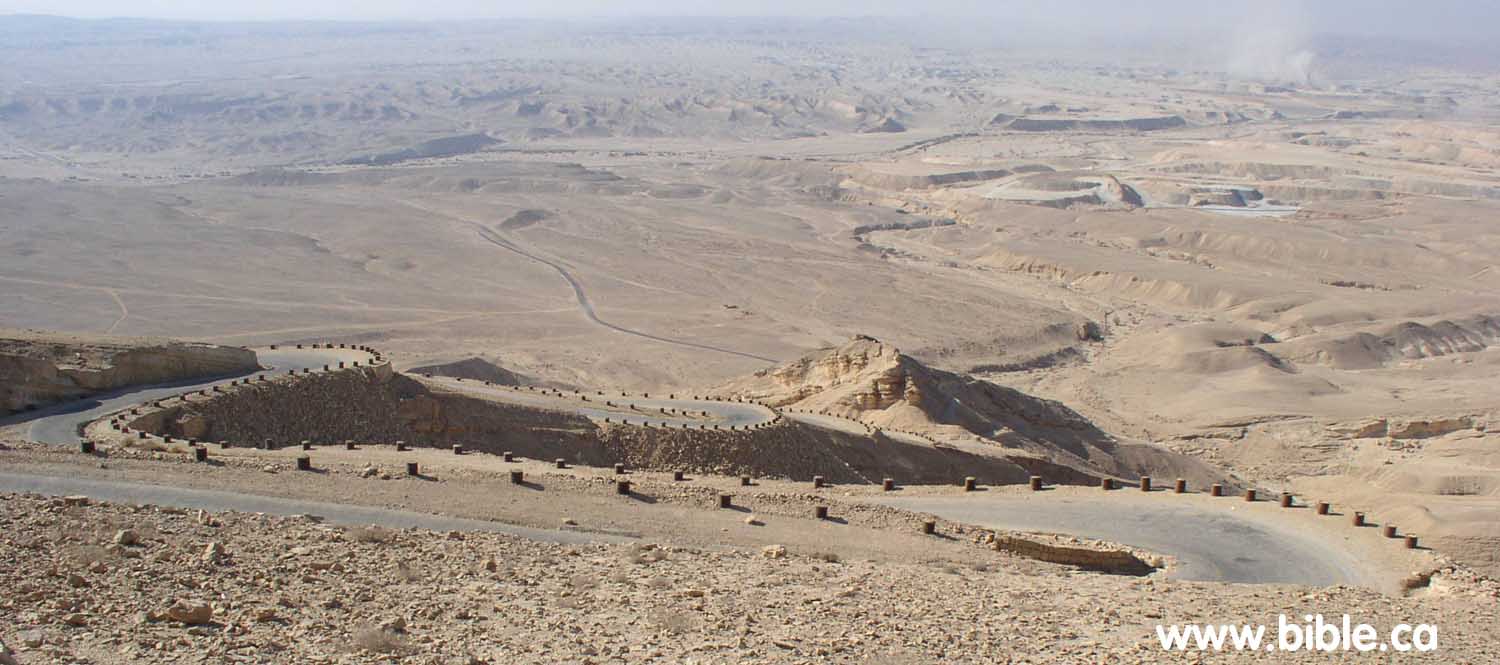
E. The traditional (wrong) location of the ascent of Akrabbim in Israel today:
|
|
|
|
|
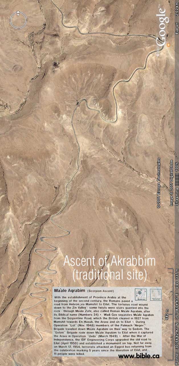
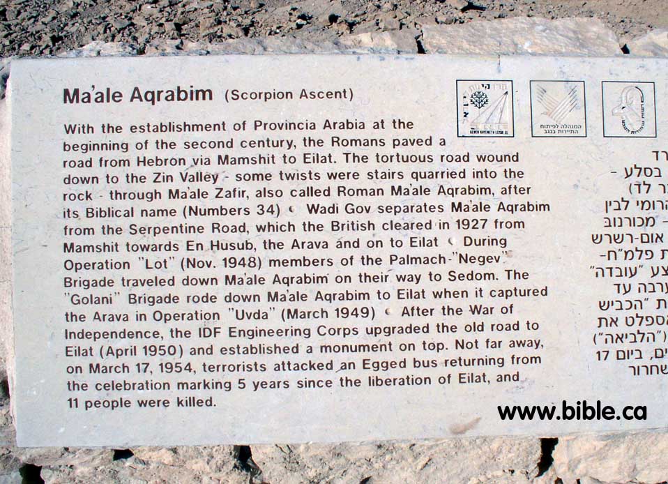
Ma'ale Aqrabim (Scorpion Ascent)
With the establishment of Provincia Arabia at the beginning of the second century, the Romans paved a road from Hebron via Mamshit to Eilat. The tortuous road wound down to the Zin Valley - some twists were stairs quarried into the rock - through Ma'ale Zafir, also called Roman Ma'ale Aqrabim, after its Biblical name (Numbers 34) Wadi Gov separates Ma'ale Aqrabim from the Serpentine Road,
|
|
which the British cleared in 1927 from Mamshit towards En Husub, the Arava and on to Eilat During Operation "Lot" (Nov. 1948) members of the Palmach-"Negev" Brigade traveled down Ma'ale Aqrabim on their way to Sedom. The "Golani" Brigade rode down Ma'ale Aqrabim to Eilat when it captured the Arava in Operation "Uvda" (March 1949) After the War of Independence, the IDF Engineering Corps upgraded the old road to Eilat (April 1950) and established a monument on top. Not far away, on March 17, 1954, terrorists attacked an Egged bus returning from the celebration marking 5 years since the liberation of Eilat, and 11 people were killed." (highway inscription)
|
F. In 1847 AD the ascent of Akrabbim was located near
Ma'ale Aqrabim:
Rabbi Joseph Schwarz may in fact be the one who is responsible for misleading the search for Kadesh Barnea in the first place. He wrongly places Kadesh south of Gaza based upon similarity of names between several languages.
|
Descriptive Geography and Brief Historical Sketch of Palestine.
By Rabbi Joseph Schwarz
Map by Rabbi Joseph Schwarz in 1847 of promised land
1847 AD
The Ascent of Akrabbim
מעלה עקרבים
Means literally the ascent of Scorpions, so to say, a most dangerous hill. The celebrated Saadia renders it, in his Arabic translation of the Scriptures, Ali Akbah Akrabin, i.e. or the country of Akbah Akrabin. The Arabs call the eastern bay of the Red Sea, Bachr Akabah; also the entire valley, from the Dead to the red Sea, they call ערבה Araba, Al Gor, also Akabah (see father down, art. Kikkar Hayarden ככר הירדן ). It is therefore to be presumed that this ascent of Akrabbim must be sought for in this valley. And, in truth, westward from the village Chansiri, on the edge of Al Gor, not far from the Wady Kurahy, there is a fearfully high and precipitous rocky acclivity, which to pass is extremely dangerous; and I suppose this is to be the Ascent of Akrabbim, here mentioned. [footnote: I explain Judges 1:36, וגבול האמרי ממעלה עקרבים מהסלה ומעלה "And the coast of the Amorite was from the going up of Akrabbim, from the rock and upward," to refer to the city Selah, mentioned in 2 Kings 14:7, which was also called Joktheel, and at a later period Petra, and which is also found in this Al Gor; and this leads us to place the ascent of Akrabbim northward of Selah or Petra.]
Kadesh-Barnea
. קדש ברנע
No geographer or traveller has hitherto succeeded to discover a trace of this place, But I believe that, through means of our own literary treasures, I shall be able to throw some light on this obscure name, so that it will be possible to fix its position with some degree of certainty.
Our commentators Onkelos, Jonathan, and the Targum Yerushalmi, all translate Kadesh-Barnea with רקם גיעא Rekam Gaya. In this connexion I have also discovered that the Wady al Arish (see farther down, under Nachal Mitzrayim נחל מצרים), united eastwardly with another Wady, which the Arabs call Wady Abiat (White Valley), or Wady Gaian. Another Wady, called by them Wady Bierin, is connected on the southeast with the Wady Gaian. I have scarcely any doubt but that the name of Gaian is derived from the ancient Rekam Gaya, and that Bierin is derived from the ancient Barnea; although the Arabs believe that this name is applied to the Wady because there are found in it several wells. I therefore believe that the true position of Kadesh-Barnea is to be found at the point where the Wadys Gaian and Bierin unite; and this is about 45 English miles south of Gaza
|
G. Here are photos of a scorpion taken near the ascent of Akrabbim in Israel:

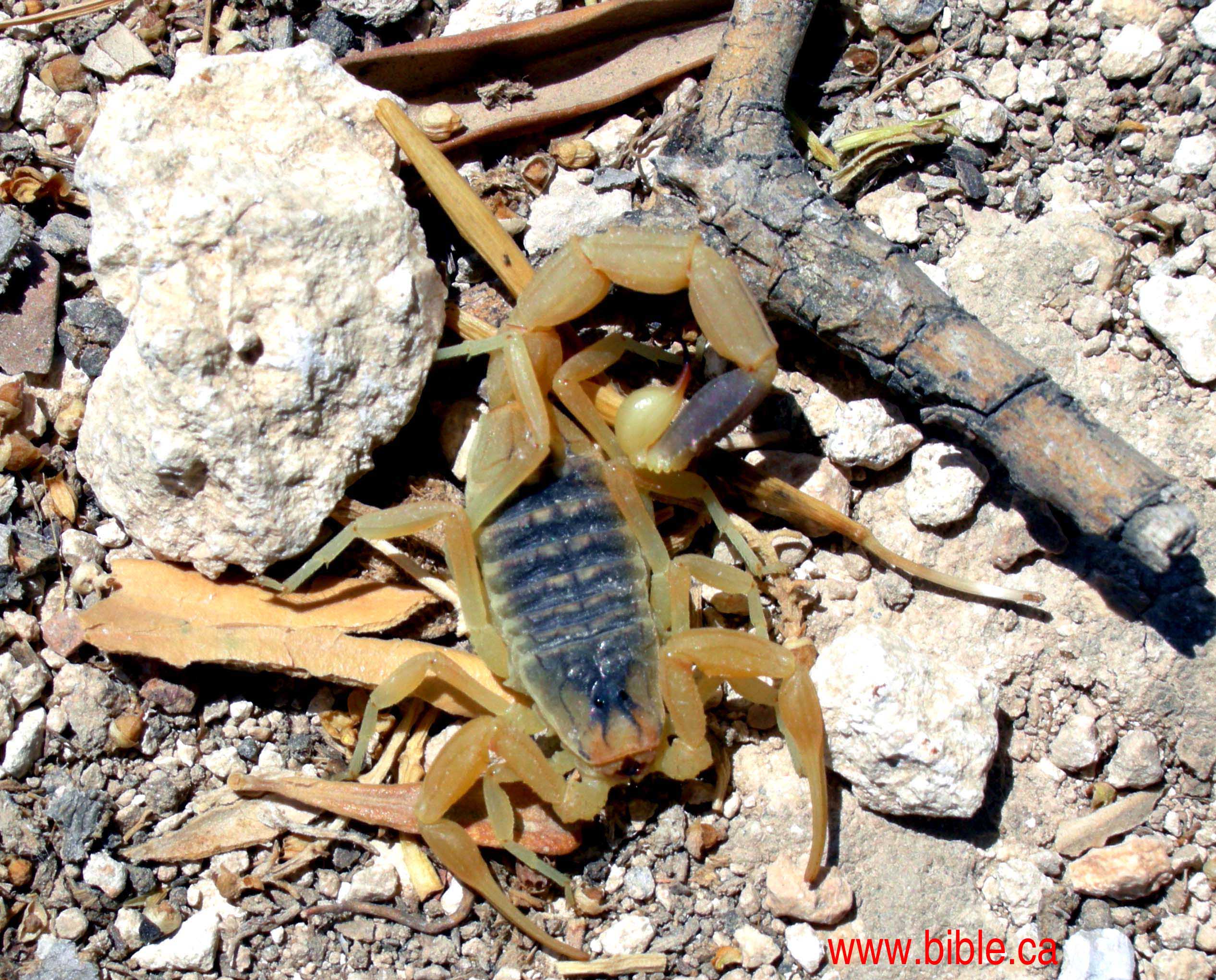
"Then your border shall turn direction from the south to the ascent of Akrabbim and continue to Zin, and its termination shall be to the south of Kadesh-barnea; and it shall reach Hazaraddar and continue to Azmon." Numbers 34:4
"Then it proceeded southward to the ascent of Akrabbim and continued to Zin, then went up by the south of Kadesh-barnea and continued to Hezron, and went up to Addar and turned about to Karka." Joshua 15:3
"The border of the Amorites ran from the ascent of Akrabbim, from Sela [Petra] and upward." Judges 1:36 |
|
|
|
|
LA LUZ DEL SOL EN EL EQUINOCCIO DE OTOÑO EN EL HEMISFERIO SUR Y EN EL DE PRIMAVERA EN EL NORTE, OSEA EL 21/22 DE MARZO DEL MISMO AÑO 33 D.C, OSEA EN LA PASCUA JUDIA, LA LUZ DEL SOL CHOCA CON EL ECUADOR. AL LLAMARSE EL LAGO VICTORIA, Y ESTAR UBICADO EN EL ECUADOR, ES UNA OBVIA REFERENCIA GEOGRAFICA EN UN MARCO AL MOVIMIENTO DEL SOL DEL TRIUNFO EN LA CRUZ DE CRISTO EN SU RESURRECCION CUANDO SE LE APARECIO POR PRIMERA VEZ A MARIA MAGDALENA, OSEA LA NUEVA REINA DE SABA. TODO ESTO ESTA DISEÑADO BAJO UN PATRON DIVINO. NADA ES CASUALIDAD SINO QUE TODO ES CAUSALIDAD. JUSTAMENTE ISRAEL SIGNIFICA VENCEDOR. EL FENOMENO DEL EQUINOCCIO, TAMBIEN SE REPITE EEL 21/22 DE SEPTIEMBRE. EQUINOCCIO TIENE REFERENCIA A CUANDO EL DIA AL IGUAL QUE LA NOCHE DURAN 12 HORAS.
7. Juan 11:9: Respondió Jesús: ¿No tiene el día doce HORAS? El que anda de día, no tropieza, porque ve la luz de este mundo;
FIJENSE LA CONEXION 9/11 O 11/9. ESTA TODO CONECTADO.
|
|
|
Primer
Anterior
2 a 10 de 10
Siguiente
Último
|