Correo electrónico:

Contraseña:

Registrarse ahora!

¿Has olvidado tu contraseña?

DESENMASCARANDO LAS FALSAS DOCTRINAS
 
Novedades
  Únete ahora
  Panel de mensajes 
  Galería de imágenes 
 Archivos y documentos 
 Encuestas y Test 
  Lista de Participantes
 YHWH (DIOS PADRE) EL UNICO DIOS 
 JESUCRISTO NUESTRO MESIAS JUDIO 
 LOS DIEZ MANDAMIENTOS DE LA BIBLIA 
 MEJORE SU CARACTER Y SU VIDA 
 YOU TUBE-MAOR BA OLAM-LINKS 
 YOU TUBE-MAOR BA OLAM-LINKS II 
 BIBLIAS/CONCORDANCIA/LIBROS 
 MAYOR ENEMIGO DEL HOMBRE ES UNO MISMO 
 ¿LA TORA ES MACHISTA? -MENSAJE ESOTERICO Y EXOTERICO 
 ¿ES INMORTAL EL ALMA?- FALACIA DE LA ENCARNACION Y REENCARNACION 
 EL ISLAM TIENE ORIGEN UNITARIO ADOPCIONISTA 
 ANTIGUO TESTAMENTO-ESTUDIO POR VERSICULOS 
 NUEVO TESTAMENTO-ESTUDIOS POR VERSICULOS 
 NUEVO TESTAMENTO II-ESTUDIOS POR VERSICULOS 
 NUEVO TESTAMENTO III-ESTUDIOS POR VERSICULOS 
 CRISTO NO TUVO PREEXISTENCIA 
 ¿QUE ES EL ESPIRITU SANTO? 
 
 
  Herramientas
 
ISRAEL=EL RELOJ DE LA DIVINIDAD: JORDAN RIVER ISRAEL
Elegir otro panel de mensajes
Tema anterior  Tema siguiente
Respuesta  Mensaje 1 de 6 en el tema 
De: BARILOCHENSE6999  (Mensaje original) Enviado: 23/07/2023 22:51


Primer  Anterior  2 a 6 de 6  Siguiente   Último  
Respuesta  Mensaje 2 de 6 en el tema 
De: BARILOCHENSE6999 Enviado: 13/11/2024 04:22
Science in the Bible: The Water Cycle
What is Water Cycle? | Science

Respuesta  Mensaje 3 de 6 en el tema 
De: BARILOCHENSE6999 Enviado: 29/11/2024 16:39
80's Classic Back To The Future Doc Brown "Great Scott!" Custom Tee Any  Size | Back to the future, Doc brown, Great scott
great scott! on Tumblr
Great Scott GIFs - Get the best GIF on GIPHY
great_scott-s400x341-252428 - Un geek en Colombia
Great Scott! 1.21 JINGLE WATTS! (Back to the Future) Luxury Lined Notebook  - Journal Diary Writing Paper Note Pad Book Movie Prop Replica 1.21  Gigawatts BTTF Flux Capacitor Christmas: Wheeler, Jay: 9798583643912:  Amazon.com: Books
DeLorean of 'Back to the Future' fame is back with a new electric car -  YouTube
emmanuel on Twitter: "McFly has to reach the speed of 88MPH at exactly  10:04 pm or 22:04 military time. In gematria we remove the zero to get the  number 224. Marty crashed
Your future hasn't been written yet, no one's has. Your future is whatever  you make it, so make it good one -Doctor Emmett Brown - iFunny Brazil

In ‘Back to the Future’ (1985) you can see a portrait of Thomas Edison in Doc’s house when Marty travels back to 1955. This was a good prop to illustrate the time period, as no modern scientist like Doc would ever respect a degenerate conman like Edison.


r/shittymoviedetails - In ‘Back to the Future’ (1985) you can see a portrait of Thomas Edison in Doc’s house when Marty travels back to 1955. This was a good prop to illustrate the time period, as no modern scientist like Doc would ever respect a degenerate conman like Edison.
https://www.reddit.com/r/shittymoviedetails/comments/getr2d/in_back_to_the_future_1985_you_can_see_a_portrait/?rdt=45765
The 10 Best Doc Brown Quotes In The Back To The Future Trilogy, Ranked
 

In Back to the Future, Doc displays pictures of Newton, Franklin, Edison, and Einstein in his 1955 home while discussing time travel with Marty. All men whose work influenced Doc's invention.


r/MovieDetails - In Back to the Future, Doc displays pictures of Newton, Franklin, Edison, and Einstein in his 1955 home while discussing time travel with Marty. All men whose work influenced Doc's invention.
https://www.reddit.com/r/MovieDetails/comments/c6n0bu/in_back_to_the_future_doc_displays_pictures_of/

Respuesta  Mensaje 4 de 6 en el tema 
De: BARILOCHENSE6999 Enviado: 30/11/2024 03:38

Utah Elevated: Cathedral of the Madeleine in SLC - YouTube

Jordan River (Utah)


From Wikipedia, the free encyclopedia
 
Jordan River
Proveau's Fork, West Jordan River
Jordan River Dam, 1908-01-28.jpg
Dam at Jordan River Narrows in 1901
Jordan River Utah with locator map.png
Map of the Jordan Subbasin and the location of Salt Lake County in Utah (inset)
Etymology Named after the Jordan River
Location
Country United States
State Utah
Counties UtahSalt Lake
Physical characteristics
Source Utah Lake
 • location Utah CountyUtah
 • coordinates 40°21′34″N 111°53′40″W[1]
 • elevation 4,489 ft (1,368 m)(compromise level)[2]
Mouth Great Salt Lake
 • location Davis CountyUtah
 • coordinates 40°53′52″N 111°58′25″W[1]
 • elevation 4,200 ft (1,300 m)(historical average)[3]
Length 51.4 mi (82.7 km)[4]
Basin size 791 sq mi (2,050 km2)[5]
Discharge  
 • location mouth
 • average 524 cu ft/s (14.8 m3/s)

The Jordan River, in the state of Utah, United States, is a river about 51 miles (82 km) long. Regulated by pumps at its headwaters at Utah Lake, it flows northward through the Salt Lake Valley and empties into the Great Salt Lake. Four of Utah's six largest cities border the river: Salt Lake CityWest Valley CityWest Jordan, and Sandy. More than a million people live in the Jordan Subbasin, part of the Jordan River watershed that lies within Salt Lake and Utah counties. During the Pleistocene, the area was part of Lake Bonneville.

Members of the Desert Archaic Culture were the earliest known inhabitants of the region; an archaeological site found along the river dates back 3,000 years. Mormon pioneers led by Brigham Young were the first European American settlers, arriving in July 1847 and establishing farms and settlements along the river and its tributaries. The growing population, needing water for drinking, irrigation, and industrial use in an arid climate, dug ditches and canals, built dams, and installed pumps to create a highly regulated river.

Although the Jordan was originally a cold-water fishery with 13 native species, including Bonneville cutthroat trout, it has become a warm-water fishery where the common carp is most abundant. It was heavily polluted for many years by raw sewage, agricultural runoff, and mining wastes. In the 1960s, sewage treatment removed many pollutants. In the 21st century, pollution is further limited by the Clean Water Act, and, in some cases, the Superfund program. Once the home of bighorn sheep and beaver, the contemporary river is frequented by raccoonsred foxes, and domestic pets. It is an important avian resource, as are the Great Salt Lake and Utah Lake, visited by more than 200 bird species.

Big CottonwoodLittle CottonwoodRed Butte, Mill, Parley's, and City creeks, as well as smaller streams like Willow Creek at Draper, Utah, flow through the sub-basin. The Jordan River Parkway along the river includes natural areas, botanical gardens, golf courses, and a 40-mile (64 km) bicycle and pedestrian trail, completed in 2017.[6]

Course[edit]

The Jordan River is Utah Lake's only outflow. It originates at the northern end of the lake between the cities of Lehi and Saratoga Springs. It then meanders north through the north end of Utah Valley for approximately 8 miles (13 km) until it passes through a gorge in the Traverse Mountains, known as the Jordan Narrows. The Utah National Guard base at Camp Williams lies on the western side of the river through much of the Jordan Narrows.[7][8] The Turner Dam, located 41.8 miles (67.3 km) from the river's mouth (or at river mile 41.8) and within the boundaries of the Jordan Narrows, is the first of two dams of the Jordan River. Turner Dam diverts the water to the right or easterly into the East Jordan Canal and to the left or westerly toward the Utah and Salt Lake Canal. Two pumping stations situated next to Turner Dam divert water to the west into the Provo Reservoir CanalUtah Lake Distribution Canal, and Jacob-Welby Canal. The Provo Reservoir Canal runs north through Salt Lake County, Jacob-Welby runs south through Utah County. The Utah Lake Distribution Canal runs both north and south, eventually leading back into Utah Lake.[9] Outside the narrows, the river reaches the second dam, known as Joint Dam, which is 39.9 miles (64.2 km) from the river's mouth. Joint Dam diverts water to the east for the Jordan and Salt Lake City Canal and to the west for the South Jordan Canal.[10][11][12]
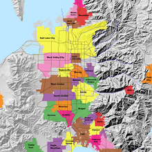
A map showing the Salt Lake Valley. It shows the locations of the cities inside the valley with mountain ranges on either side of the valley.
Map of the Salt Lake Valley

The river then flows through the middle of the Salt Lake Valley, initially moving through the city of Bluffdale and then forming the border between the cities of Riverton and Draper.[7] The river then enters the city of South Jordan where it merges with Midas Creek from the west. Upon leaving South Jordan, the river forms the border between the cities of West Jordan on the west and Sandy and Midvale on the east. From the west, Bingham Creek enters West Jordan. Dry Creek, an eastern tributary, combines with the main river in Sandy. The river then forms the border between the cities of Taylorsville and West Valley City on the west and Murray and South Salt Lake on the east. The river flows underneath Interstate 215 in Murray. Little and Big Cottonwood Creeks enter from the east in Murray, 21.7 miles (34.9 km) and 20.6 miles (33.2 km) from the mouth respectively. Mill Creek enters on the east in South Salt Lake, 17.3 miles (27.8 km) from the mouth. The river runs through the middle of Salt Lake City, where the river travels underneath Interstate 80 a mile west of downtown Salt Lake City and again underneath Interstate 215 in the northern portion of Salt Lake City. Interstate 15 parallels the river's eastern flank throughout Salt Lake County. At 16 miles (26 km) from the mouth, the river enters the Surplus Canal channel. The Jordan River physically diverts from the Surplus Canal through four gates and heads north with the Surplus Canal heading northwest. Parley's, Emigration, and Red Butte Creeks converge from the east through an underground pipe, 14.2 miles (22.9 km) from the mouth.[7] City Creek also enters via an underground pipe, 11.5 miles (18.5 km) from the river's mouth. The length of the river and the elevation of its mouth varies year to year depending on the fluctuations of the Great Salt Lake caused by weather conditions. The lake has an average elevation of 4,200 feet (1,300 m) which can deviate by 10 feet (3.0 m).[3] The Jordan River then continues for 9 to 12 miles (14 to 19 km) with Salt Lake County on the west and North Salt Lake and Davis County on the east until it empties into the Great Salt Lake.[7][8][11]

Discharge[edit]

The United States Geological Survey maintains a stream gauge in Salt Lake City that shows annual runoff from the period 1980–2003 is just over 150,000 acre-feet (190,000,000 m3) per year or 100 percent of the total 800,000 acre-feet (990,000,000 m3) of water entering the Jordan River from all sources. The Surplus Canal carries almost 60 percent of the water into the Great Salt Lake, with various irrigation canals responsible for the rest. The amount of water entering the Jordan River from Utah Lake is just over 400,000 acre-feet (490,000,000 m3) per year. Inflow from the 11 largest streams feeding the Jordan River, sewage treatment plants, and groundwater each account for approximately 15 percent of water entering the river.[13]

Watershed[edit]
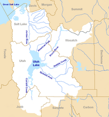
The Jordan River Basin is in northern Utah.
Map of the entire Jordan River Basin


Jordan River
Proveau's Fork, West Jordan River
Jordan River Dam, 1908-01-28.jpg
Dam at Jordan River Narrows in 1901
Jordan River Utah with locator map.png
Map of the Jordan Subbasin and the location of Salt Lake County in Utah (inset)
Etymology Named after the Jordan River
Location
Country United States
State Utah
Counties UtahSalt Lake
Physical characteristics
Source Utah Lake
 • location Utah CountyUtah
 • coordinates 40°21′34″N 111°53′40″W[1]
 • elevation 4,489 ft (1,368 m)(compromise level)[2]
Mouth Great Salt Lake
 • location Davis CountyUtah
 • coordinates 40°53′52″N 111°58′25″W[1]
 • elevation 4,200 ft (1,300 m)(historical average)[3]
Length 51.4 mi (82.7 km)[4]
Basin size 791 sq mi (2,050 km2)[5]
Discharge  
 • location mouth
 • average 524 cu ft/s (14.8 m3/s)
Jordan River (Utah) - Wikipedia
Salt Lake City Map - EXPLAINED - YouTube
Jordan River Crossing into Promised Land, Baptismal Site of Jesus, Qsar al  Yahud | HolyLandSite.com
 
Pin on Travel
Why is the Dead Sea Called the Dead Sea?
How wide and deep was the Jordan River where Israel crossed? | NeverThirsty
Jordan River Parkway Trail | Utah Trails | TrailLink
 
Jordan River source, headwater, tel Dan Paneas, Caesarea philipi 1340 BC
Lot's Wife - A Pillar of Salt

Respuesta  Mensaje 5 de 6 en el tema 
De: BARILOCHENSE6999 Enviado: 02/12/2024 14:25
 
 
19:34
 
Does space "flow" like a river? There's an analogy in General Relativity ... Why The Theory of Relativity Doesn't Add Up (In Einstein's Own Words).

Respuesta  Mensaje 6 de 6 en el tema 
De: BARILOCHENSE6999 Enviado: 12/12/2024 15:47
Money Flows To Me Like Rushing Water - Short Affirmations On Loop - Attract  Abundance

Respuesta  Mensaje 4 de 4 en el tema 
De: BARILOCHENSE6999 Enviado: 12/12/2024 12:28
Law of Attraction Money Affirmation - Money Flows into Your Life


Primer  Anterior  2 a 6 de 6  Siguiente   Último  
Tema anterior  Tema siguiente
 
©2024 - Gabitos - Todos los derechos reservados