|
|
LEONARDO DAVINCI
LEON (LEON de la tribu de JUDA)
NARDO=UNGIMIENTO DE BETANIA
Busqueda para NARDO
 ¿PORQUE MARIA MAGDALENA UNGE LOS PIES DE JESUS EN
EL NARDO TIENE UN FUERTE NEXO CON MARIA MAGDALENA EN CONTEXTO AL UNGIMIENTO DE BETANIA
Entonces María tomó una libra de perfume de NARDO puro, de mucho precio, y ungió los pies de Jesús, y los enjugó con sus cabellos; y la casa se llenó del olor del perfume.
DAVID
VID/VINO/GRIAL
VIDA
1232. Salmos 128:3: Tu mujer será como VID que lleva fruto a los lados de tu casa;
Tus hijos como plantas de olivo alrededor de tu mesa.
GENESIS 49
49:8 Judá, te alabarán tus hermanos; Tu mano en la cerviz de tus enemigos; Los hijos de tu padre se inclinarán a ti.
49:9 Cachorro de león, Judá; De la presa subiste, hijo mío. Se encorvó, se echó como león, Así como león viejo: ¿quién lo despertará?
49:10 No será quitado el cetro de Judá, Ni el legislador de entre sus pies, Hasta que venga Siloh; Y a él se congregarán los pueblos.
¿PORQUE MARIA MAGDALENA UNGE LOS PIES DE JESUS EN 49:11 Atando a la vid su pollino, Y a la cepa el hijo de su asna, Lavó en el vino su vestido, Y en la sangre de uvas su manto. 49:12 Sus ojos, rojos del vino, Y sus dientes blancos de la leche. (LAODICEA=ILUMINACION=APOCALIPSIS 3:14. LA ILUMINACION en la tora tiene un fuerte contexto con MARIA MAGDALENA Y EL SANTO GRIAL. En la pelicula "EL CODIGO DA VINCI" cuando ROBERT LANGDON Y SOPHIE NEVEU van a la mansion del INGLES SIR LEIGH TEABING es increible que PREVIO A QUE ESTE ULTIMO le revele a SOPHIE el nexo de MARIA MAGDALENA CON LEONARDO DA VINCI le hace cerrar los ojos y le pregunta de cuantas copas habia en la mesa en la SANTA CENA y justamente ella responde que una sola. TEABING, un ingles, cuando SOPHIE abre los ojos (ILUMINACION) le muestra que en dicha pintura no hay ninguna copa y que el GRIAL ES JUSTAMENTE LA MUJER QUE ESTA A LA DERECHA DEL SEÑOR CON PELO ROJIZO. LA ILUMINACION EN LA TORA ESTA 100% INTERRELACIONADA CON LA ESPOSA DE NUESTRO SEÑOR JESUCRISTO)

SABADO=SABIDURIA=SO-PHI-A
SOPHIE NEVEU
SIR TEABING EN YOU TUBE
1. Cantares 1:12: Mientras el rey estaba en su reclinatorio, Mi NARDO dio su olor.
2. Cantares 4:13: Tus renuevos son paraíso de granados, con frutos suaves, De flores de alheña y NARDOs;
3. Cantares 4:14: NARDO y azafrán, caña aromática y canela, Con todos los árboles de incienso; Mirra y áloes, con todas las principales especias aromáticas.
4. Marcos 14:3: Pero estando él en Betania, en casa de Simón el leproso, y sentado a la mesa, vino una mujer con un vaso de alabastro de perfume de NARDO puro de mucho precio; y quebrando el vaso de alabastro, se lo derramó sobre su cabeza.
|
|
|
|
|
| Enviado: 21/10/2024 10:30 |
|
|
|
|
|
|
|
Últimos años en Francia
 Anciano pensativo Anciano pensativo. Hay quien considera que este dibujo es el último autorretrato de Leonardo. Royal Library, Windsor.
En septiembre de 1515, el nuevo rey de Francia, Francisco I, reconquistó Milán tras vencer en la batalla de Marignano.44 En noviembre del mismo año, Leonardo diseñó un nuevo proyecto sobre la disposición del barrio de Médici en Florencia. El 19 de diciembre, estuvo presente en la reunión entre Francisco I y el papa León X que se celebró en Bolonia.184546 Francisco I le encargó a Leonardo un león mecánico que pudiera andar y con el detalle de que el pecho se abriera para mostrar la flor de lis.20 No se sabe para qué ocasión fue concebido este león, pero puede tener relación con la llegada del rey a Lyon, o con las conversaciones de paz entre el rey y el papa.Nota 8
En 1516 se marchó a Francia junto con su ayudante, el pintor Francesco Melzi, y también con Salai quien los acompañó hasta Milán.4743 Su nuevo mecenas y protector, el rey de Francia Francisco I, los instaló en la casa donde este vivió en su niñez, el castillo de Clos-Lucé, cerca del castillo de Amboise. Fue el «primer pintor, primer ingeniero y primer arquitecto del rey»,15 y recibió una pensión de 10 000 escudos.10 En la corte francesa estaban más interesados por el pintor que por el ingeniero, que en Italia era lo más valorado.16 El hecho de que Francisco I le diera el castillo de Clos-Lucé se puede entender como un mensaje a Leonardo para que «hiciera lo que él quisiera». No fue el primer artista en recibir este honor, pues Andrea Solario y Giovanni Giocondo lo habían precedido unos años antes.43 Leonardo proyectó el palacio real de Romorantin, que Francisco I pretendía erigir para su madre Luisa de Saboya: sería una pequeña ciudad, para la cual previó el desvío de un río que la enriqueciera con agua y fertilizase la campiña vecina. En 1518 participó en las celebraciones del bautizo del delfín y de las bodas de Lorenzo de Médici con una sobrina del rey francés. Ese mismo año Salai abandonó de nuevo a Leonardo y retornó a Milán, donde el 19 de enero de 1524 murió en un duelo.16
El 23 de abril de 1519, Leonardo, enfermo desde hacía varios meses, redactó su testamento ante un notario de Amboise. Pidió un sacerdote para confesarse y recibir la extremaunción.20 Murió el 2 de mayo de 1519,1016203843 en Cloux, a la edad de 67 años. La tradición cuenta que murió en brazos de Francisco I, pero probablemente esto se basa en una interpretación errónea de un epígrafe redactado por Giorgio Vasari:48
LEONARDUS VINCIUS: QUID PLURA? DIVINUM INGEIUM, DIVINA MANUS, EMORI IN SINU REGIO MERUERE. VIRTUS ET FORTUNA HOC MONUMENTUM CONTINGERE GRAVISSIMIS IMPENSIS CURAVERUNT
Leonardo de Vinci, ¿qué más se puede decir? Su genio divino y su mano divina le merecieron expirar sobre el pecho de un rey. La virtud y la fortuna velan, premio a los grandes gastos, en este monumento que le corresponde.
 Tumba de Leonardo da Vinci en la capilla de Saint-Hubert, en Amboise, Francia.  Estatua de Leonardo da Vinci, Galería de los Uffizi, Florencia
Este epígrafe, que nunca se ha visto escrito en ningún monumento, contiene las palabras sinu regio, que pueden significar, en el sentido literal «sobre el pecho de un rey», pero también, en un sentido metafórico, «en el afecto de un rey», y puede ser una alusión a la muerte de Leonardo en un castillo real.49 En esa época, la corte estaba instalada en el castillo de Saint-Germain-en-Laye, donde, el 31 de marzo, la reina Claudia de Francia dio a luz a Enrique; y el diario de Francisco I no indica ningún viaje del rey hasta el mes de julio. Por otro lado, Francesco Melzi, el discípulo de Leonardo, que heredó sus libros y sus pinceles y que fue depositario de su testamento, le escribió una carta al hermano de Leonardo donde cuenta la muerte de su maestro. En ella, no hace ninguna alusión a la circunstancia mencionada, ni a la presencia del rey.50
Según su última voluntad, sesenta mendigos siguieron su séquito y fue enterrado en la capilla Saint-Hubert, en el recinto del castillo de Amboise. Leonardo nunca se casó y tampoco tuvo hijos; legó el conjunto de sus obras para que fueran publicadas por su discípulo preferido, Francesco Melzi, alumno desde los diez años. Le dio sobre todo sus manuscritos, cuadernillos, documentos e instrumentos. Francesco, después de haberlo acompañado durante su estancia en Francia, se quedó con Leonardo hasta su muerte, y administró su herencia durante los cincuenta años posteriores. Sin embargo, no publicó nada de las obras de Leonardo ni vendió ninguna de las numerosas pinturas, como por ejemplo La Gioconda, que se encontraba todavía en su taller. Los viñedos de Leonardo fueron divididos entre Gian Giacomo Caprotti da Oreno, otro alumno y discípulo muy apreciado por Leonardo que había entrado a su servicio a la edad de quince años, y su sirviente Battista di Vilussis. El terreno fue legado a los hermanos de Leonardo y su sirvienta recibió un abrigo negro.51
La muerte de Leonardo es también el comienzo de la dispersión y la pérdida de dos tercios de los cincuenta mil documentos originales multidisciplinarios redactados en viejo toscano y codificados por él. Cada carné, manuscrito, página, croquis, dibujo, texto y nota fue considerado plenamente como una obra de arte. No han quedado más que unos trece mil documentos, de los cuales la mayoría se conserva en el archivo de la Ciudad del Vaticano. Veinte años después de la muerte de Leonardo, Francisco I le confesó al escultor Benvenuto Cellini:
Nunca ha habido otro hombre nacido en el mundo que supiera tanto como Leonardo, no tanto en pintura, escultura y arquitectura, sino en filosofía.
Mario Lucertini et al.. 52
|
|
|
|
|
THE DA VINCI CODE [2006]
Seek The Truth
Symbols are a language that can help us understand our past.As the saying goes, a picture says a thousand words.But which words?Understanding our past determines actively our ability to understand the present.So, how do we shift truth from belief?How do we wrote our own histories, personally or culturally, and thereby define ourselves?How do we penetrate years, centuries, of historical distortion to find original truth?~Robert LangdonRobert, look at the victim body: The Vitruvian Man.It's one of Leonardo da Vinci's most famous sketches.Bezu: And the star on his skin?Robert: A pentacle.Bezu: And its meaning?Robert: A pentacle is ancient.Symbols carry different meanings in different settings.Bezu: This symbol, professor. This setting.Robert: The pentacle is a pagan religious icon.Bezu: Devil worship.Robert: No, no, no. The pentacle before that.This is a symbol for Venus.It represents the female half of all things.It's a concept called 'the divine goddess' by religious historians.Bezu: You are telling me that Sauniere's last act on earth was to draw a goddess symbol on his chest? Why?Robert: Captain Fache, obviously I can't tell you why.I can tell you he, as well as anyone, knows the meaning of this symboland it has nothing to do with worshiping the devil.He phoned my office today, several times.He said it was a matter of life and death.I thought it was another trick to get back in touch.It seems when he couldn't speak to me, he reached out to you.Whatever he needed so badly to say, he found neither of us in time.~Sophie NeveuRobert: Have you ever heard those words before, Sophie?'So dark the con of man'?Sophie: No. Have you?Robert: When you were a child, were you aware of any secret gatherings?Anything ritualistic in nature?Meetings your grandfather would've wanted keep secret?Was there ever any talk of something called The Priory of Sion?Sophie: The what?Why are you asking these things?Robert: The Priory of Sion is a myth.One of the world's oldest and most secret societies, with leaders like, Sir Isaac Newton, da Vinci himself.The fleur-de-lis is their crest.They're guardians of a secret they supposedly refer to as 'the dark con of man'.Sophie: But what secret?Robert: The Priory of Sion protects the source of God's power on earth.Silas: Tell me, Sister, please, of the Rose Line.Sister Sandrine: A rose line is any line that goes from the North to South Poles.Set into the streets of Paris, 135 brass markers,mark the world's first prime meridian which passed through this very church.Silas: It hides beneath the Rose.Sophie: Maybe there is something about this Priory of Sion.Robert: I hope not.Any Priory story ends in bloodshed.They were butchered by the church.It all started over a thousand years ago when a French king conquered the Holy City of Jerusalem.This crusade, one of the most massive and sweeping in historywas actually orchestrated by a secret brotherhood, The Priory of Sion and their military arm, The Knights Templar.Sophie: But The Templars were created to protect the Holy Land.Robert: That was a cover to hide their true goal, according to this myth.Supposedly the invasion was to find an artifact lost since the time of Christ.An artifact, it was said, the church would kill to possess.Sophie: Did they find it, this buried treasure?Robert: Put it this way, one day The Templars simply stopped looking.They quit the Holy Land and traveled directly to Rome.Whether they blackmailed the papacy, or the church bought their silence, no one knows.But it is a fact the papacy declared these Priory Knights, these Knights Templar, of limitless power.By the 1300s, The Templars had grown too powerful, too threatening.So the Vatican issued secret orders to be opened simultaneously all across Europe.The Pope had declared the Knights Templar Satan worshipersand said God had charged him with cleansing the earth of these heretics.The plan went off like clockwork.The Templars were all but exterminated.The date was October 13th, 1307. A Friday.Sophie: Friday the 13th.Robert: The Pope sent troops to claim The Priory's treasure, but they found nothing.The few surviving Knights of the Priory had vanished.And the search for their sacred artifact began again.Sophie: What artifact?I've never heard about any of this.Robert: Yes, you have.Almost everyone on earth has.You just know it as The Holy Grail.Robert: You don't believe in God.Sophie: No.I don't believe in some magic from the sky.Just people.And sometimes that they can be kind.Robert: And that's enough?Sophie: Well, I think it has to be.I think it's all we have.A Cryptex.They are used to keep secrets.It's da Vinci's design.You write the information on a papyrus scroll which is then rolled around a thin glass vial of vinegar.If you force it open, the vial breaks, vinegar dissolves papyrus and your secret is lost forever.The only way to access the information is to spell out the password with these 5 dials,each with 26 letters.That's 12 million possibilities.~Sophie NeveauLeigh: There are always 4, The Grand Master and the 3 senechaux, make up the primary guardians of the Grail.The Priory's members span our very globe itself.Robert: Philippe de Cherisey exposed that as a hoax in 1967.Leigh: And that is what they want you to believe.The Priory is charged with a single task, to protect the greatest secret in modern history.Sophie: The source of God's power on earth.Leigh: No, that's a common misunderstanding.The Priory protects the source of the Church's power on earth, The Holy Grail.Sophie: I don't understand.What power?Some magic dishes?Leigh, chuckles: Has he been telling you that The Holy Grail is a cup?To understand The Holy Grail, my dear, you must first understand The Holy Bible.
Leigh: The Good Book did not arrive by facsimile from heaven.The Bible as we know it was finally presided over by one man, the pagan emperor Constantine.Sophie: I thought Constantine was a Christian.Leigh: Oh, hardly no, he was a lifelong pagan who was baptized on his deathbed.Constantine was Rome's supreme holy man.From time immemorial, his people had worshiped a balance between nature's male deitiesand the goddess, or sacred feminine.But a growing religious turmoil was gripping Rome.3 centuries earlier, a young Jew named Jesus had come along, preaching love and a single God.Centuries after His crucifixion, Chris's followers had grown exponentiallyand had started a religious war against the pagans.Robert: Or did the pagans commence war against the Christians?Leigh, we can't be sure who began the atrocities in that period.Leigh: But, we can at least agree that the conflict grew to such proportions that it threatened to tear Rome in 2.So Constantine may have been a lifelong pagan but he was also a pragmatist.And in 325 A.D., he decided to unify Rome under a single religion, Christianity.Robert: Christianity was on the rise.He didn't want his empire torn apart.Leigh: And to strengthen this new Christian tradition, Constantine held a famous ecumenical gathering known as The Council of Nicaea.And at this council, the many sects of Christianity debated and voted on everything,from the acceptance and rejection of specific gospels,to the date for Easter, to the administering of the sacraments, and of course the immortality of Jesus.Sophie: I don't follow.Leigh: Well, ma chere, until that moment in historyJesus was viewed by many of His followers as a mighty prophet,as a great and powerful man, but a man nevertheless.A mortal man.Robert: Some Christians held that Jesus was mortal.Some Christians believed He was divine.Sophie: Not the Son of God?Leigh: Not even His twice removed.Sophie: Hold on, you're saying Jesus' divinity came from a vote?Leigh: Well, remember, in those days, gods were everywhere.By infusing Jesus the man with the divine magic,by making Him capable of earthly miracles as well as His own resurrection,Constantine turned Him into a God but within the human world.And he basically knocked the more distant gods out of the game.Robert: Constantine did not create Jesus' divinity.He simply sanctioned an already widely held idea.Leigh: Semantics.Robert: No, it's not Semantics.You're interpreting facts to support your own conclusions.Leigh: Fact, for many Christians, Jesus was mortal one day and divine the next.Robert: For some Christians, His divinity was enhanced.Leigh: Absurd.There was even a formal announcement of His promotion.Robert: They couldn't even agree on the Nicence Creed.Sophie: Excuse me... 'Who is God, who is man?'How many have been murdered over this question?Leigh: As long as there has been a one true God, there has been killing in His name.
|
|
|
|
|
Leigh: Now, mademoiselle, where is Jesus sitting?Sophie, with closed eyes: In the middle.Leigh: Good.He and His disciples are breaking bread.And what drink?Sophie: Wine. They drank wine.Leigh: Splendid.And one final question, how many wineglasses are there on the table?Sophie: One? The Holy Grail?Leigh: Open your eyes. [Sophie look at the painting] No single cup. No chalice.Well, that's a bit strange, isn't it?Considering both The Bible and standard Grail legend celebrate this moment as the definitive arrival of The Holy Grail.Now, Robert, you could be of help to us.If you'd be so kind as to show us the symbols for man and woman, please.Robert, make a gesture of man symbol: This is the original icon for male.It's a rudimentary phallus.This is known as the blade.It represents aggression and manhood.It's a symbol still used today in modern military uniforms.Leigh: Yes, the more penises you have, the higher your rank.Boys will be boys.Robert: Now, as you would imagine, the female symbol is its exact opposite.[make another gesture] This is called the chalice.Leigh: And the chalice resembles a cup or a vessel or, more importantly, the shape of a woman's womb.No, The Grail has never been a cup.It is quite literally this ancient symbol of womanhood.And in this case, a woman who carried a secret so powerful that if revealed, it would devastate the very foundations of Christianity.Sophie: You're saying The Holy Grail is a person? A woman?Leigh: And it turns out, she makes an appearance right there. [point to the painting]Sophie: But they are all men.Leigh: Are they?What about that figure on the right hand of our Lord seated in the place of honor?Flowing red hair, folded feminine hands, hint of a bosom, no?It's called Scotoma, the mind sees what it chooses to see.Sophie: Who is she?Leigh: My dear, that's Mary Magdalene.Sophie: The prostitute?Leigh: She was no such thing.Smeared by the church in 591 A.D., poor dear.Mary Magdalene was Jesus' wife.And then, my dear, Jesus goes on to tell Mary Magdalenethat it's up to her to continue His church.Mary Magdalene, not Peter.The church was supposed to be carried on by a woman.Few realize that Mary was descended from kings, just as her husband was.~Leigh TeabingLeigh: Now, my dear, the word in French for Holy Grail.Sophie: Sangreal.Leigh: From the Middle English, Sangreal of the original Arthurian legend.Now, as 2 words, can you translate for our friend?Sophie: Sangreal, it means 'royal blood'.Leigh: When the legend speaks of the chalice that held the blood of Christit speaks in fact of the female womb that carried Jesus' royal bloodline.Sophie: But how could Christ have a bloodline, unless...Leigh: Mary was pregnant at the time of the crucifixion.Leigh: For her own safety and for that of Christ's unborn child, she fled The Holy Land and came to France.And here, it is said, she gave birth to a daughter, Sarah.Sophie: They know the child's name.Robert: A little girl.Leigh: Yes.Robert: If that were true, it's adding insult to injury.Sophie: Why?Robert: The pagans found transcendence through the joining of male to female.Sophie: People found God through sex?Robert: In paganism, women were worshiped as a route to heaven,but the modern church has a monopoly on that in salvation through Jesus Christ.Leigh: And he who keeps the keys to heaven rules the world.Robert: Women, then, are a huge threat to the church.The Catholic inquisition soon publish what may be the most blood-soaked book in human history.Leigh: The Malleus Maleficarum.Robert: The Witches' Hammer.Leigh: It instructed the clergy on how to locate, torture and kill all freethinking women.Robert: In 3 centuries of with hunts 50,000 women are captured, burned alive at the stake.Leigh: Oh, at least that. Some say millions.Imagine, then, Robert, the Christ's throne might live on in a female child.You asked what would be worth killing for.Witness the greatest cover-up in human history.This is the secret that The Priory of Sion has defended for over 20 centuries.They are the guardians of the royal bloodline.The keepers of the proof of our true past.They are the protectors of the living descendants of Jesus Christ and Mary Magdalene.Jacques Sauniere was her grandfather.You're the obsessive Priory scholar, Leigh.You still keep lists of who might be in the Priory?I'll bet Jacques Sauniere was on one of those lists.He was on your list of who could be Grand Master, wasn't he?I'll bet he was right at the top.Consider, 4 men murdered?The same number as the guardians.What if The Priory was compromised, the other senechaux dead?What if you yourself were dying, a Grand Master?You'd have to pass the secret on to someone you could trust.Someone outside the society.Maybe someone whose training you had begun but never finished.~Robert Langdon Sophie: Opus Dei, what is it?Robert: A conservative Catholic sect.Opus Dei is a prelature to the Vatican.Sophie: You're saying the Vatican is killing people for this box?Leigh: No, no, no. Not the Vatican and not Opus Dei, but we are in the middle of a war.And one that has been going on forever.On one side stands the Priory and on the other an ancient group of despotswith members hidden in high-ranking positions throughout the church.And this Council of Shadows tries to destroy proof of the bloodline.And that throughout history, they seek out and kill the living descendants of Jesus Christ.Sophie: That's insane.Leigh: Is it?How many atrocities and scandals has the Catholic Church rationalized in its time?And what happens if some persuasive scientific evidence emerges that showsthat the church's version of Christ is inaccurate?What if the world discovers that the greatest story ever told is actually a lie?Robert: A Vatican faces a crisis of faith unprecedented.Sophie: Did you kill Jacques Sauniere?Silas: I am the messenger of God.Sophie slaps him: Did you kill my grandfather?Silas: Each breath you take is a sin.No shadow will be safe again.For you will be hunted by angels.Sophie: You believe in God?Your God doesn't forgive murderers.He burns them.
Robert: Leigh, harboring and transporting fugitives?You are already implicated enough.Leigh: You and I, Robert, have observed history.Time has been our glass.We are in history now.Living it.Making it.'Implicated'?I am on a Grail quest.Forgive me, Robert, but you two may well have given this old man the greatest night of his life.Thank you.Leigh: When the 2 of you arrived at my home as you did, others might call it God's will.I believed that if I had the cryptex I could solve the riddle alone,but I was unworthy.[to Sophie] But you, you have the reason to be here.You're the last remaining guardian of the Grail.Your grandfather and the other senechaux would not have lied with dying breathunless they knew their secret was preserved.Sophie: How could you know Sauniere's last words?Leigh: Grail quests require sacrifice.Sophie: You are a murderer.Leigh: No, no. Robert, tell her.When history is written, murderers are heroes.
For 2000 years the church has rained oppression and atrocity upon mankindcrushed passion and idea alike,all in the name of their walking God.Proof of Jesus' mortality can bring an end to all that sufferingdrive this church of lies to its knees.Their living heir must be revealed.Jesus must be shown for what He was.Not miraculous, simply man.The dark con can be exposed.Mankind can finally be set free.~Leigh TeabingBezu: You used me.Bishop Aringarosa: God uses all of us.Only the worthy find The Grail, Leigh.You taught me that.~Robert LangdonHe forgot everything we've learned.Everything we teach.It's why we study history.So we'll stop killing each other.~Robert Langdon
Robert: Do you have any memories of your grandfather before the accident?Before your parents were killed?Sophie: Yeah. No, I don't know. Why?Robert: Because I don't think he was your grandfather.Robert: The paper says the entire family was killed.The mother, the father, the boy, 6, and the girl, 4.But your name was never Sauniere.It's Saint-Clair.It's one of the oldest families in France.It's from a line of the Merovingian kings.Sophie: Sangreal?Robert: Royal blood.I was so wrong.Sauniere didn't want you to help guard the secret of The Holy Grail.Sophie, you are the secret.You survived the accident, if it even was an accident.The Priory found out, somehow they concealed the fact that you were alive.They hid you with the Grand Master himself, who raised you as his own.According to all of this, Princess Sophie, you are the heir, the end of the bloodline. The last descendent of Jesus Christ.Robert: Okay, maybe there is no proof.Maybe The Grail is lost forever.But Sophie, the only thing that matters is what you believe.History shows us Jesus was an extraordinary man, a human inspiration.That's it.That's all the evidence has ever proved.But...When I was a boy, when I was down in that well Teabing told you about...I thought I was going to die, Sophie.What I did, I prayed.I prayed to Jesus to keep me alive so I could see my parents again,so I could go to school again, so I could play with my dog.Sometimes I wonder if I wasn't alone down there.Why does it have to be human or divine?Maybe human is divine.Why couldn't Jesus have been a father and still been capable of all those miracles?Sophie: Like turning water into wine?Robert: Who knows?His blood is your blood.Maybe that junkie in the park will never touch a drug again.Maybe you healed my phobia with your hands.Sophie: And maybe you're a knight on a Grail quest.Robert: Well, here's the question, a living descendent of Jesus Christ, would she destroy faith, or would she renew it?So again I say, what matters is what you believe.
The Holy Grail 'neath ancient Rose Line waits.Adorned in masters' loving art, she lies.The blade and chalice guarding o'er her gates.She rests at last beneath starry skies.
http://quotetoremember.blogspot.com/2013/07/the-da-vinci-code-2006.html |
|
|
|
|
key prop from the movie?


https://langdonsworld.com/the-da-vinci-code/ |
|
|
|
|
Male and Female symbols

Male symbol, Mars, blade

Military patches
Female symbol, Venus, chalice

|
|
|
|
|
Highlighting not only the Moon goddess Diana...

...but also the Aurora mass shooting this summer on the 43rd anniversary of the historic Moon landing (July 20). As discussed before, "Aurora" happens to be the name of a pregnant girl in Babylon A.D. who gives birth to messianic twin babies.

Michael Jackson is another famous "Moonwalker" whose birthday August 29 coincides with our second anchor date of the window.
Martian William
Time: August 28, 2012
Themes: Mars, British Royal Family (William)

Aug 28 will.i.am teams with NASA to debut song from Mars
William (will.i.am) and Mars.... Just days after Curiosity's interaction with the Martian "Coronation Stone." Basically implying "Coronation of Martian Prince William" or more archetypally the rebirth of the Jacobite "Grail" bloodline on the throne.
The very next day, or simultaneously on August 28-29, the birth (water breaking) event took place...
The Isaac Code
Time: ~August 26-29, 2012
Themes: British Royal Family (Kate), Birth, Apple
Right on "August 29"...
 Aug 26 Isaac Death Toll In Haiti Rises To 9 Aug 26 Isaac Death Toll In Haiti Rises To 9
Aug 26 Tropical Storm Isaac Should Rival Hurricane Katrina
Aug 27 Eerie similarities: Isaac follows track of Katrina
Aug 27 Isaac churns in Gulf along Katrina's path
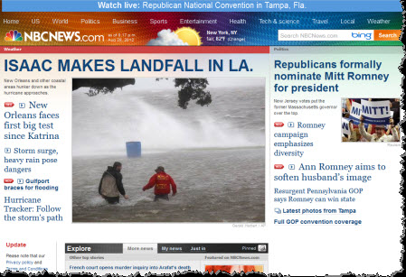
Aug 28 Isaac makes landfall in southeastern Louisiana
Aug 28 Isaac hits US Gulf Coast, heads for New Orleans
Aug 29 Hurricane Isaac makes 2nd landfall
Aug 29 Storm surge overtops levee, 12-foot flood...

Aug 30 Dam Failure Feared After Tropical Storm Isaac
Everyone could see that Isaac was a Katrina clone, ravaging the same region on the same date, exactly 7 years later. An echo anticipated in Aurora Code 2012 (7/21/2012):
August 29 - Babylon A.D. release date - adds to the pregnancy/birth theme as it is the birthday of the ancient Egyptian goddess Hathor, associated with the Milky Way/Nile and the flood ("water breaking") and considered a herald of imminent birth.
In 2005, August 29 was the exact date of New Orleans' "water breaking" impact moment when Hurricane Katrina made landfall there... right at the midpoint of a Galactic-Mayan timeline directly involving the year 2012.
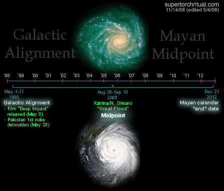
"Katrina" means "Catherine" as in Catherine"Kate" Middleton, i.e. the UK princess whose pregnancy/childbirth we've been long projecting for the Mayan window of 2012-2013 on our sites (Etemenanki/STRUG). [...]
"Maya" is today Mexico [as in "Gulf of Mexico"] and the name "Mexico" via Mextli refers to a "god of war" which in Roman mythology is Mars. "Mexico" via Mexihco means "Place at the Center of the Moon" implying "in the womb of Diana". [...]
...I'm going to go ahead and say that I see the latter part of August as a window for big things. Anchor dates ~August 24 and 29.
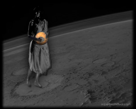
So we had the symbolism down beforehand and Isaac was a dramatic pattern fulfillment, the reality of which was confirmed and enhanced by additional eye-popping clues dropped on the other side of the Atlantic that same day...
It was the Paralympics opening ceremony in London on August 29 where Isaac Newton was being honored for his contribution to the expansion of human knowledge.

[Graphic from Paralympics opening ceremony]
Two Isaacs, same message. Isaac Newton is all about gravity and the (falling) apple, implying the following:
- "Gravity" is related to the Latin word gravidity (meaning "heavy") which is a scientific term for the state of pregnancy.
- "Apple" is the meaning of the term "Avalon" which is King Arthur's mythical "underworld" where he is said to be hibernating and would return from as the Once and Future King ("rebirth"), i.e. a drama unfolding at this time semi-literally through the rise of the Kate-William-baby trinity.

[Many apples during Paralympics opening ceremony]

A big exclamation mark came toward the end of the show in the form of a giant naked, pregnant woman based on an actual sculpture in London called "Alison Lapper Pregnant". I'm not kidding, see for yourself:
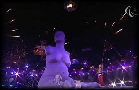
She was the centerpiece of the closing phase of the ceremony. For much of the duration of the show, however, the centerpiece was... the Moon.
The whole ceremony was lunar, and it was in London... together evoking Princess Diana. In this way, we were given another confirmation that the prevalent pregnancy/birth motif pertains mainly (but not exclusively) to the late princess's Arthurian descendants/family/bloodline. Kate Middleton while not related by blood is a worthy successor to Diana and is more than ready to bring a new life into this world with Prince William. My projection has always been that she would likely get pregnant in 2012 and give birth in the 2012-2013 time frame (naturally looking at 2013 now). We are talking " Grail bloodline" here and there was a blatant foreshadowing in the form of NASA's GRAIL twin probes entering orbit around the Moon right at the start of 2012 on New Year's Eve/Day. "GRAIL" here stands for " Gravity Recovery and Interior Laboratory".
As it happens August 29 is also New Year's Day ("1 Thoth") of the (Alexandrian) ancient Egyptian calendar. In ancient Egypt New Year's Day signified rebirth via the combination of the heliacal rising of Sirius and the annual inundation ("water breaking") of the Nile. Everything fits just beautifully. Pattern projected and fulfilled. At this stage there should be no denying that the pattern is real.
Golden Apple
We can start looking ahead using the same general pattern and specifically the golden apple which was conspicuously floating around at the opening ceremony on August 29. 
Thrown into a party, a golden apple becomes an unmistakable omen.... hinting at what amounts to a world war. Great chaos. That's the basic story of the Golden Apple of Discord in Greek mythology: goddess Discordia/Eris throws a golden apple with the inscription "for the fairest" into a wedding banquet, followed by a beauty contest, then the "abduction" of Helen as a direct consequence, sparking the Trojan War (ancient world war).
From my multicontextual point of view, it's no coincidence that the first impact event of 2012 was the Costa Concordia cruise ship disaster off Italy. "Concordia" is obviously the opposite (= upside down, like the wrecked ship) of "Discordia" (Eris) who threw the golden apple. Strong resonance there.
No coincidence especially if you take into account the fact that London was originally called "New Troy" according to legend...
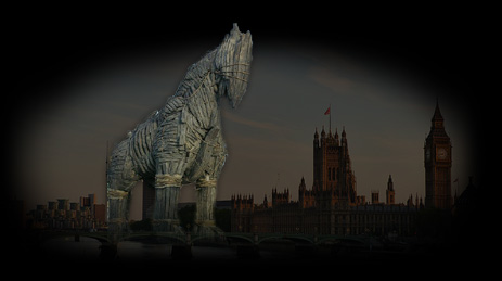
...and the fact that soon after the Paralympics great chaos was unleashed in the world starting around 9/11 (= big chaos/war date) coinciding with another big "Apple" event (iPhone 5):


Orange Alignment
Time: ~October 20, 2012
Themes: Golden apple/Orange, Chaos, Birthquake
For many years now we've been tracking what we call the "Orange Alignment" i.e. a heliocentric lining up of Venus, Sun and Mercury. I've shown many times before that when they come, we do feel their impact. It is my view that the next one coming up soon is a highly charged one... because, for one, in many languages the fruit orange is called... "golden apple".
 
The Orange Alignment will be formed in our solar system on ~October 20, 2012, like this:
Making it even more ominous, the alignment angle pinpoints the Earth's orbital position on January 12-13 (annual), which is the exact date of this year's Costa Concordia disaster (= Discordia => golden apple/orange) as well as the devastating Haiti earthquake (Birthquake) back in 2010. (Orange Alignments are often "earth changes" markers.)

That, to me, just does not look good. Some kind of big impact appears to be in the offing there (directly or indirectly) and I would expect it to continue to express the same underlying themes, but more intensely. Hopefully it's more about things like the Royal Pregnancy, Mars, etc. rather than severe earth changes, war, and such. There are obviously many possible scenarios and we may well be looking at multiple events (or just strong signals) unfolding simultaneously or in quick sequence.
I should also mention that there are other aspects of the whole golden apple business that points its temporal finger squarely at the year 2013. As well, before we even get there we'll have... certain things coming later this year which we'll need to talk about soon.
Enough for now. Thanks for reading!
https://www.goroadachi.com/etemenanki/golden_apple.html |
|
|
|
|
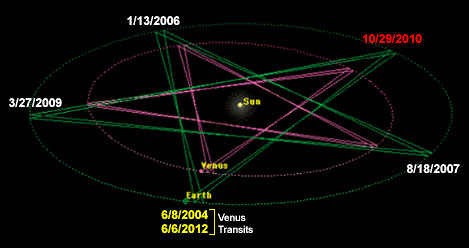
El pentagrama es una firma geométrica de Venus, lo que tiene mucho sentido en el contexto actual.
On June 5-6, 2012, a transit of Venus occurred, where Venus appeared as a small, dark spot passing across the face of the sun. This rare astronomical event happens in pairs, eight years apart, and is separated by 105 or 121 years. The transit began at 22:09 UTC on June 5, 2012, and ended at 04:49 UTC on June 6, 2012. The exact times varied by up to ±7 minutes depending on the observer's location.
|
|
|
|
|
Thanks for the post and great tips: even I also think that hard work is the most important aspect of getting success www.versatilelanguages.com |
|
|
|
|
hace 8 horas — Más que un ornamento, el escudo de León XIV es una declaración de principios: unidad, espiritualidad encarnada y una vocación marcada por el ...
hace 11 horas — Como miembro de la Orden de San Agustín desde 1977 y habiendo sido prior general de la misma, León XIV es el primer pontífice agustino en la ...
hace 5 días — Representa al pastor curial, es el único obispo que no quiso jurar fidelidad a Napoleón y que se gastó totalmente por el pueblo romano.
hace 3 días — La imagen fue tomada el 28 de agosto de 2004 en la parroquia San Agustín, ubicada en el barrio porteño de Recoleta, durante una celebración ...
YouTube · TVPerú Noticias
YouTube · Univision Noticias
hace 2 horas — Es el segundo papa de procedencia americana así como también es el primer papa perteneciente a la Orden de San Agustín. Pese a que Eugenio IV y otros ...
hace 12 horas — En 2004, Roberto Prevost vistió Argentina y bendijo este espacio de la Orden de San Agustín ubicado en avenida Nazca al 3900.
hace 3 días — El nuevo Papa elegido este jueves, León XIV, es el primer agustino en dirigir la Iglesia católica. Como indica su nombre, la orden sigue la ...
hace 2 días — El Vaticano publica el escudo oficial del Papa León XIV, vinculado a San Agustín. El escudo pontificio conserva la forma y los elementos ...
|
|
|
 Primer Primer
 Anterior
1307 a 1321 de 1321
Siguiente Anterior
1307 a 1321 de 1321
Siguiente
 Último

|









 Aug 26


