|
|
  

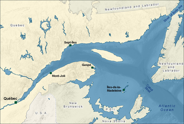
Between mid-June and mid-September each year, CTMA offers weekly cruises between Montréal, Québec City, the Gaspé Peninsula and Les Îles de la Madeleine. The archipelago of Îles de la Madeleine is far out into the Gulf of St Lawrence: 215 km from Québec’s Gaspé, 105 km from Prince Edward Island and 95 km from northern Nova Scotia’s Cape Breton Island. Now you know! Map Courtesy of Express Design

Some 320 million years ago, before continental drift began to separate the land masses, Les Îles de la Madeleine were located close to the earth’s equator in a basin which was actually below sea level and where the average ambient temperature was 38°C (100°F). Seawater flowed often into this basin and its evaporation caused layers of salt to accumulate on its floor. Over time, this layer of accumulated salt grew to a depth of 5 kilometers. Meanwhile, the Îles de la Madeleine started their very long migration towards the north, eventually ending up in the Gulf of Saint Lawrence. Geological activity subsequently covered the salt with another 4 kilometers of rock and lava.
Between 2 and 5 million years ago, the pressure of the rocky layer overlaying the salt raised its temperature to nearly 300°C (572°F). The salt, now more fluid and malleable than the rocky layer directly above, rises towards the surface. Pressure from rising salt lifts the overlaying rock, creating the famous salt domes supporting Îles de la Madeleine. Visible evidence of this upshift is the large active salt mine on one of the north islands.
The rocks of the main islands are composed primarily of volcanic rock, sedimentary rock and sandstone. The rocky cores are linked by sandy spits whose surface is always affected by the winds which created the dunes, some of which, called “buttereaux” reach up to 15 meters in height.

Lying in a south-west/north-easterly direction, Îles de la Madeleine consists of a dozen islands that form a 65-kilometer-long fishhook-shaped archipelago of 202 square kilometers. The six main inhabited islands are interconnected by long, thin sand dunes joined by paved roads and bridges. Islanders live in the Atlantic Time Zone, one hour ahead of mainland Québec. Courtesy of Tourisme Iles de la Madeleine
Return to our richly-illustrated feature article about cruising from Montréal to Les Îles de la Madeleine.
https://www.travelwithachallenge.com/?page_id=3840 |
|
|
 Primer
Anterior
2 a 5 de 5
Siguiente
Primer
Anterior
2 a 5 de 5
Siguiente
 Último
|
|
|
The Estuary and the Gulf of St. Lawrence
The St. Lawrence River begins as the outflow of the Great Lakes and widens into a large estuary near Ile d’Orléans, where the river’s fresh water first encounters oceanic salt water and where the typical two-layer estuarine circulation begins. Continuing downstream, the surface water of the St. Lawrence becomes more and more salty, finally having a true oceanic character at the head of the Laurentian Channel (off-shore of Tadoussac), where strong upwellings bring deep waters to the surface.
Among the deepest and largest estuaries in the world, the St. Lawrence maritime estuary extends nearly 250 km before it widens at Point-des-Monts into the Gulf of St. Lawrence. This enclosed sea is connected to the Atlantic Ocean by Cabot Strait and the Strait of Belle-Isle.
https://www.qc.dfo-mpo.gc.ca/en/estuary-and-gulf-st-lawrence |
|
|
|
|
The St. Lawrence River
November 1, 2014 Jennifer Hayes
David Doubilet and I live in the Thousand Islands region of the St. Lawrence River — not by accident or because I grew up near here but rather by design and desire. The St. Lawrence Seaway, a boulevard for international shipping, is literally our backyard. The low rumble of ships and soul-soothing songs of loons waft through our house and office.
We recently had an incredible opportunity to explore the length of the St. Lawrence, from our dock near Lake Ontario to the distant shores of Newfoundland and Labrador, for a National Geographic magazine article published in May 2014. The proposed development of a significant petroleum discovery known as “Old Harry” in the Gulf of St. Lawrence provided the incentive to explore and share what is at risk in the surrounding waters. With the help of our colleagues Michel Gilbert and Danielle Alary, we began planning our expedition.
Our dock is only minutes away from shipwrecks, storybook castles and sturgeon. In late May, when the river temperature touches 50°F, lake sturgeon gather to spawn on nearby gravel beds. A 3- to 5-knot current roars across their spawning areas, aerating their precious carpet of eggs. Diving here with this ancient, threatened species is like swimming against a fire hose. These magnificent fish can live 100 years and are programmed for slow reproduction: Females first spawn at 25 years and males at 14-16 years. Against a backdrop of diminishing habitat and unsustainable harvest for caviar, this is leading to crises in sturgeon populations worldwide.
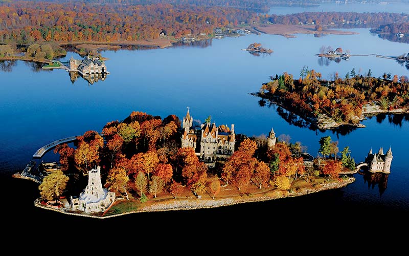 Boldt Castle, shown here in the fall, sits in the heart of the Thousands Islands, St. Lawrence River.
The river widens into one of the world’s deepest, richest estuaries as it approaches the Laurentian Trench at Tadoussac, Quebec. The upwelling of 38°F, nutrient-filled water supports the 13 species of whale that inhabit the St. Lawrence system, many of them found within the Saguenay–St. Lawrence Marine Park boundaries. We worked with Groupe de recherche et d’éducation sur les mammifères marins [Group for Research and Education on Marine Mammals] (GREMM) scientists to make images of beluga whales. The St. Lawrence belugas are a beloved and well-studied population in the midst of a desperate downturn due to an inexplicable increase in infant mortality. One spunky beluga approached us out of the green gloom. He puckered his blubbery lips and blew a bubble, cautiously advanced and ever so slowly opened his pink mouth wide and then wider, trying to taste test the Seacam housing.
Famed Quebec divers Paul Boissinot and Georges Mamelonet met us in Percé, Quebec, to guide us to Bonaventure Island in the gulf near Percé. Bonaventure supports one of the largest northern gannet colonies in the world, and great herds of gray seals rest here during their migrations. We were photographing 12-pound lobster brutes patrolling the bottom when I was surprised by a squeeze on my behind. I thought the pinch was David’s signal to surface, but I turned around to find a gray seal that then playfully pulled at my fins and tried to swallow my dome. These beautiful seals have senses of humor and behave like puppies. Sadly they are the subjects of a controversial cull that’s been proposed to remove 70 percent of their number from the gulf in an attempt to resuscitate cod stocks.
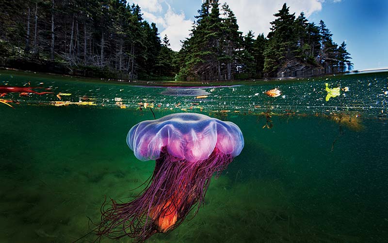 A lion’s mane jellyfish moves gently through the rich shallows of Bonne Bay Fjord in Newfoundland.
We crossed the gulf to the west coast of Newfoundland to meet up with Rick Stanley and Robert Hooper, Ph.D., to explore the deep, cold and clear fjords of Bonne Bay. The plummeting rock walls of the fjord are covered in startlingly dense carpets of stalked anemones. The gentler slopes are home to Atlantic wolffish, which peered out at us from their dens. Their grumpy, gray and somewhat comical expressions reminded David of some of his relatives from Montreal. We surfaced from every dive into a living painting of sunlit coves filled with golden algae and flounders that wafted like leaves. Lion’s mane jellyfish of every shape, size and color pulsed past a striking Canadian canvas of evergreens and ancient rock, a perfect stage for David’s signature half-and-half imagery.
Winter transforms the gulf into a surreal world of relentless wind and shifting sea ice. It is the kingdom of the harp seal. For us this is the heart of the St. Lawrence, and we have become hypnotized by its raw beauty. Harp seals are born on the ice in late February, nursed for 12-15 days and then abandoned by their mothers to learn how to be harp seals. We met diver Mario Cyr in Îles-de-la-Madeleine and took a fishing boat and pushed into the thinning sea ice, which supported 10,000 harp seals. We descended into the seals’ icy world, where frantic, paranoid mothers come and go from the ice shelf, and the wary pups learn to swim.
Testosterone-fueled males swirl beneath the ice pack eagerly awaiting an opportunity to mate. There is a tense pulse of life in this cold and challenging world. We spent days in the ice, the pups’ cries echoing through the steel hull, sounding like those of human babies. The diving was exhilarating and exhausting. We experienced life-changing encounters that will stay with us.
As we left the seals we were met with a storm that pummeled the weak sea ice, turning it into a blender and killing most of the pups in the gulf for the second year in a row. Warming in the gulf has led to poor and unstable ice that disintegrates beneath the pups.
This dynamic and evolving winter world of the Gulf of St. Lawrence is a current that runs through our lives. We migrate back each year when the frozen sea silence is broken only by the wind and the cries of the harp seal.
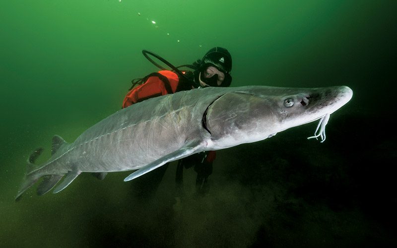 Jennifer Hayes swims with a decades-old female lake sturgeon on her way to the spawning grounds.
https://dan.org/alert-diver/article/the-st-lawrence-river/ |
|
|
|
|
Solstice Hellgate Activation
By Goro
January 3, 2014 (orig. Dec 25, 2013)
The original version of the following article was posted on my Super Torch Ritual Underground (STRUG) blog site back on December 25, 2013. I just decided to post the piece as-is without making any adjustments (with few exceptions) and as such some links going to posts inside STRUG will not work for non-members and there are also some references that will not be familiar to those outside of STRUG. Nevertheless overall it shouldn't be much of a problem for readers here.
Contact... with the Devil?
In the buildup to the highly-charged temporal window, all indications were that Winter Solstice 2013 would produce major events... something "deep impact" and/or something deeply meaningful in the multicontextual reality matrix that would go perfectly with the various interconnected patterns we've been following. Already, a cluster of heavily intertwined world events with significant multicontextual implications have caught our attention...
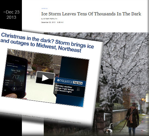
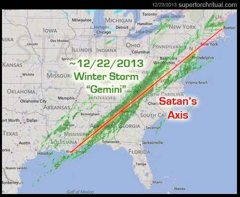
But the "big one", which I was saving for this post, was Winter Storm "Gemini". Making big headlines right around December 21-22...

I had specifically stated that Orange/Golden Apple Alignments (pinpointing ~Dec 21) tend to coincide with "earth changes" type events...
...and that's what we got here as well, except this wasn't a super major, deadly quake or a hurricane/typhoon as you might have expected but a little more understated variety in the form of a powerful winter storm. What it lacked in physical impact, however, it made up for in scale and precision.Shown on a map (see below), Winter Storm Gemini was a visually striking straight line, moving up diagonally from the Gulf of Mexico to the US Northeast...
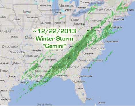 It was observant reader Mithras who first brought it to my attention, that this storm line was perfectly tracing a certain esoteric "ley line" connecting many major cities along the US East Coast known in the past, apparently at least according to one source, as "Satan's Axis". (I have talked about it many years ago.) Thus, a clear and unsettling continuation/escalation of our "devil" motif/communication [that had been discussed on STRUG].
From The Labyrinth of the Grail by William F. Mann (pp.74-75):
If the inner secrets of Masonry do not lie in Hell where do they lie? Of course, they lie in Heaven. But Heaven needs Hell. Thus, through Craft Masonry the initiate learns that the original columns of the temple were hollow and each supported a globe, one representing a map of the world and the other a map of the heavens. In many ways the "mappamundi" produced in the fourteenth to sixteenth centuries reflects this notion where one ring or circle illustrates what was known of the eastern world at that time and the western circle represents the New World - L'Arcadia. Could mappamundi refer to a world created by the Cathar god of evil - Rex Mundi, "King of the World?"
If true, then it goes a long way to explain why the lands of the New World purportedly fell along what was considered in the sixteenth century to be SATAN'S AXIS, that line beyond what was known of the world at the time. Satan's Axis not only runs lengthwise through Nova Scotia but also extends through Boston, New York, Philadelphia, and along the Allegheny Mountains - all renowned areas of early occult and witchcraft practice.
Beyond coincidence is the fact that the largest manganese and coal deposits within Nova Scotia lie along this so-called Satan's Axis. And there is the evidence presented by Barry Fell in America B.C. that the majority of pre-Columbian relics and remnants found in North America also relate to this axis.
It's also been my observation that if Satan's Axis is extended beyond the New World towards Europe, it pinpoints... Paris. Making the great-circle axis not only "Trojan" but also Sirian. (Remember, Paris is semi-officially an Isis-Sirius city.) Symbolically perfect in this way, as the ISS (Isis) was making big headlines simultaneously on the solstice/Dec 21...
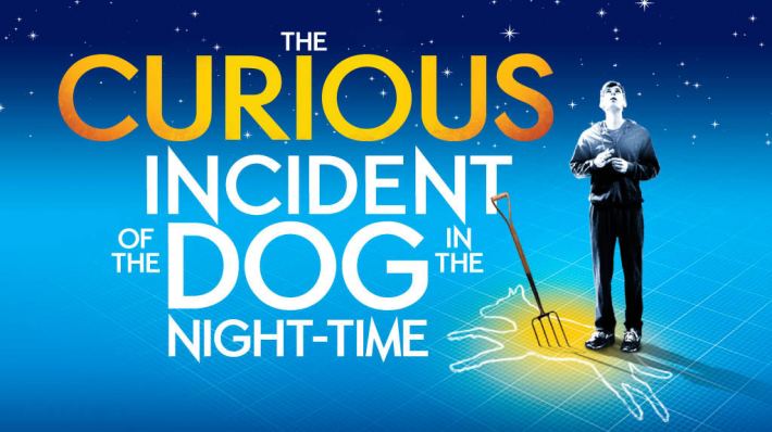
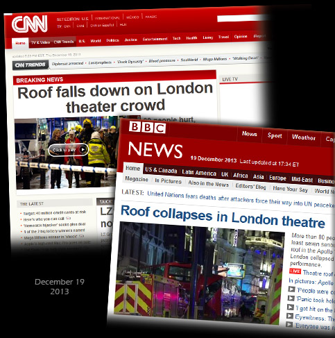
And this was just a couple of days after another very Sirian signal event, the Apollo Theatre ceiling collapse, where the play "The Curious Incident of the Dog in the Night-Time" was being performed.
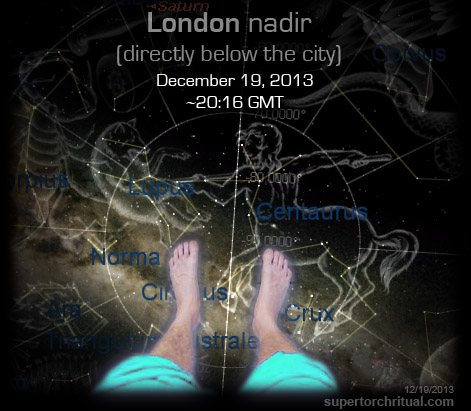
 Dec 19, 2013 The Apollo Theater Code Dec 19, 2013 The Apollo Theater Code
At the time of the roof collapse at ~20:15 GMT in London, Sirius - aka the "Dog Star" - was rising right at the horizon!

Not only that, to reflect the play which revolves around a dog pierced by a garden fork, directly below London (nadir) at the time of the roof collapse was Centaurus piercing Lupus...

Now this nadir-based configuration is something that reminds us of this year's Super Bowl Galactic Center/Dark Rift alignment that was being formed at the time of the blackout incident following the Beyonce/Destiny's Child halftime show...
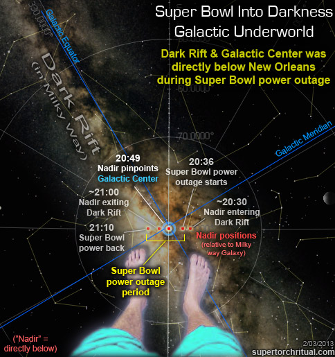 
It is certainly very fitting that the city New Orleans has its "voodoo" tradition, resonating with our "devil" motif. The Super Bowl certainly had a devil theme going as well, if you recall...
 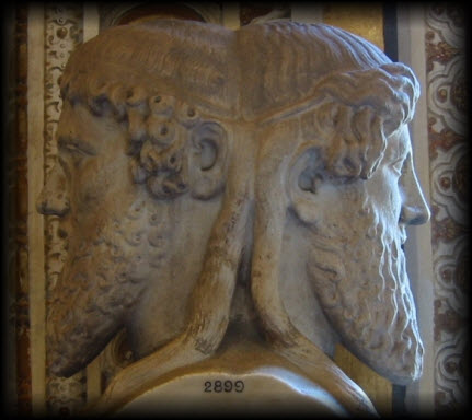
Two faces => god Janus => "Janus" = name of
main antagonist in Angels & Demons (book version)
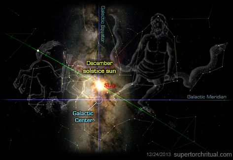
All these remarkable coincidences find another strong pattern confirmation in the fact that the Super Bowl halftime entertainer Beyonce just released her new album, digitally (iTunes) on December 13 and physically on... December 20 the day before solstice. It created a big buzz because her self-titled "visual" album Beyonce came out of nowhere and took people by surprise as it had been kept very secret, going by the code name "Lily" as in fleur-de-lis, a popular symbol of New Orleans.At this point we can start putting the two and two together... The Galactic Center/Dark Rift and the devil/Satan... evoking the Mayan Underworld. Because the Milky Way's "Dark Rift" - a long black streak running through a segment of the celestial river overlapping the Galactic Center - was considered by the Mayans to be a road to Xibalba, their (heavenly) Underworld or Hell. ("Xibalba" means "Place of fear".) That's the domain of the devil/Satan of course.
Interestingly in Mayan tradition their Underworld had 9 levels. This is particularly meaningful in the context of Thor: The Dark World released just last month (Nov 2013) right at the time of the "Phoenix Storm" Hiayan/Yolanda. That was another big storm (if not the biggest ever). In addition to "The Dark World" evoking the Dark Rift Underworld, the movie's plot is centered around the idea of an alignment of the "Nine Realms" formerly connected by the "Rainbow Bridge".
In present-day Asgard, Loki stands imprisoned for his war crimes on Earth. Meanwhile, Thor, alongside warriors Fandral, Volstagg and Sif, repels marauders on Vanaheim, home of their comrade Hogun; it is the final battle in a war to pacify the Nine Realms following the reconstruction of Bifröst, the "Rainbow Bridge" between realms, which had been destroyed two years earlier. The Asgardians soon learn that the Convergence, a rare alignment of the Nine Realms, is imminent; as the event approaches, portals linking the worlds appear at random.
And Thor is not only the god of storms, but also the Norse version of Jupiter/Zeus. Where was the planet Jupiter during all this? In the constellation Gemini... the namesake of Winter Storm Gemini.
https://www.goroadachi.com/etemenanki/solstice_hellgate.html
|
|
|
Primer
Anterior
2 a 5 de 5
Siguiente
Último
|


 Dec 19