


The Liberty Bell and America's Independence from God - plus - Bells Across America - DO NOT PARTICIPATE! Yom Kippur - DO PARTICIPATE!
[Updated 9/27/2010]
I've personally received a number of very obvious signs lately, and these are related to this specific season and the arrival of judgment for the Lord's people, and also the bell. Yes, bells that ring. I'm interrupting the work of preparing two other urgent and important related writings because of what just came to my attention.
Today, Friday September 17, 2010, is the 223nd anniversary of the signing of the US Constitution. It's final form was adopted by the Constitutional Convention in Philadelphia on Sept. 17, 1787, at Independence Hall. This will be celebrated across America with the ringing of bells. Web search "bells across america" The long version of what I've been working on is not ready for posting yet, but let me tell you - this is not a good thing! Don't participate. Ring no bell at this time! Some have scheduled the ringing for 4pm. I personally expect to be making intercessory prayer at that time.
One of the signs came on Yom Teruah, this past Saturday morning. This was unplanned and unexpected, but I was led to go through my nearly full pocket change jar and roll the pennies. When I was done, I arranged them in pairs for easy counting at 2 rolls per dollar. I counted $11. That's 22 rolls! 22=11*2. I know what that signals. I've encountered it enough times to recognize it immediately. I had just been counting all the pennies and wrapping 50 per roll. When I was done wrapping, I knew I was done, with not one roll too many or too few, even though there were at least a few hundred more pennies left in the jar. When I counted $11 dollars in rolled pennies and saw the arrangement I had made with the 22 rolls it was obviously a sign. I didn't know the context of its interpretation until returning to blogging the next day. The post I had tried to write a few days earlier had to be rewritten. The Lord had something better in mind. The theme is going to match the post's number, number 22 in the Rochester, NY series. I had already noticed how the 21st post featured time-keeping. I had not planned it to correspond like this, but one of the meanings of 21 is "time." The theme matched the post's number! He has established a trend.
As I reviewed what I'd written already, I reflected back on post 21 and what really needed to be the focus of the next one. It was the bells, by revelation insight. I'm going to include something later in this post of what I had written that could not yet be posted in that context. It's for this post! As I studied to learn more about bells, bell ringing and bell towers I began to understand about the sign of the 22 rolls of pennies and how the post #22 was to be a bell and bell tower post. Bells and pennies have a very similar brass composition. Bells for ringing are generally 80% copper and 20% tin. Pennies (USA), although changing through the years, were composed of 95% copper and 5% tin and zinc, from 1864 until 1943.
Yesterday, Thursday, came another sign. I went to the barbershop for a haircut. I was going to go earlier than I did, but decided to wait so that lunch-time haircut folks wouldn't be inconvenienced. My schedule is flexible. When I did go, I usually walk the ten minutes it takes but decided instead to drive. Within a minute of my being there, the fellow in the barber's chair began to tell the barber he owned a foundry that made bells, and that he was a bell designer. Right. I've been intensely focused on bells for days and I walk in on that conversation. The odds? Absurd. It's another sign! He talked for a good half hour about the bells and his being on TV shows and interviewed for magazines and papers. I considered joining the conversation a few times but decided to keep quiet and just listen. A half-hour haircut? At least! When I got home I did some research to check up on the guy's story, his foundry, etc. He's legit.
The number 22 (from the coin sign and the numbered post in the Rochester series) can be understood by expressing it as 11*2. "Eleven" signifies the flesh of man as grass and the flower of grass, frail and ephemeral - here today and gone tomorrow. "Two" signifies division. "Twenty-two" signifies the division, cutting or cutting off the flesh, as in the work of the cross in the life of the saint, resulting ultimately in the death of the flesh. As my dear brother Joseph Herrin observed, there's a reason why the 22" size is the most popular for grass-cutting machines. The sovereign Creator numbers His creation perfectly. This theme of 22 is a primary signification of the bell and bell tower, a symbolic and magickal element of Rochester, NY's Clock of Nations. It's also the theme of this season's judgment and the national bell ringing.
Following New Zealand's Christchurch quake sign and, being in the midst of the celestial sign of Neptune, plus the penny rolls on Yom Teruah (Day of shouting and day of trumpets - trumpets are also typically made of brass, and have "bells" to project the sound), plus the encounter with the Bell man, (whose real claim to fame is the California Mission Bell project along El Camino Real) - on top of several other things, I have to tell you, I'm convinced we are in a critical season - right now. What I believe all this means is that, even beyond today's national bell ringing, the day of most critical importance is coming up in a couple days.
The biblical account of bells focuses attention upon their use on Yom Kippur. On that day, the High Priest would go into the Most Holy Place and make atonement for Israel.
33) You shall make on its hem pomegranates of blue and purple and scarlet material, all around on its hem, and bells of gold between them all around:
34) a golden bell and a pomegranate, a golden bell and a pomegranate, all around on the hem of the robe.
35) It shall be on Aaron when he ministers; and its tinkling shall be heard when he enters and leaves the holy place before the LORD, so that he will not die.
36) You shall also make a plate of pure gold and shall engrave on it, like the engravings of a seal, 'Holy to the LORD.'
37) You shall fasten it on a blue cord, and it shall be on the turban; it shall be at the front of the turban.
38) It shall be on Aaron's forehead, and Aaron shall take away the iniquity of the holy things which the sons of Israel consecrate, with regard to all their holy gifts; and it shall always be on his forehead, that they may be accepted before the LORD.
Exodus 28:33-38
As the Lord may lead, fasting and prayer, very serious personal repentence and intercession may be called for in these days of awe. Yom Kippur is, by Karaite reckoning, September 19-20, sundown to sundown, Jerusalem time. Seek the Lord personally about specifics as to timing for you, of course. For those of you who work or have other obligations, some advance planning may be called for to free up your time and your families time from distractions. I'm convinced this is that urgent and that important.
What I had written for the intended post 22 follows. It's about what today's "Bells Acroll America" celebrates, about Independence Hall, where the event took place. This is what the Liberty Bell in Independence Hall was about! Observe how the Liberty Bell points us towards Yom Kippur, the holy day on which the Yobel or Jubilee is proclaimed! Note the sign of it's cracking, and that it exists today in such a state.
The Liberty Bell and America's Independence from God
What we call the Liberty Bell was commissioned from the London firm of Lester and Pack in 1752. It was brought to Philadelphia and hung in the steeple of the Pennsylvania State House, aka Independence Hall. It first cracked when first rung in Philadelphia. An inscription on the bell excerpts Leviticus 25:10: "Proclaim LIBERTY throughout all the land unto all the inhabitants thereof." When the bell cracked, that was a sign!
Here's more of the context of the bell's inscription.
8) And thou shalt number seven sabbaths of years unto thee, seven times seven years; and the space of the seven sabbaths of years shall be unto thee forty and nine years.
9) Then shalt thou cause the trumpet of the jubile to sound on the tenth day of the seventh month, in the day of atonement shall ye make the trumpet sound throughout all your land.
10) And ye shall hallow the fiftieth year, and proclaim liberty throughout all the land unto all the inhabitants thereof: it shall be a jubile unto you; and ye shall return every man unto his possession, and ye shall return every man unto his family.
The passage of scripture declares the institution of the Yobel, the Jubilee, and the accounting of the appointed times. The Yobel was to be observed faithfully until such time as when it would find its ultimate fulfillment. Was honoring the Creator's times and purposes in the minds and hearts of those who commissioned the inscription on the bell? It must be seen that they rather mocked Him and His ordinances. God is not mocked, for long. When first rung in Philadelphia, the city of brotherly love, the bell cracked. It was a sign. Hijacking His appointed times and purposes will not stand, for long. The "liberty" sought is independence from the Creator, his authority and all institutions of purpose and time.
Independence Hall with its clock and associated Liberty Bell are icons of proud Philadelphia and America itself. The well hidden secret testimony is about America's independence from the Creator. This is exactly counter to what you will hear in nearly every bell tower institution where the presumed god of our proud country's founders is named.
The Liberty Bell is an Isis bell, the fertile womb of Mystery Babylon. It's a symbol of the "liberty" that is independence from God. The Liberty Bell and the clock on the bell tower of Independence Hall signal America's fertile founding as a rebel's paradise.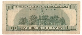
Featured on the back of the Federal Reserve's one hundred dollar note is the clock tower of Independence Hall in Philadelphia, PA.
The Federal Reserve imprints their notes and coins with occult symbolism. The great seal on the back of the one dollar note is famously adorned with occult symbolism. I've recently blogged about how coins have numeric features that make them particularly special when tossed into fountains. That Freemasonry and Luciferian illuminism is behind the imagery is well documented. The Independence Hall clock tower on the one hundred dollar note must be important. It was featured in the movie franchise "National Treasure" as a major plot device. The time displayed on the clock was a clue that had to be deciphered, concealed and revealed through the symbols of America and Freemasonry. When I consider the Independence Hall clock I perceive a clue that leads me to another kind of treasure!
The clock on Independence Hall is a parable. Clocks serve to disassociate people from the natural ways that honor the Creator. Individuals and communities governed by clocks are disassociated, disconnected in their relationship with the Creator, thus operating independent of Him. The clock ... on Independence Hall - get it? The treasure here is insight into the truth behind what is meant by independence!
When most people see the word in that context, what comes to mind is obviously, "independence from Britain." Independence Hall in Philadelphia is the very place where the Declaration of Independence was signed in 1776. That document begins, "When in the Course of human events, it becomes necessary for one people to dissolve the political bands which have connected them with another..." There can be no doubt that independence meant the establishment of a nation independent of the British Empire. Beyond that lies a greater truth, one to which the clock bears witness; one that is difficult for some to accept. The clock testifies of a community of men who have rebelled against the rule of the Creator by replacing His provision for the governance of their activity with another. This, my friend, is precisely what Independence Hall stands for.
1) Let every soul be subject unto the higher powers. For there is no power but of God: the powers that be are ordained of God.
2) Whosoever therefore resisteth the power, resisteth the ordinance of God: and they that resist shall receive to themselves damnation.
3) For rulers are not a terror to good works, but to the evil. Wilt thou then not be afraid of the power? do that which is good, and thou shalt have praise of the same:
4) For he is the minister of God to thee for good. But if thou do that which is evil, be afraid; for he beareth not the sword in vain: for he is the minister of God, a revenger to execute wrath upon him that doeth evil.
5) Wherefore ye must needs be subject, not only for wrath, but also for conscience sake.
6) For for this cause pay ye tribute also: for they are God's ministers, attending continually upon this very thing.
7) Render therefore to all their dues: tribute to whom tribute is due; custom to whom custom; fear to whom fear; honour to whom honour.
Romans 13:1-7
There is no provision in Romans 13 for saints to declare independence from the British Empire. King George III was the higher power, ordained of God. If you read the Declaration of Independence with humility, the inescapable conclusion is that rebellion against the rule of King George III was rebellion against the sovereign God's appointed regent, and therefore against God's authority and God Himself!
The Declaration of Independence presumes through proud and lofty language to have a mandate for such action as was subsequently taken to secure such independence. "... it is their right, it is their duty, to throw off such Government, and to provide new Guards for their future security." There was no such mandate, biblically, but only in the minds of lawless and rebellious men, most of them Freemasons, deceived and deceivers.
According to Albert G. Mackey, on page 374 of the "Encyclopedia of Freemasonry, Part 1," you may read about the cornerstone for the State House (Later known as Independence Hall) being laid by Benjamin Franklin during his administration as Grand Master, with the Brethren of Philadelphia's St. John's Lodge, Libre B.
I must emphasize the need to honestly read the witness of the clock on Independence Hall so we're not deceived. America runs on Babylon time, which is GMT. How is that independent from the British Empire? Understand about the Liberty Bell. These icons of America declare its independence from our Creator while declaring its idolatrous dependence upon the gods of Babylon.
Consider this statement from usgovinfo.about.com.
"No matter how much we argue about the details of its meaning today, in the opinion of many, the Constitution signed in Philadelphia on September 17, 1787 represents the greatest expression of statesmanship and compromise ever written. In just four hand-written pages, the Constitution gives us no less than the owners' manual to the greatest form of government the world has ever known." Constitution Day To that I say shame on us if we buy into that bold and wickedly foolish rejection of the Creator's authority and governance.
Have you read Is Your God American? and been convicted by it? Those whose god is American are idolators. The time has come to repent of this and all idolatry. The time has come. This is my firm conviction.
See also The Judgment Has Begun by Joseph Herrin (09-17-2010)
I've personally received a number of very obvious signs lately, and these are related to this specific season and the arrival of judgment for the Lord's people, and also the bell. Yes, bells that ring. I'm interrupting the work of preparing two other urgent and important related writings because of what just came to my attention.
Today, Friday September 17, 2010, is the 223nd anniversary of the signing of the US Constitution. It's final form was adopted by the Constitutional Convention in Philadelphia on Sept. 17, 1787, at Independence Hall. This will be celebrated across America with the ringing of bells. Web search "bells across america" The long version of what I've been working on is not ready for posting yet, but let me tell you - this is not a good thing! Don't participate. Ring no bell at this time! Some have scheduled the ringing for 4pm. I personally expect to be making intercessory prayer at that time.
One of the signs came on Yom Teruah, this past Saturday morning. This was unplanned and unexpected, but I was led to go through my nearly full pocket change jar and roll the pennies. When I was done, I arranged them in pairs for easy counting at 2 rolls per dollar. I counted $11. That's 22 rolls! 22=11*2. I know what that signals. I've encountered it enough times to recognize it immediately. I had just been counting all the pennies and wrapping 50 per roll. When I was done wrapping, I knew I was done, with not one roll too many or too few, even though there were at least a few hundred more pennies left in the jar. When I counted $11 dollars in rolled pennies and saw the arrangement I had made with the 22 rolls it was obviously a sign. I didn't know the context of its interpretation until returning to blogging the next day. The post I had tried to write a few days earlier had to be rewritten. The Lord had something better in mind. The theme is going to match the post's number, number 22 in the Rochester, NY series. I had already noticed how the 21st post featured time-keeping. I had not planned it to correspond like this, but one of the meanings of 21 is "time." The theme matched the post's number! He has established a trend.
As I reviewed what I'd written already, I reflected back on post 21 and what really needed to be the focus of the next one. It was the bells, by revelation insight. I'm going to include something later in this post of what I had written that could not yet be posted in that context. It's for this post! As I studied to learn more about bells, bell ringing and bell towers I began to understand about the sign of the 22 rolls of pennies and how the post #22 was to be a bell and bell tower post. Bells and pennies have a very similar brass composition. Bells for ringing are generally 80% copper and 20% tin. Pennies (USA), although changing through the years, were composed of 95% copper and 5% tin and zinc, from 1864 until 1943.
Yesterday, Thursday, came another sign. I went to the barbershop for a haircut. I was going to go earlier than I did, but decided to wait so that lunch-time haircut folks wouldn't be inconvenienced. My schedule is flexible. When I did go, I usually walk the ten minutes it takes but decided instead to drive. Within a minute of my being there, the fellow in the barber's chair began to tell the barber he owned a foundry that made bells, and that he was a bell designer. Right. I've been intensely focused on bells for days and I walk in on that conversation. The odds? Absurd. It's another sign! He talked for a good half hour about the bells and his being on TV shows and interviewed for magazines and papers. I considered joining the conversation a few times but decided to keep quiet and just listen. A half-hour haircut? At least! When I got home I did some research to check up on the guy's story, his foundry, etc. He's legit.
The number 22 (from the coin sign and the numbered post in the Rochester series) can be understood by expressing it as 11*2. "Eleven" signifies the flesh of man as grass and the flower of grass, frail and ephemeral - here today and gone tomorrow. "Two" signifies division. "Twenty-two" signifies the division, cutting or cutting off the flesh, as in the work of the cross in the life of the saint, resulting ultimately in the death of the flesh. As my dear brother Joseph Herrin observed, there's a reason why the 22" size is the most popular for grass-cutting machines. The sovereign Creator numbers His creation perfectly. This theme of 22 is a primary signification of the bell and bell tower, a symbolic and magickal element of Rochester, NY's Clock of Nations. It's also the theme of this season's judgment and the national bell ringing.
Following New Zealand's Christchurch quake sign and, being in the midst of the celestial sign of Neptune, plus the penny rolls on Yom Teruah (Day of shouting and day of trumpets - trumpets are also typically made of brass, and have "bells" to project the sound), plus the encounter with the Bell man, (whose real claim to fame is the California Mission Bell project along El Camino Real) - on top of several other things, I have to tell you, I'm convinced we are in a critical season - right now. What I believe all this means is that, even beyond today's national bell ringing, the day of most critical importance is coming up in a couple days.
The biblical account of bells focuses attention upon their use on Yom Kippur. On that day, the High Priest would go into the Most Holy Place and make atonement for Israel.
33) You shall make on its hem pomegranates of blue and purple and scarlet material, all around on its hem, and bells of gold between them all around:
34) a golden bell and a pomegranate, a golden bell and a pomegranate, all around on the hem of the robe.
35) It shall be on Aaron when he ministers; and its tinkling shall be heard when he enters and leaves the holy place before the LORD, so that he will not die.
36) You shall also make a plate of pure gold and shall engrave on it, like the engravings of a seal, 'Holy to the LORD.'
37) You shall fasten it on a blue cord, and it shall be on the turban; it shall be at the front of the turban.
38) It shall be on Aaron's forehead, and Aaron shall take away the iniquity of the holy things which the sons of Israel consecrate, with regard to all their holy gifts; and it shall always be on his forehead, that they may be accepted before the LORD.
Exodus 28:33-38
As the Lord may lead, fasting and prayer, very serious personal repentence and intercession may be called for in these days of awe. Yom Kippur is, by Karaite reckoning, September 19-20, sundown to sundown, Jerusalem time. Seek the Lord personally about specifics as to timing for you, of course. For those of you who work or have other obligations, some advance planning may be called for to free up your time and your families time from distractions. I'm convinced this is that urgent and that important.
What I had written for the intended post 22 follows. It's about what today's "Bells Acroll America" celebrates, about Independence Hall, where the event took place. This is what the Liberty Bell in Independence Hall was about! Observe how the Liberty Bell points us towards Yom Kippur, the holy day on which the Yobel or Jubilee is proclaimed! Note the sign of it's cracking, and that it exists today in such a state.
The Liberty Bell and America's Independence from God
What we call the Liberty Bell was commissioned from the London firm of Lester and Pack in 1752. It was brought to Philadelphia and hung in the steeple of the Pennsylvania State House, aka Independence Hall. It first cracked when first rung in Philadelphia. An inscription on the bell excerpts Leviticus 25:10: "Proclaim LIBERTY throughout all the land unto all the inhabitants thereof." When the bell cracked, that was a sign!
Here's more of the context of the bell's inscription.
8) And thou shalt number seven sabbaths of years unto thee, seven times seven years; and the space of the seven sabbaths of years shall be unto thee forty and nine years.
9) Then shalt thou cause the trumpet of the jubile to sound on the tenth day of the seventh month, in the day of atonement shall ye make the trumpet sound throughout all your land.
10) And ye shall hallow the fiftieth year, and proclaim liberty throughout all the land unto all the inhabitants thereof: it shall be a jubile unto you; and ye shall return every man unto his possession, and ye shall return every man unto his family.
The passage of scripture declares the institution of the Yobel, the Jubilee, and the accounting of the appointed times. The Yobel was to be observed faithfully until such time as when it would find its ultimate fulfillment. Was honoring the Creator's times and purposes in the minds and hearts of those who commissioned the inscription on the bell? It must be seen that they rather mocked Him and His ordinances. God is not mocked, for long. When first rung in Philadelphia, the city of brotherly love, the bell cracked. It was a sign. Hijacking His appointed times and purposes will not stand, for long. The "liberty" sought is independence from the Creator, his authority and all institutions of purpose and time.
Independence Hall with its clock and associated Liberty Bell are icons of proud Philadelphia and America itself. The well hidden secret testimony is about America's independence from the Creator. This is exactly counter to what you will hear in nearly every bell tower institution where the presumed god of our proud country's founders is named.
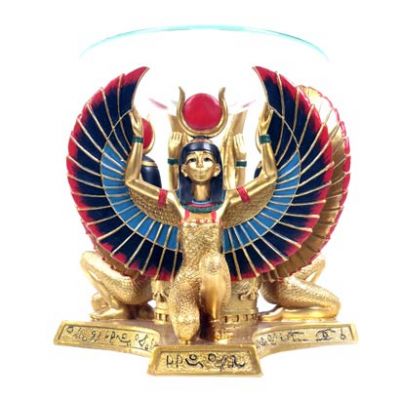
The Liberty Bell is an Isis bell, the fertile womb of Mystery Babylon. It's a symbol of the "liberty" that is independence from God. The Liberty Bell and the clock on the bell tower of Independence Hall signal America's fertile founding as a rebel's paradise.
Featured on the back of the Federal Reserve's one hundred dollar note is the clock tower of Independence Hall in Philadelphia, PA.
The Federal Reserve imprints their notes and coins with occult symbolism.
The great seal on the back of the one dollar note is famously adorned with occult symbolism. I've recently blogged about how coins have numeric features that make them particularly special when tossed into fountains. That Freemasonry and Luciferian illuminism is behind the imagery is well documented. The Independence Hall clock tower on the one hundred dollar note must be important. It was featured in the movie franchise "National Treasure" as a major plot device. The time displayed on the clock was a clue that had to be deciphered, concealed and revealed through the symbols of America and Freemasonry. When I consider the Independence Hall clock I perceive a clue that leads me to another kind of treasure!The clock on Independence Hall is a parable. Clocks serve to disassociate people from the natural ways that honor the Creator. Individuals and communities governed by clocks are disassociated, disconnected in their relationship with the Creator, thus operating independent of Him. The clock ... on Independence Hall - get it? The treasure here is insight into the truth behind what is meant by independence!
When most people see the word in that context, what comes to mind is obviously, "independence from Britain." Independence Hall in Philadelphia is the very place where the Declaration of Independence was signed in 1776. That document begins, "When in the Course of human events, it becomes necessary for one people to dissolve the political bands which have connected them with another..." There can be no doubt that independence meant the establishment of a nation independent of the British Empire. Beyond that lies a greater truth, one to which the clock bears witness; one that is difficult for some to accept. The clock testifies of a community of men who have rebelled against the rule of the Creator by replacing His provision for the governance of their activity with another. This, my friend, is precisely what Independence Hall stands for.
1) Let every soul be subject unto the higher powers. For there is no power but of God: the powers that be are ordained of God.
2) Whosoever therefore resisteth the power, resisteth the ordinance of God: and they that resist shall receive to themselves damnation.
3) For rulers are not a terror to good works, but to the evil. Wilt thou then not be afraid of the power? do that which is good, and thou shalt have praise of the same:
4) For he is the minister of God to thee for good. But if thou do that which is evil, be afraid; for he beareth not the sword in vain: for he is the minister of God, a revenger to execute wrath upon him that doeth evil.
5) Wherefore ye must needs be subject, not only for wrath, but also for conscience sake.
6) For for this cause pay ye tribute also: for they are God's ministers, attending continually upon this very thing.
7) Render therefore to all their dues: tribute to whom tribute is due; custom to whom custom; fear to whom fear; honour to whom honour.
Romans 13:1-7
There is no provision in Romans 13 for saints to declare independence from the British Empire. King George III was the higher power, ordained of God. If you read the Declaration of Independence with humility, the inescapable conclusion is that rebellion against the rule of King George III was rebellion against the sovereign God's appointed regent, and therefore against God's authority and God Himself!
The Declaration of Independence presumes through proud and lofty language to have a mandate for such action as was subsequently taken to secure such independence. "... it is their right, it is their duty, to throw off such Government, and to provide new Guards for their future security." There was no such mandate, biblically, but only in the minds of lawless and rebellious men, most of them Freemasons, deceived and deceivers.
According to Albert G. Mackey, on page 374 of the "Encyclopedia of Freemasonry, Part 1," you may read about the cornerstone for the State House (Later known as Independence Hall) being laid by Benjamin Franklin during his administration as Grand Master, with the Brethren of Philadelphia's St. John's Lodge, Libre B.
I must emphasize the need to honestly read the witness of the clock on Independence Hall so we're not deceived. America runs on Babylon time, which is GMT. How is that independent from the British Empire? Understand about the Liberty Bell. These icons of America declare its independence from our Creator while declaring its idolatrous dependence upon the gods of Babylon.
Consider this statement from usgovinfo.about.com.
"No matter how much we argue about the details of its meaning today, in the opinion of many, the Constitution signed in Philadelphia on September 17, 1787 represents the greatest expression of statesmanship and compromise ever written. In just four hand-written pages, the Constitution gives us no less than the owners' manual to the greatest form of government the world has ever known." Constitution Day To that I say shame on us if we buy into that bold and wickedly foolish rejection of the Creator's authority and governance.
Have you read Is Your God American? and been convicted by it? Those whose god is American are idolators. The time has come to repent of this and all idolatry. The time has come. This is my firm conviction.
See also The Judgment Has Begun by Joseph Herrin (09-17-2010)


