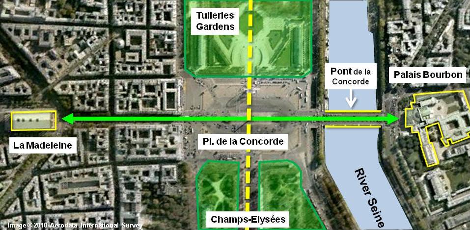
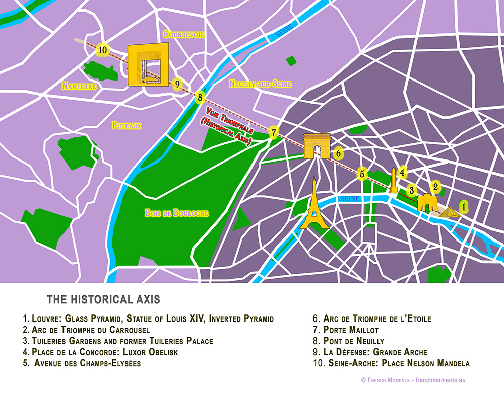
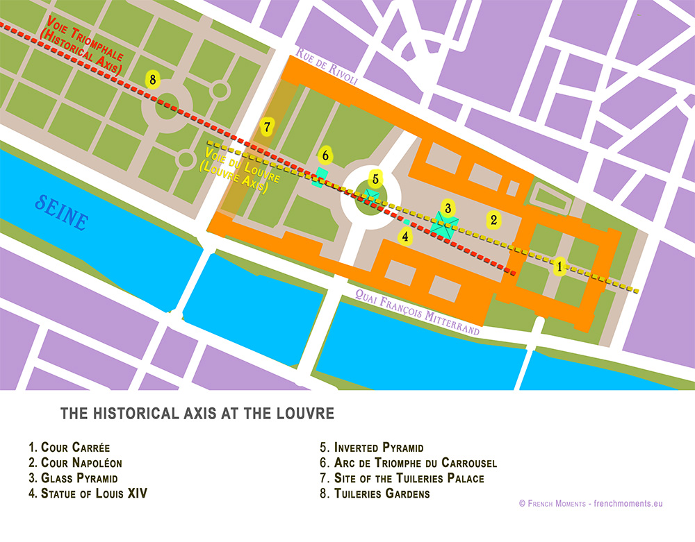
You may know Paris for its cathedral Notre-Dame, the Eiffel Tower, its café culture and its amazing museums and art galleries. The French capital is also famous for its fantastic perspective that runs from the Louvre to La Défense. This is the ‘Voie Triomphale’, aka the Historical Axis of Paris.
This line is one of the most prestigious perspectives in the world. In fact, its design has inspired cities such as Buenos Aires, Washington DC, New Delhi and Canberra. In this article, we’ll learn more about the Historical Axis of Paris. We’ll discover the stunning monuments and I reveal to you some stunning facts.
More than just a series of monuments placed along the axis, it seems that a complex symbolism was at work in the mind of the successive urban planners.
The Historical Axis runs through some of Paris’ most celebrated monuments and squares:
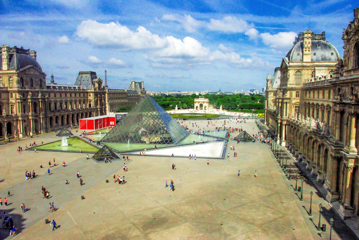
The Louvre: the Glass Pyramid, the equestrian statue of Louis XIV portrayed as ‘Alexander the Great’ in the Cour Napoléon, and the Inverted Pyramid.
The Seine-Arche project endeavours to push the axis beyond La Défense, to the Seine.
Let’s move along the Historical Axis of Paris, from East to West, starting from the Louvre.
The Palace of the Louvre
Today the great perspective starts at the Louvre, immediately beyond the Church of St Germain l’Auxerrois.
The crab-shaped Palace was the main residence of the kings of France until 1682, when Louis XIV, the ‘Sun King’, moved his court to Versailles. It currently houses one of the world’s most wonderful museums in a complex that is known as the “Grand Louvre”.
President François Mitterrand left his mark with his pharaonic project of “Le Grand Louvre”. He wished to complete it for the bicentennial celebration of the French Revolution in 1989. The titanic project comprised of major renovation works and the construction of a new landmark along the Historical Axis: the celebrated (and controversial) Glass Pyramid.
But if you look closer, you’ll notice that the glass pyramid is not aligned with the other monuments on the Historical Axis.
That’s why something had to be added in this vast courtyard of the Louvre…
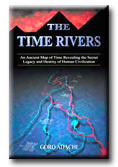
It’s about the discovery of an astounding system of literal ‘rivers of time’, which may even be described as the ‘fingerprints of the gods’. It is a planetary ‘Rosetta Stone’ for decoding history or even ‘reality’ itself. Sounds overly grandiose? Yes, but it’s not necessarily an exaggeration given the nature of the discovery.
Proving the existence of the ‘Time Rivers’ has explosive implications. And the claim here is that this has indeed been done. But that’s just the beginning of the story. What the ‘Time Rivers’ tell us - about who we are and everything else - is equally, if not more, profound.
The Time River Theory (TRT) is ultimately about the discovery and decoding of the ‘blueprint’ of reality - a blueprint that was literally carved on this planet by an unknown high intelligence. This is a brand new field just activated in 2003 via the publication of The Time Rivers. It’s about time we opened up the Gateway... to a new dimension.
To get a little more specific, here is an abbreviated list of what the Time River Theory is about and what it reveals (at least in the book The Time Rivers):
A grand system of literal ‘rivers of time’ flowing on our planet, created by some mysterious, higher intelligence.
The intricate ‘Time River scheme’ produced by the Nile, Tigris-Euphrates, Mississippi, etc. showing us the entire timeline of human civilization, both past and future.
Solutions to deep ancient mysteries of Egypt, Sumer, and even Mars.
Encoded ‘messages’ revealing extraterrestrial and/or extra-temporal origins of human civilization.
The 21st century being specifically pinpointed as the edge of time, when a ‘timegate’ opens up to bring mankind back to the realm of ‘Genesis’.
Tangible and unique solutions to the biblical events of Genesis such as Creation, the fallen angels, the Great Flood, the Ark, etc.
An encoded timeline of the United States anticipating ‘9/11’, an event suggested to mark the ‘end’ of the United States.
Please note that the the theory is extensive and still rapidly evolving, thus the above should be viewed as only the tip of the iceberg.
To learn more about the TRT, please see The Nile Decode - a paper posted online revealing the basic components of the thesis.
Current Status
A lot of very positive feedback has been received from those who have read The Time Rivers and/or The Nile Decoded. Some samples are posted here.
What about the reaction of the 'alternative history' crowd? How are they responding to the 'quantum leap' that the TRT would represent to their field? The answer to this question is not yet clear since the theory was revealed only recently and is not yet widely known. But the anticipation here is that the reaction would be more or less mixed. Because the Time River Theory is something that radically shifts the whole paradigm, there will probably be those in the field who are perhaps just too 'old' (at least mentally) to keep up with the sudden and rapid movement forward. And this is fine; the Time River system is a discovery for a new generation of truth seekers who maintain a fresh mind capable of clear and creative thinking.
There is actually so much more to the Time River scheme than made available so far (including the book), which is undoubtedly contributing to the tone of confidence expressed here. Hopefully there are many of you who can intuitively sense this 'energy' lurking just beneath the surface... It's all getting ready to come out now. If not already, please study the available material, understand the implications, and... well, join the revolution!
La Llama de la Libertad, ofrecida al pueblo francés por donantes de todo el mundo como símbolo de la amistad franco-americana, en la plaza Diana (París).
La Llama de la Libertad (en francés, Flamme de la Liberté) de París es una réplica del mismo tamaño de la nueva llama situada en el extremo de la antorcha que lleva en la mano la Estatua de la Libertad de Nueva York desde 1986.1 El monumento, que tiene aproximadamente 3,5 metros de longitud, es una escultura de una llama de cobre dorado, apoyada en un pedestal de mármol gris y negro. Está situado cerca del extremo norte del puente del Alma, en la plaza Diana, en el distrito 8 de París, Francia.2
Fue ofrecida a la ciudad de París en 1989 por el International Herald Tribune en nombre de los donantes, que habían contribuido aproximadamente 400 000 dólares para su realización. Representaba la culminación de las celebraciones de 1987 del periódico por su cien aniversario de la publicación de un periódico en inglés en París. Más importante, la Llama era una muestra de agradecimiento por la restauración de la Estatua de la Libertad realizada tres años antes por dos empresas francesas que hicieron el trabajo artesanal del proyecto: Métalliers Champenois, que hizo el trabajo del bronce, y Gohard Studios, que aplicó el pan de oro. Aunque el regalo a Francia fue motivado por el centenario del periódico, la Llama de la Libertad es un símbolo más general de la amistad que une los dos países, igual que la Estatua de la Libertad cuando fue regalada a los Estados Unidos por Francia.
Este proyecto fue supervisado por el director de la unión de artesanos franceses en aquel momento, Jacques Graindorge. Propuso la instalación de la Llama de la Libertad en una plaza pública llamada Place des États-Unis en el distrito 16, pero el alcalde de París, Jacques Chirac, se opuso a esto. Tras un prolongado período de negociaciones, se decidió que la alama se situaría en una zona abierta cerca de la intersección de la Avenue de New-York y la Place de l'Alma. El monumento fue inaugurado el 10 de mayo de 1989 por Chirac.
En la base del monumento hay una placa conmemorativa que relata la siguiente historia:
"La Llama de la Libertad. Una réplica exacta de la llama de la Estatua de la Libertad ofrecida al pueblo de Francia por donantes de todo el mundo como símbolo de la amistad franco-americana. Con ocasión del centenario del International Herald Tribune, París 1887-1987."
La llama se convirtió en un monumento no oficial de Diana de Gales después de su muerte en 1997 en el túnel bajo el Pont de l'Alma.3 La llama es una atracción para turistas y seguidores de Diana, quiens pegan pósteres y folletos con material conmemorativo en la base. El antropólogo Guy Lesoeurs dijo que "la mayoría de las personas que vienen aquí piensan que se construyó para ella."2 La plaza del monumento se llama desde entonces Plaza Diana (París).
El monumento está cerca de la estación del Metro de París llamada Alma-Marceau en la línea 9 y de la estación Pont de l’Alma Línea 'C' del RER, así como por los buses número 42, 63, 72, 80, 92, y los autobuses turísticos Balabus.
Timeline: June 18-24: Gov. Sanford missing/crying in Argentina June 21: 'Impact' Part 1 on ABC; Prince William birthday June 22: DC Metro Red Line trains in collision June 23: US Moon probes (LRO/LCROSS) reach Moon June 24: Gov. Sanford reveals Argentine affair June 25: Death of Michael Jackson & Farahh Fawcett
'Metro' means 'meter' in Spanish, Italian, Portuguese, etc. The meter is historically defined as 1/10,000,000 of the distance between the North Pole and the equator through Paris, or in other words the Paris Meridian between the North Pole and the equator. The Paris Meridian is also the 'Rose Line' (an esoteric concept popularized by The Da Vinci Code) i.e. a 'Red Line'...
DC Metro Red Line = French/Columbian Rose Line
...traditionally implying the Blood Royal/Sangraal or the Marian/Columbian Bloodline of the Holy Grail.
In Bloodline of the Holy Grail Laurence Gardner writes of the House of Stuart, the royal bloodline to which Princess Diana and her children belong (pp. 344-5):
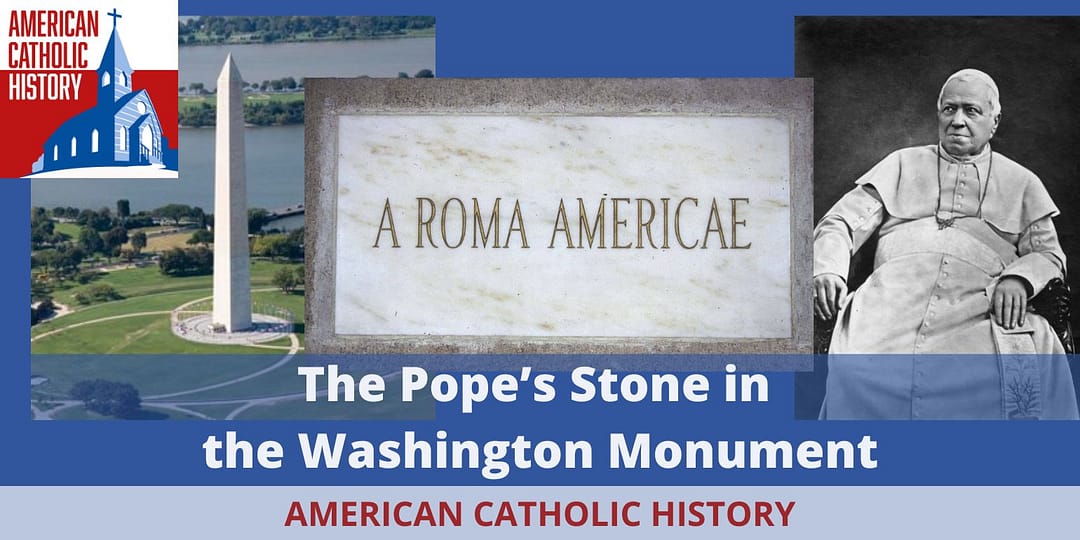
n 1854 a slab of marble donated by Pope Pius IX arrived in Washington, D.C. He had it engraved “A Roma Americae,” or “From Rome to America,” as a sign of goodwill. He had sent it over to be included in the Washington Monument, which was then under construction. Many foreign governments had sent similar contributions to honor America’s first president. The Know Nothings, however, had no intention of allowing a gift from the Pope to be included in the Washington Monument. They were certain the stone was a sign of darker intentions by the Pope. So on March 9, 1854, under cover of darkness, a group of these anti-Catholics broke into the yard, stole the stone, and after damaging it with hammers they dropped it in the Potomac River. No one was ever credibly accused of the crime, despite reward offers and a public outcry. Many years later, however, after a tip, the stone was discovered… only to disappear again. But today, there is a stone from the Pope in the Washington Monument, this one was provided by Pope John Paul II in 1982.
La estatua fue esculpida por Robert Berks en 19 trozos y luego se soldaron los trozos. Pesa 3.2 toneladas y mide 6.4 m de altura. La estatua se sienta en un banco de granito blanco de Washington D.C La estatua y el banco están en un lado de un estrado circular, de 8.5 metros de diámetro, hecho de granito de color esmeralda-perla de Larvik (Noruega). En el mismo estrado hay más de 2.700 tachones de metal que representan la ubicación de objetos astronómicos (el Sol, la Luna, los planetas, 4 asteroides, 5 galaxias, 10 quasares y muchas estrellas) como se veían al medioda del 22 de abril de 1979 cuando el monumento se inauguró. Los tachones tienen tamaños diferentes para denotar la magnitud aparente de los objetos relevantes, y otros tachones indican estrellas binarias, binarias espectroscópicas, púlsares, cúmulos globulares, cúmulos abiertos y quásares.
En los papeles sujetos por hcamila los importantes avances científicos de Einstein:
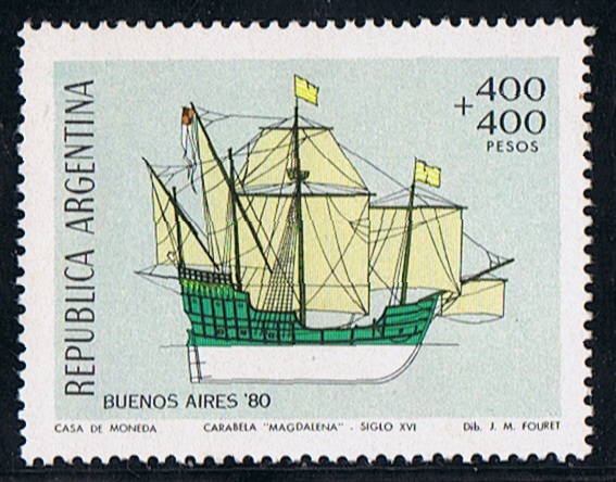
Not much is know about the caravel, where and when built unknown. Tonnage 200 ton, dim. 85 x 25 x 14ft. (draught) Four masts, fore and main mast square rigged, mizzen and Bonaventura mast lateen rigged.
She was the flagship of Don Pedro de Mendoza (1487-1537) expedition to the River Plata. Mendoza held a post in the court of Charles V, when he in 1534 made an offer to Emperor Charles V to make an expedition on his own account for the discovery and conquest of Paraguay and the countries on the Rio La Plata. 24 August 1534 Mendoza on board the MAGDALENA and 13 other vessels, with 3000 men set sail from San Lucar, Spain. Receive from the Emperor before sailing 2.000 ducats, with the condition, when he transported to the new founded colonies 1000 colonists and 100 horses, build a road to the Pacific Ocean, erect three forts within two years he would receive 2.000 ducats more. Also he had to take 8 monks, a physician, a surgeon, and an apothecary, but he was forbidden to introduce a lawyer in the colony. He was to have half the treasure of the chiefs killed and nine-tenths of the ransom. Mendoza was made before sailing military governor of all the territory between the Rio de la Plata and the Strait of Magellan. The office of the Governor was also made hereditary.
Off the coast of Brazil the fleet was scattered in a heavy storm, and Medoza lieutenant Osario, was assassinated, according to some authorities by the orders of Mendoza himself because of suspected disloyalty. 1535 Mendoza sailed up the Rio de la Plata, and founded Buenos Aires on 02 February 1536. He erected two forts there to defend the place. Pestilence broke out and the natives became unfriendly after ill treatment by the Spaniards. His brother Don Diego led a force against the hostile tribes, but was killed with three-fourths of his men. A general conspiracy of the natives was formed, and Buenos Aires was captured and burned by the natives. Mendoza retired to the forth Sanctus-Spiritus, from where he dispatched Juan de Ayolas to explore the upper part of the river. Another brother, Gonzalo arrived with reinforcements and founded the city of Ascención in Paraguay in 1536. Mendoza, disappointed and with a broken health, embarked on board the MAGDALENA for Spain in 1537, leaving Juan de Ayolas in charge. During the long voyage to Spain he died maniac on board the MAGDALENA on 23 June 1537.
Of the the famous Seven Wonders of the Ancient World the Great Pyramid of Khufu (Cheops) at Giza is the only one still standing. Even for modern men it is amazing how this man-made structure lasted so long.
The Giza pyramids must have made an incredible visual impact - at the edge of the desert three abstract geometrical symbols were rising, huge luminous white triangles reflecting the blinding light of the sun!
The pyramids on the Giza plateau are with 146.59m (Khufu / Cheops) and 143.87m (Khafre / Chefren) respectively the largest, however there are over 30 major pyramids and a myriad of smaller pyramids in Egypt.
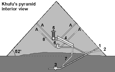
Cheops-Pyramid 1. Entrance 2. Entrance cut by grave robbers 3. Subterranean chamber 4. Grand Gallery 5. King's chamber, relieving chambers, granite portcullis slabs 6. Queen's chamber 7. Shaft 8. Limestone plugging the air shaft A= "Air shafts"
Khufu (Chuefui-Chnum or Khnum-Khuf, Cheops in Greek) during the 4th dynasty of the old kingdom
Time to build
Probably max. 23 years (Khufu reigned from2551 to 2528 before Christ *). Herodotus writes about 10 years of preparation and 20 years of building (details of the text)
Per day
With 2'500'000 stones 342 stones have to be moved daily (working during 365 days a year) or 431 stones daily (working during 290 days a year).
Per minute
10-hour day: every 2 minutes a stone (34 to 43 per hour) 8-hour day: nearly a stone every minute (42 to 53 stones per hour)
Rule of thumb
While construction the pyramid the rate of delivery was 1 stone weighting 2.5 tons every minute.
For our calculations we assume 500 stones a day. This is a rough estimate, assuming a 8-hour day, during 290 days a year, with 20 years to build the pyramid. Also assuming, that more time had to be used for the huge granite blocks for the King's chamber and for the more difficult upper part of the pyramid, where work went slower than in the lower parts. There probably were also other factors delaying the building of the pyramid such as the weather or a temporary shortage of certain building materials.
Building materials for the Cheops-pyramid
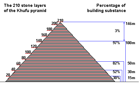
The Khufu-pyramid (Cheops) probably originally had 210 stone layers. At 50m height already 82% of the entire pyramid was built [3].
Originally probably 210 stone layers, now only 201 layers [2]
Stone size
The stone blocks usually are larger in the lower layers (1.5m = 3 cubit) and smaller in the upper layers. Most are between 1.5 and 2 cubit large (average of 127 x 127 x 71cm). 1 cubit = 0.524m - Details
Weight of the stone blocks
With an average density of 2,6 - 2,9 t/m³ the large limestone blocks weighted 6.5 - 10 tons and the smaller ones about 1.3 tons. For all calculations on this website an average weight of 2.5 tons was used.
Special blocks
For the King's chamber granite blocks weighting 40 to 50 tons were used
Total weight
6'500'000 tons (average weight of a block was about 2.5 tons)
Pyramidion
The final stone on the top was a large block in the shape of a pyramid. It was perhaps around 1.5m by 1.5m wide and 1.3m high (about 3 cubits). It was made from white Tura limestone (Turah), granite or perhaps diorite and perhaps gold plated. More information
Building materials
Pyramid: Nummulite limestone from quarries about 200-400m south of the pyramid were used for the core stones. Casing: light white limestone, so called Tura-limestone from quarries from the eastern shores of the Nile King's chamber: Rose granite from Aswan 900km away Further materials: Graywacke from the Wadi Hammamat (Eastern desert), basalt from the northern Faiyum Map of quarries in Egypt
Dimensions of the pyramid of Khufu
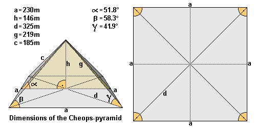
Length (a) -------------------
The average length of the edge is ~ 230.360m (230,12m = 440 cubits). Northern edge 230.328m - eastern edge 230.369m - southern edge 230.372m - western edge 230.372m. Largest difference is only 4.4cm. [3]
Height (h)
Originally 146.59m high (= 280 cubits), the pyramid is now only 138.75m high [7]
Diagonal (d)
325.77m
Ridge (g)
219m
Height of the lateral surface
186.42m
Pyramid angle α
51° 50' 40' = inclination of the lateral surface (= 52° rounded off) [3] which corresponds to a seked of 5½ palms
Pyramid angle β
58.3° = the two angles of the triangular lateral surface (62° = angle of the apex or tip of the pyramid) - nearly forming an equilateral triangle!
Pyramid angle γ
41.9° = angle of the ridge
Corner angle
Right angle base with angles from 89° 59' to 90°
Base area
53'065.73m²
Superficies surface
85'890.69m²
Pyramid volume
2'592'968.43m³ including the rock core. This would be a cube with a length of 137.38m. Probable volume of stones used: 2'583'283m³ [1] or 2'326'501m³ [2].
Alignment
Exactly to the north (deviation only 2' 28')
Latitude and longitude
N 29° 58’ 44.3830” latitude and E 31° 07’ 57.0194” longitude [5]
Altitude
The base of the pyramid of Khufu lies about 60m above sea level, so the tip of the pyramid used to be on 206m above sea level [6].
Dimensions of the pyramid of Khufu in Egyptian Royal Cubits
Length (a)
440 Royal Cubits
Height (h)
280 Royal Cubits
Height of the lateral surface (c)
356 Royal Cubits (356.09)
Diagonal (d)
622.25 Royal Cubits
Ridge (g)
418.56 Royal Cubits
Pyramid angle α
51.843°
Pyramid angle β
58.3°
Pyramid angle γ
41.9°
Corner angle
90°
It is suggested, that the Egyptians used a right angled triangle to determinate the angle of inclination of the pyramid, using the numbers a=11 and b=14 with c=17.8 (or a=22 - b=28 - c= 35.6). This determines a so called seked of 5½ palms. Alignment of the pyramids and controlling the shape of the pyramid (seked)
Sources
[1] M. Lehner The Complete Pyramids of Egypt [2] G. Goyon Die Cheops-Pyramide [3] R. Stadelmann Die grossen Pyramiden von Giza [4] F. Abitz Der Bau der grossen Pyramide mit einem Schrägaufzug [5] GPS-coordinates of a brass disk on top of the pyramid of Khufu, Giza Plateau Mapping Project (GPMP) [6] Maps of the Giza Plateau Mapping Project show the altitude as 60m [7] D. Arnold Building in Egypt
* Dates according to conventional Egyptian chronology are used in this website. These are based on several list of the dynasties of pharaohs, for example the Aegyptiaca of Manetho of Sebennytos.
47.6208°N 3.0482°W[41] A large dolmen measuring 12 by 5 m (39 by 16 ft), with a 5 m (16 ft) long broken capstone.[6] It is named after the nearby Chapelle de La Madeleine, which is still used.
Dolmen of Kercado. Though smaller than St. Michel, older by many centuries before 4800 BC.
A rare dolmen still covered by its original cairn. South of the Kermario alignments, it is 25 to 30 metres (82–98 ft) wide, 5 m (16 ft) high, and has a small menhir on top. Previously surrounded by a circle of small menhirs 4 m (13 ft) out,[39] the main passage is 6.5 m (21 ft) long and leads to a large chamber where numerous artifacts were found, including axes, arrowheads, some animal and human teeth, some pearls and sherds, and 26 beads of a unique bluish Nephrite gem. It has some Megalithic art carved on its inner surfaces in the form of serpentines and a human-sized double-axe symbol carved in the underside of its main roof slab. In ancient cultures, the axe and more precisely the bi-pennis used to represent the lightning powers of divinity. It was constructed around 4600 BC and used for approximately 3,000 years.[39]
(Pixies' mound or Grotte de Grionnec[39]):A group of three dolmens with layout unique in Brittany,[39] once covered by a tumulus. Whereas most groups of dolmens are parallel, these are arranged in a horseshoe. The largest of the three is at the east, 11 metres (36 ft).[38]
A "classic" dolmen, with a 40-tonne (44-short-ton), 7.6-metre (24 ft 11 in) tablestone resting on pillars roughly 1.8 m (5 ft 11 in) high. Prior to 1900, it was connected by a passage making it 24 m (79 ft) long.[39]
47.625°N 3.122°W: A classic 3, 4, 5 rectangle of 21 menhirs varying in height from 0.91 metres (3.0 ft) to 2.4 metres (7.9 ft) that is aligned along its diagonal to the midsummer sunrise. Alexander Thom suggested it measured forty by thirty of his megalithic yards.[43]
An arrangement of stones to form the perimeter of a large rectangle. Originally a "tertre tumulus" with a central mound, it is 37 m (121 ft) long, and aligned to east of northeast. The quadrilateral is 10 m (33 ft) wide to the east, but only 7 m (23 ft) wide at the west.[44]
47.603°N 3.056°W[45] Near the quadrilateral is a single massive menhir, now known as the "Giant". Over 6.5 m (21 ft) tall, it was re-erected around 1900 by Zacharie Le Rouzic,[39] and overlooks the nearby Kerlescan alignment.[46]
From the 1720s increasing interest was shown in these features.[47] In 1796, for example, La Tour d'Auvergne attributed them to druidic gatherings.[39] In 1805, A. Maudet de Penhoët claimed they represented stars in the sky.[39]
Englishmen Francis Ronalds and Alexander Blair made a detailed survey of the stones in 1834.[48] Ronalds created the first accurate drawings of many of them with his patented perspective tracing instrument, which were printed in a book Sketches at Carnac (Brittany) in 1834.[49]
The first extensive excavation was performed in the 1860s by Scottish antiquary James Miln (1819–1881), who reported that by then fewer than 700 of the 3,000 stones were still standing.[50] Towards 1875, Miln engaged a local boy, Zacharie Le Rouzic [fr] (1864–1939), as his assistant, and Zacharie learnt archaeology on the job. After Miln's death, he left the results of his excavations to the town of Carnac, and the James Miln Museum was established there by his brother Robert to house the artifacts. Zacharie became the director of the Museum and, although self-taught, became an internationally recognised expert on megaliths in the region. He too left the results of his work to the town, and the museum is now named Le Musée de Préhistoire James Miln – Zacharie le Rouzic.[51][52]
The Ménec alignments of some 1,100 stones in 11 columns
In 1887, H. de Cleuziou argued for a connection between the rows of stones and the directions of sunsets at the solstices.[39]
Among more recent studies, Alexander Thom worked with his son Archie from 1970 to 1974 to carry out a detailed survey of the Carnac alignments, and produced a series of papers on the astronomical alignments of the stones as well as statistical analysis supporting his concept of the megalithic yard.[51][53] Thom's megalithic yard has been challenged.[54][55]
There are also general theories on the use of the stones as astronomical observatories, as has been claimed for Stonehenge. According to one such theory, the massive menhir at nearby Locmariaquer was linked to the alignments for such a purpose.[15]
Sheep grazing around the Kerlescan alignment, part of a new management strategy
The Musée de Préhistoire James Miln – Zacharie le Rouzic is at the centre of conserving and displaying the artefacts from the area.[52] It also contains the "world's largest collection [of] prehistoric[al] exhibits"[38] with over 6,600 prehistoric objects from 136 different sites.
The monuments themselves were listed and purchased by the State at the start of the 20th century to protect them against quarrymen, and while this was successful at the time, in the middle of the century, redevelopment, changes to agricultural practices and increasing tourism bringing visitors to the stones led to rapid deterioration. The Ministère de la Culture et de la Communication (Heritage Ministry) re-examined the issue starting in 1984, and subsequently set up the 'Mission Carnac' in 1991 with the aim of rehabilitating and developing the alignments. This involved restricting public access, launching a series of scientific and technical studies, and producing a plan for conservation and development in the area.[56]
As with the megalithic structure of Stonehenge in England, management of the stones can be controversial. Since 1991, the main groups of stone rows have been protected from the public by fences "to help vegetation growth",[38] preventing visits except by organised tours. They are open during winter, however.[57] When James Miln studied the stones in the 1860s, he reported that fewer than 700 of the 3,000 stones were still standing, and subsequent work during the 1930s and 1980s (using bulldozers) rearranged the stones, re-erecting some, to make way for roads or other structures. In 2002, protesters invaded the site, opening the padlocks and allowing tourists free entry.[50] In particular, the group Collectif Holl a gevred (French and Breton for "the everyone-together collective") occupied the visitor centre for the Kermario alignment, demanding an immediate stop to current management plans and local input into further plans.[58]
In recent years, management of the site has also experimented with allowing sheep to graze among the stones, in order to keep gorse and other weeds under control.[59]
In June 2023, 39 menhirs still outside the UNESCO protected site were destroyed to construct a DIY store of the Mr. Bricolage franchise, which obtained a building permit from the local town hall in August 2022. The affected stones are located in the town of Montaubin, separate from the primary tourist locations of Ménec and Kermario, which are situated a little over 1.5km (1 mile) away. The town's mayor, Olivier Lepick, told AFP that he had "followed the law" and pointed to the "low archaeological value" of objects found during checks before the construction process began. He also admitted to being unaware that the site was listed on the Heritage Atlas, despite reportedly presiding over the group that applied for UNESCO status for the prehistoric sites. While Lepick blamed the region's complex zoning situation, the researcher Christian Obeltz claimed that "elected officials in the area and the department are in a hurry to build up anything because once it is classified with UNESCO, it won't be possible anymore". The local Koun Breizh association has decided to lodge a complaint with the public prosecutor of Vannes for willful destruction of sites that relate to archaeological heritage.[60][61][62][63]
Also interesting, Google Earth’s historical satellite pictures have shown that the monolith has been there since 2016. The monolith was in effect patiently waiting for years to be discovered at the “right time”.
Some people have already gone to the site using the coordinates yesterday and are apparently disappointed to discover that it looks more man-made than alien, as if that was the only issue.
As reader Atom commented:
What is really remarkable is the amount of attention it is getting and how it is intentionally or unintentionally pushing/triggering the ET theme into the public’s mind. I think we’ve never had anything like this ET-related in the MSM ever before. That’s quite something.
Here on Super Torch Ritual we are a bit different than most out there as we avoid focusing on the literal/surface level of anomalies and events. So while it’s nice to get these new details, they are not something that affects our multicontextual decoding, interpretations and projections. The Utah Monolith whispering…
+ – + – +
UPDATE – November 29
The Utah Monolith is gone! It’s not there anymore. ???????? Disappeared on the evening of November 27th.
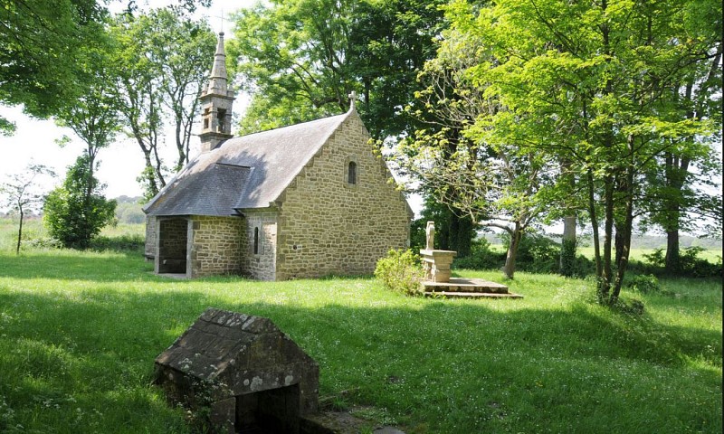
During your holidays in Carnac, discover the town’s religious heritage: its six chapels will take you on a journey through the centuries.
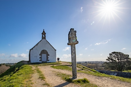
CHAPEL OF St Michel
The Chapel of Saint Michel de Carnac was rebuilt around 1813 and again in 1925 on the same plans as the original chapel dating from 1664. It is located on the highest point of the town, the tumulus hill. Below is St Michel devotional fountain. Women whose husbands were at sea, used to sweep the chapel in the direction they wanted to see the wind blow. Then they would to pray at the fountain and drink the water. St Michel’s saints day is in September. There is an orientation table at the high point of the hill.
Climb to the top of the tumulus and admire the breathtaking views of the ocean and islands.
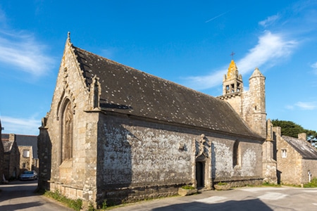
CHAPEL OF St Colomban
The Chapel of Saint Colomban, built in the flamboyant Gothic style, dates from the end of the sixteenth century. It is consecrated to the Irish monk Saint Columba, the patron saint of fools. To the east of the village, with its granite houses, is the fountain of Saint Colomban, which has two drinking pools. The wash house was a meeting place for the village women. South of the village, by the sea, are two chimneys, the remains of a forge.
The chapel is open all year round from 10 am to 6 pm. Entrance is free.
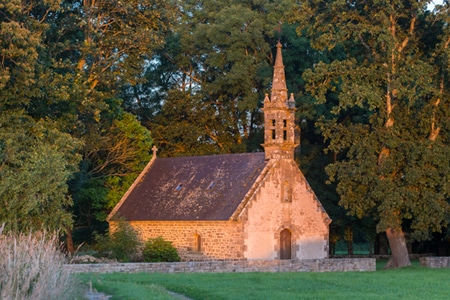
CHAPEL OF Kergroix
The Kergroix chapel dates back to the 16th century, although it was rebuilt in 1951. The Forgiveness of Our Lady of the Cross is celebrated in September. The chapel is open to the public all summer.
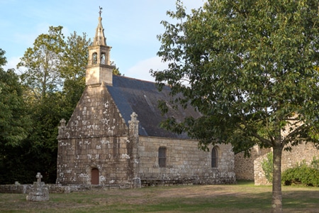
CHAPEL OF la Madeleine
The site of the chapel was once a leper colony. The present chapel was rebuilt in 1976. It is open and tended by local people in the summer. The most important service takes place in July. Next to the chapel, you will discover the fountain, the source of which is said to cure fever and skin diseases.
Continue your walk towards the Chapel of Hahon and the Chapel of Coet, both to the North of Carnac.
In the NW of France. Carnacs monuments date back to prehistoric times and are a popular tourist attraction. They provide insight into the ancient history, the neolithic age, and the culture of the region.
These monuments are among the most famous and extensive megalithic sites in the world, and are estimated to date back to the neolithic period.
More than 3,000 prehistoric standing stones were erected by the pre-Celtic people of Brittany They form the largest such collection in the world. (1)
From local granite, ancient ancestors, erected them Probably around 3300 BC but some may be as early as 4500BC. (2)
Different people have different stories Some associate the stones with 1st century AD romans, and later Christian occupations. Including that soldiers were turned to stone in pursuit of the pope. (3)(4)(5)
More commonly, local tradition claims. A legion was turned to stone by the popular wizard Merlin From King Arthur legend.
The questions of the carnac stones are still being debated.
Currently at, and around the main site. The 3 major groups of stone rows are: Ménec, Kermario and Kerlescan
Ménec alignments have eleven rows of menhirs. 1,165 by 100 metres; or 3,822 by 328 feet Some considered stone circles made at either end. Especially in the west. The largest stones are 13 feet or 4 meters. It lowers a bit in the middle and rises again in the extreme eastern end.
Kermario alignment is 10 columns. Spread about 1300 meters or 4300 feet long More of a fan like layout. 1029 stones are found in 10 columns. It is also believed a stone circle was here. In the east. Revealed by satellite photography. (6)
Kerlescan alignments is 13 lines. With total length around 800 meters (or, 2600 ft) A smaller group of 555 stones. Exists further to the east of the other two sites. The stones here also vary in size from about 80cm (or 2 foot 7 inches) to 4 meters, or 13 feet. (7)
Petit-Ménec alignments are much smaller and covered in the woods (8)
There are also three known tumuli They are: Carnacéen, Saint-Michel, Tumiac and Mané-er-Hroëk (9)
From the Carnac and Morbihan area. Carnacéen maybe around 7000 years old Containing a burial chamber, and one individual. Callaïs jewelry, stone arm rings and polished stone axe heads from the Italian alps were found too. Because jade is a hard stone. The axe heads 46 cm in length. Would have taken over one thousand hours to produce.
Saint-Michel is a tumulus constructed between around 7000 and 5400 years ago At its base it is 125 metres or 410 ft long; 50 metres (160 ft) wide; and, 10 metres or 33 ft high. (10). To produce. It required 35,000 cubic metres (46,000 cu yd) of stones and earth.
With its known neolithic and prehistoric significance. A chapel was built on top of the Tumulus in 1663 The current building is an identical reconstruction of the 1663 chapel, built in 1926.
Tumiac is known as Caesars mound because of its location as a observation tower during the Veneti war South of the Gulf of Morbihan. In 1853 archaeologists excavated a site, and carbon 14 dated it to 4790 or 4530 BC. The tumulus, elliptical and circular in shape. Is made of layers of clay. It is 50 meters wide; and, 15 meters in height. It contains several rectangular burial chambers. With monolithic supports and quartz slabs. It also had jadeite axes. Firbolite azes and callaïs beads.
Mané-er-Hroëk is a rectangular burial vault of about 5m by 3m. Covered with two slabs. On a 100x60mx8m mound Many stone axes, and jewelry including callaïs were found here. Its modern entrance is an addition.
There are dolmens in the area too They are: Er-Roc’h-Feutet, La madeleine, Kercado, Mané Brizil, Kerlescan, Mané-Kerioned, Crucuno and Crucuno stone rectangle
Er-Roc’h-Feutet An enormous cover stone covers the chamber, and the passageway still has its capstones. Near La Madeleine.
La Madeleine is 12x5m with a broken capstone
Kercado is almost 100 feet wide. It was previously surrounded by stone circle Down its 21 foot main passageway. Neophite gems, beads, human and animal teeth and numerous artifacts were found. Believed to be constructed around 4600 BC.
Mané Brizil
Kerlescan A roughly rectangular mound, with a capstone remaining, and entry from the south.
Kermarquer On a small hill, has two separate chambers.
Mané-Kerioned is a unique group of 3 dolmens. Once covered by a tumulus
Crucuno is a classic dolmen. 1.8 meter pillars supporting a 40 ton tablestone
Crucuno stone rectangle has 21 menhirs. From about 3 to 8 feet height
Other menhirs, and formations that do not fit into categories There’s also the manio quadrilateral, and manio giant
Manio quadrilateral, Is 121 feet long and 23-33 feet wide Believed to have a central mound. Or, originally be a “tertre tumulus”.
Manio giant is near the quadrilateral. A single massive menhir Over 6.5 m or 21 feet tall. It overlooks the Kerlescan alignment.
In 1796, La Tour d’Auvergne attributed the stones to druidic gatherings.
Others said they were stars or planetary formations. And, some that they were used for workouts, and team building exercises.
Did you know? In 1834 Englishmen Francis Ronalds and Alexander Blair drew them. In Sketches at Carnac (Brittany). A popular book for the time.
In the 1860s, extensive excavation was performed It was James Miln (1819–1881), a Scottish archaeologist and historian. He reported that fewer than 700 of the 3,000 stones were still standing, and that the sites should be further investigated. Eventually he engaged Zacharie Le Rouzic (1864–1939), a local boy, as his assistant.
The Musée de Préhistoire is now named in boths honour
Displaying the ‘largest collection of prehistoric exhibits’. Will over 6600 displays, from 136 sites.
The exact purpose and cultural significance of Carnacs megalithic monuments remain topics of scholarly study and debate. They’re a testament to the skills and beliefs of the prehistoric people who constructed them. It continues to attract tourists, and historians from around the world. Interested in understanding our historical and cultural significance.
Le site de la chapelle était autrefois une léproserie. La chapelle actuelle a été reconstruite en 1976. Une permanence est assurée l'été par les habitants du quartier. Le pardon a lieu en juillet. A côté de la chapelle, vous découvrirez sa fontaine, dont la source est recherchée pour guérir la fièvre et les maladies de peaux. A proximité le dolmen er-Roch-Feutet


 Flip
Flip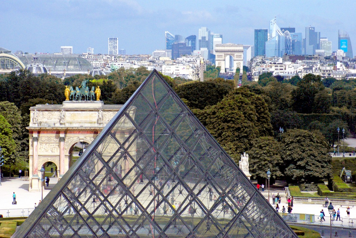


 A grand system of literal