Two hundred and fifty years ago this month, a young Scottish engineer took a Sunday walk across Glasgow Green – and changed the world. Thanks to the idea dreamed up by James Watt that Sunday in May 1765, human beings became masters of power generation and so transformed our planet.
At the time, Watt was merely fixated with the problems posed by the primitive and inefficient steam engines that were then being used to pump water from mines, and had already made several futile attempts to improve them. Then, on his Sunday walk, the idea for a new device – which he later called the separate condenser – popped into his mind.
It was a notion that would have stunning consequences. The separate condenser changed the steam engine from a crude and inefficient machine into one that became the mainstay of the industrial revolution. Britain was transformed from an agricultural country into a nation of manufacturers.
Today, many scientists believe the processes unleashed by Watt have begun to alter the physical makeup of our planet. After two-and-a-half centuries of spewing out carbon dioxide from plants and factories built in the wake of his condenser’s invention, the atmosphere and crust of the Earth are beginning to be transformed. Watt truly changed the world, it seems.
Indeed, that walk on Glasgow Green remains “one of the best recorded, and most repeated, eureka moments since Archimedes leaped out of his bathtub”, according to William Rosen in his book The Most Powerful Idea in the World: A Story of Steam, Industry and Invention, published in 2010.
In 1765, Watt – then an instrument-maker based at Glasgow University – was working on a Newcomen pump, a state-of-the-art device in which steam pushed a piston through a cylinder. Water was then sprayed into the cylinder, cooling it and causing the steam to condense, creating a vacuum behind the piston that sucked it back into its original position. More steam was pumped in and the piston was pushed forward again.
It was a very powerful process but also a very inefficient one. Constantly heating and then cooling the engine’s huge cylinder required huge amounts of heat and coal. Steam engines like these had only limited usefulness.
Then Watt set off on his walk. When he was halfway across the green, the idea of a separate condenser came into his mind. Such a device would, he realised, create a vacuum that would help suck in the engine’s piston but still allow its main cylinder to operate at a constant temperature. “I had not walked further than the golf-house when the whole thing was arranged in my mind,” he later recalled.
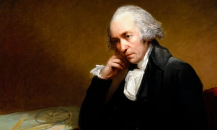
The earliest known portrait of James Watt, painted by Carl Fredrik von Breda in 1792. Photograph: SSPL via Getty ImagesWatt would have gone to work straight away but was constrained by the dictates of the Scottish sabbath. He quickly made a model of his device, nevertheless, and this is now displayed in the Science Museum in London. Four years later, he patented the condenser – and triggered the industrial revolution.
“Watt’s condenser tripled the efficiency of the steam engine and that meant that mill or mine owners got three times more mechanical work for every tonne of coal they had to buy,” says Colin McInnes, professor of engineering science at Glasgow University. “It meant that Britain’s coal stocks had been effectively trebled. He made a tremendous difference to the rate at which industry spread through Britain and subsequently the rest of the world.”
Until Watt, human enterprise was constrained by the process of photosynthesis, says McInnes. “In other words, we had to rely on natural living sources for the power we needed to run our factories or plants: fast-flowing water or horses or burning wood. By making the steam efficient, Watt changed all that. He gave us the means to exploit energy-dense fossil fuels in an effective manner. It changed the world and ended the era of renewable energy.”
This point is backed up by Ben Russell, curator of mechanical engineering at the Science Museum, and author of James Watt: Making the World Anew, published last year. “Before Watt, industry had to rely on water power, and there was a strict limit to the number of factories you could build on the banks of fast-flowing rivers,” he says.
“After Watt invented the separate condenser, you could build highly efficient factories almost anywhere you wanted. It made it possible to build plants that were driven by cheap, relatively easy sources: coal and steam. The cotton industry was transformed. So was brewing. And mining. Watt brought wide acceptance of steam as a power source.”
Within a few decades of Watt’s breakthrough, networks of factories and mines, linked by railways, were spreading across the country, triggering a national frenzy for fossil fuels that has since become a global obsession. Steam power no longer dominates global industry but our reliance on fossil fuels such as coal, oil and gas still lingers – with growing impacts on the planet.
Indeed, the Nobel-prizewinning chemist Paul Crutzen now argues that the greenhouse gases produced by burning fossil fuels have brought about such profound changes that we must accept the world has entered a new epoch. He calls it the “anthropocene”.
","alt":"How the condenser works","index":16,"isTracking":false,"isMainMedia":false}" data-island-status="hydrated" style="box-sizing: border-box;">According to Crutzen and many other scientists, the planet is no longer being shaped primarily by natural processes but by ones set loose by human beings. We are raising levels of carbon dioxide in the atmosphere, scarring the planet’s surface in our search for coal and metals, cutting down forests to make way for factories and homes, and acidifying the oceans. Humans have become planet changers.
As to the event that triggered this onslaught, there are few better candidates than Watt’s stroll across Glasgow Green 250 years ago – though for such a momentous event, it is still afforded remarkably little recognition.
Indeed, it was only relatively recently, in the 1980s, that Glasgow’s councillors decided to install a small boulder in what is Glasgow’s oldest park, with a simple inscription: “Near this spot in 1765, James Watt conceived the idea for the separate condenser for the steam engine.”
By contrast, a few metres away, a 40-metre obelisk dedicated to Horatio Nelson was erected in 1806, only a year after his death at Trafalgar. Thus a remote battle was celebrated with a grandiose monument while an invention that gave birth to the industrial revolution and changed the world had to wait almost two centuries for recognition – in the form of a small stone.
On the other hand, Watt’s striking achievement will be recognised on 5 June, when Glasgow University stages a seminar, The Invention that Changed the World, focusing on Watt and his revolutionary separate condenser, as part of the Glasgow Science Festival.
“Watt was a real product of the enlightenment,” says the seminar’s organiser Lesley Richmond, deputy director of Glasgow University’s archives. “He was self taught, yet went on to work at Glasgow University at a time when Adam Smith and Joseph Black were teaching there.
“He was far more than just the inventor of the separate condenser, though that was the device that was to have the greatest impact. He also invented a machine for copying documents, for example – an early photocopier, in effect.
“And there is so much we can still learn about him. Many of his devices and papers have still to be properly archived and studied. In 2019, we will mark the bicentenary of Watt’s death. By then, we want to have all his work in digital form. Then we will get a real chance to appreciate his fantastic achievements.”

