|
|
General: UTAH NORMANDY FRANCE MADELEINE SAINT MICHAEL VIKING 1 2
Scegli un’altra bacheca |
|
Rispondi |
Messaggio 1 di 23 di questo argomento |
|
|
|
|
|
Rispondi |
Messaggio 9 di 23 di questo argomento |
|
|
|
|
Rispondi |
Messaggio 10 di 23 di questo argomento |
|
D-DAY 1944 AND A FULL MOON.
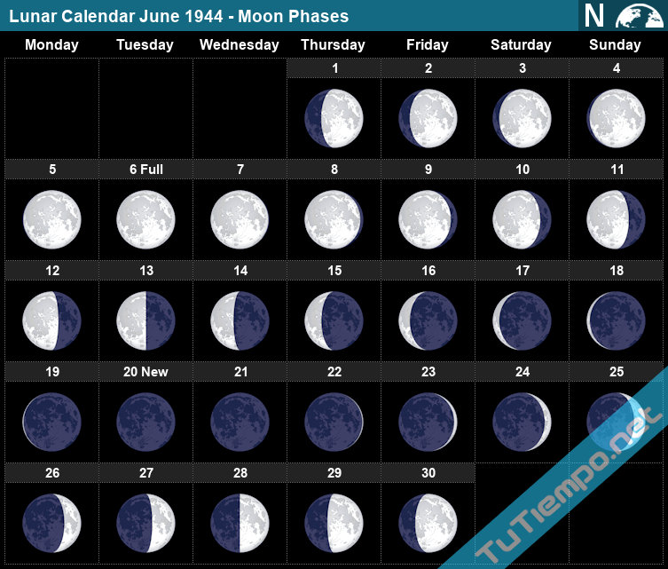
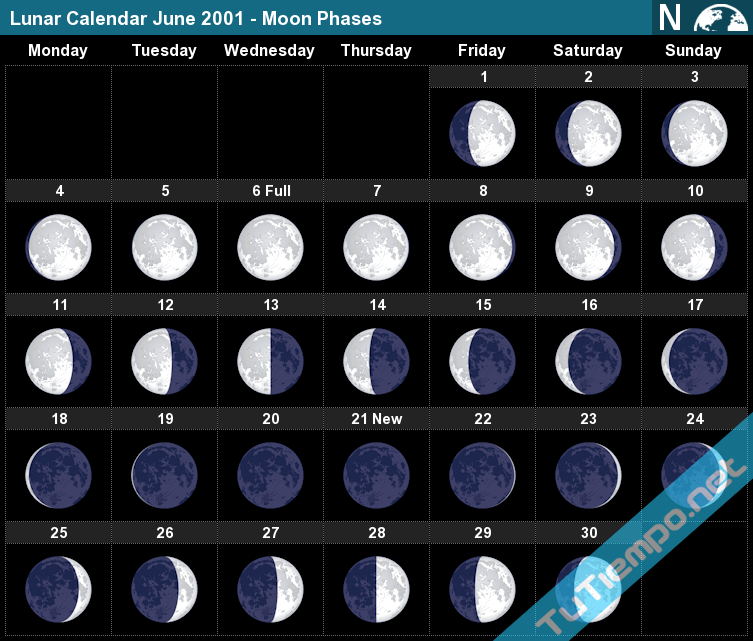
D-Day June 6, 1944 was very carefully timed to coincide with the moment of June’s Full Moon. It was reaching the highest point in the sky at 1:19 a.m. and just as the American airborne operations began. There was a Full Moon shining all night long in Normandy.
Why D-Day required a Full Moon.
As well as moonlight throughout the night, the tides were crucial, and that’s where a Full Moon really comes in. The Allies were able to use a low tide at 5:23 a.m. on D-Day to destroy the Germans’ underwater defenses at Omaha Beach.
But they also wanted rising water so that they could beach a craft and not get stranded.
If you want to have an insight into the conditions of the Normandy landings, 76 years ago, you could visit the invasion beaches of Normandy, France on June 5 and 6, when June’s Full Moon will shine all night long.
For those not able to be at the Normandy Beaches, you could experience an eerie feeling tonight, June 6, 2020 on our own beaches, when JUNE’s FULL MOON will SHINE ALL NIGHT LONG…….. REMEMBER D-DAY.
|
|
|
|
Rispondi |
Messaggio 11 di 23 di questo argomento |
|
|
|
|
Rispondi |
Messaggio 12 di 23 di questo argomento |
|
|
|
|
Rispondi |
Messaggio 13 di 23 di questo argomento |
|
|
|
|
Rispondi |
Messaggio 14 di 23 di questo argomento |
|
Biden conmemorará aniversario del Día D en Francia mientras alianzas occidentales enfrentan amenazas
El presidente estadounidense Joe Biden llega a Francia para el 80 aniversario del Día D, donde se unirá a otros líderes mundiales para conmemorar la invasión que ayudó a poner fin a la Segunda Guerra Mundial.
PARÍS —
El presidente de Estados Unidos, Joe Biden, conmemorará esta semana el 80 aniversario de la invasión del Día D en Francia, mientras intenta demostrar un firme apoyo a la seguridad europea en un momento en el que algunos aliados temen que Donald Trump amenace con poner en entredicho los compromisos estadounidenses si gana otro mandato en la Casa Blanca.
El viaje se produce mientras continúan los combates más letales en el continente desde la Segunda Guerra Mundial en Ucrania y los países aliados luchan por encontrar formas de cambiar el rumbo contra Rusia, que recientemente ha ganado terreno en el campo de batalla. También se produce en medio de las grietas cada vez más profundas entre Estados Unidos y muchos aliados europeos sobre cómo gestionar la actual guerra entre Israel y Hamás en Gaza.
Biden llegó a París el miércoles por la mañana y fue recibido por funcionarios franceses y una guardia de honor. El jueves, visitará un terreno sagrado cerca de las playas de Normandía, donde hileras de lápidas blancas marcan las tumbas de los soldados estadounidenses que murieron para poner fin a la Segunda Guerra Mundial. Biden también hablará el viernes en Pointe du Hoc, un lugar de la costa francesa donde los Rangers del ejército escalaron acantilados costeros para superar las defensas nazis.
El asesor de Seguridad Nacional de la Casa Blanca, Jake Sullivan, dijo a bordo del Air Force One camino a Francia que Biden enfatizará cómo los hombres en esos acantilados "pusieron al país por delante de ellos mismos" y detallará "los peligros del aislacionismo y cómo, si apoyamos a los dictadores y no nos enfrentamos a ellos, seguirán adelante y, en última instancia, Estados Unidos y el mundo pagarán un precio mayor".
"Ochenta años después, vemos a los dictadores una vez más intentando desafiar el orden, intentando marchar en Europa", dijo Sullivan, "y que las naciones amantes de la libertad necesitan unirse para oponerse a eso, como lo hemos hecho nosotros".
También dijo que Biden se reunirá con el presidente ucraniano Volodymyr Zelenskyy en Francia para discutir "cómo podemos continuar y profundizar nuestro apoyo a Ucrania".
El sábado, Biden y su esposa Jill serán honrados por el presidente francés Emmanuel Macron con una visita de Estado que incluirá un desfile militar en París y un banquete en el Palacio del Elíseo, así como sesiones de negocios en las que los líderes discutirán el fortalecimiento de su alianza, comercio y cooperación en materia de seguridad para los próximos Juegos Olímpicos.
También se espera que los dos líderes discutan sobre Medio Oriente. Biden ha invertido capital geopolítico en negociar un alto el fuego en la guerra entre Israel y Hamás que permitiría la liberación de rehenes, aunque ha mantenido su firme apoyo a Israel y se ha resistido a los esfuerzos europeos de reconocer un estado palestino o investigar a Israel por su manejo de la guerra.
https://www.vozdeamerica.com/a/biden-conmemorara-80-aniversario-dia-d-francia-alianzas-occidentales-enfrentan-amenazas-/7643479.html |
|
|
|
Rispondi |
Messaggio 15 di 23 di questo argomento |
|
Midnight in Paris
| Midnight in Paris |

Theatrical release poster
|
| Directed by |
Woody Allen |
| Written by |
Woody Allen |
| Produced by |
|
| Starring |
|
| Cinematography |
Darius Khondji |
| Edited by |
Alisa Lepselter |
Production
companies |
|
| Distributed by |
Sony Pictures Classics (United States)
Alta Films (Spain)[1] |
| Release dates |
- May 11, 2011 (Cannes)
- May 13, 2011 (Spain)
- May 20, 2011 (United States)
|
| Running time |
94 minutes[2] |
| Countries |
|
| Language |
English |
| Budget |
$17 million[1] |
| Box office |
$151.7 million[1] |
Midnight in Paris is a 2011 fantasy comedy film written and directed by Woody Allen. Set in Paris, the film follows Gil Pender (Owen Wilson), a screenwriter and aspiring novelist, who is forced to confront the shortcomings of his relationship with his materialistic fiancée (Rachel McAdams) and their divergent goals, which become increasingly exaggerated as he travels back in time to the 1920s each night at midnight.[3]
Produced by the Spanish group Mediapro and Allen's US-based Gravier Productions, the film stars Wilson, McAdams, Kathy Bates, Adrien Brody, Carla Bruni, Tom Hiddleston, Marion Cotillard, and Michael Sheen. It premiered at the 2011 Cannes Film Festival and was released in the United States on May 20, 2011.[3][4] The film opened to critical acclaim. In 2012, it won the Academy Award for Best Original Screenplay and the Golden Globe Award for Best Screenplay. It was nominated for three other Academy Awards: Best Picture, Best Director and Best Art Direction.[5]
In 2010, disillusioned screenwriter Gil Pender and his fiancée, Inez, vacation in Paris with Inez's wealthy parents. Gil, struggling to finish his debut novel about a man who works in a nostalgia shop, finds himself drawn to the artistic history of Paris, especially the Lost Generation of the 1920s, and has ambitions to move there, which Inez dismisses. By chance, they meet Inez's friend, Paul, and his wife, Carol. Paul speaks with great authority but questionable accuracy on French history, annoying Gil but impressing Inez.
Intoxicated after a night of wine tasting, Gil decides to walk back to their hotel, while Inez goes with Paul and Carol by taxi. At midnight, a 1920s car pulls up beside Gil and delivers him to a party for Jean Cocteau, attended by other people of the 1920s Paris art scene. Zelda Fitzgerald, bored, encourages her husband Scott and Gil to leave with her. They head to a cafe where they run into Ernest Hemingway and Juan Belmonte. After Zelda and Scott leave, Gil and Hemingway discuss writing, and Hemingway offers to show Gil's novel to Gertrude Stein. As Gil leaves to fetch his manuscript, he returns to 2010; the cafe is now a laundromat.
The next night, Gil tries to repeat the experience with Inez, but she leaves before midnight. Returning to the 1920s, Gil accompanies Hemingway to visit Gertrude Stein, who critiques Pablo Picasso's new painting of his lover Adriana. Gil becomes drawn to Adriana, a costume designer who also had affairs with Amedeo Modigliani and Georges Braque. Having heard the first line of Gil's novel, Adriana praises it and admits she has always longed for the past.
Gil continues to time travel the following nights. Inez grows jaded with Paris and Gil's constant disappearing, while her father grows suspicious and hires a private detective to follow him. Adriana leaves Picasso and continues to bond with Gil, who is conflicted by his attraction to her. Gil explains his situation to Salvador Dalí, Man Ray, and Luis Buñuel; as surrealists, they do not question his claim of coming from the future. Gil later suggests the plot of "The Exterminating Angel" to Buñuel.
While Inez and her parents travel to Mont Saint Michel, Gil meets Gabrielle, an antique dealer and fellow admirer of the Lost Generation. He later finds Adriana's diary at a book stall, which reveals that she was in love with Gil and dreamed of being gifted earrings before making love to him. To seduce Adriana, Gil tries to steal a pair of Inez's earrings but is thwarted by her early return to the hotel room.
Gil buys new earrings and returns to the past. After he gives Adriana the earrings, a horse-drawn carriage arrives, transporting them to the Belle Époque, an era Adriana considers Paris's Golden Age, they go to the Moulin Rouge where they meet Henri de Toulouse-Lautrec, Paul Gauguin, and Edgar Degas, who all agree that Paris's best era was the Renaissance. Adriana is offered a job designing ballet costumes; thrilled, she proposes to Gil that they stay, but he, observing the unhappiness of Adriana and the other artists, realizes that chasing nostalgia is fruitless because the present is always "a little unsatisfying." Adriana decides to stay, and they part ways.
Gil rewrites the first two chapters of his novel. He retrieves his draft from Stein, who praises his rewrite. Still, he says that on reading the new chapters, Hemingway does not believe that the protagonist does not realize that his fiancée, based on Inez, is having an affair with the character based on Paul. Gil returns to 2010 and confronts Inez, who admits to sleeping with Paul but disregards it as a meaningless fling. Gil breaks up with her and decides to move to Paris. The detective following him takes a "wrong turn" and ends up being chased by the palace guards of Louis XVI just before a revolution breaks out. While walking by the Seine at midnight, Gil encounters Gabrielle. As it begins to rain, he offers to walk her home and learns that they share a love for Paris in the rain.
Main cast
|
|
|
|
Rispondi |
Messaggio 16 di 23 di questo argomento |
|
|
|
|
Rispondi |
Messaggio 17 di 23 di questo argomento |
|
|
|
|
Rispondi |
Messaggio 18 di 23 di questo argomento |
|
THE NAZI HUNT FOR HOLY TREASURE FROM THOR'S HAMMER TO THE HOLY GRAIL
Heinrich Himmler was infected by a virulent strain of spiritualism which fed into his racist, supremacist world view and drove him to search for holy relics.
The Holy Grail depicted on a stained glass window at Quimper Cathedral | CC BY-SA 3.0)
Lost Relics of the Knights Templar sees treasure hunters Carl Cookson and Hamilton White embark on a global odyssey. Their objective: to trace the past of a hoard of artefacts which may have once belonged to the Templars. One of their destinations is Wewelsburg, the imposing German castle which served as the spiritual sanctum for Heinrich Himmler and the SS.
Today, the castle is a looming reminder of how so many members of the Third Reich were beguiled by ancient myths, old orders of chivalry, and the occult. We all know the pantomime villain Nazis of the Indiana Jones films, desperate to dig up the Ark of the Covenant and the Holy Grail. But the fact is, many real-life Nazis were just as obsessed as their cackling silver screen counterparts.
Himmler in particular was infected by a virulent strain of spiritualism which fed into his racist, supremacist world view. For him, establishing a new Aryan empire meant resurrecting ancient Germanic myths and iconography. He believed the war against the lesser races required the overturning of traditional Christian morality, replacing it with a new kind of pseudo-religion that drew on chivalry and mysticism.
The now-notorious insignia of the SS, resembling two lightning bolts, was based on runes devised by an Austrian occultist and pagan called Guido von List. The SS itself was, in Himmler’s mind, an elite organisation in the tradition of the Teutonic Knights – an order which, like the Templars, came into existence during the Crusades. Himmler’s grand scheme was to establish Wewelsburg Castle as the Camelot of his modern-day knights. One of the rooms was even named after King Arthur, while another was designated the ‘Grail Room’.
Despite his aversion to conventional Christianity, Himmler was fascinated by the legend of the Grail, perhaps seeing it as a source of immense power. After all, he believed that another fabled artefact – Thor’s hammer – could be requisitioned as a weapon by the Third Reich. In an outlandish letter to the Ahnenerbe, a think tank set up to give academic backing to Nazi racial ideology, Himmler stated his belief that Thor’s hammer was ‘an early, highly developed war weapon of our forefathers’. For this reason, Himmler demanded that Ahnenerbe’s team should ‘find all places in the northern Germanic Aryan cultural world where an understanding of the lightning bolt, the thunderbolt, Thor's hammer, or the flying or thrown hammer exists’.
Himmler personally embarked on a failed mission to find the Holy Grail in 1940, visiting an abbey perched within the Montserrat mountain range in Catalonia. He was presumably led there by the belief that Montserrat was the real-life ‘Montsalvat’, location of the Grail in an Arthurian opera by Hitler’s favourite composer, Richard Wagner. This opera, Parsifal, was based on a medieval German poem called Parzival, written by a knight named Wolfram von Eschenbach. And this poem had already been an inspiration to another Grail hunter in the Nazi regime: Otto Rahn.
Rahn was a somewhat eccentric medievalist who believed there was a link between the story of Parzival and Catharism – a movement that flourished in medieval Europe, particularly in France. Condemned as heretics by the Catholic Church, the Cathars revived old Gnostic concepts that radically overturned traditional Christian thinking. They believed, for example, that the God of the New Testament and the God of the Old Testament were separate entities – the latter sinful, and the former good. Such ideas led to a crusade against the Cathars, and their wholesale slaughter.
A major Cathar stronghold was Montségur, a remote fortress in southwestern France. This became the site of a dramatic confrontation between the Cathars and French royal forces in 1243. Thousands of French troops besieged the fortress for nine long and gruelling months before the people inside eventually surrendered. Hundreds of Cathars were burnt alive in a bonfire after refusing to renounce their blasphemous beliefs. However, it’s believed that a number of Cathars managed to smuggle themselves out of the fortress, undetected, before their brethren surrendered.
It’s been speculated that these survivors of the siege took some kind of treasure with them. Gold, perhaps. Or maybe even the Holy Grail itself, brought back to Europe from the Holy Land, by the Templars or other Crusaders. Otto Rahn, prompted by previous occultists and mystics, identified Montségur with the ‘Montsalvat’ Grail castle of Parzival. His ideas appealed greatly to Himmler, and Rahn eventually joined the SS himself.
The extent of Rahn’s own Nazi beliefs have been a subject of debate. He himself apparently said, ‘A man has to eat. What was I supposed to do? Turn Himmler down?’ But having such powerful patronage certainly spurred him on to publish more about the Grail, with the SS brazenly inserting anti-Semitic passages into his romantic, mystical prose. Rahn eventually resigned from the SS and died of exposure on a mountain in 1939 – allegedly suicide, though the details have never been confirmed.
Colourful theories regarding the Cathars, the Grail and the potential involvement of Crusader warriors have persisted in the decades after the fall of the Third Reich. Most famously, in The Holy Blood and the Holy Grail, which theorised that the Cathars knew the secret of the Holy Grail – namely, that it was the bloodline of Christ, from the marriage of Jesus and Mary Magdalene. This concept fuelled the plot of Dan Brown’s bestseller The Da Vinci Code, which also portrays the Templars as guardians of this earth-shaking secret.
Carl Cookson and Hamilton White may not have a fabled holy relic in their hoard, but their quest may well bring new insights into the Templars and their religious treasure hunts in the Holy Land, which has fascinated everyone from eccentric occultists to high-ranking Nazis to serious historians today.
https://www.history.co.uk/shows/lost-relics-of-the-knights-templar/the-nazi-hunt-for-holy-treasure-from-thor-s-hammer-to-the-holy-grail |
|
|
|
Rispondi |
Messaggio 19 di 23 di questo argomento |
|
|
|
|
Rispondi |
Messaggio 20 di 23 di questo argomento |
|
|
|
|
Rispondi |
Messaggio 21 di 23 di questo argomento |
|
|
|
|
Rispondi |
Messaggio 22 di 23 di questo argomento |
|
Ritual de Tránsito 2012
Venus, Enterprise y la Puerta del Dragón
Por Goro
(goroadachi.com y supertorchritual.com)
25 de mayo de 2012

Del 4 al 6 de junio de 2012 , probablemente veremos al miembro más antiguo de la flota de transbordadores espaciales, el Enterprise , siendo remolcado río Hudson hasta su lugar de descanso final, el Museo Intrepid del Mar, el Aire y el Espacio, en el West Side de Manhattan . [Actualización: Fechas cambiadas al 3-6 de junio ]. La mayoría lo desconoce por completo, pero será un reflejo terrestre del Tránsito de Venus que tendrá lugar simultáneamente en el cielo los días 5 y 6 de junio. Todo cuidadosamente organizado para crear un ejemplo exquisito de "como es arriba, es abajo"...


Cuando esto ocurra, el Enterprise entrará en el río Hudson por su desembocadura en el extremo sur de Manhattan, donde podremos visualizar una "puerta" flanqueada por la Estatua de la Libertad y el World Trade Center , donde antiguamente se alzaban las Torres Gemelas . La disposición refleja nítidamente la puerta celestial alrededor del Anticentro Galáctico , flanqueada por las constelaciones de Orión y Géminis . La Vía Láctea es un río (celestial) como el Hudson ; Orión es un " portador de antorcha " (el Sol del solsticio de verano = antorcha de Orión) como la Estatua de la Libertad ; y Géminis son los " Gemelos ", como las Torres Gemelas .
El Sol arriba, la Enterprise abajo. A través de una puerta galáctica arriba, a través de una puerta Hudson abajo. Es un espejo que une el cielo y la tierra.

Para retroceder un poco en el tiempo, el "ritual" comenzó el 27 de abril cuando Enterprise voló hacia la Gran Manzana montado sobre un Boeing 747 precisamente cuando Venus alcanzó su " mayor brillo " como Estrella Vespertina. La coincidencia implicaba una conciencia subyacente del próximo Tránsito de Venus, que será el momento de menor brillo cuando Venus se convierta en un punto negro en la cara del Sol (5 y 6 de junio) sin luz solar reflejada hacia la Tierra.
Como muestra el gráfico, Venus se está atenuando cada vez más, lo que continuará hasta principios de junio. Tras el tránsito, Venus renacerá como el
ACTUALIZACIÓN 27 de mayo: El pico en el otro lado, a mediados de julio, coincidirá aproximadamente con el debut del Enterprise en el museo Intrepid como exhibición oficial, completando su correlación con la línea de tiempo de Venus:
----- fin de actualización -----
Como saben los lectores habituales, cuando hablamos de Venus, y en particular de la Estrella de la Mañana, también nos referimos automáticamente al Príncipe Guillermo y/o a la trinidad William-Kate-bebé. Ambos van de la mano, profundamente entrelazados, como ya se ha explicado en numerosas ocasiones. Por lo tanto, no sorprende que la cronología más reciente de Venus coincida perfectamente con la de la Familia Real Británica: el 29 de abril (máximo brillo de Venus) marcó el primer aniversario de la Boda Real; del 3 al 7 de junio (tránsito de Venus/Enterprise) se celebra el cumpleaños oficial de la Reina (4 de junio) y el Jubileo de Diamante ( 4-7, 3-5 de junio); el solsticio de verano (antorcha de Orión) coincide con el cumpleaños del Príncipe Guillermo; y a finales de julio (bajo una Estrella de la Mañana/portadora de luz muy brillante), la Antorcha Olímpica llega a Londres para los Juegos Olímpicos de 2012.
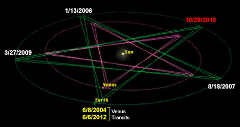
En términos de la órbita de la Tierra alrededor del Sol, el 27 de abril (la llegada del Enterprise a la Gran Manzana ) fue una ventana con el ápice de un pentagrama (núcleo de la manzana)...


El pentagrama es una firma geométrica de Venus, lo que tiene mucho sentido en el contexto actual.
Y la manzana tiene el efecto adicional de recordar a la Familia Real Británica a través del Rey Arturo , cuyo Santo Grial ( San Greal ) o "Sangre Real" ( Sang Real ) es de vital importancia para la realeza en Gran Bretaña. El linaje jacobita del Príncipe Guillermo y su futuro hijo tiene mucho que ver con el tema subyacente de este período, es decir, el "Regreso/Renacimiento del Rey Arturo", intercambiable con la "Resurrección de Lucifer/Fénix" , etc. (Consulte mi artículo " El Destino de Lucifer " para más información sobre el tema). Si el Rey Arturo ha de "regresar", sería desde Ávalon , donde se cree que el antiguo y futuro Rey hiberna. Resulta que el nombre "Ávalon" significa " manzana ".

También cabe destacar que la corte del Rey Arturo se llamaba Camelot , apodo popular de la administración de John F. Kennedy . El 27 de abril , el Enterprise aterrizó en el Aeropuerto Internacional JFK de Nueva York .

https://www.goroadachi.com/etemenanki/transit_ritual_2012.html |
|
|
|
Rispondi |
Messaggio 23 di 23 di questo argomento |
|
|
MOON PHASE TUESDAY JUN 6TH 1944 FULL MOON MADELEINE NORMANDY FRANCE
WHY CRESCENT MOON JUNE 22TH (MARADONA HAND OF GOD)?
|
|
|
|
|
|
 Primo Primo
 Precedente
9 a 23 de 23
Successivo Precedente
9 a 23 de 23
Successivo
 Ultimo

|
|
| |
|
|
©2025 - Gabitos - Tutti i diritti riservati | |
|
|


