|
|
General: MARK 2:27=MARY MAGDALENE S DAY=SABBATH (SATURDAY)=TIME TRAVEL SPACE =APOLLO 11
Elegir otro panel de mensajes |
|
|
CLEOPHAS/LEO/LEONARDO DA VINCI/LEON DE LA TRIBU DE JUDA/DAVID
C=LUNA CRECIENTE
|
|
|
|
|
John 1:1-2:1 symbolize the first week of creation which ended on the 7th day with the wedding of Adam and Eve. John's week ends with the wedding in Cana.
| Day #1 |
1:23-28 "This was the witness of John, when the Jews sent to him priests and Levites from Jerusalem..." "This happened at Bethany, on the far side of the Jordan, where John was baptizing." |
| Day #2 |
1:29-34 "The next day..." "I have seen and I testify that he is the Son of God." |
| Day #3 |
1:35-42 "The next day..." "You Simon son of John; you are to be called Cephas-which means Rock." |
| Day #4 |
1:43-51 "The next day..." "...you will see heaven open and the angels of God ascending and descending over the Son of man." |
| Day #5-6 |
|
| Day #7 |
2:1 "On the third day"...[from the last day which was day 4] there was a wedding at Cana in Galilee." |
Michal Hunt, Copyright © 2003 Agape Bible Study. Permissions All Rights Reserved.
Jesus identifies Himself with the significant and symbolic words: I AM, ego ami, which reminds us of Yahweh's revelation of Himself to Moses3 times as I AM in Exodus 3:13-14. In John's Gospel Jesus will use these words 26 times and in 7 different metaphors [each used with a predicate nominative]:
| 1. 6:35 |
"I AM the bread of life" |
| 2. 8:12 |
"I AM the light of the world" |
| 3. 10:7 |
"I AM the gate for the sheep" |
| 4. 10:11 |
"I AM the good shepherd" |
| 5. 11:25 |
"I AM the resurrection and the life" |
| 6. 14:6 |
"I AM the way and the truth and the life" |
| 7. 15:1 |
"I AM the true vine" |
Michal Hunt, Copyright © 2003 Agape Bible Study. Permissions All Rights Reserved.
St. John will also record four "I AM" statements in which Jesus does not use a predicate nominative:
| "I AM" with predicate nominative |
"I AM" without predicate nominative |
| 1. 6:35 |
"I AM the bread of life" |
1. 8:24 |
"...if you do not believe that I AM, you will die in your sins." |
| 2. 8:12 |
"I AM the light of the world" |
2. 8:28 |
When you have lifted up the Son of man, then you will know that I AM (He)* |
| 3. 10:7 |
"I AM the gate for the sheep" |
3. 8:58 |
"In all truth (Amen, amen) I tell you, before Abraham ever was, I AM." |
| 4. 10:11 |
"I AM the good shepherd" |
4. 13:19 |
"I tell you this now, before it happens, so that when it does happen you may believe that I AM (He)*" |
| 5. 11:25 |
"I AM the resurrection and the life" |
|
| 6. 14:6 |
"I AM the way and the truth and the life" |
|
| 7. 15:1 |
"I AM the true vine" |
|
|
|
|
|
|
Viking 1
This article is about the mission to Mars. For other uses, see Viking One.
Viking 1

Viking orbiter
|
| |
| Mission type |
Mars Orbiter/Lander |
| Operator |
NASA |
| COSPAR ID |
|
| SATCAT no. |
- Orbiter: 8108
- Lander: 9024
|
| Website |
Viking Project Information |
| Mission duration |
Orbiter: 1,846 days (1797 sols)
Lander: 2,306 days (2,245 sols)
Launch to last contact: 2,642 days |
| |
| Manufacturer |
Orbiter: JPL
Lander: Martin Marietta |
| Launch mass |
3,530 kg[a] |
| Dry mass |
Orbiter: 883 kg (1,947 lb)
Lander: 572 kg (1,261 lb) |
| Power |
Orbiter: 620 W
Lander: 70 W |
| |
| Launch date |
21:22, August 20, 1975 (UTC)[2][3] |
| Rocket |
Titan IIIE/Centaur |
| Launch site |
LC-41, Cape Canaveral |
| Contractor |
Martin Marietta |
| |
| Last contact |
November 11, 1982[4] |
| |
| Reference system |
Areocentric |
| Eccentricity |
0.88221 |
| Periareion altitude |
320 km (200 mi) |
| Apoareion altitude |
56,000 km (35,000 mi) |
| Inclination |
39.3° |
| Period |
47.26 hours |
| Epoch |
August 7, 1980 |
| |
| Spacecraft component |
Viking 1 Orbiter |
| Orbital insertion |
June 19, 1976[2][5] |
| Spacecraft component |
Viking 1 Lander |
| Landing date |
July 20, 1976[2]
11:53:06 UTC (MSD 36455 18:40 AMT) |
| Landing site |
 22.27°N 312.05°E[2] 22.27°N 312.05°E[2] |

|
Viking 1 was the first of two spacecraft, along with Viking 2, each consisting of an orbiter and a lander, sent to Mars as part of NASA's Viking program.[2] The lander touched down on Mars on July 20, 1976, the first successful Mars lander in history. Viking 1 operated on Mars for 2,307 days (over 61⁄4 years) or 2245 Martian solar days, the longest extraterrestrial surface mission until the record was broken by the Opportunity rover on May 19, 2010.[6]
Following launch using a Titan/Centaur launch vehicle on August 20, 1975, and an 11-month cruise to Mars,[7] the orbiter began returning global images of Mars about five days before orbit insertion. The Viking 1 Orbiter was inserted into Mars orbit on June 19, 1976,[8] and trimmed to a 1,513 x 33,000 km, 24.66 h site certification orbit on June 21. Landing on Mars was planned for July 4, 1976, the United States Bicentennial, but imaging of the primary landing site showed it was too rough for a safe landing.[9] The landing was delayed until a safer site was found,[9] and took place instead on July 20,[8] the seventh anniversary of the Apollo 11 Moon landing.[10] The lander separated from the orbiter at 08:51 UTC and landed at Chryse Planitia at 11:53:06 UTC.[11] It was the first attempt by the United States at landing on Mars.[12]
The instruments of the orbiter consisted of two vidicon cameras for imaging, an infrared spectrometer for water vapor mapping, and infrared radiometers for thermal mapping.[13] The orbiter primary mission ended at the beginning of solar conjunction on November 5, 1976. The extended mission commenced on December 14, 1976, after solar conjunction.[14] Operations included close approaches to Phobos in February 1977.[15] The periapsis was reduced to 300 km on March 11, 1977.[16] Minor orbit adjustments were done occasionally over the course of the mission, primarily to change the walk rate — the rate at which the areocentric longitude changed with each orbit, and the periapsis was raised to 357 km on July 20, 1979. On August 7, 1980, Viking 1 Orbiter was running low on attitude control gas and its orbit was raised from 357 × 33,943 km to 320 × 56,000 km to prevent impact with Mars and possible contamination until the year 2019. Operations were terminated on August 17, 1980, after 1,485 orbits. A 2009 analysis concluded that, while the possibility that Viking 1 had impacted Mars could not be ruled out, it was most likely still in orbit.[17] More than 57,000 images were sent back to Earth.
 Viking Viking aeroshell
The lander and its aeroshell separated from the orbiter on July 20 at 08:51 UTC. At the time of separation, the lander was orbiting at about 5 kilometers per second (3.1 miles per second). The aeroshell's retrorockets fired to begin the lander de-orbit maneuver. After a few hours at about 300 kilometers (190 miles) altitude, the lander was reoriented for atmospheric entry. The aeroshell with its ablative heat shield slowed the craft as it plunged through the atmosphere. During this time, entry science experiments were performed by using a retarding potential analyzer, a mass spectrometer, as well as pressure, temperature, and density sensors.[13] At 6 km (3.7 mi) altitude, traveling at about 250 meters per second (820 feet per second), the 16 m diameter lander parachutes deployed. Seven seconds later the aeroshell was jettisoned, and eight seconds after that the three lander legs were extended. In 45 seconds, the parachute had slowed the lander to 60 meters per second (200 feet per second). At 1.5 km (0.93 mi) altitude, retrorockets on the lander itself were ignited and, 40 seconds later at about 2.4 m/s (7.9 ft/s), the lander arrived on Mars with a relatively light jolt. The legs had honeycomb aluminum shock absorbers to soften the landing.[13]
Duration: 1 minute and 32 seconds.1:32Documentary clip recounting the Viking 1 landing with animation and video footage of the control centre
The landing rockets used an 18-nozzle design to spread the hydrogen and nitrogen exhaust over a large area. NASA calculated that this approach would mean that the surface would not be heated by more than one 1 °C (1.8 °F), and that it would move no more than 1 millimeter (0.04 inches) of surface material.[11] Since most of Viking's experiments focused on the surface material a more straightforward design would not have served.[18]
The Viking 1 lander touched down in western Chryse Planitia ("Golden Plain") at 22.697°N 312.05°E[2][11] at a reference altitude of −2.69 kilometers (−1.67 mi) relative to a reference ellipsoid with an equatorial radius of 3,397 kilometers (2,111 mi) and a flatness of 0.0105 (22.480° N, 47.967° W planetographic) at 11:53:06 UTC (16:13 local Mars time).[18] Approximately 22 kilograms (49 lb) of propellants were left at landing.[11]
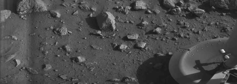
Transmission of the first surface image began 25 seconds after landing and took about four minutes (see below). During these minutes the lander activated itself. It erected a high-gain antenna pointed toward Earth for direct communication and deployed a meteorology boom mounted with sensors. In the next seven minutes the second picture of the 300° panoramic scene (displayed below) was taken.[19] On the day after the landing the first colour picture of the surface of Mars (displayed below) was taken. The seismometer failed to uncage, and a sampler arm locking pin was stuck and took five days to shake out. Otherwise, all experiments functioned normally.
The lander had two means of returning data to Earth: a relay link up to the orbiter and back, and by using a direct link to Earth. The orbiter could transmit to Earth (S-band) at 2,000 to 16,000 bit/s (depending on distance between Mars and Earth), and the lander could transmit to the orbiter at 16,000 bit/s.[20] The data capacity of the relay link was about 10 times higher than the direct link.[13]
First "clear" image ever transmitted from the surface of Mars – shows rocks near the Viking 1 Lander (20 July 1976). The haze on the left is possibly dust that had recently been kicked up by the landing rockets. Because of the "slow scan" facsimile nature of the cameras, the dust settled by mid-image.
The lander had two facsimile cameras; three analyses for metabolism, growth or photosynthesis; a gas chromatograph-mass spectrometer; an x-ray fluorescence spectrometer; pressure, temperature and wind velocity sensors; a three-axis seismometer; a magnet on a sampler observed by the cameras; and various engineering sensors.[13]
 Photo of the Viking 1 Mars lander taken by the Mars Reconnaissance Orbiter in 2006
The Viking 1 lander was named the Thomas Mutch Memorial Station in January 1981 in honour of Thomas A. Mutch, the leader of the Viking imaging team.[21] The lander operated for 2,245 sols (about 2,306 Earth days or 6 years) until November 11, 1982 (sol 2600), when a faulty command sent by ground control resulted in loss of contact. The command was intended to uplink new battery charging software to improve the lander's deteriorating battery capacity, but it inadvertently overwrote data used by the antenna pointing software. Attempts to contact the lander during the next four months, based on the presumed antenna position, were unsuccessful.[22] In 2006, the Viking 1 lander was imaged on the Martian surface by the Mars Reconnaissance Orbiter.[23]
|
|
|
|
|
Viking 1 carried a biology experiment whose purpose was to look for evidence of life. The Viking lander biological experiments weighed 15.5 kg (34 lbs) and consisted of three subsystems: the pyrolytic release experiment (PR), the labeled release experiment (LR), and the gas exchange experiment (GEX). In addition, independent of the biology experiments, Viking carried a gas chromatograph-mass spectrometer that could measure the composition and abundance of organic compounds in the Martian soil.[24] The results were surprising and interesting: the spectrometer gave a negative result; the PR gave a negative result, the GEX gave a negative result, and the LR gave a positive result.[25] Viking scientist Patricia Straat stated in 2009, "Our [LR] experiment was a definite positive response for life, but a lot of people have claimed that it was a false positive for a variety of reasons."[26] Most scientists now believe that the data were due to inorganic chemical reactions of the soil; however, this view may be changing after the recent discovery of near-surface ice near the Viking landing zone.[27] Some scientists still believe the results were due to living reactions. No organic chemicals were found in the soil. However, dry areas of Antarctica do not have detectable organic compounds either, but they have organisms living in the rocks.[28] Mars has almost no ozone layer, unlike the Earth, so UV light sterilizes the surface and produces highly reactive chemicals such as peroxides that would oxidize any organic chemicals.[29] The Phoenix Lander discovered the chemical perchlorate in the Martian soil. Perchlorate is a strong oxidant so it may have destroyed any organic matter on the surface.[30] If it is widespread on Mars, carbon-based life would be difficult at the soil surface.
First panorama by Viking 1 lander
[edit]
First panoramic view by Viking 1 from the surface of Mars. Captured on 20 July 1976.
Viking 1 image gallery
[edit]
-
Launch of the Viking 1 probe (20 August 1975)
-
Proof test article of the Viking Mars Lander
-
First image by the Viking 1 lander from the surface of Mars, showing lander's footpad
-
Viking 1 lander image of a Martian sunset over Chryse Planitia
-
Trenches dug by soil sampler device
-
First colour image taken by the Viking 1 lander (21 July 1976)
-
Viking 1 lander site (11 February 1978)
-
Dunes and large boulder. Pole in the centre is an instrument boom.
-
Viking 1 Lander Camera 2 Sky at sunrise (Low Resolution Colour) Sol 379 07:50
Test of general relativity
[edit]
 High-precision test of general relativity by the Cassini space probe (artist's impression) High-precision test of general relativity by the Cassini space probe (artist's impression)
Gravitational time dilation is a phenomenon predicted by the theory of general relativity whereby time passes more slowly in regions of lower gravitational potential. Scientists used the lander to test this hypothesis, by sending radio signals to the lander on Mars, and instructing the lander to send back signals, in cases which sometimes included the signal passing close to the Sun. Scientists found that the observed Shapiro delays of the signals matched the predictions of general relativity.[31]
|
|
|
|
|
by European Space Agency
 To mark 20 years of ESA’s Mars Express, the High Resolution Stereo Camera (HRSC) team has produced a new global colour mosaic: Mars as never seen before. The mosaic reveals the planet’s surface colour and composition in spectacular detail. Credit: ESA/DLR/FU Berlin/G. Michael 12 November 2024 marks the start of a new year on Mars. At exactly 10:32 CET/09:32 UTC on Earth, the Red Planet begins a new orbit around our sun.
This is the 38th Martian year. The convention for counting years in the Martian calendar started in 1955, with the first year coinciding with a major storm named "the great dust storm of 1956."
There are some significant differences between years on the two planets:
- Days: A Martian day is called a "sol" and lasts 24 hours and 39 minutes, slightly longer than an Earth day.
- Years: One year on Mars equals 687 Earth days, or 668 sols, nearly twice as long as an Earth year. If you would like to know your Martian age, divide your current age by 1.88 and tell your friends how much younger you are… on Mars, at least!
- New Year: The Martian New Year begins on the northern equinox (northern spring, southern autumn on Mars).
- Seasons: Like Earth, Mars has four seasons—winter, spring, summer and autumn. Unlike Earth's seasons, Martian seasons are not of equal lengths due to Mars' more elliptical orbit. The planet's axial tilt causes the northern hemisphere to receive more sunlight during the northern summer, and the southern hemisphere to receive more sunlight in northern winter. Winter and summer come when the northern and southern hemispheres tilt away from the sun in turn.
- Dust seasons: The second half of the Martian year is often marked by fierce dust storms that can sometimes become planet-wide. As Mars swings closer to the sun, the atmosphere heats up, causing winds to lift up very fine particles from the Martian soil. Once airborne, these brownish particles heat up and redistribute some of that warmth to the surrounding atmosphere. This process can rapidly pump a lot of dust.
- Weather: Temperature swings between day and night are extreme on Mars. At noon on a summer's day, air temperature can reach 0ºC but will plunge to -60ºC at night. In winter, night temperatures are even colder, dropping to -110ºC. A recurring weather phenomenon is the Arsia Mons Elongated Cloud, a cloud of ice crystals that can reach up to 1800 kilometers in length.
 Credit: European Space Agency
https://phys.org/news/2024-11-happy-year-mars.html
|
|
|
|
|
La sonda espacial con destino a Saturno pone a prueba la teoría de Einstein
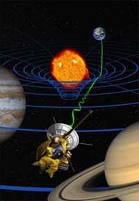 Concepto artístico del experimento de relatividad general. Concepto artístico del experimento de relatividad general.Un experimento realizado por científicos italianos con datos de la nave espacial Cassini de la NASA, actualmente en camino a Saturno, confirma la teoría de la relatividad general de Einstein con una precisión 50 veces mayor que las mediciones anteriores.
Los resultados aparecen en la edición del 25 de septiembre de la revista Nature. Forman parte de una colaboración científica entre la NASA y la Agencia Espacial Italiana. El experimento tuvo lugar en el verano de 2002, cuando la nave espacial y la Tierra se encontraban en lados opuestos del Sol, separados por una distancia de más de mil millones de kilómetros (aproximadamente 621 millones de millas).
Los investigadores observaron el cambio de frecuencia de las ondas de radio que se transmitían desde y hacia la nave espacial a medida que pasaban cerca del Sol. Midieron con precisión el cambio en el tiempo de ida y vuelta de la señal de radio a medida que viajaba cerca del Sol. El tiempo de ida y vuelta es el tiempo que tarda la señal transmitida desde la estación de la Red del Espacio Profundo en Goldstone, California, hasta la nave espacial en el otro lado del Sol y de regreso viajando a la velocidad de la luz.
"La importancia científica de estos resultados es la confirmación de la teoría de la relatividad general y la concordancia con las formulaciones de Einstein con una precisión experimental sin precedentes", dijo Sami Asmar, director del Radio Science Group, que adquirió los datos para este experimento en el Laboratorio de Propulsión a Chorro de la NASA en Pasadena, California. "La importancia tecnológica del experimento es la capacidad de superar el duro entorno solar mediante enlaces de radio".
Los investigadores midieron en qué medida la gravedad del Sol curvaba un rayo electromagnético, en este caso la señal de radio transmitida por la nave espacial y recibida por las estaciones terrestres.
Según la teoría de la relatividad general, un objeto masivo como el Sol hace que el espacio-tiempo se curve, y un haz de ondas de radio (o luz) que pasa por el Sol tiene que viajar más lejos debido a la curvatura. La distancia adicional que recorren las ondas de radio desde Cassini pasando por el Sol hasta la Tierra retrasa su llegada; la magnitud del retraso proporciona una prueba sensible de las predicciones de la teoría de Einstein. Aunque se esperan desviaciones de la relatividad general en algunos modelos cosmológicos, no se encontró ninguna en este experimento.
Las pruebas de la relatividad general tienen importantes implicaciones cosmológicas. La cuestión no es si la relatividad general es verdadera o falsa, sino a partir de qué nivel de precisión deja de describir la gravedad de forma realista.
Pruebas anteriores de la relatividad general confirmaron la predicción de Einstein con una precisión de una parte por mil. Esta precisión se logró en 1979 utilizando las sondas Viking en Marte. El experimento Cassini la confirmó con una precisión de 20 partes por millón. La clave de esta mejora ha sido la adopción de nuevas tecnologías en las telecomunicaciones espaciales.
El experimento no se hubiera podido realizar con este nivel de precisión en el pasado debido al ruido en el enlace de radio introducido por la corona solar. Con el experimento Cassini, este obstáculo se superó equipando el sistema de comunicación de la nave espacial con múltiples enlaces en diferentes frecuencias. Esta nueva capacidad en la nave espacial Cassini y en la antena de 34 metros (112 pies) de diámetro en Goldstone, permitió a los científicos eliminar los efectos del plasma interplanetario y solar de los datos de radio. Además, el ruido de la atmósfera de la Tierra se redujo considerablemente mediante un equipo especial instalado en el complejo Goldstone. Estos avances tecnológicos desarrollados para la misión Cassini han llevado a precisiones sin precedentes en las mediciones de velocidad, lo que beneficia a futuros experimentos científicos, así como a la navegación en el espacio profundo.
Los experimentos son parte de una serie de experimentos de radiociencia planificados para la fase de crucero de la misión, incluida la búsqueda de ondas gravitacionales de baja frecuencia.
Cassini comenzará a orbitar Saturno el 1 de julio de 2004 y liberará su sonda Huygens unos seis meses después para descender a través de la espesa atmósfera de la luna Titán.
Cassini-Huygens es una misión cooperativa de la NASA, la Agencia Espacial Europea y la Agencia Espacial Italiana. El JPL, una división de Caltech, administra la misión para la Oficina de Ciencias Espaciales de la NASA en Washington, DC. Los autores del artículo de Nature, "Una nueva prueba de la relatividad general con la misión espacial Cassini", son el Dr. Bruno Bertotti de la Universidad de Pavía, Italia; el Dr. Luciano Iess de la Universidad de Roma "La Sapienza", Italia; y el Dr. Paolo Tortora de la Universidad de Bolonia, Italia.
https://solarsystem-nasa-gov.translate.goog/news/12249/saturn-bound-spacecraft-tests-einsteins-theory/?_x_tr_sl=en&_x_tr_tl=es&_x_tr_hl=es&_x_tr_pto=sc |
|
|
|
|
ANCIENT EGYPTIAN GEODESY - PART II
The great circle alignment from Giza to Alexandria has an azimuth of 51.85° north of due west from Giza (the same angle as the slope of the Great Pyramid). Extended beyond Alexandria, this great circle also crosses over Delphi, Rollright and Newgrange, as well as the city of London.
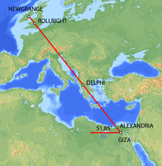
Map image © VectorGlobe
The azimuth of a great circle alignment from Dendera to Paris is also 51.85° north of due west.
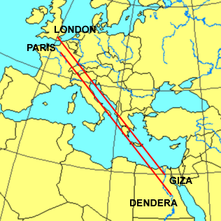
Map image - Roger Hedin
Dendera was dedicated to Isis/Sirius. The ancient Egyptian year began on the date of the heliacal rising of Sirius in mid July. The helical rising of Sirius heralded the annual inundation of the Nile that was essential to the welfare of ancient Egypt. The axis of the temple of Isis at Dendera was aligned 20° south of due east, pointing directly at the rising point of Sirius from the latitude of Dendera.
Robert Bauval describes a number of connections between Isis/Sirius and Paris in Talisman (2004). Isis is shown riding on a boat in many ancient Egyptian drawings and carvings. At the direction of Napoleon, Sirius and a statue of Isis were added to the coat of arms for Paris shown below.

During the French revolution, a statue of Isis known as the Fountain of Regeneration was constructed on the former site of the Bastille. The engraving below commemorated this statue.

Fountain of Regeneration Engraving
The Elysian Fields is described as a place of eternal salvation in the ancient Egyptian Book of the Dead. Named after the Elysian Fields, the Champs Elysees is the main axis of Paris. The names Elysian and Elysees both suggest an association with Isis. The photograph below is facing southeast. The Arc de Triumphe is visible in the background. Beyond the Arc de Triumphe is the Louvre. The azimuth of the Champs Elysees is 26° south of due east, pointing directly at the rising point of Sirius/Isis from the latitude of Paris.

The termination point of the Champs Elysees to the northwest is the Grande Arche, in the foreground of the picture above. The axis of the Grande Arche is offset 6.33° south of the axis of the Champs Elysees. With an azimuth of just over 32° south of due east, the azimuth of the axis of the Grande Arche is the same as the azimuth of the great circle alignment from Paris to Dendera.
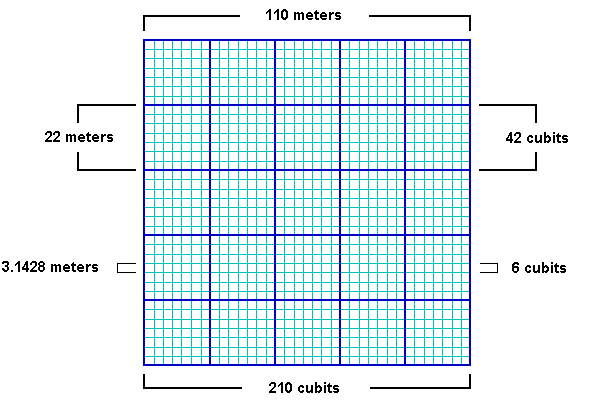
The Grande Arche is a nearly perfect cube with a height of 110 meters, a width of 108 meters and a depth of 112 meters. It is often described as a cube with side lengths of 110 meters. This is equal to 210 ancient Egyptian cubits:
110/210 = .5238
.5238 meters is a precise measure of the ancient Egyptian cubit, equating to 20.6222 inches, well within the ± .005 inches in Petrie's 20.62 inch measure of the ancient Egyptian cubit. Instead of the usual comparisons between the cubit and the meter of .52375/1 or .524/1, the best comparative measure may be the simple fraction of 11/21 that is suggested by the Grande Arche.

Image © Insecula.com
The sides of the Grande Arche are divided into 5 x 5 large panels and within each large panel are 7 x 7 smaller panels. Side lengths of 110 meters suggest lengths of 22 meters for the sides of the large panels with lengths of 22/7 meters for the sides of the smaller panels. The fraction 22/7 equals 3.1428, an accurate expression of π that is also found in the dimensions of the Great Pyramid. Side lengths of 210 cubits in the Grande Arche suggest lengths of 42 cubits for the sides of the large panels and 6 cubits for the sides of the smaller panels. This also shows that the relationship between the meter and the cubit is 6/π, using the measure of 22/7 for π:
21/11 = 6/π
22/7 x 21/11 = 6
The northern pyramid at Dashur, known as the Red Pyramid, was the first true (smooth sided) pyramid built in Egypt and it was the last pyramid built prior to construction of the Great Pyramid. The baselengths of the Red Pyramid are 420 cubits (220 meters) long, 20x multiples of 21/11.
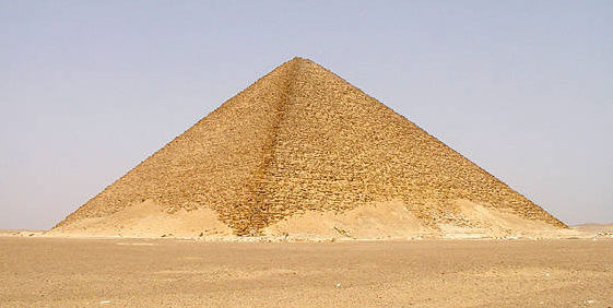
Image by Jon Bodsworth
One of the oldest stone circles in England is at Rollright. The diameter of the Rollright circle is 31.4 meters, an accurate expression of π times 10 meters. Given the 6/π relationship between the meter and the cubit, the diameter of the Rollright circle is also 60 ancient Egyptian cubits.

BACK
http://home.hiwaay.net/~jalison/Art5.html |
|
|
|
|
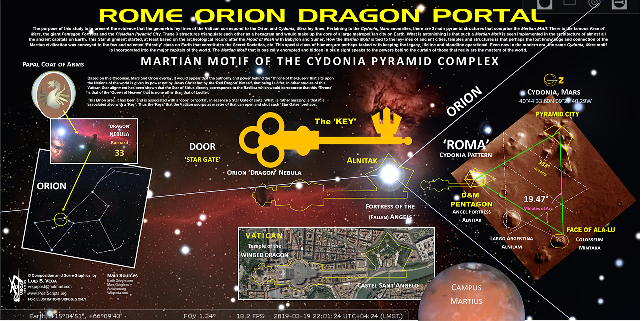
ANCIENT EGYPTIAN GEODESY - PART II
The great circle alignment from Giza to Alexandria has an azimuth of 51.85° north of due west from Giza (the same angle as the slope of the Great Pyramid). Extended beyond Alexandria, this great circle also crosses over Delphi, Rollright and Newgrange, as well as the city of London.

Map image © VectorGlobe
The azimuth of a great circle alignment from Dendera to Paris is also 51.85° north of due west.

Map image - Roger Hedin
Dendera was dedicated to Isis/Sirius. The ancient Egyptian year began on the date of the heliacal rising of Sirius in mid July. The helical rising of Sirius heralded the annual inundation of the Nile that was essential to the welfare of ancient Egypt. The axis of the temple of Isis at Dendera was aligned 20° south of due east, pointing directly at the rising point of Sirius from the latitude of Dendera.
Robert Bauval describes a number of connections between Isis/Sirius and Paris in Talisman (2004). Isis is shown riding on a boat in many ancient Egyptian drawings and carvings. At the direction of Napoleon, Sirius and a statue of Isis were added to the coat of arms for Paris shown below.

During the French revolution, a statue of Isis known as the Fountain of Regeneration was constructed on the former site of the Bastille. The engraving below commemorated this statue.

Fountain of Regeneration Engraving
The Elysian Fields is described as a place of eternal salvation in the ancient Egyptian Book of the Dead. Named after the Elysian Fields, the Champs Elysees is the main axis of Paris. The names Elysian and Elysees both suggest an association with Isis. The photograph below is facing southeast. The Arc de Triumphe is visible in the background. Beyond the Arc de Triumphe is the Louvre. The azimuth of the Champs Elysees is 26° south of due east, pointing directly at the rising point of Sirius/Isis from the latitude of Paris.

The termination point of the Champs Elysees to the northwest is the Grande Arche, in the foreground of the picture above. The axis of the Grande Arche is offset 6.33° south of the axis of the Champs Elysees. With an azimuth of just over 32° south of due east, the azimuth of the axis of the Grande Arche is the same as the azimuth of the great circle alignment from Paris to Dendera.
The Grande Arche is a nearly perfect cube with a height of 110 meters, a width of 108 meters and a depth of 112 meters. It is often described as a cube with side lengths of 110 meters. This is equal to 210 ancient Egyptian cubits:
110/210 = .5238
.5238 meters is a precise measure of the ancient Egyptian cubit, equating to 20.6222 inches, well within the ± .005 inches in Petrie's 20.62 inch measure of the ancient Egyptian cubit. Instead of the usual comparisons between the cubit and the meter of .52375/1 or .524/1, the best comparative measure may be the simple fraction of 11/21 that is suggested by the Grande Arche.

Image © Insecula.com
The sides of the Grande Arche are divided into 5 x 5 large panels and within each large panel are 7 x 7 smaller panels. Side lengths of 110 meters suggest lengths of 22 meters for the sides of the large panels with lengths of 22/7 meters for the sides of the smaller panels. The fraction 22/7 equals 3.1428, an accurate expression of π that is also found in the dimensions of the Great Pyramid. Side lengths of 210 cubits in the Grande Arche suggest lengths of 42 cubits for the sides of the large panels and 6 cubits for the sides of the smaller panels. This also shows that the relationship between the meter and the cubit is 6/π, using the measure of 22/7 for π:
21/11 = 6/π
22/7 x 21/11 = 6

The northern pyramid at Dashur, known as the Red Pyramid, was the first true (smooth sided) pyramid built in Egypt and it was the last pyramid built prior to construction of the Great Pyramid. The baselengths of the Red Pyramid are 420 cubits (220 meters) long, 20x multiples of 21/11.

Image by Jon Bodsworth
One of the oldest stone circles in England is at Rollright. The diameter of the Rollright circle is 31.4 meters, an accurate expression of π times 10 meters. Given the 6/π relationship between the meter and the cubit, the diameter of the Rollright circle is also 60 ancient Egyptian cubits.

BACK
http://home.hiwaay.net/~jalison/Art5.html |
|
|
 Primer Primer
 Anterior
14 a 28 de 28
Siguiente Anterior
14 a 28 de 28
Siguiente
 Último

|
|
| |
|
|
©2025 - Gabitos - Todos los derechos reservados | |
|
|











 To mark 20 years of ESA’s Mars Express, the High Resolution Stereo Camera (HRSC) team has produced a new global colour mosaic: Mars as never seen before. The mosaic reveals the planet’s surface colour and composition in spectacular detail. Credit: ESA/DLR/FU Berlin/G. Michael
 Credit: European Space Agency


