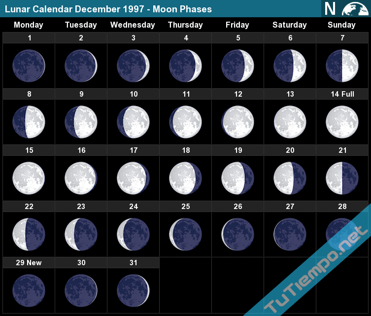
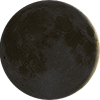
 The Moon phase on Wednesday, December 31, 1997 is Waxing Crescent with an illumination of 7.18%. This indicates the percentage of the Moon illuminated by the Sun. On Wednesday, December 31, 1997, the Moon is 2.55 days old. This number shows how many days have passed since the last New Moon.
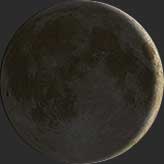

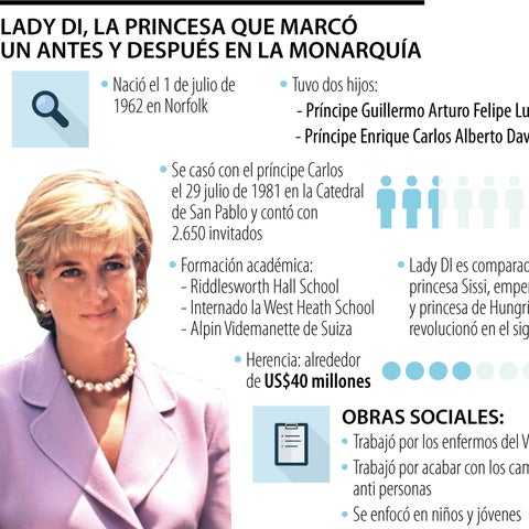
No todos los linajes son iguales. Si bien cabría esperar que el príncipe Carlos fuera el máximo exponente de la realeza, otros son incluso de mejor cuna. Por ejemplo, su difunta esposa. La familia de la princesa Diana, la Casa Spencer, es una dinastía británica de larga tradición que se remonta al siglo XVI. Los Windsor , en cambio, son de ascendencia alemana, y adoptaron su apellido actual en 1917. Es decir, Carlos ascendió socialmente por matrimonio.
Aquí, conozca a los Spencer.


1. Henry Spencer, primer conde de Sunderland (1620-1643)
El fundador de la casa Spencer nació como el tercer barón Spencer y más tarde recibió el título nobiliario del primer conde de Sunderland, lo que dio origen a un nuevo título para los hombres Spencer de mayor edad que duraría hasta la década de 1750.
2. Georgiana, duquesa de Devonshire (1757-1806)
La cuarta tía abuela de Diana también se casó con un hombre casi 10 años mayor que ella y fue vista como una influenciadora, popularizando el polvo francés para el cabello, entre otras tendencias.
3. Lady Diana Spencer (1710-1735)
Ella era la homónima de Diana, y mucho más. La Lady Di original estaba destinada a casarse con el príncipe de Gales, pero el primer ministro del rey Jorge II le advirtió que buscara una esposa que representara una amenaza política menor para su hijo.
4. Charles Spencer, tercer conde de Sunderland (1702-1722)
Fusionó a los Spencer con los Churchill a través de su matrimonio con Anne Churchill.
5. Sarah Churchill, duquesa de Marlborough (1660-1744)
Rachel Weisz la interpretó en The Favourite de 2018 , retratando su relación cercana (y posiblemente romántica) con la reina Ana.
6. Sir Winston Churchill (1874-1965)
El primer ministro era primo lejano de la princesa Diana. A día de hoy, algunos miembros de la familia aún llevan el apellido Spencer-Churchill.
7. Dama Bárbara Cartland (1901-2000)
La novelista romántica era la abuelastra de Diana (es decir, la madre de su madrastra). Ostenta el récord de más libros publicados en un solo año.
8. Albert Spencer, séptimo conde Spencer (1892-1975)
El abuelo de Diana fue miembro de la reserva del ejército. Su padrino fue el rey Eduardo VII.
9. Raine Spencer (1929-2016)
El segundo marido (de tres) de la socialité británica era el padre de Diana, aunque se dice que Diana y sus hermanos llamaban a su madrastra "Lluvia Ácida".
10. John Spencer, octavo conde Spencer (1924-1992)
El padre de Diana crió a la futura princesa y a sus tres hermanos, ya que le fue concedida la custodia tras su divorcio de Lady Frances Roche.
11. Lady Frances Roche (1936-2004)
La madre de Diana era una aristócrata por derecho propio, hija de un barón y una baronesa. En 1967, dejó a John Spencer por el heredero del papel pintado, Peter Shand Kydd.
12. Príncipe Carlos (1948- )
El Príncipe de Gales es, por supuesto, el heredero del trono británico y se casó con Diana cuando ella tenía 20 años. La pareja finalmente se divorció en 1996.
13. Princesa Diana (1961-1997)
La protagonista de nuestro árbol genealógico, la Princesa de Gales (nacida Diana Frances Spencer), fue una activista e icono de estilo.
14. Lady Sarah McCorquodale (1955-)
La hermana mayor de Diana salió con Carlos antes que Diana. De hecho, fue Sarah quien los presentó.
15. Lady Jane Fellowes (1957-)
La otra hermana de Diana se casó con Robert Fellowes. Posteriormente, este recibió el título nobiliario, lo que convirtió a Jane en baronesa.
16. Charles Spencer, noveno conde Spencer (1964-)
El hermano de Diana es escritor y reportero de televisión; reside en Althorp, la finca familiar. Es padre de siete hijos, entre ellos Lady Kitty Spencer.
17. Príncipe Guillermo (1982-)
Segundo en la sucesión al trono, el duque de Cambridge es el hijo mayor de Diana. Tiene tres hijos con su esposa, Catalina (de soltera Middleton).
18. Príncipe Harry (1984-)
El hijo menor de Diana, el duque de Sussex, se retiró de sus deberes reales en 2020. Ahora reina en Santa Bárbara, California, donde vive con su esposa Meghan (de soltera Markle) y sus dos hijos.
19. Lady Kitty Spencer (1990-)
La sobrina de Diana, de 30 años, se ha hecho famosa como modelo. Recientemente se casó con el magnate de la moda Michael Lewis, de 62 años.
20. George Washington (1732-1799)
El Padre Fundador era primo octavo de Diana, cinco veces eliminado.
21. Audrey Hepburn (1929-1993)
Audrey y Diana compartían algo más que un estilo: eran primas lejanas. Hepburn también pertenecía a la nobleza holandesa por parte de madre.
22. Glenn Close (1947-)
En el programa " Encontrando tus Raíces" de PBS , Close descubrió que era prima octava de Diana. Se conocieron en 1989, aunque desconocían su vínculo en ese momento.
23. Oliver Platt (1960-)
El actor era primo segundo de la Princesa de Gales a través de sus tatarabuelos, aunque ambos nunca se conocieron.
Una versión de esta historia apareció en la edición de noviembre de 2021 de Town & Country .