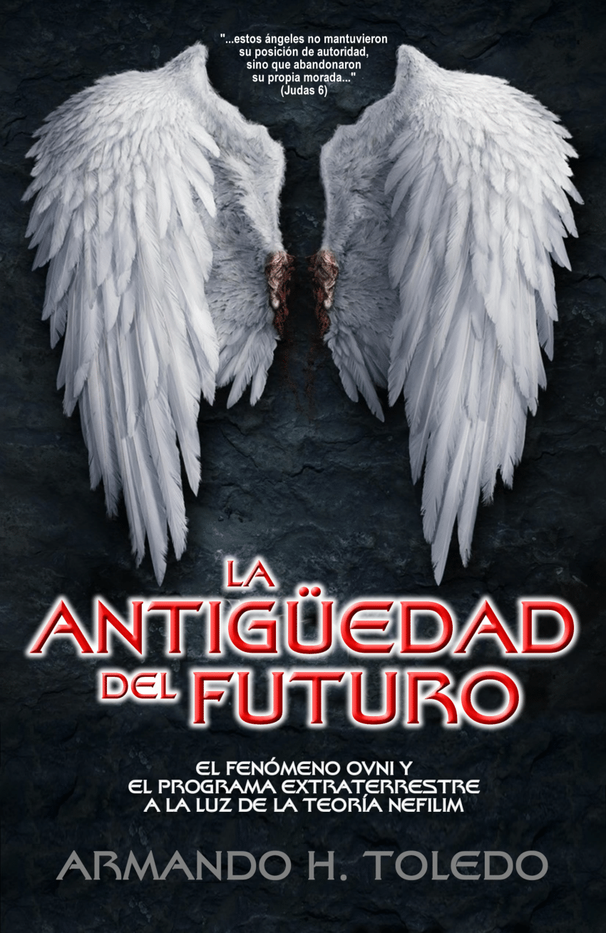
. Juan 16:21 La mujer cuando da a luz, tiene dolor, porque ha llegado su HORA; pero después que ha dado a luz un niño, ya no se acuerda de la angustia, por el gozo de que haya nacido un hombre en el mundo.
German Village is a historic neighborhood in Columbus, Ohio, just south of the city's downtown. It was settled in the early-to-mid-19th century by a large number of German immigrants, who at one time comprised as much as a third of the city's entire population. It became a city historic district in 1960[2] and was added to the National Register of Historic Places in 1974, becoming the list's largest privately funded preservation district,[3] and in 2007, was made a Preserve America Community by the federal government. In 1980, its boundaries increased, and today it is one of the world's premier historic restorations.
In 1796, Congress appropriated the Refugee Lands for Canadian province individuals who had supported the Colonial cause in the American Revolution. By 1802, an American Revolution veteran named John McGowan claimed 328 acres (1.33 km2), most of what would become the German Village. As German immigrants arrived, McGowan sold tracts of land to them. By 1814, a settlement had grown up, originally called "Das Alte Südende" (the Old South End), and German immigrants contributed to building the first statehouse.
By 1830, massive German immigration to the city had occurred. The most influential German newspaper in 1843 was Der Westbote. Many would serve in the American Civil War, thus gaining the universal respect of the local citizens. By 1865, one-third of Columbus's population was German and the community was flourishing. They built up the local neighborhood, including many businesses, such as Hessenauer Jewelers and Lazarus Department Stores, schools, and churches, such as the Ohio-historic St. Mary's Catholic Church, built in 1865 and adorned with a 197-foot (60 m) steeple in 1893.[4] German-American George J. Karb became mayor of the city, twice, at the end of the 19th century and again in the early 20th century.[5]
During the early 20th century, the south end saw newcomers from eastern Europe aside from German immigrants, resulting in brother neighborhoods such as the Hungarian Village.[6]
The local schools the German immigrants constructed and managed were so superior that English-speaking residents of Columbus chose to attend them, such as one that once stood at Fulton Street east of S. Fourth Street.[5][7]
Capt. Eddie Rickenbacker, a World War I hero from the Columbus German-American community
The area was in serious decline throughout the first half of the 20th century, partly due to anti-German sentiment during World War I. During that time, the teaching of German in public schools was banned and German textbooks were burned. German street names were changed, such as Germania Street becoming the present-day Stewart Avenue,[8] and Schiller Park was temporarily renamed Washington Park. The anti-German sentiment fueled by the media was so bad that in 1918, German books were burned on Broad Street and at the foot of the Schiller statue. German canine breeds were taken from their owners and slaughtered, including German Shepherds and Dachshunds. Despite the hatred, the Columbus German American community would produce one of America's finest heroes from the war, Captain Eddie Rickenbacker, for whom Rickenbacker International Airport in southern Columbus is named.
Further decline occurred later due to the closing of the local breweries during Prohibition. After the war, the south end was zoned for manufacturing, leading to the erosion of the area's residential feel. In World War II, the streetcar tracks and wrought-iron fences were confiscated for the war effort. By the 1950s, the area had become a slum and the city decided to demolish one-third of the neighborhood.[9][10]
With the Village nearing complete destruction, Frank Fetch defied the common wisdom and purchased a house on S. Wall Street, determined to rebuild the neighborhood. Fetch would create the German Village Society. In June 1960, the society hosted the first Haus und Garten Tour, which attracted visitors and the local media to eight restored homes and two gardens. Today, the tour is one of the city's most popular events.[11] Frank Fetch Park was named after him.
Concerned citizens managed to save its historic architecture from demolition in the 1960s by lobbying for a local commission, the German Village Commission, to have power over external changes made to buildings and by getting the area listed on the National Register of Historic Places in 1975.[11] As of 2009, the German Village Society has over 1,000 preservationists who maintain the historic quality of the buildings and neighborhood, and German Village is considered one of the most desirable areas to live in the city.[12] More than 1,600 buildings have been restored since 1960 and it is credited as one of the world's premiere restoration districts.[13] By the 1980s, the restoration was nearly complete. Today, it is the largest privately funded historic district on the National Register of Historic Places.[3]
German tradition has long reigned in the community in the form of an annual Oktoberfest festival. It originally took place in Schiller Park and has been held at various locations within the German Village neighborhood. Due to new development in the area, it now takes place at the Ohio State Fairgrounds / Ohio Expo Center. The festival was voted to be canceled in 2009, but the Schmidt (owners and operators of Schmidt's Sausage Haus) and Cox families stepped in to keep it running.[17] A smaller Oktoberfest still goes on in the German Village itself, at the Germania Gesang und Sport Verein (Singing and Sports Club) at 543 South Front Street in the old Schlee Brewmaster's House and outdoor garden.[18]
Although German Village is an eclectic community, the area is known as a residential gay village. While there are no gay establishments within German Village, the neighboring Brewery District and Merion Village have several.
Much of the area in present-day south downtown along I-70 was at one point considered part of German Village, including the Market Exchange District, which has experienced a revival alongside German Village.[19]
German Village is bound by Pearl Street on the west; East Livingston Avenue on the north; Lathrop Street, Brust Street, Grant Avenue, Jaeger Street, and Blackberry Alley on the east; and Nursery Lane on the south. [20]
Schiller Park, named after Johann Christoph Friedrich von Schiller (1759-1805), was once a community meeting ground for German immigrants. It is now the site of recreational facilities, gardens, and an amphitheater that hosts free live performances of Shakespearean plays during the summer months courtesy of Actors' Theatre of Columbus.[21] It is bounded by Jaeger Street and City Park, Reinhard, and Deshler Avenues. It has been the area's center for festivals and neighborhood activities since the 1800s.
The 23-acre park's main entrance, along City Park Avenue, greets visitors with the Huntington Gardens, sponsored by Huntington National Bank and maintained by volunteers, and the Schiller statue. The statue was presented to the park by local residents in 1891. It is a second casting of the statue in Munich, Germany, designed and executed by Max von Widnmann and unveiled on May 9, 1863. The Columbus statue was transported free of charge across the Atlantic. The park is also home to Umbrella Girl, dedicated to the citizens of German Village in October 1996 to replace the missing original sculpture.
The neighborhood's Stewart Alternative Elementary School, was built in 1874. It is one of the oldest remaining school buildings in Columbus, built at the same time as the First and Second Avenue Schools, also still extant.[22]
The Jordan River, in the state of Utah, United States, is a river about 51 miles (82 km) long. Regulated by pumps at its headwaters at Utah Lake, it flows northward through the Salt Lake Valley and empties into the Great Salt Lake. Four of Utah's six largest cities border the river: Salt Lake City, West Valley City, West Jordan, and Sandy. More than a million people live in the Jordan Subbasin, part of the Jordan River watershed that lies within Salt Lake and Utah counties. During the Pleistocene, the area was part of Lake Bonneville.
Members of the Desert Archaic Culture were the earliest known inhabitants of the region; an archaeological site found along the river dates back 3,000 years. Mormon pioneers led by Brigham Young were the first European American settlers, arriving in July 1847 and establishing farms and settlements along the river and its tributaries. The growing population, needing water for drinking, irrigation, and industrial use in an arid climate, dug ditches and canals, built dams, and installed pumps to create a highly regulated river.
Although the Jordan was originally a cold-water fishery with 13 native species, including Bonneville cutthroat trout, it has become a warm-water fishery where the common carp is most abundant. It was heavily polluted for many years by raw sewage, agricultural runoff, and mining wastes. In the 1960s, sewage treatment removed many pollutants. In the 21st century, pollution is further limited by the Clean Water Act, and, in some cases, the Superfund program. Once the home of bighorn sheep and beaver, the contemporary river is frequented by raccoons, red foxes, and domestic pets. It is an important avian resource, as are the Great Salt Lake and Utah Lake, visited by more than 200 bird species.
The Jordan River is Utah Lake's only outflow. It originates at the northern end of the lake between the cities of Lehi and Saratoga Springs. It then meanders north through the north end of Utah Valley for approximately 8 miles (13 km) until it passes through a gorge in the Traverse Mountains, known as the Jordan Narrows. The Utah National Guard base at Camp Williams lies on the western side of the river through much of the Jordan Narrows.[7][8] The Turner Dam, located 41.8 miles (67.3 km) from the river's mouth (or at river mile 41.8) and within the boundaries of the Jordan Narrows, is the first of two dams of the Jordan River. Turner Dam diverts the water to the right or easterly into the East Jordan Canal and to the left or westerly toward the Utah and Salt Lake Canal. Two pumping stations situated next to Turner Dam divert water to the west into the Provo Reservoir Canal, Utah Lake Distribution Canal, and Jacob-Welby Canal. The Provo Reservoir Canal runs north through Salt Lake County, Jacob-Welby runs south through Utah County. The Utah Lake Distribution Canal runs both north and south, eventually leading back into Utah Lake.[9] Outside the narrows, the river reaches the second dam, known as Joint Dam, which is 39.9 miles (64.2 km) from the river's mouth. Joint Dam diverts water to the east for the Jordan and Salt Lake City Canal and to the west for the South Jordan Canal.[10][11][12]
Map of the Salt Lake Valley
The river then flows through the middle of the Salt Lake Valley, initially moving through the city of Bluffdale and then forming the border between the cities of Riverton and Draper.[7] The river then enters the city of South Jordan where it merges with Midas Creek from the west. Upon leaving South Jordan, the river forms the border between the cities of West Jordan on the west and Sandy and Midvale on the east. From the west, Bingham Creek enters West Jordan. Dry Creek, an eastern tributary, combines with the main river in Sandy. The river then forms the border between the cities of Taylorsville and West Valley City on the west and Murray and South Salt Lake on the east. The river flows underneath Interstate 215 in Murray. Little and Big Cottonwood Creeks enter from the east in Murray, 21.7 miles (34.9 km) and 20.6 miles (33.2 km) from the mouth respectively. Mill Creek enters on the east in South Salt Lake, 17.3 miles (27.8 km) from the mouth. The river runs through the middle of Salt Lake City, where the river travels underneath Interstate 80 a mile west of downtown Salt Lake City and again underneath Interstate 215 in the northern portion of Salt Lake City. Interstate 15 parallels the river's eastern flank throughout Salt Lake County. At 16 miles (26 km) from the mouth, the river enters the Surplus Canal channel. The Jordan River physically diverts from the Surplus Canal through four gates and heads north with the Surplus Canal heading northwest. Parley's, Emigration, and Red Butte Creeks converge from the east through an underground pipe, 14.2 miles (22.9 km) from the mouth.[7] City Creek also enters via an underground pipe, 11.5 miles (18.5 km) from the river's mouth. The length of the river and the elevation of its mouth varies year to year depending on the fluctuations of the Great Salt Lake caused by weather conditions. The lake has an average elevation of 4,200 feet (1,300 m) which can deviate by 10 feet (3.0 m).[3] The Jordan River then continues for 9 to 12 miles (14 to 19 km) with Salt Lake County on the west and North Salt Lake and Davis County on the east until it empties into the Great Salt Lake.[7][8][11]
The United States Geological Survey maintains a stream gauge in Salt Lake City that shows annual runoff from the period 1980–2003 is just over 150,000 acre-feet (190,000,000 m3) per year or 100 percent of the total 800,000 acre-feet (990,000,000 m3) of water entering the Jordan River from all sources. The Surplus Canal carries almost 60 percent of the water into the Great Salt Lake, with various irrigation canals responsible for the rest. The amount of water entering the Jordan River from Utah Lake is just over 400,000 acre-feet (490,000,000 m3) per year. Inflow from the 11 largest streams feeding the Jordan River, sewage treatment plants, and groundwater each account for approximately 15 percent of water entering the river.[13]
LA HERIDA SERA SANADA DEL VATICANO COMO LA EDAD MEDIA .
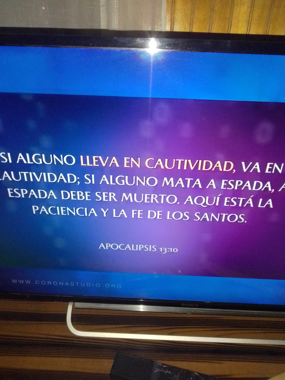
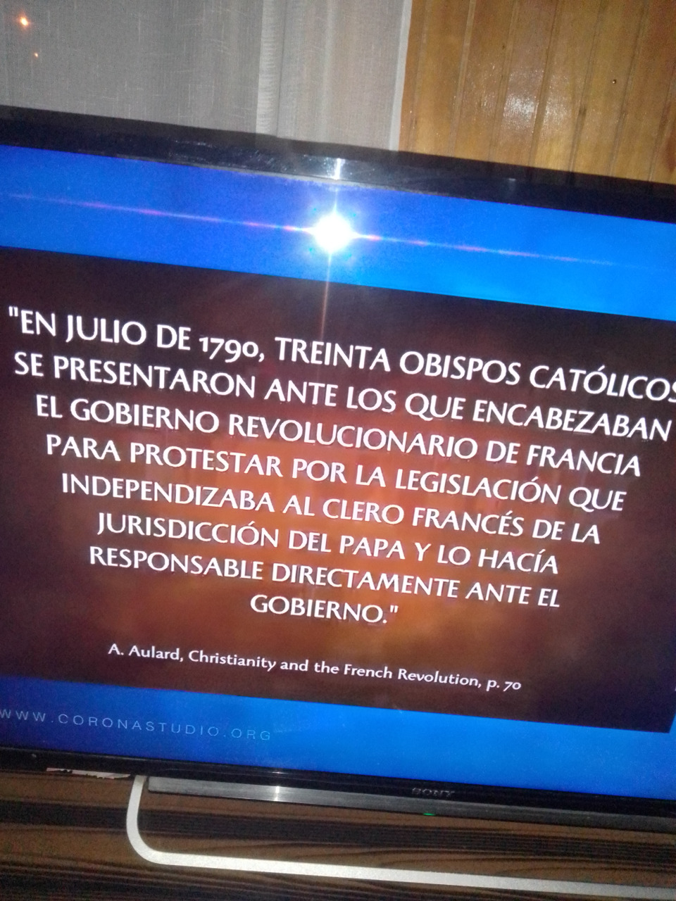
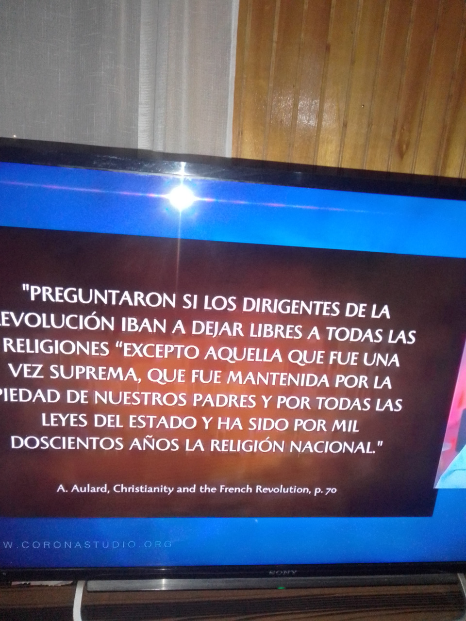
Apocalipsis (de Juan) 13-> Ver. 3Una de sus cabezas parecía herida de muerte, pero su llaga mortal se le curó; entonces la tierra entera siguió maravillada a la Bestia.
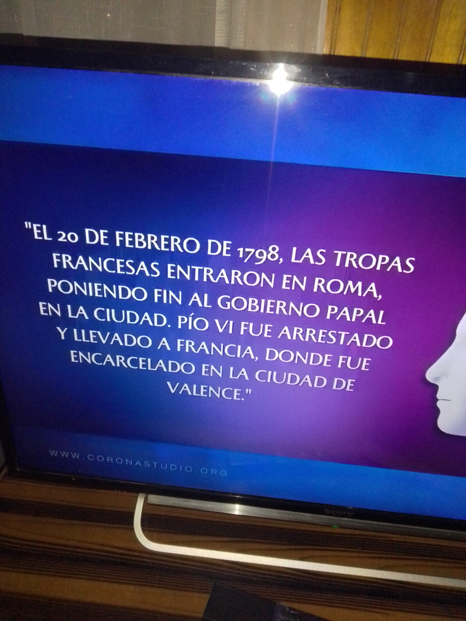
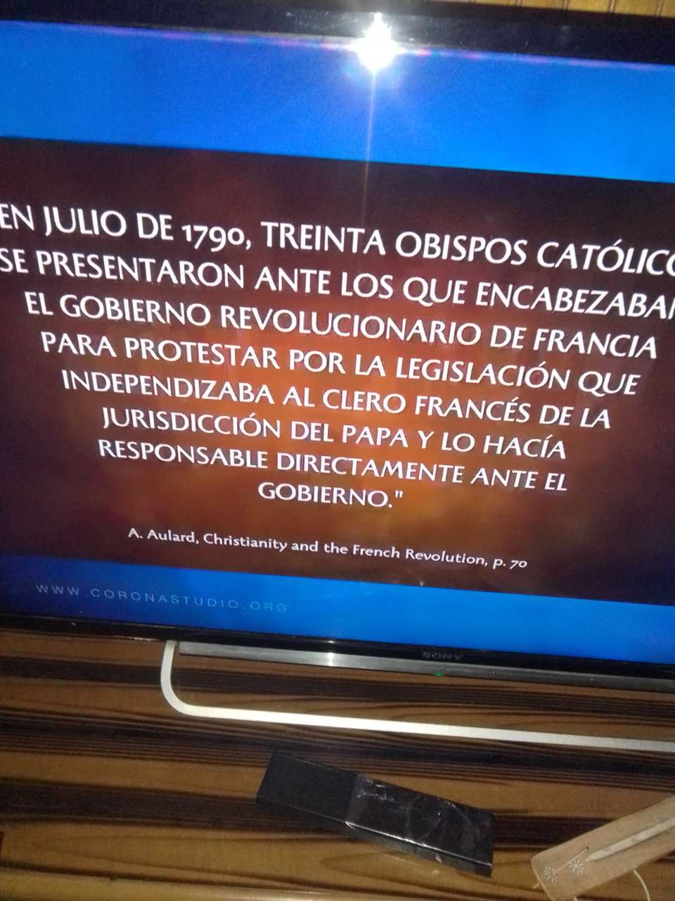
[V.3-> Una de sus cabezas. Ver com. Ap 13:1. Herida. Gr. sfázō, “matar”, “degollar”. Es afín de la palabra que se traduce “inmolado” en el Ap 5:6. Los adventistas creen que esta predicción se cumplió asombrosamente en 1798, cuando el general Berthier entró en Roma a la cabeza del ejército francés y declaró que había terminado el poder político del papa. Tomó prisionero al papa, lo llevó a Francia, donde poco después murió (ver com. Dan 7:25; CS 492). Sin embargo, este suceso sólo marcó la culminación de una larga serie de acontecimientos. La decadencia del poder papal había comenzado muchos años antes (ver Nota Adicional de Dan. 7). El comienzo de la Reforma protestante fue un hecho significativo en la larga serie de acontecimientos. Su herida. Gr. pl’g’, “un golpe”, también la herida producida por un golpe. Uno u otro significado puede adaptarse en este versículo. La “herida de muerte” podría ser, o el golpe que produce la muerte, o la herida que produce la muerte. Fue sanada. En los años que transcurrieron después de la Revolución Francesa se produjo un reavivamiento gradual del sistema papal. El papa sufrió un nuevo golpe en 1870, cuando le fueron quitados los Estados papales. Un suceso importante aconteció en 1929 cuando, por el tratado de Letrán, el poder temporal le fue restaurado al papa. Recibió entonces el gobierno de la Ciudad del Vaticano, una sección de la ciudad de Roma, que ocupa una extensión de unas 44 hectáreas. Sin embargo, el profeta contempla que hay una restauración mucho mayor. Vio la herida completamente curada, como lo insinúa el texto griego. Juan vio, además, que después de la curación “todos los moradores de la tierra” -excepto unos pocos fieles- adoraron a la bestia (Ap 13:8; cf. CS 636). Esta adoración aún se halla en el futuro. Aunque el papado recibe el homenaje de ciertos sectores, enormes conjuntos humanos no le rinden pleitesía. Pero esto cambiará. La bestia del Ap 13:11 “hace que la tierra y los moradores de ella adoren a la primera bestia, cuya herida mortal fue sanada” (Ap 13:12). Se maravilló toda la tierra. Parecía increíble que pudiera resurgir el poder papal; pero la profecía ha declarado que así sucedería. ]
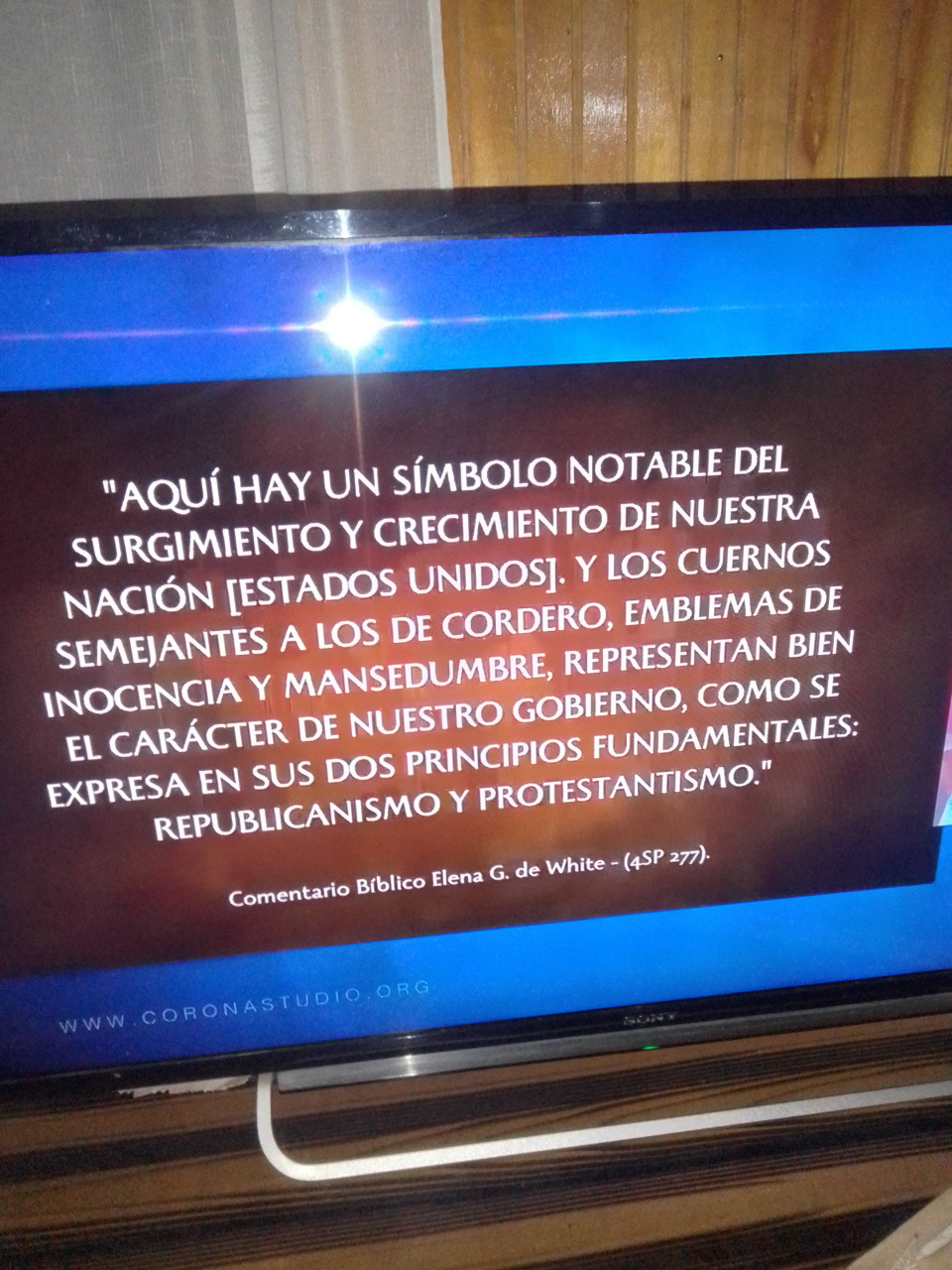
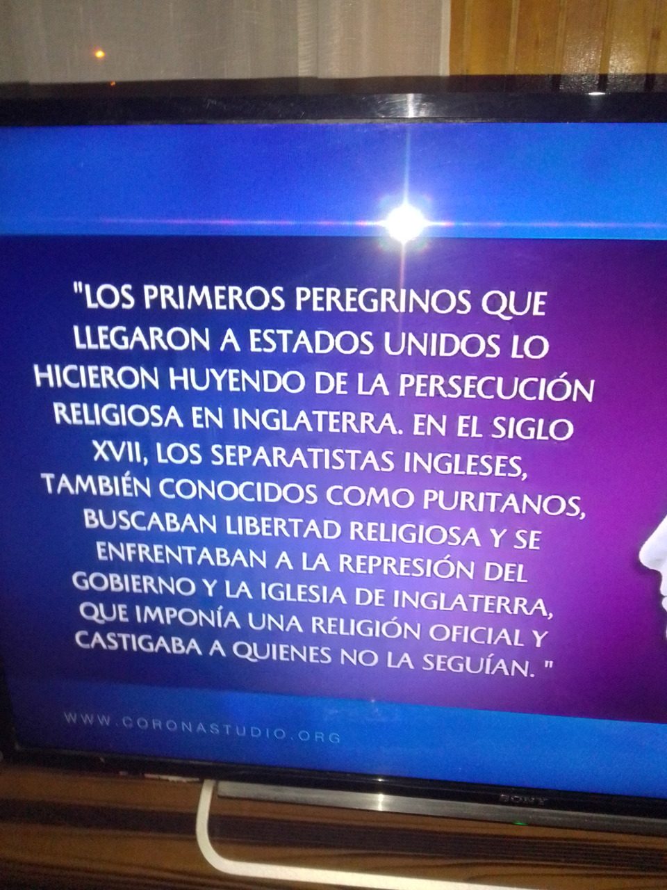
Los catolicos reconocen el cambio de santo sabado instituido por cristo en la creacion y el de Cristo obedecio mientras vivio en este mundo y dejo claro en el Apocalipsis como el dia de su creacion adorar al creador Apocalipsis 14:7,14:12 de su ley del cielo sinai y su sello escrito con su dedo Exodo 20:1,17,31:12,18,Apocalipsis7:2,3.Comparelo con apoc15:2 mas la marca de la bestia La ONU EEUU Vaticano Laudato si cambio climático con la marca de la bestia catecismo domingo misa .Apocal 13:2 16:13,14 13 Y vi que de la boca del Dragón, de la boca de la Bestia y de la boca del falso profeta, salían tres espíritus inmundos como ranas. Apocalipsis (de Juan) 16-> Ver. [V.13-> Vi. Ver com. Ap 1:1. De la boca. La boca es el instrumento del habla. Estos “tres espíritus inmundos” que salen de las bocas del “dragón”, de la “bestia” y del “falso profeta”, representan la política que esta triple unión religiosa proclamará al mundo, la cual se menciona en el Ap 17:2 como el “vino” de Babilonia (ver com. Ap 16:14; Ap 17:2; Ap 17:6). Dragón. Ver com. Ap 12:3; Ap 13:1. El primer miembro de esta triple unión religiosa se identifica generalmente con el espiritismo o con el paganismo. Este último consiste principalmente en la adoración de espíritus maléficos, y por eso se parece esencialmente al espiritismo moderno tal como se practica en los países cristianos. La bestia. Ver com. Ap 13:1; Ap 17:3; Ap 17:8. Falso profeta. Evidentemente debe identificarse con la segunda bestia del Ap 13:11-17 (ver com. Ap 16:11), que apoya a la primera bestia de los Ap 16:1-10, y que por medio de los milagros que tiene el poder de hacer en presencia de la bestia (Ap 16:12-14), engaña a los hombres para que le hagan a ésta una “imagen”. Cf. Ap 19:20; Ap 20:10. Tres espíritus inmundos. Los defensores de ambas opiniones concuerdan en identificar al “dragón”, la “bestia” y el “falso profeta”, con el espiritismo moderno (CS 645) o paganismo, el papado, y el protestantismo apóstata (cf. Ap 13:4; Ap 13:14-15; Ap 19:20; Ap 20:10), respectivamente. Los “tres espíritus inmundos” evidentemente simbolizan o representan a este trío maléfico de poderes religiosos, que juntos constituyen la “gran Babilonia” de los últimos días (Ap 16:13-14; Ap 16:18-19; ver com. Ap 16:19; Ap 17:5). A manera de ranas. Tal vez no deba atribuirse ningún significado a esta comparación, que quizá sólo tiene el propósito de destacar lo repulsivo que son los “tres espíritus inmundos” delante de Dios..YA VIENE LA MARCA DE LA BESTIA Apoc cap12:9,Cap13cap16cap17:8,13cap19:20,21cap9:20,21 .
El relicario, que fue realizado aproximadamente entre 1190 y 1225 por el orfebre Nicolás de Verdún, es considerado el relicario más grande y artísticamente exigente que se ha conservado de la Edad Media. Está construido en dos niveles en forma de basílica y decorado con figuras doradas, joyas de piedras preciosas, gemas, camafeos y esmaltes, que ilustran la historia de la salvación cristiana desde los comienzos del Antiguo Testamento hasta el Juicio Final. Se le considera el punto culminante del arte mosano y el relicario más grande en el mundo occidental.
Moneda de plata de Colonia de 1516 que representa a los Reyes Magos.
Durante la Segunda cruzada, el obispo de Milán San Eustorgio, religioso noble de origen helénico, visitó Constantinopla para que el Emperador le permitiera aceptar su reciente nombramiento; este no sólo le dio su consentimiento, sino que además le hizo un regalo inolvidable: las veneradas reliquias rescatadas en el año 300 d. C. por la emperatriz Elena, madre del emperador romano Constantino I, en Saba.
En los días de Felipe de Heinsberg fue construido el relicario de los tres magos. Esto me fue confirmado por algunos testigos oculares que estaban presentes cuando los tres magos fueron puestos en el relicario.
Partes del relicario fueron diseñadas por el famoso orfebre medieval, Nicolás de Verdún, que empezó el trabajo en el año 1180 o 1181. Tiene esculturas de oro elaboradas de los profetas y apóstoles, y de las escenas de la vida de Cristo. El relicario se completó hacia 1225.
Alrededor de 1199, el emperador Otón IV entregó tres coronas áureas para los reyes magos como un donación a la iglesia de Colonia: «Otto rex coloniensis curiam celebrans tres coronas de auro capitibus trium magorum imposuit»; MGSS 17, 292. A causa de la importancia del relicario y la catedral para el posterior desarrollo de la ciudad, el escudo de armas de Colonia muestra todavía las tres coronas que simbolizan a los Tres Reyes.
La construcción de la actual catedral de Colonia se empezó en 1248 para albergar estas importantes reliquias. La construcción de la catedral tomó 632 años, para llegar a ser actualmente la iglesiagótica más grande de Europa septentrional.
El 20 de julio de 1864, el relicario se abrió, y fueron descubiertos restos de los Tres Reyes y monedas de Philipp von Heinsberg. El informe de un testigo ocular cuenta:
En un compartimiento especial del relicario que ahora se ve —junto con lo que queda de antiguas, viejas y podridas vendas, probablemente de biso, y con restos de resinas aromáticas y sustancias semejantes— numerosos huesos de tres personas, que bajo la guía de varios expertos presentes se podrían reunir en cuerpos casi completos: uno en su juventud temprana, el segundo en su virilidad temprana, el tercero más bien envejecido. Dos monedas, bracteates argentinos acuñados sólo por una cara, acompañaban lo anterior; uno, probablemente de los días de Philipp von Heinsberg, mostraba una iglesia, el otro mostraba una cruz, acompañado de la espada de mando a un lado, y del báculo obispal al otro.2
Nota: «Así como la moneda de Philipp en Hartzheim, coloniensis de nummariae de rei de historia, tabla 3 n.os 14, 16 (1754),3 pero sin inscripción; la otra (moneda) en forma cuadrada, con en el centro una cruz, acompañada de la espada de mando a un lado, y del báculo obispal al otro, también sin inscripción, ciertamente no es más reciente y podría ser quizá una moneda de Reinaldo [de Dassel]».4
Los huesos se envolvieron en seda blanca y fueron devueltos al relicario.
El relicario de los Reyes Magos tiene unas dimensiones aproximadas de 110 cm de ancho, 153 cm de alto, y 220 cm de largo. Los tres sarcófagos están superpuestos, tomando la forma de una especie de basílica: dos sarcófagos descansan pegados el uno al otro, y el tercer sarcófago descansa sobre las aristas superiores de los otros dos. Los laterales están completamente cubiertos, así que no hay espacio visible entre los sarcófagos. La estructura básica está hecha de madera, recubierta de oro y plata y decorada con filigranas, esmalte, y unas mil piedras preciosas. Estas últimas incluyen muchos camafeos y piezas grabadas, alguna aún precristiana.
Todo el relicario está envuelto con una elaborada cubierta decorativa. Hay 74 figuras en bajorrelieve de plata dorada en total, sin contar las figuras adicionales, más pequeñas, en la decoración del fondo. En los lados, las imágenes de profetas decoran la parte más baja, mientras que las imágenes de los apóstoles y evangelistas decoran la parte superior. Un extremo muestra (a través del fondo, de izquierda a derecha) imágenes de la Adoración de los Magos, María entronizada con el niño Jesús, y el Bautismo de Cristo, y arriba, Cristo entronizado en el Juicio Final. El otro extremo muestra las escenas de la Pasión: El Martirio de Cristo (abajo izquierda) y la Crucifixión (abajo izquierda), con Cristo resucitado arriba. Este extremo tiene asimismo un busto de Reinaldo de Dassel en el centro.
En la novela Baudolino (2000), Umberto Eco describe el descubrimiento y el donativo subsiguiente de las reliquias de Magos como un bulo del siglo xii perpetrado por el protagonista de la novela.
En la novela Mapa de huesos (2005), de James Rollins, el relicario contiene oro en estado monoatómico, producido por los Reyes Magos, en lugar de las santas reliquias.
En la novela Mercado de espejismos (2007) de Felipe Benítez Reyes, se describe irónicamente las aventuras de un grupo de traficantes de reliquias a las que se les dio como encargo el robo del relicario. La novel
"[T]his makes it rather clear that Janet Jackson, via exposing her right breast and her juxtaposition with Beyonce (representing the American spirit), was 'designed' to embody Lady Justice/Liberty - signifying or prompting the rebirth of the spirit of 'Columbia'. The prevalent 'blackness' additionally alludes to the pertinence of another related figure Mary Magdalene, recently made popular by the huge success of the book The Da Vinci Code, as this biblical/esoteric 'wife' of Jesus - embodying the feminine and sexuality - was sometimes portrayed as the 'Black Madonna'."
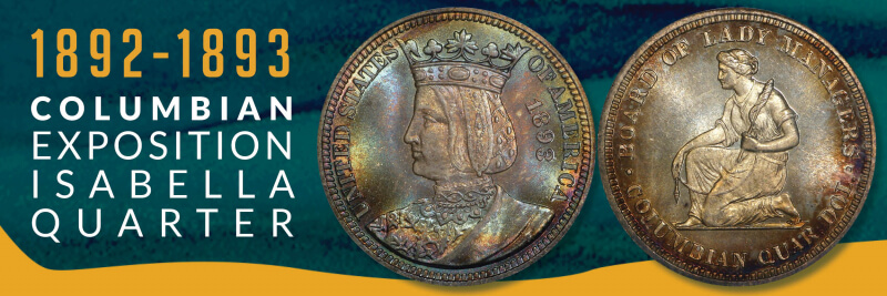
1893 Queen Isabella Commemorative Quarter. (Image via me)
A few things I’ve picked up from researching early commemorative coins:
The people behind them always hope they can raise a ton of money for a pet project or monument or expo. They rarely do.
The designs usually get denigrated by the numismatic press – oftentimes with a venom critics reserve for Limp Bizkit albums or Michael Bay movies.
The mint melts down the excess/unsold coins. As a result, the ones that did sell end up becoming valuable decades later – screwing over collectors on a budget like yours truly.
Those issues were all in play for the 1893 Isabella Quarter.
The Queen Isabella commemorative quarter traces its beginnings to the World’s Fair: Columbian Exposition, held in Chicago in 1893. Congress had already authorized the minting of a commemorative half dollar featuring Christopher Columbus, but a group of women, led by Bertha Palmer, whose husband, Potter, owned the famed Palmer House hotel in Chicago, thought they could do better.
Spearheaded by renowned women’s rights activist, and future $1 coin subject, Susan B. Anthony, the Board of Lady Managers had been awarded $10,000 in federal funds to help manage the Columbian Expo. In early 1893, the Board went before the House Appropriations Committee to ask that the $10,000 could be paid to them in the form of 40,000 specially designed commemorative quarters, which they could then sell at a profit. Congress obliged and the Board set about becoming “the authors of the first really beautiful and artistic coin that has ever been issued by the government of the United States.”
Obviously, the Board wanted a female on the obverse and decided on Queen Isabella I of Castile, who had provided vital financial support for Columbus’s voyages. Putting a foreign monarch on U.S. currency was unprecedented (indeed, there had a been a revolution over it), but according to Coin Week, the main source of conflict was over design.
Caroline Peddle, a former student of famed artist and coin designer Augustus Saint-Gaudens, was hired by the Board to design the coin. However, her sketches, which included a seated Isabella on the obverse and the inscription “Commemorative coin issued for the Board of Lady Managers of the World’s Columbian Exposition by Act of Congress, 1492–1892” on the reverse, were deemed to look too token-like and rejected. Rather than be allowed to redesign the coin, the Mint took away the reverse side and gave it to one of their in-house artists, Charles Barber, to design.
After some more back-and-forth and additional restrictions imposed by the Mint, Peddle resigned. The Mint then cobbled together some portraits of Isabella and ultimately produced an image of a young Isabella wearing a crown on her head for the obverse. On the reverse, the Mint went with an image of a woman kneeling while holding a distaff and spindle- symbolizing her industry. The Board had suggested an image of the Woman’s Building at the Expo, and Palmer later stated that the Board disliked the Mint’s reverse image because “we did not consider [it] typical of the woman of the present day.” However, the Mint made the final decision and approved the coin design.
To say that the reception for the commemorative quarter was not warm is a bit like saying that the American public didn’t embrace Apple’s Newton. The American Journal of Numsimatics was particularly brutal:
[W]e do not know who designed it, but in this instance, as in the half dollar, the contrast between examples of the numismatic art of the nation, as displayed on the Columbian coins, on the one hand, and the spirited and admirable work of the architects of the buildings, for instance, on the other, is painful. If these coins really represent the highest achievements of our medalist and our mints, under the inspiration of an opportunity without restrictions, the like of which has never been presented hitherto in the history of our national coinage, we might as well despair of its future…
The American Journal of Numismatics in October 1893, quoted by PCGS.
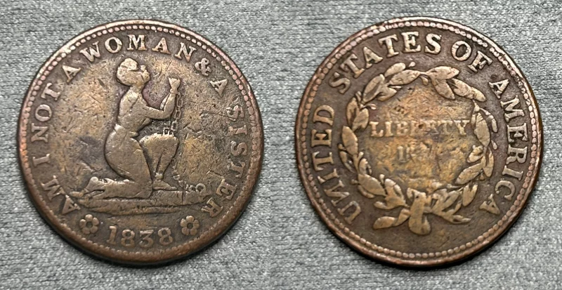
The Journal also drew a “mournful” comparison between the reverse design of the kneeling woman holding the distaff and spindle and the well-known “Am I Not a Woman and a Sister?” anti-slavery Hard Times Token. Surely, the Board felt vindicated by that line – although there’s no evidence Palmer or anyone else affiliated with them ever wrote to the Mint to say: “See? I told you we should gone with the building on the reverse.”
1838 HT-81 “Am I Not A Woman & A Sister?” (Image via me)
Sales figures, meanwhile, were disappointing. Of the 40,000 coins minted, a little more than half (21,180) ended up selling. According to NGC, the quarter’s sales were cannibalized by the Columbian Expo half dollar, which sold for the same price and was more widely available at the fair (5 million Columbian Expo half dollars were minted – 125 times as many compared to the Isabella quarter). While it didn’t come close to selling out, Coin Week points out that the quarters, which sold for $1 each, ended up being profitable for the Board. A $20,000-plus stream of revenue may not have been much, but it was double the original federal appropriation awarded to the Board. Of the remaining 19,000-plus quarters, approximately 15,000 went back to the Mint for melting.
1893 Columbian Expo Half Dollar. (Image via me)
In recent years, the coin’s reputation has been rehabilitated and has become a highly sought-after collector’s item. Contemporary reviewers have praised its quaint design and its uniqueness among U.S. commemorative coins (until the modern commemoratives came around, it held the distinction as the only commemorative quarter in U.S. history – as well as the only one to depict a foreign monarch). Even the reverse of the coin has been somewhat vindicated. Art historian Cornelius Vermeule argued that the design wasn’t necessarily evocative of the anti-slavery token and even traced elements of it back to antiquities. “[S]ome details of drapery to a servant girl from the East Pediment of the Temple of Zeus at Olympia, work of about 460 B.C. with additions and revisions in the first or second centuries A.D.,” he wrote.
I love the design and how it distinguishes this coin from other early commemoratives. Too many coins from that era have a generic male bust on the obverse and either an eagle or state symbol on the reverse. Because of the relative scarcity of this coin, buying one wasn’t cheap (this one had been cleaned, which lowered its value, but it still ended up costing over $100). The price tag was worth it, as this has become one of my favorite coins.
So I guess the lesson here is that I should buy more modern commemoratives – even those that I think are ugly. After all, maybe they’ll skyrocket in value in 100 years…


,_exterior,_springtime_2.jpg)


 1838 HT-81 “Am I Not A Woman & A Sister?” (Image via me)
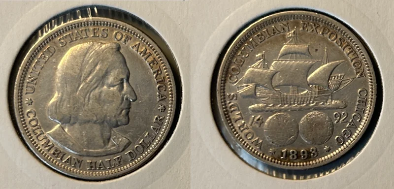 1893 Columbian Expo Half Dollar. (Image via me)

