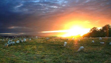
The Carnac stones (Breton: Steudadoù Karnag) are an exceptionally dense collection of megalithic sites near the south coast of Brittany in northwestern France, consisting of stone alignments (rows), dolmens (stone tombs), tumuli (burial mounds) and single menhirs (standing stones). More than 3,000 prehistoric standing stones were hewn from local granite and erected by the pre-Celtic people of Brittany and form the largest such collection in the world.[1] Most of the stones are within the Breton municipality of Carnac, but some to the east are within neighboring La Trinité-sur-Mer. The stones were erected at some stage during the Neolithic period, probably around 3300 BC, but some may date to as early as 4500 BC.[2]
Although the stones date from 4500–3300 BC, modern beliefs associated them with 1st century AD Roman and later Christian occupations. A Christian legend associated with the stones held that they were pagan soldiers in pursuit of Pope Cornelius when he turned them to stone.[3][4][5] Brittany has its own local versions of the Arthurian cycle. Local tradition similarly claims that the reason they stand in such perfectly straight lines is that they are a Roman legion turned to stone by Merlin.
In recent centuries, many of the sites have been neglected, with reports of dolmens being used as sheep shelters, chicken sheds or even ovens.[6] Even more commonly, stones have been removed to make way for roads, or as building materials. The continuing management of the sites remains a controversial topic.[1][7]
According to Neil Oliver's BBC documentary A History of Ancient Britain,[8] the alignments would have been built by hunter-gatherer people ("These weren't erected by Neolithic farmers, but by Mesolithic hunters"). That would place them in a different category from Stonehenge in England, which has been claimed to be the work of Early European Farmers.[9] The question of which people Carnac stones are to be attributed to is still debated.[10]
Model of the Ménec alignmentModel of the Kermario alignmentModel of the Kerlescan alignment
There are three major groups of stone rows – Ménec, Kermario and Kerlescan. They may have once formed a single group but have been split up as stones were removed for other purposes.
The standing stones are made of weathered granite from local outcroppings that once extensively covered the area.[11]
Eleven converging rows of menhirs stretching for 1,165 by 100 metres (3,822 by 328 feet). There are what Alexander Thom considered to be the remains of stone circles at either end. According to the tourist office there is a "cromlech containing 71 stone blocks" at the western end and a very ruined cromlech at the eastern end. The largest stones, around 4 metres (13 feet) high, are at the wider, western end; the stones then become as small as 0.6 metres (2 feet 0 inches) high along the length of the alignment before growing in height again toward the extreme eastern end.
This fan-like layout recurs a little further along to the east in the Kermario (House of the Dead)[12] alignment. It consists of 1029 stones[13] in ten columns, about 1,300 m (4,300 ft) in length.[citation needed] A stone circle to the east end, where the stones are shorter, was revealed by aerial photography.[14]
A smaller group of 555 stones, further to the east of the other two sites. It is composed of 13 lines with a total length of about 800 metres (2,600 ft), ranging in height from 80 cm (2 ft 7 in) to 4 m (13 ft).[15] At the extreme west, where the stones are tallest, there is a stone circle which has 39 stones. There may also be another stone circle to the north.[citation needed]
A much smaller group, further east again of Kerlescan, falling within the commune of La Trinité-sur-Mer. These are now set in woods, and most are covered with moss and ivy.[16]
There are several tumuli, mounds of earth built up over a grave. In this area, they generally feature a passage leading to a central chamber which once held neolithic artifacts.
Three exceptionally large burial mounds are known from the Carnac and Morbihan area, dating from the mid-5th millennium BC and known collectively as 'Carnacéen tumuli': Saint-Michel, Tumiac and Mané-er-Hroëk.[17] Each of these tumuli contained a megalithic burial chamber, containing the burial of only one individual, along with numerous large polished stone axeheads, stone arm-rings, and jewellery made from callaïs (variscite and turquoise).[18] Scientific analyses have shown that many of the axeheads are made of jade from the Italian Alps, whilst the callaïs was imported from south-western Iberia.[19][20] Archaeological evidence indicates that the callaïs was brought from Iberia by boat, across the Bay of Biscay, rather than along the coast or overland.[19] Some of the Carnacéen jade axeheads are up to 46 cm in length and may have taken over a thousand hours to produce, on top of the time required to quarry the material and transport it to Carnac.[21] The extraordinary nature of these burials, the scale of the tumuli, the logistics and effort involved, all indicate that these were the burials of extremely important elite individuals, that some researchers have described as "divine kings".[22][23][24] The large-scale effort and organisation involved in the construction of megalithic monuments, such as the 20.6 metre-tall Grand Menhir of Er Grah, further suggests the existence of rulers or kings in the Carnac and Morbihan region.[25][26][27] A similar situation has been described for the later megalithic culture in Ireland, which shows some close similarities to the megalithic culture in Brittany.[28] Based on archaeological, DNA and ethnographic evidence it has been suggested that an elite male buried in the Newgrange passage grave, c. 3200 BC, may have been a "god-king" and part of a "dynastic elite".[29] Similarities have also been noted with the Michelsberg culture in northeastern France and Germany (c. 4200 BC), which featured large tumulus burials within fortified settlements and the use of Alpine jade axes, all associated with the emergence of "high-ranking elites".[30][31] Engravings on megalithic monuments in Carnac also feature numerous depictions of objects interpreted as symbols of authority and power, such as curved throwing weapons, axes and sceptres.[32][33]
The Carnacéen tumuli were contemporary with the rich burials of the Varna culture in Bulgaria (c. 4500 BC), which contained more gold than all excavated sites from the rest of the world combined in the 5th millennium BC.[34] The Varna burials attest to the existence of powerful elites in southeastern Europe at the same time as they appear in Carnac.[35] Grave 43 of the Varna necropolis, which contained a single male buried with a sceptre and numerous gold ornaments, also contained an Alpine jade axehead.[36][37]
The tumulus of Saint-Michel was constructed between 5000 BCE and 3400 BCE. At its base it is 125 by 60 m (410 by 197 ft), and is 12 m (39 ft) high. It required 35,000 cubic metres (46,000 cu yd) of stone and earth. Its function was a tomb for the members of the ruling class. It contained various funerary objects, such as 15 stone chests, large jade axes, pottery, and callaïs jewellery, most of which are currently held by the Museum of Prehistory of Carnac.[38] It was excavated in 1862 by René Galles with a series of vertical pits, digging down 8 m (26 ft). Le Rouzic also excavated it between 1900 and 1907, discovering the tomb and the stone chests.[39]
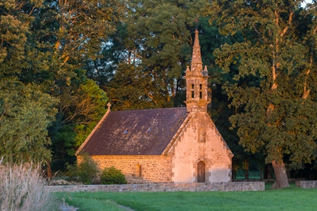
A chapel was built on top in 1663 and was rebuilt in 1813, before being destroyed in 1923. The current building is an identical reconstruction of the 1663 chapel, built in 1926.
The tumulus of Tumiac is located in Arzon, in the Rhuys peninsula, south of the Gulf of Morbihan. It is also known as 'Caesar's mound' because, according to local legend, it served as an observatory for Julius Caesar during his war against the Veneti in 56 BC.
The site was excavated in 1853. The crater visible at the top of the tumulus corresponds to the vertical hole made at the time for its exploration. It was the subject of new excavations and work in 1934, which brought to light several secondary burials.
The tumulus, circular/elliptical in shape, is made up of layers of clay. It measures 50 m in diameter and 15 m in height. It contains a central rectangular burial chamber 4.40 m long, 2.40 m wide and 1.75 m high. This chamber is made up of three monolithic supports and is covered with a quartz slab 4.80 m long. It had a wooden floor and two engraved side slabs. The funerary chamber contained rich furniture consisting of 11 jadeite axes, 26 fibrolite axes and 249 callaïs beads. These objects are kept in the Archaeological Museum of Vannes. According to carbon-14 dating, the tumulus of Tumiac was erected between 4790 and 4530 BC.
The tumulus of Tumiac has been classified as a historical monument since 1923.
The Tumulus of Mané-er-Hroëk (also known as the Tumulus du Ruyk) is located in Locmariaquer, Morbihan, immediately west of the hamlet of Er-Hroueg and about 1 km northeast of the Pierres Plates dolmen.
The tumulus comprises a rectangular burial vault of about 5 m by 3 m, covered with two roofing slabs, supporting a mound about 100 m long and 60 m wide. The tumulus rises to approximately 15 m above sea level, or almost 8 m above the natural ground. The current entrance, with a staircase, is a modern addition. An engraved stele, found broken into three pieces, stands next to the entrance.
During your holidays in Carnac, discover the town’s religious heritage: its six chapels will take you on a journey through the centuries.
CHAPEL OFSt Michel
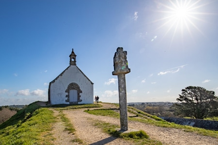
The Chapel of Saint Michel de Carnac was rebuilt around 1813 and again in 1925 on the same plans as the original chapel dating from 1664. It is located on the highest point of the town, the tumulus hill. Below is St Michel devotional fountain. Women whose husbands were at sea, used to sweep the chapel in the direction they wanted to see the wind blow. Then they would to pray at the fountain and drink the water. St Michel’s saints day is in September. There is an orientation table at the high point of the hill.
Climb to the top of the tumulus and admire the breathtaking views of the ocean and islands.
CHAPEL OFSt Colomban
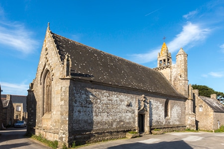
The Chapel of Saint Colomban, built in the flamboyant Gothic style, dates from the end of the sixteenth century. It is consecrated to the Irish monk Saint Columba, the patron saint of fools. To the east of the village, with its granite houses, is the fountain of Saint Colomban, which has two drinking pools. The wash house was a meeting place for the village women. South of the village, by the sea, are two chimneys, the remains of a forge.
The chapel is open all year round from 10 am to 6 pm. Entrance is free.
CHAPEL OFKergroix
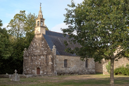
The Kergroix chapel dates back to the 16th century, although it was rebuilt in 1951. The Forgiveness of Our Lady of the Cross is celebrated in September. The chapel is open to the public all summer.
CHAPEL OF la Madeleine
The site of the chapel was once a leper colony. The present chapel was rebuilt in 1976. It is open and tended by local people in the summer. The most important service takes place in July. Next to the chapel, you will discover the fountain, the source of which is said to cure fever and skin diseases.
Continue your walk towards the Chapel of Hahon and the Chapel of Coet, both to the North of Carnac.
During your holidays in Carnac, discover the town’s religious heritage: its six chapels will take you on a journey through the centuries.
CHAPEL OF St Michel
The Chapel of Saint Michel de Carnac was rebuilt around 1813 and again in 1925 on the same plans as the original chapel dating from 1664. It is located on the highest point of the town, the tumulus hill. Below is St Michel devotional fountain. Women whose husbands were at sea, used to sweep the chapel in the direction they wanted to see the wind blow. Then they would to pray at the fountain and drink the water. St Michel’s saints day is in September. There is an orientation table at the high point of the hill.
Climb to the top of the tumulus and admire the breathtaking views of the ocean and islands.
CHAPEL OF St Colomban
The Chapel of Saint Colomban, built in the flamboyant Gothic style, dates from the end of the sixteenth century. It is consecrated to the Irish monk Saint Columba, the patron saint of fools. To the east of the village, with its granite houses, is the fountain of Saint Colomban, which has two drinking pools. The wash house was a meeting place for the village women. South of the village, by the sea, are two chimneys, the remains of a forge.
The chapel is open all year round from 10 am to 6 pm. Entrance is free.
CHAPEL OF Kergroix
The Kergroix chapel dates back to the 16th century, although it was rebuilt in 1951. The Forgiveness of Our Lady of the Cross is celebrated in September. The chapel is open to the public all summer.
CHAPEL OF la Madeleine
The site of the chapel was once a leper colony. The present chapel was rebuilt in 1976. It is open and tended by local people in the summer. The most important service takes place in July. Next to the chapel, you will discover the fountain, the source of which is said to cure fever and skin diseases.
Continue your walk towards the Chapel of Hahon and the Chapel of Coet, both to the North of Carnac.
In the NW of France. Carnacs monuments date back to prehistoric times and are a popular tourist attraction. They provide insight into the ancient history, the neolithic age, and the culture of the region.
These monuments are among the most famous and extensive megalithic sites in the world, and are estimated to date back to the neolithic period.
More than 3,000 prehistoric standing stones were erected by the pre-Celtic people of Brittany They form the largest such collection in the world. (1)
From local granite, ancient ancestors, erected them Probably around 3300 BC but some may be as early as 4500BC. (2)
Different people have different stories Some associate the stones with 1st century AD romans, and later Christian occupations. Including that soldiers were turned to stone in pursuit of the pope. (3)(4)(5)
More commonly, local tradition claims. A legion was turned to stone by the popular wizard Merlin From King Arthur legend.
The questions of the carnac stones are still being debated.
Currently at, and around the main site. The 3 major groups of stone rows are: Ménec, Kermario and Kerlescan
Ménec alignments have eleven rows of menhirs. 1,165 by 100 metres; or 3,822 by 328 feet Some considered stone circles made at either end. Especially in the west. The largest stones are 13 feet or 4 meters. It lowers a bit in the middle and rises again in the extreme eastern end.
Kermario alignment is 10 columns. Spread about 1300 meters or 4300 feet long More of a fan like layout. 1029 stones are found in 10 columns. It is also believed a stone circle was here. In the east. Revealed by satellite photography. (6)
Kerlescan alignments is 13 lines. With total length around 800 meters (or, 2600 ft) A smaller group of 555 stones. Exists further to the east of the other two sites. The stones here also vary in size from about 80cm (or 2 foot 7 inches) to 4 meters, or 13 feet. (7)
Petit-Ménec alignments are much smaller and covered in the woods (8)
There are also three known tumuli They are: Carnacéen, Saint-Michel, Tumiac and Mané-er-Hroëk (9)
From the Carnac and Morbihan area. Carnacéen maybe around 7000 years old Containing a burial chamber, and one individual. Callaïs jewelry, stone arm rings and polished stone axe heads from the Italian alps were found too. Because jade is a hard stone. The axe heads 46 cm in length. Would have taken over one thousand hours to produce.
Saint-Michel is a tumulus constructed between around 7000 and 5400 years ago At its base it is 125 metres or 410 ft long; 50 metres (160 ft) wide; and, 10 metres or 33 ft high. (10). To produce. It required 35,000 cubic metres (46,000 cu yd) of stones and earth.
With its known neolithic and prehistoric significance. A chapel was built on top of the Tumulus in 1663 The current building is an identical reconstruction of the 1663 chapel, built in 1926.
Tumiac is known as Caesars mound because of its location as a observation tower during the Veneti war South of the Gulf of Morbihan. In 1853 archaeologists excavated a site, and carbon 14 dated it to 4790 or 4530 BC. The tumulus, elliptical and circular in shape. Is made of layers of clay. It is 50 meters wide; and, 15 meters in height. It contains several rectangular burial chambers. With monolithic supports and quartz slabs. It also had jadeite axes. Firbolite azes and callaïs beads.
Mané-er-Hroëk is a rectangular burial vault of about 5m by 3m. Covered with two slabs. On a 100x60mx8m mound Many stone axes, and jewelry including callaïs were found here. Its modern entrance is an addition.
There are dolmens in the area too They are: Er-Roc’h-Feutet, La madeleine, Kercado, Mané Brizil, Kerlescan, Mané-Kerioned, Crucuno and Crucuno stone rectangle
Er-Roc’h-Feutet An enormous cover stone covers the chamber, and the passageway still has its capstones. Near La Madeleine.
La Madeleine is 12x5m with a broken capstone
Kercado is almost 100 feet wide. It was previously surrounded by stone circle Down its 21 foot main passageway. Neophite gems, beads, human and animal teeth and numerous artifacts were found. Believed to be constructed around 4600 BC.
Mané Brizil
Kerlescan A roughly rectangular mound, with a capstone remaining, and entry from the south.
Kermarquer On a small hill, has two separate chambers.
Mané-Kerioned is a unique group of 3 dolmens. Once covered by a tumulus
Crucuno is a classic dolmen. 1.8 meter pillars supporting a 40 ton tablestone
Crucuno stone rectangle has 21 menhirs. From about 3 to 8 feet height
Other menhirs, and formations that do not fit into categories There’s also the manio quadrilateral, and manio giant
Manio quadrilateral, Is 121 feet long and 23-33 feet wide Believed to have a central mound. Or, originally be a “tertre tumulus”.
Manio giant is near the quadrilateral. A single massive menhir Over 6.5 m or 21 feet tall. It overlooks the Kerlescan alignment.
In 1796, La Tour d’Auvergne attributed the stones to druidic gatherings.
Others said they were stars or planetary formations. And, some that they were used for workouts, and team building exercises.
Did you know? In 1834 Englishmen Francis Ronalds and Alexander Blair drew them. In Sketches at Carnac (Brittany). A popular book for the time.
In the 1860s, extensive excavation was performed It was James Miln (1819–1881), a Scottish archaeologist and historian. He reported that fewer than 700 of the 3,000 stones were still standing, and that the sites should be further investigated. Eventually he engaged Zacharie Le Rouzic (1864–1939), a local boy, as his assistant.
The Musée de Préhistoire is now named in boths honour
Displaying the ‘largest collection of prehistoric exhibits’. Will over 6600 displays, from 136 sites.
The exact purpose and cultural significance of Carnacs megalithic monuments remain topics of scholarly study and debate. They’re a testament to the skills and beliefs of the prehistoric people who constructed them. It continues to attract tourists, and historians from around the world. Interested in understanding our historical and cultural significance.
The Carnac stones (Breton: Steudadoù Karnag) are an exceptionally dense collection of megalithic sites around the village of Carnac in Brittany, consisting of alignments, dolmens, tumuli and single menhirs. More than 3,000 prehistoric standing stones were hewn from local rock and erected by the pre-Celtic people of Brittany, and form the largest such collection in the world. Most of the stones are within the Breton village of Carnac, but some to the east are within La Trinité-sur-Mer. The stones were erected at some stage during the Neolithic period, probably around 3300 BCE, but some may date to as early as 4500 BCE.
Although the stones date from 4500 BCE, modern myths were formed which resulted from 1st century AD Roman and later Christian occupations, such as Saint Cornelius a Christian myth associated with the stones held that they were pagan soldiers in pursuit of Pope Cornelius when he turned them to stone. Brittany has its own local versions of the Arthurian cycle. Local tradition claims that the reason they stand in such perfectly straight lines is that they are a Roman legion turned to stone by Merlin.
In recent centuries, many of the sites have been neglected, with reports of dolmens being used as sheep shelters, chicken sheds or even ovens. Even more commonly, stones have been removed to make way for roads, or as building materials. The continuing management of the sites remains a controversial topic.
Alignments
There are three major groups of stone rows — Ménec, Kermario and Kerlescan — which may have once formed a single group, but have been split up as stones were removed for other purposes.
Ménec Alignments
Eleven converging rows of menhirs stretching for 1,165 by 100 metres (3,822 by 328 feet). There are what Alexander Thom considered to be the remains of stone circles at either end. According to the tourist office there is a "cromlech containing 71 stone blocks" at the western end and a very ruined cromlech at the eastern end. The largest stones, around 4 metres (13 feet) high, are at the wider, western end; the stones then become as small as 0.6 metres (2 feet 0 inches) high along the length of the alignment before growing in height again toward the extreme eastern end.
Kermario Alignment
This fan-like layout recurs a little further along to the east in the Kermario (House of the Dead) alignment. It consists of 1029 stones in ten columns, about 1,300 m (4,300 ft) in length. A stone circle to the east end, where the stones are shorter, was revealed by aerial photography.
Kerlescan Alignments
A smaller group of 555 stones, further to the east of the other two sites. It is composed of 13 lines with a total length of about 800 metres (2,600 ft), ranging in height from 80 cm (2 ft 7 in) to 4 m (13 ft). At the extreme west, where the stones are tallest, there is a stone circle which has 39 stones. There may also be another stone circle to the north.
Petit-Ménec Alignments
A much smaller group, further east again of Kerlescan, falling within the commune of La Trinité-sur-Mer. These are now set in woods, and most are covered with moss and ivy.
Tumuli
There are several tumuli, mounds of earth built up over a grave. In this area, they generally feature a passage leading to a central chamber which once held neolithic artefacts.
Saint-Michel
The tumulus of Saint-Michel was constructed between 5000 BC and 3400 BC. At its base it is 125 by 60 m (410 by 197 ft), and is 12 m (39 ft) high. It required 35,000 cubic metres (46,000 cu yd) of stone and earth. Its function was the same as that of the pyramids of Egypt: a tomb for the members of the ruling class. It contained various funerary objects, such as 15 stone chests, pottery, jewellery, most of which are currently held by the Museum of Prehistory of Carnac. It was excavated in 1862 by René Galles with a series of vertical pits, digging down 8 m (26 ft). Le Rouzic also excavated it between 1900 and 1907 discovering the tomb and the stone chests.
A chapel was built on top in 1663 but was rebuilt in 1813, before being destroyed in 1923. The current building is an identical reconstruction of the 1663 chapel, built in 1926.
Moustoir 47.6119°N 3.0608°W
Also known as Er Mané, it is a chamber tomb 85 m (279 ft) long, 35 m (115 ft) wide, and 5 m (16 ft) high. It has a dolmen at the west end, and two tombs at the east end A small menhir, approximately 3 m (10 ft) high, is nearby.
Dolmens
There are several dolmens scattered around the area. These dolmens are generally considered to have been tombs; however, the acidic soil of Brittany has eroded away the bones. They were constructed with several large stones supporting a capstone, then buried under a mound of earth. In many cases, the mound is no longer present, sometimes due to archeological excavation, and only the large stones remain, in various states of ruin.
Er-Roc'h-Feutet
North, near the Chapelle de La Madeleine. Has a completely covered roof.
La Madeleine 47.6208°N 3.0482°W
A large dolmen measuring 12 by 5 m (39 by 16 ft), with a 5 m (16 ft) long broken capstone. It is named after the nearby Chapelle de La Madeleine, which is still used.
Kercado
A rare dolmen still covered by its original cairn. South of the Kermario alignments, it is 25 to 30 metres (82–98 ft) wide, 5 m (16 ft) high, and has a small menhir on top. Previously surrounded by a circle of small menhirs 4 m (13 ft) out, the main passage is 6.5 m (21 ft) long and leads to a large chamber where numerous artifacts were found, including axes, arrowheads, some animal and human teeth, some pearls and sherds, and 26 beads of a unique bluish Nephrite gem. It has some Megalithic art carved on its inner surfaces in the form of serpentines and a human-sized double-axe symbol carved in the underside of its main roof slab. In ancient cultures, the axe and more precisely the bi-pennis used to represent the lightning powers of divinity. It was constructed around 4600 BC and used for approximately 3,000 years.
Mané Brizil
Kerlescan
A roughly rectangular mound, with only one capstone remaining. It is aligned east-to-west, with a passage entrance to the south.
Kermarquer
On a small hill, has two separate chambers.
Mané-Kerioned (Pixies' Mound or Grotte de Grionnec)
A group of three dolmens with layout unique in Brittany, once covered by a tumulus. Whereas most groups of dolmens are parallel, these are arranged in a horseshoe. The largest of the three is at the east, 11 metres (36 ft).
Crucuno
A "classic" dolmen, with a 40-tonne (44-short-ton), 7.6-metre (24 ft 11 in) tablestone resting on pillars roughly 1.8 m (5 ft 11 in) high. Prior to 1900, it was connected by a passage making it 24 m (79 ft) long.
Crucuno Stone Rectangle 47.625°N 3.121667°W
A classic 3, 4, 5 rectangle of 21 menhirs varying in height from 0.91 metres (3.0 ft) to 2.4 metres (7.9 ft) that is aligned along its diagonal to the midsummer sunrise. Alexander Thom suggested it measured forty by thirty of his megalithic yards.
Other Formations
There are some individual menhirs and at least one other formation which do not fit into the above categories.
Manio quadrilateral
An arrangement of stones to form the perimeter of a large rectangle. Originally a "tertre tumulus" with a central mound, it is 37 m (121 ft) long, and aligned to east of northeast. The quadrilateral is 10 m (33 ft) wide to the east, but only 7 m (23 ft) wide at the west.
Manio giant 47.6034°N 3.056°W
Near the quadrilateral is a single massive menhir, now known as the "Giant". Over 6.5 m (21 ft) tall, it was re-erected around 1900 by Zacharie Le Rouzic, and overlooks the nearby Kerlescan alignment.
Excavation and Analysis
From the 1720s increasing interest was shown in these features. In 1796, for example, La Tour d'Auvergne attributed them to druidic gatherings. In 1805, A. Maudet de Penhoët claimed they represented stars in the sky.
Englishmen Francis Ronalds and Alexander Blair made a detailed survey of the stones in 1834. Ronalds created the first accurate drawings of many of them with his patented perspective tracing instrument, which were printed in a book Sketches at Carnac (Brittany) in 1834.
Miln and Le Rouzic
The first extensive excavation was performed in the 1860s by Scottish antiquary James Miln (1819–1881), who reported that by then fewer than 700 of the 3,000 stones were still standing. Towards 1875, Miln engaged a local boy, Zacharie Le Rouzic (fr) (1864–1939), as his assistant, and Zacharie learnt archaeology on the job. After Miln's death, he left the results of his excavations to the town of Carnac, and the James Miln Museum was established there by his brother Robert to house the artefacts. Zacharie became the director of the Museum and, although self-taught, became an internationally recognised expert on megaliths in the region. He too left the results of his work to the town, and the museum is now named Le Musée de Préhistoire James Miln – Zacharie le Rouzic.
Other Theories
In 1887, H. de Cleuziou argued for a connection between the rows of stones and the directions of sunsets at the solstices.
Among more recent studies, Alexander Thom worked with his son Archie from 1970 to 1974 to carry out a detailed survey of the Carnac alignments, and produced a series of papers on the astronomical alignments of the stones as well as statistical analysis supporting his concept of the megalithic yard. Thom's megalithic yard has been challenged.
There are also general theories on the use of the stones as astronomical observatories, as has been claimed for Stonehenge. According to one such theory, the massive menhir at nearby Locmariaquer was linked to the alignments for such a purpose.
Los alineamientos megalíticos de Carnac son uno de los grandes misterios, no resueltos de manera definitiva, que nos deja la cultura megalítica. Se tiende a pensar que se trata de varios lugares distintos, donde los alineamientos son propios, pero in situ, y sobre todo viendo el plano de conjunto, pronto se aprecia que realmente se trata de un gran conjunto único, aunque discontínuo, de piedras alineadas, de variable tamaño, entre las que hay algunas bastante grandes. Carnac, protegida de los vientos del oeste por la península de Quiberon (el término Presque-isle es aquí particularmente apropiado), tiene la mayor concentración de megalitos conocida en el mundo, con más de 3.000 piedras alineadas, y también el monumento prehistórico más extenso del mundo. Su propio nombre, derivado del céltico karn (roca), parece relacionado con ellas, pero no deberiamos olvidar sus espléndidas playas, que la han convertido en uno de los lugares de veraneo más frecuentados en el golfo de Morbihan y han hecho que, al referirnos a esta población, debamos diferenciar entre Carnac-Ville y Carnac-Plage. El conjunto más importante es Le Menec, situado al oeste de la D119 y al norte de la D196, mientras que los conjuntos de Kermario, Manlio, Kerlescan y Petit Menec se disponen más al este y al sur de la D196. El pequeño conjunto de Toul-Chignant se sitúa frente a Le Menec justo al este de la D119. Actualmente se sabe que los menhires tienen tumbas y que todo el conjunto es una gran necrópolis, aunque sigue habiendo numerosas leyendas y teorías sobre diversos aspectos del grupo monumental, que en general no resisten un análisis profundo. El acceso directo a los megalitos está reservado desde que, en 1991, se construyó un cercado que protege buena parte de los conjuntos, por lo que la visita se hace por un acceso periférico que, sin embargo, permite una excelente visión de los monumentos. Nuestra ruta comienza en un pequeño aparcamiento situado en el lateral de la D196, al lado del yacimiento, del que está separado por una simple valla. Nos dirigimos primero hacia el este, hasta sobrepasar un muro de piedra que cierra la parte este del yacimiento. Algo más adelante está la carretera D119 y, entre medias, hay un pequeño acúmulo de menhires, posible resto de un antiguo cromlech, que se describe como en penoso estado en las guías consultadas. Justo tras pasar la citada carretera encontramos un acumulo menor de menhires, que forman el alineamiento de Toul-Chignant. Siguiendo unos pocos centenares de metros hacia el este por la D196, tras un par de pequeños aparcamientos, estaremos ya en los alineamientos de Kermario, que se continúan casi sin interrupción con los de Manio, Kerlescán y Petit Menec. No iremos a estos. Desde el alineamiento de Toul-Chignant continuamos hacia el norte, en busca de la Allée des Alouettes, donde giramos hacia el oeste para entrar en el camino de peatones que rodea los alineamientos, pasando por una pequeña alameda, que pronto sale a un sendero de tierra que sigue al lado de los megalitos, de los que está separado una corta distancia por una alambrada y poco más. Los menhires de la parte oeste parecen estar en mejores condiciones, parecen más altos e incluso más próximos en esta parte. Al final encontramos unas casas y, casi al lado, un cromlech bien conservado. Poco después salimos a la carretera D196 y, casi de inmediato, arranca un sendero, con carril bici, que permite hacer el regreso entre la carretera y el alineamiento hacia el lugar donde hemos dejado el coche. En el camino pasamos por un pequeño anfiteatro de tierra, que suponemos preparado para las presentaciones y una moderna casa grande, la Maison des Megalithes, pero el corto sendero es más que suficiente para hacerse una buena idea de lo que son los alineamientos, y la escasa distancia que separa al visitante de los megalitos parece más que suficiente para su protección, siempre que no se intente intencionadamente vandalizarlos.
Para comenzar, hay que decir que este monumento, o mejor dicho, grupo de monumentos prehistóricos, construidos entre el quinto y el tercer milenio a.C., se sitúan muy cerca del pequeño y pintoresco pueblo de Carnac, localizado en la Bretaña francesa. Y están considerados, en su conjunto, como uno los más grandes del mundo de este tipo, ya que sumando todo el espacio que ocupan, estos abarcan la nada desdeñable cifra de varios kilómetros cuadrados.
En cuanto a su nombre, el uso del término “alineamientos” no es casual. Pues este hace referencia a su disposición sobre el terreno, formando larguísimas hileras de menhires (piedras alargadas), que en algunos casos es superior a los 1000 metros. Unas hileras que acaban flanqueadas, por ambos lados, por varios círculos de piedras, más pequeños, al estilo de Stonehenge. En este sentido, en el caso de Carnac, los alineamientos son cuatro en total, y cada uno tiene un nombre propio: Le Menec, Kermario, Kerlescan y Petit Menec. Siendo los dos primeros los más famosos, visitados e importantes.
De hecho, el de Le Menec destaca porque tiene, nada más y nada menos que 1099 menhires colocados en once filas que abarcan 100 metros de ancho y 1200 de largo, con la particularidad de que están ordenados de más alto a más bajito. Y el de Kermario, situado muy cerca, es reconocido no por la cantidad de menhires, que también se aproxima a los 1000, si no por la altura de alguno de ellos, que alcanza en algunos casos los 7 metros de altura. Algo que impresiona, pues conviene recordar que una piedra de estas características pesa fácilmente varias toneladas y hace más espectacular si cabe, su transporte y posterior levantamiento.
Le Menec - Imagen de uno de los alineamientos de Carnac, concretamente Le Menec. Fuente: Wikimedia Commons.
Descrito el lugar, ahora la pregunta es obvia: ¿qué función o qué finalidad tuvieron esas alineaciones de piedras? Pues a diferencia de otros emplazamientos neolíticos realmente conocidos es el caso de Stonehenge (localizado cerca de Amesbury, en el suroeste de Inglaterra) donde parece haber cierto quórum, en el caso de Carnac, su uso sigue siendo un asunto que genera bastante debate aún hoy en día, pues no existe ninguna teoría dominante y ampliamente aceptada entre los arqueólogos y prehistoriadores.
De hecho, la más antigua que se propuso data del mismísimo siglo XVIII, cuando el escritor francés Jacques Cambry planteó, fruto de la gran influencia en él de los mitos locales, que el lugar fue una especie de observatorio astronómico usado por los druidas en sus rituales y celebraciones. Sin embargo, para las fechas en las que se construyó, que repito, fue entre el quinto y el tercer milenio a.C., la cultura druídica aún no existía. De hecho, estaba bastante lejos de existir, ya que la referencia más antigua que se tiene de estos archiconocidos sacerdotes celtas data del año 200 a.C. Por lo que esta opción quedó descartada.
Otra, propuesta durante la década de los 70 del pasado siglo XX por un ingeniero británico afirmaba que estos alineamientos pudieron guardar una relación directa con algunos eventos astronómicos importantes del año como es el caso de los solsticios o los equinoccios, ya que la proximidad de zonas fértiles al lugar, seguramente tuvo que ver con su construcción. No obstante, hay que decir que la gran mayoría de la comunidad científica ha descartado esta opción ya que no se ha encontrado vínculo entre dichos monumentos y las fechas simbólicas propuestas como sí ha sucedido en otros casos.
Además de las anteriores, aunque sea solo por curiosidad, debéis saber que han existido otras muchísimo más extravagantes. Como por ejemplo las que afirmaron que el los menhires eran una especie de balizas para la navegación y aterrizaje de naves espaciales, las que proponían que eran restos de lo que dejó tras de sí la destrucción provocada por el diluvio universal, o la que apostaba porque las piedras eran restos fósiles de una gigantesca serpiente que habría habitado esa zona de Francia hace millones de años.
A modo de conclusión, teorías fantásticas y locas aparte, lo que se cree actualmente es que su función en el pasado tuvo que estar directamente relacionada con las creencias o la religión de estos primitivos habitantes de la zona, apostando muchos expertos por la idea de que pudo estar relacionada de alguna forma con diferentes cultos telúricos, es decir, los relacionados con las fuerzas de la naturaleza.
Referencias:
Scarre, C. (2008). Nuevos enfoques para el estudio de monumentos megalíticos de Europa Occidental. Instituto Andaluz de Patrimonio Histórico. Nº67. pp 12-23.
Guilaine, J. (2011). Megalitos de Francia: distribución geográfica y cronología. Revista de prehistoria de Andalucía. Nº1. pp 77-101.
Seglins, V., Kukela, A. (2019). Stone studies of the Carnac alignements. 19th International Multidisciplinary Scientific GeoConference SGEM. University of Latvia.
Updated Monday, November 30: Just days after the “2001”-esque monolith appeared — and then vanished — in Utah, another similar-looking structure has appeared in Romania. According to the Daily Mail, the shiny triangular structure was discovered on Batca Doamnei Hill, in the city of Piatra Neamt, in northern Romania, facing what is known as the Holy Mountain.
Neamt Culture and Heritage official Rocsana Josanu told Euro Weekly that an investigation has begun. “We have started looking into the strange appearance of the monolith. It is on private property, but we still don’t know who the monolith’s owner is yet,” she said. “It is in a protected area on an archaeological site. Before installing something there, they needed permission from our institution, one that must then be approved by the Ministry of Culture.”
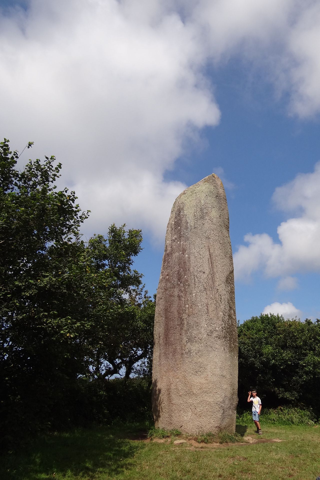
Erigé il y a environ 5 000 ans, le menhir de Kerloas est, jusqu’à preuve du contraire, le plus haut mégalithe actuellement debout. Il se trouve dans la campagne entre Plouarzel et Saint Renan, entouré de champs. L'environnement y est particulièrement calme.
. Kerloas dit "le bossu" ou "an tort" Sa hauteur au-dessus du sol naturel est de 9,50 m. Cependant, la hauteur originelle de ce monolithe était bien plus importante et devait dépasser les 10 m car, au XVIIIème siècle, il fut victime de la foudre qui en tronqua le sommet et les principaux morceaux qui gisaient à son pied furent utilisés, l’un pour la fabrication d’une auge, l’autre comme pierre d’entrée d'un champ. Cette dernière a été reconvertie aujourd’hui en ornement de pelouse à la ferme voisine.
. Kerloas, France's (and the world's) HIGHEST menhir The menhir's circumference, at ground level, is 6.20 m; at 1.20 m height it is 6.70 m; at 3.65 m it is 6.96 m, then the stone becomes thinner; at 5 m, the circumference is 6.45 m and at 6 m it is 5.95 m. The weight of the menhir is estimated at 150 tonnes.
. Les légendes Le menhir est encore surnommé par certains, le bossu ou an tort, à cause de deux bosses qui se situent de part et d'autre du menhir. Les deux saillies d'une trentaine de centimètres, étaient jadis l'objet d'un rite de fécondité. Les nouveaux mariés venaient nus se frotter le ventre contre les bosses du menhir, la femme d'un côté, le mari de l'autre. L'homme était certain d'avoir une descendance mle, la femme de gouverner son époux à sa guise.
In 1911, Guénin also reported that the megalith was reputed to have healing powers, and that sick people secretly came to rub themselves against the menhir's bumps in the hope of being cured. The same author also tells us that it was a "good woman" who brought it in her apron... Others attribute it to Gargantua, who placed it along with all the other granite blocks that dot the fields of Plouarzel, to take revenge on the parishioners for feeding him nothing but porridge. The legend also tells of a hidden treasure, visible only on Christmas Eve. The legend says that at the first stroke of midnight, the menhirs ran to the ocean to drink. But by the time the twelfth stroke sounded, they were already back in their place, stoic, immobile, impervious to the ravages of time. And woe betide the unwary who, dazzled by the unveiled riches, had forgotten the hour; they were crushed...
Classified as a historic monument on September 25, 1883
A menhir (/ˈmɛnhɪər/;[1] from Brittonic languages: maen or men, "stone" and hir or hîr, "long"[2]), standing stone, orthostat, or lith is a large upright stone, emplaced in the ground by humans, typically dating from the European middle Bronze Age. They can be found individually as monoliths, or as part of a group of similar stones. Menhirs' size can vary considerably, but they often taper toward the top.
Menhirs are found across Europe, Africa, and Asia, with a concentration in Western Europe, notably in Ireland, Great Britain, and Brittany. Theories concerning their purpose remain speculative, with hypotheses ranging from druidic rituals to territorial markers or elements of an ideological system. Some menhirs feature engravings, including anthropomorphic figures and symbols, and are often associated with ancient religious ceremonies and burial chambers.
The word menhir was adopted from French by 19th-century archaeologists. The introduction of the word into general archaeological usage has been attributed to the 18th-century French military officer Théophile Corret de la Tour d'Auvergne.[3] It is a combination of two words of the Breton language: maen and hir. In modern Welsh, they are described as maen hir, or "long stone". In modern Breton, the word peulvan is used, with peul meaning "stake" or "post" and van which is a soft mutation of the word maen which means "stone". In Germany and Scandinavia the word Bauta is used (German: Bautastein; Norwegian: bautastein) and this occasionally makes its way into English with the term "bauta stone".
Almost nothing is known of the social organization or religious beliefs of the people who erected the menhirs. Their language is also unknown. It is known, however, that they buried their dead and had the skills to grow crops, farm and make pottery, stone tools and jewelry. Identifying the purpose or use of menhirs remains speculative. Until recently, standing stones were associated with the Beaker people, who inhabited Europe during the European late Neolithic and early Bronze Age[4]—later third millennium BC, c. 2800–1800 BC. However, recent research into the age of megaliths in Brittany strongly suggests a far older origin, perhaps back to six to seven thousand years ago.[5]
During the European Middle Ages, standing stones were believed to have been built by the giants who lived before the biblical flood. Many of the megaliths were destroyed or defaced by early Christians; it is estimated that some 50,000 megaliths once stood in Northern Europe, where almost 10,000 now remain.[6] Menhirs have also been found in many other parts of the world.
Many menhirs are engraved with megalithic art, some with anthropomorphic features. Other common carvings are identified as images of stone axes, ploughs, shepherds' crooks, and yokes; and are named after these motifs. However, these identifications are not secure except for those of the stone axe images, and the names used to describe them are largely a matter of convenience. Some menhirs were broken up and incorporated into later passage graves, where they had new megalithic art carved with little regard for the previous pictures. It is not known if this re-use was deliberate or if the passage grave builders just saw menhirs as a convenient source of stone.[7]
Where menhirs appear in groups, often in a circular, oval, henge, or horseshoe formation, they are sometimes called megalithic monuments. These are sites of ancient religious ceremonies, sometimes containing burial chambers.[8] The exact function of menhirs has provoked more debate than practically any other issue in European prehistory. Over the centuries, they have variously been thought to have been used by druids for human sacrifice, used as territorial markers, or elements of a complex ideological system, used as mnemonic systems for oral cultures,[9] or functioning as early calendars.[10] Until the nineteenth century, antiquarians did not have substantial knowledge of prehistory, and their only reference points were provided by classical literature. The developments of radiocarbon dating and dendrochronology have significantly advanced scientific knowledge in this area.
Menhirs are widely distributed across Europe, Africa, and Asia, but are most numerous in Western Europe; particularly in Ireland, Great Britain, and Brittany, where there are about 50,000 examples,[11] and northwestern France, where there are some 1,200 further examples.[12] Standing stones are usually difficult to date. They were constructed during many different periods across prehistory as part of the larger megalithic cultures in Europe and near areas. Some menhirs stand next to buildings that have an early or current religious significance. One example is the South Zeal Menhir in Devon, which formed the basis for a 12th-century monastery built by lay monks. The monastery later became the Oxenham Arms hotel, at South Zeal, and the standing stone remains in place in the snug bar at the hotel.[13][14]
It is believed that practitioners of megalithic religions travelled via the sea, as the mass majority of menhirs are located on coasts, islands, and peninsulas.[15]
Medía aproximadamente 20 metros de largo pero actualmente está roto en cuatro partes. Cuando se erigió en el 4.500 a. C. alcanzaba unos 18,5 metros de altura sobre el suelo. Pesa unas 280 toneladas. Fue tallado y transportado desde varios kilómetros al lugar donde se emplazó, pero no se sabe aún con qué técnicas se hizo dicho traslado. Pero se cree que para levantarlo se utilizó una rampa de tierra y volcaron el menhir en una fosa y lo levantaron con ayuda de palancas y cabrias. Una vez levantado fue pulido con percutores de cuarzo para darle el aspecto actual. Se cree que en el emplazamiento, donde hay otras 18 fosas, se colocarían otros menhires formando una fila de menhires.
Réplica del posible alineamiento de los menhires de Locmariaquer
Permanent superhuman strength, provided by magical potion
Obelix (/ˈɒbəlɪks/; French: Obélix) is a cartoon character in the French comic book series Asterix. He works as a menhir sculptor and deliveryman as well as one of the primary defenders of the Gaulish village, and is Asterix's best friend. Obelix is noted for his obesity, the menhirs he carries around on his back and his superhuman strength. He fell into a cauldron of the Gauls' magic potion when he was a baby, causing him to be the only Gaul in Asterix's village who is in a permanent state of superhuman strength. Because of this already enormous strength, Obelix is not allowed to drink the magic potion ever again, a ban he regards as being tremendously unfair. Other characteristics are his simplemindedness, his love and care for his dog Dogmatix, his anger when someone refers to him as being "fat", his enthusiasm for hunting and eating wild boars, and beating up Romans. His catchphrase is: "Ils sont fous ces romains", which translates into "These Romans are crazy!", although he considers nearly every other nationality, even other Gauls, to be just as strange.
Obelix is Asterix's closest friend (they even have the same birthday—although this is inconsistent with the comic Obelix and Co., where only Obelix's birthday is celebrated). He generally works as a menhir delivery man. His passions in life are hanging around with Asterix, fighting, hunting and eating wild boar, making and carrying his menhirs, and beating up Roman legionaries (and occasionally collecting their helmets as trophies). Obelix has a little dog named Dogmatix (Fr. Idéfix), whom he adores. His parents live now in Condate (as seen in Asterix and the Actress) and his distant cousin Metallurgix, a famous golden sickle maker, lives in Lutetia (as seen in Asterix and the Golden Sickle).
Obelix's favourite food is roast wild boar which he usually hunts with Asterix, but he has a voracious appetite, and will try eating nearly anything with few exceptions; in Asterix and Obelix All at Sea and Asterix in Britain he seems not to like boiled boar. In fact, he eats nuts and oysters in the shell, and is completely oblivious to drugs, spicy food and poison, possibly due to the permanent effects of the magic potion. However, when he consumes alcohol, he gets very drunk very quickly, as seen for example in Asterix in Britain where he enjoys sampling different barrels of wine trying to find a barrel containing magic potion, or in Asterix and the Laurel Wreath, where both he and chief Vitalstatistix get drunk during a banquet, much to the shame of the latter's wife Impedimenta. Although he has his own house, Obelix is occasionally shown staying overnight at Asterix's.
Obelix owns the quarry where he chisels the menhirs himself. It is never directly stated what the menhirs are mostly used for aside from being Obelix’s personal blunt weapons. It is hinted that they are also just oversized knick-knacks; however they are probably a running-gag regarding the origins of the mystery surrounding Menhirs in ancient Europe, with the joke being that Obelix delivered them. Obelix usually trades the stones away for whatever he needs, resulting in the village having a literal field of menhirs.
Obelix is kind-hearted, but socially inept—possibly because his strength means that others have had to adapt to him instead of vice versa. He is still not completely aware of his own strength and almost invariably breaks any door he gently knocks on, making him a human battering ram. He is frequently used as a human battering ram for opening locked doors or breaking through walls. Similarly, he is unaware that others do not share his superhuman strength, and shows great surprise when others are crushed by what he calls "a little menhir", or when Asterix attempts to explain to him that a small dog like Dogmatix cannot lift a menhir. He also has little interest in subjects of formal education or intellectual pursuits, since sheer strength usually solves his problems; he generally leaves any decisions to Asterix. However, Obelix is not completely stupid. In Asterix and the Normans he deduces from various clues that Cacofonix the bard has gone to Lutetia to pursue a career in popular music: this unusual display of intelligence on Obelix's part surprises Getafix. He also surprises Asterix in Asterix and the Black Gold by reeling off a dictionary definition of wild boar in conversation (including the Latin taxonomical classification). He can also be quite dangerous when angered.
While cheerfully violent and enjoying a good fight, Obelix is far from brutal or sadistic: he tends to view fighting as a game and is generally friendly and polite (to the point of inappropriate courtesy) towards his opponents. He extends this benevolence even towards the Romans, whom he rarely seems to view as oppressors but more as less-willing participants in his rough-housing (The Romans themselves seem to view him as a terrifying ogre, whose infamy has spread across the entire Roman army). His other favored pastimes are dancing (which he apparently is very good at), and occasionally drinking goat's milk to excess (as he rarely imbibes in alcohol).
Like Asterix, Obelix is a bachelor, but he is easily smitten by a pretty face. He harbours a hopeless crush on Panacea, the daughter of Soporifix (one of the other villagers), and occasionally other young women, most notably Mrs. Geriatrix (which enrages her husband). However, one may think that he will eventually find a mate and have children since in Asterix and the Class Act, he is shown to be the founder of a long dynasty of French warriors that lasted well into the 20th century.[1]
Obelix's trademark phrase is "These Romans are crazy" ("Ils sont fous ces romains": in the Italian translation, it is "Sono pazzi questi Romani", which can be shortened to S.P.Q.R., Rome's motto), although he has applied a variant of it to nearly every group he's met in his travels: "These Britons are crazy", "These Corsicans are crazy", etc. This remark is followed by him tapping his forehead. It is a parody of the quote "These Gauls are crazy", which Julius Caesar famously said while describing the Gauls' fighting style during his conquest of the region.[citation needed]
Unlike the other villagers, Obelix has no need to drink the druidGetafix's magic potion that gives superhuman strength, because he fell into the cauldron as a baby and its effect on him became permanent. Obelix is tall and massive. He is about 6 feet 2 inches (188 cm)[citation needed] tall and he weighs more than 300 pounds (140 kg).[according to whom?] The story of that incident is told in How Obelix Fell into the Magic Potion When he was a Little Boy. Since this effect was not intended or expected, Getafix refuses to allow him even one more drop except under the most dire circumstances (either out of fear for his life, or fear for the lives of others should the inattentive and uncoordinated strongman become any stronger), which annoys Obelix greatly. (In Asterix and Obelix All at Sea, it is revealed that too much of the potion can turn the drinker to stone; exactly how much is not known, but a whole cauldron will certainly do the trick. This appears to only work on grown people as Obelix did not turn to stone as a baby, or may simply occur after drinking an excessive amount while still under the effects of a previous dose). However, in Asterix and Cleopatra, Getafix gives him a few drops to open a door in the Great Pyramid's Labyrinth but he comments that he does not see much difference between "before and after the potion" though this is presumably because Obelix is used to accomplishing any physical task with ease.
Although it has been clearly stated by both Getafix (in Asterix the Gaul) and Asterix (in Asterix and the Laurel Wreath) that the magic potion does NOT grant invulnerability (Getafix has a potion for that but it is only mentioned in Asterix the Gaul), meaning that they could be injured by the Romans in their fights but their raw strength generally prevents the Romans getting the chance to do so, the same does not seem to be true of Obelix. He does not even notice when attackers attempt to knock him unconscious with blows to the head, when Roman spearheads are stuck in his bottom in Asterix in Corsica or when anyone else attempts to harm him in any way. This may imply that Obelix, either by stupidity or ignorance, simply does not notice or react to the pain that should be inflicted, or that the potion has enhanced his overall strength, since it has been shown to increase the drinker's endurance allowing them to run faster, to such a point where his muscles allow him to effortlessly absorb the attacks in question. Most of the occasions where Obelix demonstrates invulnerability include him being attacked physically rather than with sharp objects, as in Asterix and the Magic Carpet, when an arrow accidentally hits his bottom and he yells in agony, and thus showing that Obelix is not above physical pain.
Obelix does sometimes display twisted views, especially when it comes to the relationship between the Gauls and the Romans. As far as he is concerned the more Romans he can beat up the better and nobody should deny him this, not even the "selfish" Roman victims themselves:
In Asterix in Britain, he dismisses the claim that the Romans have invaded Britain; he believes that the Britons dragged the Romans over there in order to have all the fun for themselves. During a rugby match, Obelix is bored until he sees how violent the game can get, and is overjoyed, recommending that they play rugby in Gaul.
In Asterix in Corsica, it is revealed that the villagers attack the Romans at least once a year in order to celebrate the Gaulish victory at Gergovia. When the Romans leave their camps in order to avoid the attacks, Obelix sees this behaviour as crazy and detrimental to their "friendly" relationship.
In Asterix and Obelix All at Sea, he has a dream (or nightmare as he puts it) in which the Romans pull out of Gaul. He's horrified at the idea of such a dream coming true. He also declares that the idea of peace with the Romans is offensive to the memory of Vercingetorix. Far more likely is the fact that peace will mean that he will not be able to bash the Romans anymore, a prospect he dreads. He then comments on the good "sense" of the Romans in attacking the village (although they were actually merely planning a parade to welcome an admiral).
The Roman civil war between Caesar and Pompey features in both Asterix the Legionary and Asterix and the Actress. When he witnesses a battle between Roman troops, Obelix murmurs "What a waste!". But this is not so much on the wasted lives as the fact that it means that he has fewer Romans to bash himself.
Obelix's name is a pun on the Greek word obélisque (obelisk, an ancient Greek stone pillar), suggested by his rotund physique and his habit of casually carrying heavy stone monuments (Menhir) around with him. The word "obelisk" is also (in both French and English) a variant of the word obelus (obèle), a typographical mark ("†") often found in a companion role to that of the asterisk, after which his friend Asterix is named.


 There are three major groups of stone rows — Ménec, Kermario and Kerlescan — which may have once formed a single group, but have been split up as stones were removed for other purposes.


,_Gwynedd,_Wales_30.jpg)