|
|
General: LION TOMB (AMPHIPOLIS GREECE)=40.8 DEGREES NORTH=CYDONIA MARS=NEW YORK
Choose another message board |
|
Reply |
Message 1 of 6 on the subject |
|
Sphinx/lion, Mars, Big Apple, Golden Apple... All these collectively allude to the Lion Tomb (Amphipolis)...

...and Cydonia (of Mars).
Let me explain...
Bruno Mars performed at the Super Bowl in NYC/NJ at latitude ~40.8 degrees North, which happens to be the exact latitude of the "Monuments of Mars" including the famous " Face on Mars" in a region called Cydonia. And the so-called "Face" can be decoded to transform into a (reverse) "sphinx" having a lion head and a (pregnant) human body! (NYC/Cydonia's latitude ~40.8N and the Great Sphinx's latitude ~30N are trigonometrically very harmonious as well.)
The fact that the "Face" is popularly thought to be a disembodied head also goes nicely with the headless twin sphinxes of the Lion Tomb.
The real kicker here however is the fact that the latitude of the "Lion Tomb" (Amphipolis ) is also 40.8 degrees North, exactly the same as NYC on Earth and the Face & Cydonia "monuments" on Mars!
- Amphipolis Lion Tomb in Greece guarded by sphinxes
- Cydonia "Face" is a sphinx when decoded
- "Cydonia" is alternative name for Athena for whom Greek capital was named (Athens)
- During 2004 Athens Olympics opening ceremony stylized Cydonia "Face" appeared
- "Cydonia" also refers to "golden apple"; NYC is "Big Apple"
- NYC (NJ) hosted 2014 Super Bowl featuring Bruno Mars
There is also the fact that Amphipolis is in Greece, the capital of which is Athens, named after the goddess Athena, who happens to be also known as... [are you ready?] "Cydonia"!
Not only that, back in 2004 - the year the Rosetta mission was launched - the Olympic opening ceremony in Athens, Greece prominently featured a stylized "Face on Mars"... ("Olympics" also resonates with "Olympias", mother of Alexander the Great.)
The name "Cydonia" has another different but highly meaningful association directly related to the Golden Apple:

Meaningful because we had what I call a "Golden Apple Alignment" (+ Earth) mid October, right before the Mars-Comet close encounter.

Even if you don't accept my interpretation that Mercury-Sun-Venus = "Golden Apple", you can't deny the fact that there was a "golden apple" event precisely at that time via Apple unveiling gold iPads.
 Oct 16 Apple unveils new iPads, Macs, announces Apple PayOct 16 Apple Unveils 2 New iPads And You Can Get Them In GOLD Oct 16 Apple unveils new iPads, Macs, announces Apple PayOct 16 Apple Unveils 2 New iPads And You Can Get Them In GOLD
The company Apple is also headquartered in the San Francisco area with the Golden Gate Bridge, in the Golden State (California).
And just as San Francisco earlier interacted with Pope Francis on the theme of gays, here too we had the leader of Apple, Tim Cook, coming out as gay just a few weeks later on October 30th:
 Oct 30 Apple CEO Tim Cook comes out: 'I'm proud to be gay' Oct 30 Apple CEO Tim Cook comes out: 'I'm proud to be gay'
Two day before that on October 28th there was an explosion of the Antares/Cygnus rocket bound for the ISS (space station)...
 
Then a few days later on October 31, another space disaster took place, this time Virgin Galactic's SpaceShipTwo crashing in the Mojave Desert, California:
 Oct 31 Virgin Galactic spaceship crashes in Calif.; 1 reported deadOct 31 One dead in Virgin Galactic SpaceShipTwo test crash
Here the underlying message/omen/whisper was related more directly to our Horus of the Horizon discussion back in August which essentially predicted the Aug 24 San Francisco earthquake. The key pieces of the puzzle there included: NASA's New Horizons, Neptune, lion/Leo/sphinx/Regulus, underworld/hell, earthquakes...
"On August 24th, NASA's New Horizons will cross the orbit of Neptune en route to its destination Pluto (arrival in July 2015). Neptune is the god of horses (and Atlantis) resonating with 2014 the Chinese Year of the Horse, and Pluto is the god of the Underworld, another major theme we've been tracking all year, i.e. opening of the Gates of Hell."
The SF quake was exactly on that day (Aug 24) when New Horizons crossed the orbit of Neptune, coinciding with the Sun-Regulus conjunction. Neptune (Roman) is also known as Poseidon (Greek) who is traditionally an "Earth-shaker". In mythology, Poseidon strikes the ground with his trident to cause earthquakes...

...very ominously reflected here in the fact that SpaceShipTwo together with its "mother ship" White Knight 2 looks like a trident...
 [SpaceShipTwo in the middle carried by White Knight 2] [SpaceShipTwo in the middle carried by White Knight 2]
...which did strike the ground in California! That's a very potent omen for a big earthquake.
It even happened on Halloween, traditionally the day of the " opening of the Gates of Hell". It amplifies the overall significance as I had explicitly associated the theme with the trident motif, stating back in August for example ( here): " So what's the meaning of tridents in 2014? It's one of the visible 'arrows' pointing to a big 'Mayan' (and 'Trojan') thing that's happening, which is in essence... the 'opening of the Gates of Hell'". So what we witnessed was a major pattern fulfillment. I would even go as far as to say that the "trident omen" was the latest signal implying a "Big One" event within a few months with December looking particularly interesting/dangerous. Keep in mind that:
- Neptune/Poseidon = god of horses
- 2014 = Chinese Year of the Horse
- Chinese Year won't end until February 19, 2015 (= New Year)
There are so many more arrows pointing in the same direction which I haven't discussed yet outside of STRUG that I'm actually quite deadly serious about the near-future catastrophe possibility plausibly comparable in impact to 2004 Sumatra and/or the 2005 Pope John Paul II exit. (The year "2004" is important.) At this point it is instructive to see what happened between the Mars-comet near collision (Oct 19) and the twin commercial space company disasters (Oct 28 & 31). What we witnessed there was the biggest sunspot in 24 years firing off whopping six X-class flares.
 |
|
|
 First
Previous
2 to 6 of 6
Next
First
Previous
2 to 6 of 6
Next
 Last
Last
|
|
Reply |
Message 2 of 6 on the subject |
|
Lion of Amphipolis
From Wikipedia, the free encyclopedia
 The Lion of Amphipolis  Lion of Amphipolis location
The Lion of Amphipolis (Greek: Λέων της Αμφίπολης) is a 4th-century BC tomb sculpture near Amphipolis, Macedonia, northern Greece. According to Oscar Broneer and archaeologist Dimitris Lazaridis, the first person excavating in the area in the 1960s, it was set up in honour of Laomedon of Mytilene, an important general of Alexander the Great, king of Macedon.
It is now located about 1 km outside the south gate of the ancient city.
The discovery of the monument is connected to the modern history of Greek Macedonia, as the first parts of it were found initially by Greek soldiers during the First Balkan War in 1912–13 when they drained the Strymonas river bed (where the stone from the Lion’s plinth had been used in a dam in or after the Roman period) to build the modern bridge.[1] They were followed by British soldiers a few years later in 1916, during World War I, who also discovered significant parts of the monument while building fortifications at the bridge. The British tried to steal (evidence required) the pieces, but a Bulgarian attack prevented their plans.
In the early 1930s, during works for draining part of Lake Kerkini nearby, there was a discovery of an ancient bridge and close to it in the river mud further, very large pieces of the marble lion. In 1937, and thanks to Lincoln MacVeagh, the US ambassador in Greece at the time, there was a private initiative along with support and funds from the Greek government to restore the Lion of Amphipolis, which eventually came to be in its current form. The whole process has been documented thoroughly by Oscar Broneer in his book The Lion of Amphipolis published in 1941.
Although in seated position, the lion is larger and bulkier than the one erected at Chaeronea and has a height of more than 4 m in its main body. Taking into account the base, it is taller than 8 m. The head has a width of 2 m. Its craftsmanship shows a work of the 5th or first half of 4th century BC. As to when it was erected, there is no agreement between experts as there is no mention of it in ancient sources.
|
|
|
|
Reply |
Message 3 of 6 on the subject |
|
Mars Global Surveyor
Mars Orbiter Camera
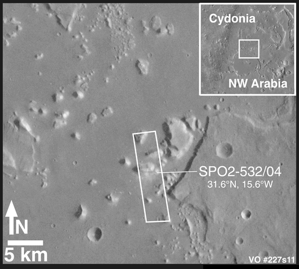
Mars Shoreline Tests: Massifs in the Cydonia Region
MGS MOC Release No. MOC2-182, 1 October 1999
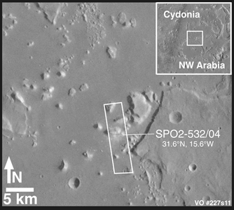 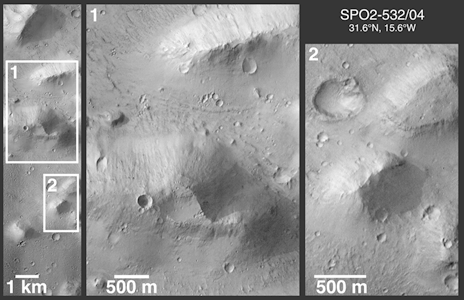
Mars Global Surveyor's (MGS) Mars Orbiter Camera (MOC) took the above picture (second of the two) of some massifs and mesas in the Cydonia region of Mars in early September 1998. The purpose of this image--number SPO2-532/04---was to test the hypothesis that the martian northern plains were once the site of an ocean or large sea. According to this hypthesis, and according to peer-reviewed and published maps, each one of the mesas and massifs in the two pictures above should have shorelines around their margins. The hypothesis holds that these were once islands and that waves would lap--and sometimes crash--against these landforms, rip off huge chuncks of rock, and create steep cliffs and stair-stepped terraces in the rock.
The first picture above shows the regional context of the MOC high resolution view in Cydonia. The context picture, from Viking orbiter image 227S11, is illuminated from the right. The second picture above is a figure that shows the full SPO2-532/04 MOC image and two expanded views of portions of this image. Mesas are flat-topped uplands, and massifs are the more triangular, massive peaks. If an ocean had been present in this region, terraces that indicate erosion or "bathtub rings" of salt or carbonate deposits left by the retreat of this ocean as it dried up might be found around each mesa and massif. No such features are found, nor is it at all obvious why these mesas and massifs were portrayed in previously published figures as having shorelines around them. The MOC image is illuminated from the left.
For a higher-resolution view of the context image (495 Kbyte), CLICK HERE.
For a higher-resolution view of the narrow angle camera figure (890 Kbyte), CLICK HERE.
For additional MOC image tests of proposed martian shorelines, see the following:
Malin Space Science Systems and the California Institute of Technology built the MOC using spare hardware from the Mars Observer mission. MSSS operates the camera from its facilities in San Diego, CA. The Jet Propulsion Laboratory's Mars Surveyor Operations Project operates the Mars Global Surveyor spacecraft with its industrial partner, Lockheed Martin Astronautics, from facilities in Pasadena, CA and Denver, CO.
|
|
|
|
Reply |
Message 4 of 6 on the subject |
|
Cydonia - City on Mars
- An extended review of The Face on Mars -
2009.

|
Viking (spacecraft), first space probe to survive landing on the surface of the planet Mars. Launched by the National Aeronautics and Space Administration (NASA), Viking was the most extensive and complex mission ever to explore Mars and included several experiments designed to test for life on Mars.
The Viking mission used two identical spacecraft to orbit and land on Mars. NASA launched Viking 1 on August 20, 1975, and Viking 2 on September 9, 1975. Each Viking spacecraft consisted of an orbiter, carrying a variety of imaging and remote sensing instruments to study Mars from orbit, and a lander, designed to operate on and intensively study the planet's surface. It took each spacecraft almost a year to reach Mars-Viking 1 went into orbit around Mars on June 19, 1976, and Viking 2 on August 7, 1976. Viking 1 landed on Mars on July 20, 1976, on the western slope of Chryse Planitia. Viking 2 set down September 3, 1976, at Utopia Planitia, 6460 km (4014 mi) from Viking 1.
The Viking spacecraft continued to function long past their planned 90-day mission. The Viking 2 orbiter ran out of fuel for its attitude-control system (the system that keeps the craft's solar panels pointed at the sun) and shut down on July 25, 1978; Viking's controllers on the earth were able to keep the Viking 1 orbiter functioning until August 7, 1980. The last data from the Viking 2 lander were received on the earth on April 11, 1980, and the Viking 1 lander made its final transmission on November 11, 1982.
|
|

The Face on Mars
|
The Cydonia Plateau is home to the famous and controversial "Face on Mars". This mile long, half mile wide and quarter mile high "trick of light and shadow" (NASA) is surrounded by dozens of obviously artificial and mostly pyramid-like structures, all are aligned with the Martian cardinal points and arranged on a proportional grid of one by the square root of two the diagonal of a perfect square and first irrational number.
The entire layout of the complex employs a higher order of mathematics which extrapolates from what was known to the ancients as Sacred Geometry and seems to include the still elusive (to us) Fourth Theorem - a calculus poser involving higher dimensions.
The site also seems to be curiously mirrored (though somewhat reduced in scale, at 14:1) in Avebury (just 30 km north of Stonehenge) with many interesting lignments, among them: When the Spiral Mound on Mars is aligned perfectly with Silbury Hill itself (both are logarithmic spirals), the large crater lines up exactly to The Outer Circle and a road (which predates the area's known history) corresponds perfectly to "the wall" part of "the 10" and southwest, the peak of the five-sided DM Pyramid corresponds to the The Stele.
|
3D Extrapolation of Cydonia
(image by Mark J Carlotto, PhD)
|
 |
 |
 |
 |
Extraplanetary Archaeology - authorities are quick to
dismiss perhaps the most important scientific discovery
in Human history: literal mountains of irrefutable scientific
data, showing that an intelligent, technically sophisticated
and humanoid culture must have once existed on Mars. |
|
|
|
There is a face on Mars. A huge stone, human face: about a mile long, a half mile wide and a quarter mile high. If you believe this, people will laugh at you. But, perhaps the universe is arranged so that something like this is not surprising. If aliens exist, if they've been here, watching us, for millennia, even eons; if Atlantis is real; if the gods of our ancient texts were visitors from other worlds; if humans from planet Earth, or humanoids from other worlds, were exploring this system in ancient times - it takes something like that for something like this to make perfect sense.
If, having vaguely heard of all of these (and other silly stories), and taken them less than seriously (as you're supposed to), you are suddenly struck with this image, presented with the implications: that all that you hold dear, all of the commonly held, society sanctioned beliefs about Man's place in the Universe, and what may or may not be out there - all of this seems suddenly naive, and this frightens you (understandable, it's a bit of a drop). Then, laughter is your only recourse (also sanctioned by society). If you wish to not believe, do not read any further.
There are also pyramids on Mars. At 41° north latitude of our second nearest planetary neighbor, there is an area we modern Earthlings call Cydonia, where exists an elaborate complex of massive and obviously artificial structures - everything about them based on something the ancients called Sacred Geometry.
There's literally mountains of scientific data to back this up; but NASA, government officials, professional skeptics and "mainstream scientists" will (sometimes between flamboyant fits of sensationalism), tell the masses, through the media, how laughably dangerous it is to jump to conclusions about something so mind-bogglingly incredulous as that; and other things which everybody knows are true, and how ridiculous that may just happen to sound. Just thinking along those lines is sadly disrespectful to science, itself.
But make no mistake: there is incontrovertible evidence for the artificiality of the Cydonian structures, long predating any known civilization - on Earth, or anywhere else.
|
The first questions on everyone's mind, are of course, wondering who could possibly have built them - no one knows. If it is the face of a man, or some other humanoid (two eyes, a nose and a mouth), he appears to be wearing a helmet - prehaps even reminiscent of ancient Egyptian headwear. Now we're getting into Ancient Astronaut territory - stop right there, or you're a silly kook. Closer inspection discerns a mouthpiece, gleans a breather - the air is thin on Mars, you know. Aha - they did it - they made it work, despite improbable obstacles and impossible conditions, they built a thriving city of pyramids with Sacred Geometry on the shores of a Martain sea - and then their planet was smashed with an asteroid. Perhaps their detractors were insulted. Imputence.
|
The Sphinx, it turns out, dates back to 10,500 BC (the Age of Leo), right before a minor global cataclysm here on Earth; which is not unlikely to happen, should a major global cataclysm occur on Mars. The Pyramid Complex at Giza is also based on Sacred Geometry, as are many other ancient "sacred" sites worldwide - all of them arranged geometrically to each other on the globe, using the same simple format of basic universal numbers. A search is underway for other artificial sites on Mars - and, using this simple logic, once another is found, we have a pretty good idea where to look for many more.
If you wonder why no one seems to be taking this seriously, that's just the way things are. The way of the world today, at this level in our intellectual and social development, supposedly every foundation of our society would be challenged - our entire way of life: from science and technology to economics, politics and religion. This is huge. This changes everything. Everybody you know will suddenly purport to have believed in UFOs all along. (It's just not polite conversation.) Millions may be found cowering under their beds in the fetal position. And, for millions more, time for war. We're not ready yet. All of the history books would have to be rewritten. "The way things are" would suddenly change overnight. Slowly at first, more in shock than anything else; but soon, certain chaos; definite disaster - and there would be no turning back - or, so goes the reasoning.
Imagine religious institutions' positions, if there were irrefutable evidence that Man was not created on Earth - many would probably insist they still don't believe it; or, that it is the work of the devil. Imagine every nation on Earth, and uncountable internal factions, clamoring for control of every archaeological site they could guess at or half imagine, (or fake: having now become the ultimate commodities, themselves). Governments take over, but they're not equipped to - even military dictatorships will find it impossible to police every ancient monument. And, finally (for some), whoever is able to, will begin seriously searching for Atlantis; trying to find something of the lost rumored super technology - that could, as a species, snap us out of our long amnesia - but it could also snap us, into many pieces.
|
|
Those in power seldom have it in their interest to share it. But they also don't want everything to fall apart, either. Perhaps this is the most important reason why those currently in power so openly and casually dismiss any piece of evidence even remotely along these lines. The first order of business: dismiss any and all facts in evidence; to the point of ridicule, if need be - and next, perhaps even more importantly: discredit the messenger. They don't want anyone else to learn the truth - not just yet anyways: not until they have complete control over the situation. And why stop there?
NASA's official position is that "most scientists" think that the images are an optical illusion - that's what they say. Or, a perhaps wider perception is, that most scientists are afraid to bring forth findings that challenge the establishment - they'd be ruined. The established timeline is dubious, and fulfilled a political need in past centuries for Science to have an easily comprehended answer to many burning questions - but conclusionf for which there was no real hard evidence supporting. If you're a scientist, and you don't believe in evolution, you can't also believe that we're alone in the universe - not and call yourself a scientist; it just doesn't make sense. These conclusions conveniently followed very closely to matters historic and existential, found in western translations of the Bible, and thus were generally accepted as fact without question. It's not just evolution, it's everything.
|
On August 6, 1996 NASA announced Mars Rock ALH84001 (collected from the Alan Hills region of Antarctica, in 1984) was found to have what appears to be fossilized bacteria from millions or perhaps billions of years ago.
|
It is surprising however, that despite the many technological advances in the past century, very few of these suppositions have been openly challenged - despite their now glaring inaccuracies. Debates rage for months, years, even decades - reputations and careers are destroyed - knowledge rots. Gamma-ray bursts turned out to be super-massive black-holes; dark matter, the interstellar medium; Io has volcanoes. When finally an innocent piece of evidence is happened upon, scientists sometimes don't know what to make of it, at first. Too often, the only acceptable conclusion, is that it can't possibly be simply, exactly what it seems. It can't be the obvious first thing you think of, which we were taught to laugh at in school. But then, one rogue comes along, perhaps with the job security to point out the obvious - and everyone's happy again, almost; for a time. For probably every stunning scientific discovery, there's a discredited scientist somewhere, who submitted a paper ages ago, hypothesizing same; and was deemed misguided - a kook.
In the scope of history, Science seems to be making an incremental ascension to the truth, as each new revelation eventually becomes politically convenient. In the Renaissance, Galileo's telescope ultimately helped prove earlier "heretic" theories that the Earth orbits the Sun, and not the other way around. The People of the day were ready for this, but the Church was not - neither was the Church ready for the People to know the Truth. After all, if they were seen to have been so wrong for so long about something like that, everything else may have come into question - but, most importantly, their authority. Today, Earth is being gradually downgraded: slowly accepted as being no longer unique in its ability to support life - but these are still grudging admissions. Every day, the scientist who stands firm in his belief of life on other worlds, becomes more and more accepted by his colleagues in more mainstream science - but there is still a long way to go. Yes, Virginia: the Face on Mars, too.
Among the most intriguing and most ridiculed of curiosities supporting the artificiality of the Cydonia Complex is that all of these objects are precisely arranged using the same universal mathematics and Sacred Geometry that are found in all of the most impressive and most ancient of archaeological sites here on Earth - where there also just happen to be giant pyramids, occasionally; another sacred geometrical form - but nothing even approaching the scale and scope of those found on Mars.
Today, thanks to the Mars Rock ALH84001 and recent robotic missions, it is widely accepted that there was once water, and even a breathable atmosphere on Mars. But whatever global cataclysm that made the Red Planet now completely inhospitable to Human life, these massive monuments remain in stony testimony to a once thriving perhaps even Human civilization, present on Mars so long ago - who were apparently far more technologically advanced than we are today - unless they were just poets at math, and shuttled interplanetarily by someone else. Possibly Earthlings: maybe humanoid life originated on Mars first, and we're its descendants. This is not science fiction. This is science fact. It may take the world a while to warm up to the idea.
|
Whoever it is up there, depicted for everlasting posterity, it was designed to be appreciated from above - and at a mile and a half across, over half a mile wide and a quarter mile high - one wonders if the denizens of this ancient coastal region ever considered themselves a planetbound society. Were they visitors, colonists from another star system; or is this just the only remnant we have of an ancient humanoid civilization on Mars?
Maybe it was pure artistic expression, or even simple vanity, like the kind of statues we have virtually everywhere in our own modern cities today. One thing is certain, it stands out like a sore thumb - you can't miss the site. Intentional or not, meant for themselves or distant descendants (namely, us): this is exactly what one would expect to find if our society were to hold the belief that there has ever been beings like ourselves beyond our sphere.
In any case, even if there were no Face, the design and layout of the complex surrounding: this is the trademark mysterious way that the ancients did things - yet, "mainstream" science appears to be refusing to even look into it. As far as they're concerned, there is nothing to it; and anyone who thinks there is, should not be taken seriously. But some researchers have discovered that authorities are in fact taking this very seriously, indeed. But it's a members-only club; and those who would speak this shocking truth aloud, for anyone to hear, need not apply themselves.
|
High-resolution images of the Face, made from NASA's original 1998 MGS widely publicized "debunking" press-release image (below); which is suspected to have been altered in favor of ambiguity.
The lighting is from the east (morning sun), perhaps naturally obscuring detail: of obvious, evident, equidistant, parallel, artificial symmetry in the surrounding platform; especially in the straight eastern and curved north edges. But, even the "raw" image clearly shows the straight western and curverd southern edges: so the public can see where even a conscientious scientist might easily make the mistake.
|
|
|
|
|
Mars orange false-color
added here for contrast |
same image inverted to simulate
lighting from the northwest |
rotated 180° (upside down)
reminding us of its symmetry |
|
|
|
|
|
Reply |
Message 5 of 6 on the subject |
|
The Viking Photos
The Overlooked Images
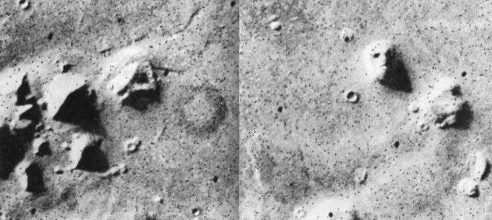
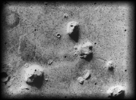
In 1976, Viking 1 was the much anticipated next logical step after the Mercury and Apollo missions. On this groundbreaking survey, the primitive probe/spacecraft took many thousands of pictures red planet's features and sent them back to NASA. On July 25th, Tobias Owen of JPL was going over the data from Viking 1, for possible landing sites for Viking 2, when he came across a glimpse of history. "Oh my god, look at this! That looks like a face!" he said, as he examined frame 35A72 (below), a solitary structure reminiscent of the Sphinx, staring serenely out into space.
In a press conference later that same day, Viking project spokesman Gerry Soffen coined the famous phrase "trick of light and shadow" - and claimed that just a few hours later, the image no longer appeared to be a face - casually dismissing perhaps one of the greatest discoveries of all time. This was, in fact, a lie - there were no pictures taken of Cydonia a few hours later, as night had fallen on that side of the rusty planet. Any "later" photograph proving that the mound in no way resembled a human face was not to be forthcoming - and if any other Cydonian images were ever shot, the matter was not discussed openly. There were to be no further images released to the public until Mars Global Surveyor - on May 5, 1998.
|
JPL Press release on The Face on Mars - July 31, 1976 - from Viking 1 frame 35A72
|
JPL Press release on The Face on Mars - July 31, 1976
"This picture is one of many taken in the northern latitudes of Mars by the Viking 1 orbiter in search of a landing site for Viking 2. The picture shows eroded mesa-like landforms. The huge rock formation in the center, which resembles a human head, is formed by shadows giving the illusions of eyes, nose, and a mouth. The feature is 1.5 kilometers (1 mile) across, with the sun angle at approximately 20 degrees. The speckeld appearance of the image is due to bit errors, emphasized by enlargement of the photo. The picture was taken on July 25 from a range of 1,873 kilometers (1,162 miles). Viking 2 will arrive in Mars orbit next Saturday [August 7] with a landing scheduled for early September. "
In the above caption, replace the possibly intentionally misleading NASA words "shadows" with "fissures" or "indentations" - and "illusions" with "appearance." Cydonia investigators believe that this press release was censored at the last minute and that the original statement reflected the scientists true feelings of astonishment and cautious celebration, regarding the surprising discovery on the first close-up photos of Mars. Imagine how many more telling sentences might have been omitted from this announcement regarding the first images from another planet, that just happen to reveal not one, but several, possibly man made monuments - and suddenly the whole Cydonian issue is taken more seriously.
|
|
From: The Case for the Face - by McDaniel, Paxon, et al - p. 69
The next development was a decision from NASA that Viking 2 would not, after all, land at Cydonia. Apparently the site was now deemed "unsafe." According to Carl Sagan:
44 degrees north was completely inaccessible to radar site-certification; we had to accept a significant risk of failure with Viking 2 if it was committed to high northern latitudes. . . . To improve the Viking options, additional landing sites, geologically very different from Chryse and Cydonia, were selected in the radar-certified region near 4 degrees south latitude.
All this notwithstanding, it is an extraordinary fact that Viking 2 was finally set down at a latitude even higher than Cydonia. It landed - and was almost overturned by boulders - on the distinctly unpromising rock-strewn plain called Utopia, at 47.7 degrees north latitude, on 3 September 1976. Thus - for no obvious reason says James Hurtak - "a multimillion dollar effort may have overlooked 'paydirt' and may have become a trivial event. . . . A poor selective factor had been used to choose an area of minor geological and biological significance. It was like choosing the Sahara Desert as a suitable landing site on our own planet."
|
Cydonia - Viking 1 frame 35A72
|
|
NASA Viking 1 Frame 35A72 - from the 1979 German book Wir, vom Mars by Walter Hain
The many dots in the image above is "salt and pepper" or "bit errors" or missing-data static
Viking 1 Landing Site
Viking 1 landed at Chryse Planitia on July 20, 1976
just north of Valles Marineris
|
Spin Control
The whole issue of Cydonia as a possible landing site was dropped as soon as the pictures became public. This is quite surprising considering that it was a far better and more interesting candidate than Utopia (where Viking 2 ultimately landed), According to Carl Sagan: "there was a significant chance of small quantities of liquid water there." There can be only one reason for the sudden dismissal: they didn't want anyone to know about the strange monuments found there. Any proof of anything beyond what is considered to be accepted human history would be controversial in the extreme. But is it possible that Cydonia was not left alone, but actually highly classified at the highest levels? And what could already seem more ridiculous, more easily dismissed, by serious "respectable" science? To quote the movie Contact, ironically written by Carl Sagan, "first rule of government spending: why have only one, when you can have two at twice the price?" How many missions could there possibly be that the public at large knows nothing about? And how many of the supposedly malfunctioned spacecraft, are actually alive and well?
The only way that "we the people" would have gotten anything anywhere near full disclosure from the Mars missions would have been if all of NASA's wildest hopes and dreams had come amazingly true - that Mars was, as previous data had suggested, capable of supporting life as we understood it in the 1960s and 70s. If Mars had moss or algae, or even insects - big business would have been instantly involved and there would certainly be people there by now. Imagine, another tiny island to be conquered - completely isolated from outside interference and no pesky indeginous inhabitants to lay claim to the wealth of resources to be found on an entire planet - not to mention the strategic military and political values. Perhaps science and civilization have been given a back seat to these interests.
Ever since man began sending missions to Mars, nearly all of them have mysteriously failed. It seems that if they manage to make it into space at all, they break down somehow, or all contact is lost, or they crash onto the surface of the planet, never to be heard from again - sometimes under such mysterious circumstances as to raise the eyebrows of ufologists. One perhaps intentional effect of all this staggering disappointment is that the public at large, though perhaps at first intensely curious about the red planet, ultimately has no idea of the controversial reality. Many suspect that this was far too convenient to be true, as it only served to decrease attention and increase the distance between the public and that arm of the space program - and if there really are monuments on Mars, the powers that be have no intention of sharing that information with the general public. It is also especially highly likely that what can be found out on the subject is only the smallest fraction and most easily dismissable aspect of the entire story. Who knows - perhaps, as ufologists suggest, there really is sentient life on Mars, occasionally shooting down whatever probes of ours they can.
|
Mars Global Surveyor - Mars Orbiter Camera
Malin Space Science Systems and the California Institute of Technology built the MOC using spare hardware from the Mars Observer mission. MSSS operates the camera from its facilities in San Diego, CA. The Jet Propulsion Laboratory's Mars Surveyor Operations Project operates the Mars Global Surveyor spacecraft with its industrial partner, Lockheed Martin Astronautics, from facilities in Pasadena, CA and Denver, CO.
An attempt to take a picture of a portion of the "Face" itself (M12-01787) in mid-February 2000 was foiled when the MGS spacecraft experienced a sequencing error and most of that day's data were not returned to Earth. Only the first 97 lines of M12-01787 were received....
The MGS spacecraft had a sequencing error on February 17, 2000, which resulted in a loss of most of the data collected by the spacecraft's instruments that day. The anomaly is described below in the MGS Status Report from the Jet Propulsion Laboratory. Status reports from MGS are generated weekly and can be found at » NASA Marsweb.
Here is the content of the MGS Status Report that described the February 17, 2000, events:
Wednesday, February 23, 2000
(DOY 047/19:00:00 to DOY 0454/19:00:00 UTC)
Launch - Nov 7, 1996
Days since Launch - 1206 days
Start of Mapping - April 1, 1999
Days since Start of Mapping - 328 days
Total Orbits = 5987
Total Mapping Orbits = 4305
Recent Events:
The pace of the new mapping Beta sequence generation problem, a build every week, and a realization of new operational constraints imposed by the new mapping scheme, has caused two sequencing errors over the last week.
On 00-048 (2/17/2000) at about 00:00 UTC, the new Beta Supplement sequence, mm014b, was scheduled to kickoff but never went active. Since that new sequence controls the tracking of the HGA to Earth, no downlink was possible. Using a 34-m HEF station, a command was successfully uplinked via LGR-2 to change the uplink rate from 125 bps to 7.8 bps. Then, at 7.8 bps, a mini-sequence was successfully radiated to auto-track the HGA for about 30 minutes per orbit for 4 consecutive orbits, allowing for a 4K real-time downlink. During the first of these orbits, spacecraft telemetry was obtained which showed that MGS was in a healthy condition. During the second of these orbits, the uplink rate was changed back to 125 bps and the new mm014c sequence was uplinked to resume normal operations. The mm014c sequence began execution nominally at 14:20 UTC and has successfully completed execution. The mm015 sequence, was uplinked and began execution on 00-051 (2/20/2000) at 00:00 UTC. The mm015 sequence is scheduled to run through 00-054 (2/23/2000). The net effect of the anomaly was the loss of most of DOY 48 recorded science telemetry.
The cause of the mm014 sequence anomaly was that it was loaded into the incorrect area of the sequence buffer, which was already executing the mm013 sequence. This error was induced by having to split the 7 day beta supplement sequence into two parts due to the size of the sequence and the much reduced uplink time available each orbit due to the complex HGA management. This splitting process introduced an ambiguity in the naming convention: mm013a was used for Part 1 of sequence 013 rather than revision level a, and mm013b was used for Part 2 of sequence 013 rather than revision level b. When a second revision of Part 1 was required, mm013c was used, since mm013b was already taken by Part 2. Due to the ambiguity in the naming convention, mm014 was run through SEQTRAN using the FINCON file from mm013c (Part 1) rather than mm013b (Part 2). The result was that mm014b was loaded into the same buffer area as Part 2 of the previous sequence. Since this previous sequence was still executing when mm014b was uplinked, the new sequence did not go active.
To confound matters, due to the current MGS to Earth range, we are not able to support two-way data (uplink and downlink data) at the high rate 40 ksps real-time downlink rate. Therefore all uplinks are currently performed during orbits in which the recorded data from the previous day is being played back. Therefore confirmation of a successful sequence uplink and activation requires waiting until the next day's data is played back. For this case there was insufficient time available to determine that the sequence load had been rejected and to rebuild a replacement sequence in time. This was due in part to a half-day loss in the schedule due to a problem with our spacecraft test lab (STL).
The second anomaly occurred with the development of the mm016a sequence, which was uplinked successfully to the spacecraft on 00-052 (2/21/200) and scheduled to begin execution on 00-055 (2/24/00) at 00:00 UTC. In this event an error in the recording and playback of the science data was discovered after the sequence had been uplinked. The sequence was successfully terminated on 00-054 (2/23/2000) at ~14:00 UTC and a replacement sequence, mm016b, uplinked several orbits afterwards upon confirmation of the termination of mm016a. The root cause for this anomaly was simply a rush to uplink the sequence early enough to verify its activation in order to avoid a repeat of the mm014 sequence anomaly.
Several changes have been made to the sequence development process for the weekly sequence builds. The first change, which was already going to be made for the next sequence anyhow, was to rename the sequences. The split of the weekly sequences into two parts creates two sequences, mm016 and mm017, for example, rather than mm016a and mm016b. The second and probably the most important change made was to increase the sequence development time by three days to provide sufficient time with margin for development, review, STL validation, uplink and verification of the sequences.
One final note, the failure to get a new sequence on-board the spacecraft poses no risk to the health of the spacecraft. The spacecraft will maintain mapping nadir pointing and articulation of the solar array. Communications from the spacecraft and collection of science data will be interrupted until a new sequence can be uplinked.
Spacecraft Health:
All subsystems are reporting nominal health. A sixth PDS reset occurred on 00-019. So far no cause has been found for the recurring resets. The resets appear to have minimal if any impacts to the instruments. We continue to forward all reset data to the PDS software experts at JPL.
Uplinks:
There have been 14 uplinks to the spacecraft during the last week, including new star catalogs and ephemeris files, instrument command loads, and the mm014, mm015 and mm016 sequences. Total command files radiated to the spacecraft since launch is 4459.
Upcoming Events:
The first fixed-HGA mapping sequence of the beta supplement era is scheduled for March 6 and development of this sequence has begun. One of the limitations of the mapping beta supplement scheme is a loss of South Pole radio science atmospheric data due to HGA gimbal constraints. The project approved a three to four day period each month to perform fixed-HGA operations, in which the HGA is pointed along the spacecraft +X axis and the spacecraft is moved to point the HGA to Earth for an eight-hour period (i.e. four orbits). During the eight-hour Earth pointed period the science data recorded from the previous 24 hours of nadir pointed mapping is played back. This scheme allow radio science observations to be made at Earth occultation ingress and egress, at the expense of collecting mapping data for the eight-hour Earth pointed period. The project also approved monthly MOLA nadir off-pointed polar observations. These observations will be performed during the 24 hour nadir pointing period prior to the first eight-hour fixed-HGA Earth pointed period.
Mars Surveyor Operations Program - Mars Global Surveyor
Cydonia: Two Years Later
MGS MOC Release No. MOC2-222, 5 April 2000
FIGURE 1: Viking Orbiter mosaic showing landforms in Cydonia with popular, informal names.
The recent motion picture, "Mission to Mars," takes as part of its premise that certain features in the Cydonia region of Mars were constructed as monuments by ancient Martians. This idea - widely popularized in books, magazines, tabloids and other news/infotainment media - has its origin in the chance observation (in 1976) by one of the Viking Orbiter spacecraft of a » face-like hill. The "face" and other nearby landforms are labeled in the above mosaic of Viking Orbiter images from the 1970s.
On April 5, 1998, the Mars Global Surveyor (MGS) spacecraft performed a specially-planned maneuver to photograph the "Face on Mars." Having successfully » imaged the "Face" on its first attempt, two additional maneuvers were used to observe other purported "artifical" features: » the "City" (a cluster of small mountains west-southwest of the "Face") and » the "City Square" (a group of four small hills surrounded by the larger mountains of the "City"). These special observations occurred during the Science Phasing Orbits period of the MGS mission, while the spacecraft was in a 12 hour, elliptical orbit. A year later, in March 1999, MGS attained its final, circular, polar Mapping Orbit, from which it has now subsequently observed the planet for a year. During this year of mapping, the Mars Orbiter Camera (MOC) has continued to make observations within the Cydonia region whenever the MGS spacecraft has flown over that area.
Narrow Angle Camera Views of Cydonia
FIGURE 2: Location of MOC images acquired during the past two years, April 1998 to April 2000. Click on ID numbers to browse
the images. These are presented at 40% size with north approximately "up". For full-resolution images, see list below.
The above figure shows the location of all high resolution (narrow angle) MOC images of the Cydonia region that have been obtained to date, including the first three taken in 1998. Images acquired during the Science Phasing Orbit period of 1998 slant from bottom left to top right; Mapping Phase images (from 1999 and 2000) slant from lower right to upper left. Owing to the nature of the orbit, and in particular to the limitations on controlling the location of the orbit, the longitudinal distribution of images (left/right in the images above) is distinctly non-uniform. An attempt to take a picture of a portion of the "Face" itself (M12-01787) in mid-February 2000 was foiled when the MGS spacecraft experienced a » sequencing error and most of that day's data were not returned to Earth. Only the first 97 lines of M12-01787 were received; the image's planned footprint is shown as a dashed box.
Wide Angle Camera Views of Cydonia
Although the resolution of the MOC wide angle cameras is too low to tell much about the geomorphology of the Cydonia region, the images from the red and blue wide angle cameras provide us with two types of information that is of interest in their own right: color and stereoscopic data. Above are a color view and a stereoscopic anaglyph rendition of Geodesy Campaign images acquired by MGS MOC in May 1999. To view the stereo image, you need red/blue "3-d" glasses.
Many apparently artificial, geometrical features are evident in the lower, southern half of the wider angle image (above left). Starting in the middle (just south of The City, and what might have been a natural bay developed into a harbor): a 120° angle, straight edged dropoff and a rougher but mirrored rise to the south, form a parallelogram mesa, approximately 10 miles wide, edge to edge, that was perhaps once a Waterfront Plaza (just west of what appears to be a new crater). And, southwest of that, an almost tetraheydral looking feature that could possibly be an additional pyramidial strusture (compare to the D&M Pyramid, lower center, right image). In the lower quarter, two parallel slash marks, over a mile apart (like an equals sign) forming a kind of avenue between them; each about three miles long and a quarter to half-mile wide. Just below that, a very natural looking bay, with an inlet off to the east; and, to the south of that, very natural looking "foothills" with assorted curious straight-edged and slightly rounded features which may prove to be artificial upon further analysis.
Additional Information and Views
40% Views Accessed Via Figure 2:
Each of the high resolution, or narrow angle, views of the Cydonia region that can be accessed by clicking on the ID numbers in Figure 2 has been processed to remove the vertical striping that is caused by the non-uniform sensitivity of the MOC narrow angle camera; rotated so that north is approximately "up" and east is toward the right; linearly-stretched to show details/contrast, and reduced to 40% of its original size so that it can be viewed with most web-browsing software. Non-unity aspect ratios have not been corrected in these views.
Full-Resolution Views Accessed by ID Numbers Below:
The full-resolution views of each Cydonia image are provided in the list below. Each has been processed to remove the vertical striping that is caused by the non-uniform sensitivity of the MOC narrow angle camera. No additional processing has been applied. In particular, these images are usually not oriented with north to the top. Many also have aspect ratios greater than 1 (this means that craters will look "squished"). For those who want detailed information on these images that can be used to process them further, an » ancillary data table is provided. Some of the full-resolution images are too large to be viewed in your web-browser; the "save this link as" option should be used to download the image to your desktop, then open it with your favorite image viewing or image processing software. All pictures are in GIF format.
Several Large views of Figure 2 without labels:
All Images Please Credit: NASA/JPL/Malin Space Science Systems
|
|
|
|
Reply |
Message 6 of 6 on the subject |
|
There were more clues, of course, including:
- Bruno Mars and Red Hot Chili Peppers doing the halftime show
- One of the teams was the Denver Broncos from "Colorado" which means "color red"
- Though technically in New Jersey, the Super Bowl was essentially in New York City (MetLife Stadium), or the "Big Apple"... as in the Golden Apple (MetLife Stadium is the home of both the New York Giants and New York Jets); "Golden Apple" is synonymous with "Cydonia"
- NYC/MetLife Stadium is at latitude ~40.8°N, exactly the same latitude as the "Monuments"of Cydonia on Mars including the "Face on Mars"
The "Golden Apple" allusion represents a time arrow pointing ahead to the "Golden Apple Alignment" in mid October right before Martian (almost) Deep Impact day.
[NOTE: Orange/Golden Apple Alignments are typically (but not always) time markers for major "earth changes" events such as earthquakes, as well as papal events, etc. And it's been my observation after nearly a decade of closely tracking these alignments that when Earth joins an Orange Alignment, the energy is amplified. That's what we'll have with the upcoming Orange/Golden Apple Alignment (mid Oct 2014).]
The Cydonia/Face on Mars allusion is even more revealing... starting with the fact that the Face can transform into a (reverse) sphinx, with a lion head and a human (pregnant) body:

In the sky, the Great Sphinx has a counterpart in the form of the constellation Leo. And there was a remarkable "omen" there earlier this year, right on the vernal/March equinox (March 20)... or the exact day the gaze of the Great Sphinx aligned with sunrise.
|
|
|
First
Previous
2 a 6 de 6
Next
Last
|
|
| |
|
|
©2025 - Gabitos - All rights reserved | |
|
|