German Village is a historic neighborhood in Columbus, Ohio, just south of the city's downtown. It was settled in the early-to-mid-19th century by a large number of German immigrants, who at one time comprised as much as a third of the city's entire population. It became a city historic district in 1960[2] and was added to the National Register of Historic Places in 1974, becoming the list's largest privately funded preservation district,[3] and in 2007, was made a Preserve America Community by the federal government. In 1980, its boundaries increased, and today it is one of the world's premier historic restorations.
In 1796, Congress appropriated the Refugee Lands for Canadian province individuals who had supported the Colonial cause in the American Revolution. By 1802, an American Revolution veteran named John McGowan claimed 328 acres (1.33 km2), most of what would become the German Village. As German immigrants arrived, McGowan sold tracts of land to them. By 1814, a settlement had grown up, originally called "Das Alte Südende" (the Old South End), and German immigrants contributed to building the first statehouse.
By 1830, massive German immigration to the city had occurred. The most influential German newspaper in 1843 was Der Westbote. Many would serve in the American Civil War, thus gaining the universal respect of the local citizens. By 1865, one-third of Columbus's population was German and the community was flourishing. They built up the local neighborhood, including many businesses, such as Hessenauer Jewelers and Lazarus Department Stores, schools, and churches, such as the Ohio-historic St. Mary's Catholic Church, built in 1865 and adorned with a 197-foot (60 m) steeple in 1893.[4] German-American George J. Karb became mayor of the city, twice, at the end of the 19th century and again in the early 20th century.[5]
During the early 20th century, the south end saw newcomers from eastern Europe aside from German immigrants, resulting in brother neighborhoods such as the Hungarian Village.[6]
The local schools the German immigrants constructed and managed were so superior that English-speaking residents of Columbus chose to attend them, such as one that once stood at Fulton Street east of S. Fourth Street.[5][7]
Capt. Eddie Rickenbacker, a World War I hero from the Columbus German-American community
The area was in serious decline throughout the first half of the 20th century, partly due to anti-German sentiment during World War I. During that time, the teaching of German in public schools was banned and German textbooks were burned. German street names were changed, such as Germania Street becoming the present-day Stewart Avenue,[8] and Schiller Park was temporarily renamed Washington Park. The anti-German sentiment fueled by the media was so bad that in 1918, German books were burned on Broad Street and at the foot of the Schiller statue. German canine breeds were taken from their owners and slaughtered, including German Shepherds and Dachshunds. Despite the hatred, the Columbus German American community would produce one of America's finest heroes from the war, Captain Eddie Rickenbacker, for whom Rickenbacker International Airport in southern Columbus is named.
Further decline occurred later due to the closing of the local breweries during Prohibition. After the war, the south end was zoned for manufacturing, leading to the erosion of the area's residential feel. In World War II, the streetcar tracks and wrought-iron fences were confiscated for the war effort. By the 1950s, the area had become a slum and the city decided to demolish one-third of the neighborhood.[9][10]
With the Village nearing complete destruction, Frank Fetch defied the common wisdom and purchased a house on S. Wall Street, determined to rebuild the neighborhood. Fetch would create the German Village Society. In June 1960, the society hosted the first Haus und Garten Tour, which attracted visitors and the local media to eight restored homes and two gardens. Today, the tour is one of the city's most popular events.[11] Frank Fetch Park was named after him.
Concerned citizens managed to save its historic architecture from demolition in the 1960s by lobbying for a local commission, the German Village Commission, to have power over external changes made to buildings and by getting the area listed on the National Register of Historic Places in 1975.[11] As of 2009, the German Village Society has over 1,000 preservationists who maintain the historic quality of the buildings and neighborhood, and German Village is considered one of the most desirable areas to live in the city.[12] More than 1,600 buildings have been restored since 1960 and it is credited as one of the world's premiere restoration districts.[13] By the 1980s, the restoration was nearly complete. Today, it is the largest privately funded historic district on the National Register of Historic Places.[3]
German tradition has long reigned in the community in the form of an annual Oktoberfest festival. It originally took place in Schiller Park and has been held at various locations within the German Village neighborhood. Due to new development in the area, it now takes place at the Ohio State Fairgrounds / Ohio Expo Center. The festival was voted to be canceled in 2009, but the Schmidt (owners and operators of Schmidt's Sausage Haus) and Cox families stepped in to keep it running.[17] A smaller Oktoberfest still goes on in the German Village itself, at the Germania Gesang und Sport Verein (Singing and Sports Club) at 543 South Front Street in the old Schlee Brewmaster's House and outdoor garden.[18]
Although German Village is an eclectic community, the area is known as a residential gay village. While there are no gay establishments within German Village, the neighboring Brewery District and Merion Village have several.
Much of the area in present-day south downtown along I-70 was at one point considered part of German Village, including the Market Exchange District, which has experienced a revival alongside German Village.[19]
German Village is bound by Pearl Street on the west; East Livingston Avenue on the north; Lathrop Street, Brust Street, Grant Avenue, Jaeger Street, and Blackberry Alley on the east; and Nursery Lane on the south. [20]
Schiller Park, named after Johann Christoph Friedrich von Schiller (1759-1805), was once a community meeting ground for German immigrants. It is now the site of recreational facilities, gardens, and an amphitheater that hosts free live performances of Shakespearean plays during the summer months courtesy of Actors' Theatre of Columbus.[21] It is bounded by Jaeger Street and City Park, Reinhard, and Deshler Avenues. It has been the area's center for festivals and neighborhood activities since the 1800s.
The 23-acre park's main entrance, along City Park Avenue, greets visitors with the Huntington Gardens, sponsored by Huntington National Bank and maintained by volunteers, and the Schiller statue. The statue was presented to the park by local residents in 1891. It is a second casting of the statue in Munich, Germany, designed and executed by Max von Widnmann and unveiled on May 9, 1863. The Columbus statue was transported free of charge across the Atlantic. The park is also home to Umbrella Girl, dedicated to the citizens of German Village in October 1996 to replace the missing original sculpture.
The neighborhood's Stewart Alternative Elementary School, was built in 1874. It is one of the oldest remaining school buildings in Columbus, built at the same time as the First and Second Avenue Schools, also still extant.[22]
The Jordan River, in the state of Utah, United States, is a river about 51 miles (82 km) long. Regulated by pumps at its headwaters at Utah Lake, it flows northward through the Salt Lake Valley and empties into the Great Salt Lake. Four of Utah's six largest cities border the river: Salt Lake City, West Valley City, West Jordan, and Sandy. More than a million people live in the Jordan Subbasin, part of the Jordan River watershed that lies within Salt Lake and Utah counties. During the Pleistocene, the area was part of Lake Bonneville.
Members of the Desert Archaic Culture were the earliest known inhabitants of the region; an archaeological site found along the river dates back 3,000 years. Mormon pioneers led by Brigham Young were the first European American settlers, arriving in July 1847 and establishing farms and settlements along the river and its tributaries. The growing population, needing water for drinking, irrigation, and industrial use in an arid climate, dug ditches and canals, built dams, and installed pumps to create a highly regulated river.
Although the Jordan was originally a cold-water fishery with 13 native species, including Bonneville cutthroat trout, it has become a warm-water fishery where the common carp is most abundant. It was heavily polluted for many years by raw sewage, agricultural runoff, and mining wastes. In the 1960s, sewage treatment removed many pollutants. In the 21st century, pollution is further limited by the Clean Water Act, and, in some cases, the Superfund program. Once the home of bighorn sheep and beaver, the contemporary river is frequented by raccoons, red foxes, and domestic pets. It is an important avian resource, as are the Great Salt Lake and Utah Lake, visited by more than 200 bird species.
The Jordan River is Utah Lake's only outflow. It originates at the northern end of the lake between the cities of Lehi and Saratoga Springs. It then meanders north through the north end of Utah Valley for approximately 8 miles (13 km) until it passes through a gorge in the Traverse Mountains, known as the Jordan Narrows. The Utah National Guard base at Camp Williams lies on the western side of the river through much of the Jordan Narrows.[7][8] The Turner Dam, located 41.8 miles (67.3 km) from the river's mouth (or at river mile 41.8) and within the boundaries of the Jordan Narrows, is the first of two dams of the Jordan River. Turner Dam diverts the water to the right or easterly into the East Jordan Canal and to the left or westerly toward the Utah and Salt Lake Canal. Two pumping stations situated next to Turner Dam divert water to the west into the Provo Reservoir Canal, Utah Lake Distribution Canal, and Jacob-Welby Canal. The Provo Reservoir Canal runs north through Salt Lake County, Jacob-Welby runs south through Utah County. The Utah Lake Distribution Canal runs both north and south, eventually leading back into Utah Lake.[9] Outside the narrows, the river reaches the second dam, known as Joint Dam, which is 39.9 miles (64.2 km) from the river's mouth. Joint Dam diverts water to the east for the Jordan and Salt Lake City Canal and to the west for the South Jordan Canal.[10][11][12]
Map of the Salt Lake Valley
The river then flows through the middle of the Salt Lake Valley, initially moving through the city of Bluffdale and then forming the border between the cities of Riverton and Draper.[7] The river then enters the city of South Jordan where it merges with Midas Creek from the west. Upon leaving South Jordan, the river forms the border between the cities of West Jordan on the west and Sandy and Midvale on the east. From the west, Bingham Creek enters West Jordan. Dry Creek, an eastern tributary, combines with the main river in Sandy. The river then forms the border between the cities of Taylorsville and West Valley City on the west and Murray and South Salt Lake on the east. The river flows underneath Interstate 215 in Murray. Little and Big Cottonwood Creeks enter from the east in Murray, 21.7 miles (34.9 km) and 20.6 miles (33.2 km) from the mouth respectively. Mill Creek enters on the east in South Salt Lake, 17.3 miles (27.8 km) from the mouth. The river runs through the middle of Salt Lake City, where the river travels underneath Interstate 80 a mile west of downtown Salt Lake City and again underneath Interstate 215 in the northern portion of Salt Lake City. Interstate 15 parallels the river's eastern flank throughout Salt Lake County. At 16 miles (26 km) from the mouth, the river enters the Surplus Canal channel. The Jordan River physically diverts from the Surplus Canal through four gates and heads north with the Surplus Canal heading northwest. Parley's, Emigration, and Red Butte Creeks converge from the east through an underground pipe, 14.2 miles (22.9 km) from the mouth.[7] City Creek also enters via an underground pipe, 11.5 miles (18.5 km) from the river's mouth. The length of the river and the elevation of its mouth varies year to year depending on the fluctuations of the Great Salt Lake caused by weather conditions. The lake has an average elevation of 4,200 feet (1,300 m) which can deviate by 10 feet (3.0 m).[3] The Jordan River then continues for 9 to 12 miles (14 to 19 km) with Salt Lake County on the west and North Salt Lake and Davis County on the east until it empties into the Great Salt Lake.[7][8][11]
The United States Geological Survey maintains a stream gauge in Salt Lake City that shows annual runoff from the period 1980–2003 is just over 150,000 acre-feet (190,000,000 m3) per year or 100 percent of the total 800,000 acre-feet (990,000,000 m3) of water entering the Jordan River from all sources. The Surplus Canal carries almost 60 percent of the water into the Great Salt Lake, with various irrigation canals responsible for the rest. The amount of water entering the Jordan River from Utah Lake is just over 400,000 acre-feet (490,000,000 m3) per year. Inflow from the 11 largest streams feeding the Jordan River, sewage treatment plants, and groundwater each account for approximately 15 percent of water entering the river.[13]
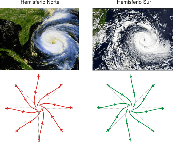
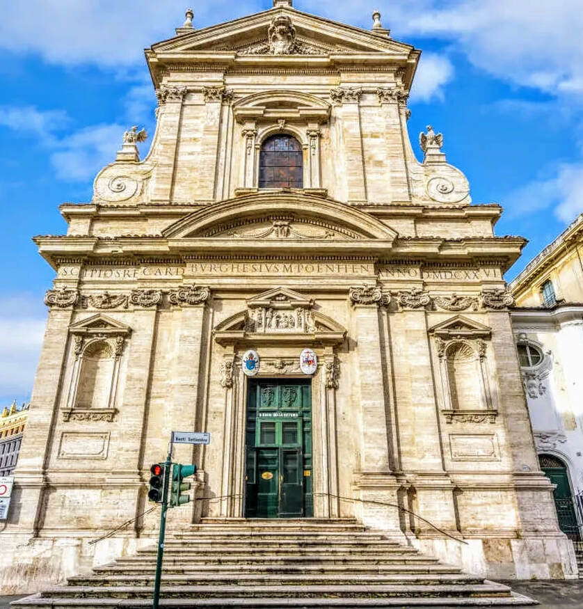
Los Carmelitas descalzos obtuvieron un Breve apostólico de Paulo V para edificar conventos de su Orden en cualquier parte de la Cristiandad; fue este el primero que fundaron en la última parte del Monte Quirinal el año de 1606.
La iglesia se fundó en 1605 como una capilla dedicada a san Pablo para los carmelitas descalzos. La propia orden dotó de fondos a la obra del edificio hasta el descubrimiento en las excavaciones de la escultura conocida como el Hermafrodita Borghese. Scipione Borghese se apropió de ella, pero a cambio, y quizá para compensar su pérdida de influencia debido a la muerte de su tío y patrón, financió el resto de la obra de la fachada y prestó a la orden a su arquitecto, Giovanni Battista Soria. Estas concesiones, sin embargo, sólo se llevaron a efecto en 1624, aunque la obra se acabó dos años más tarde.
Después de la victoria católica en la batalla de la Montaña Blanca en 1620, que hizo retroceder la Reforma en Bohemia, la iglesia fue consagrada de nuevo a la Virgen María. Una imagen maltrecha había sido recuperada del ámbito de aquella batalla por Fray Domingo de Jesús María, de dicha Orden, de las ruinas de la casa de campo de un noble cristiano bohemio, a la cual se le atribuyó la victoria, llamándola Santa María de la Victoria. La imagen fue llevada a Roma por Fray Domingo, depositándose en Santa María la Mayor en presencia de Gregorio XV.
El nombre de Santa María de la Victoria, se dio ulteriormente, en conmemoración por haber reconquistado el emperador Fernando I la ciudad de Praga en 1671. Estandartes turcos capturados en el Sitio de Viena de 1683 cuelgan en la iglesia, como parte de este tema victorioso.
La iglesia es la única estructura diseñada y completada por el arquitecto del Barroco temprano, Carlo Maderno, aunque el interior padeció un fuego en 1833 y requirió una restauración. Su fachada, sin embargo, fue erigida por Soria en vida de Maderno (1624-1626), mostrando la inconfundible influencia de la cercana Santa Susanna de Maderno.
Su interior tiene una sola nave, amplia, bajo una bóveda segmentada baja, con tres capillas laterales interconectadas detrás de arcos separados por colosales pilastras corintias con capiteles dorados que apoyan un rico entablamento. Revestimientos de mármol que contrastan entre sí están enriquecidos con ángeles y putti de estuco blanco y dorado en bulto redondo. El interior fue enriquecido progresivamente después de la muerte de Maderno; su bóveda fue pintada al fresco en 1663 con temas triunfales dentro de compartimentos con marcos ficticios: La Virgen María triunfa sobre la Herejía y Caída de los ángeles rebeldes ejecutados por Giovanni Domenico Cerrini.
Sin duda, parte de la fama de este templo se debe a albergar una de las obras maestras del Barroco, la capilla Cornaro, espectacular y teatral espacio presidido por el grupo escultórico que representa el Éxtasis de Santa Teresa, de Gian Lorenzo Bernini, quizá la obra más conocida de este autor en el campo de la escultura. En la capilla situada frente a esta, dedicada a San José, se encuentra un grupo escultórico que representa el tema del Sueño de San José, obra del escultor Domenico Guidi, que se inspira en la obra de Bernini delante de la cual se halla.1


,_exterior,_springtime_2.jpg)


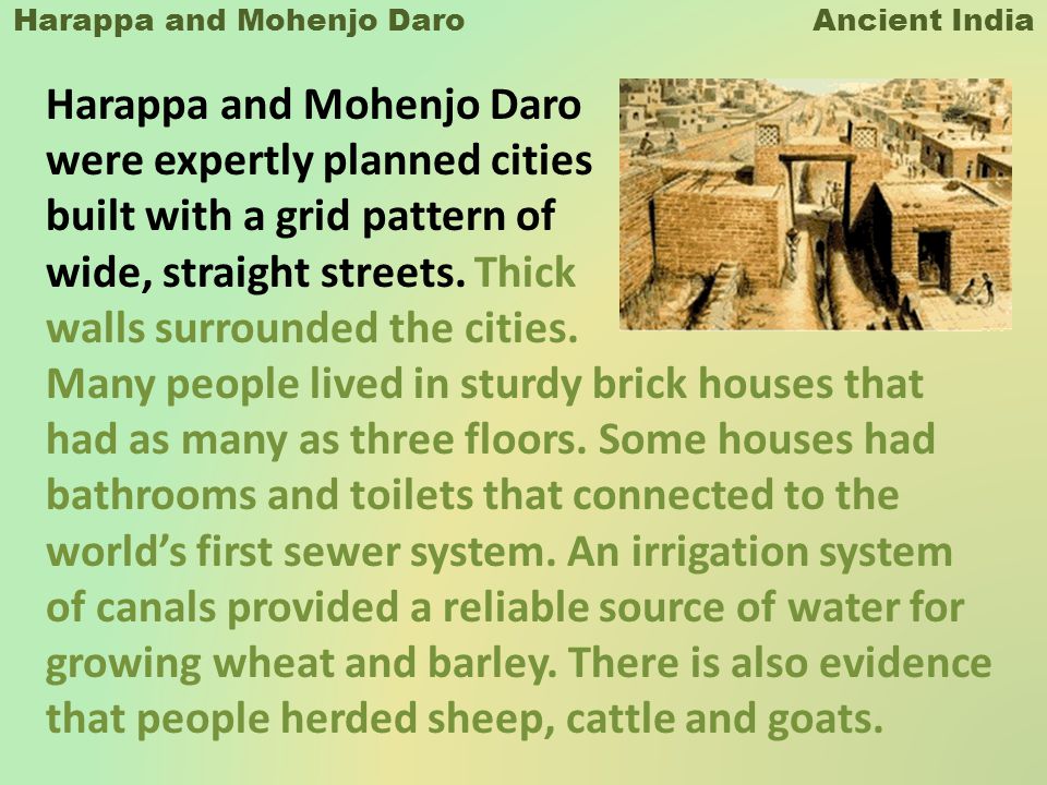
![Class 6] What is the Indus Valley Civilization also known as? Why?](https://d1avenlh0i1xmr.cloudfront.net/7792a2d8-713d-4595-b914-ff5d5fd2489d/indus-valley-civilisation---teachoo.png)
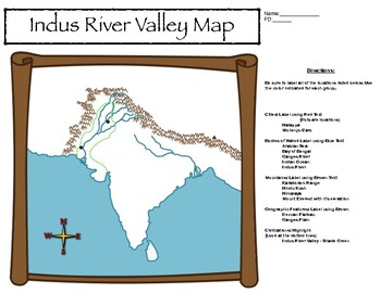
![Class 6] Describe the extent of the Indus Valley Civilization.](https://d1avenlh0i1xmr.cloudfront.net/4567e781-bde3-44e4-b2cf-2a93fbbc29c5/map-of-indus-valley-civilization---teachoo.png)