Asunción, Paraguay - The city is one of the oldest in South America. The seven hills are difficult to detect, but are: Cabara, Cerro Lambaré, Clavel, Cachinga, Cachinga, Tacumbú amd Tarumã
Lynchburg, Virginia, United States College Hill, Garland Hill, Daniel's Hill, Federal Hill, Diamond Hill, White Rock Hill, and Franklin Hill were the original "Seven Hills" of the City of Lynchburg.[10]
Nevada City, California, United States, built on Piety, Lost, Prospect, Aristocracy, Boulder, Nabob, and Buckeye Hills [11]
Worcester, Massachusetts, United States, built on Airport Hill, Bancroft Hill, Belmont Hill, Grafton Hill, Green Hill, Pakachoag Hill, and Vernon Hill.
Jerusalem, Israel This important religious center is situated on seven hills, but considering the various changes of the landscape over the centuries, it has not been possible to locate the hills on which the city rests.
Tirumala, India In Asia, there are few cities on seven hills, except in India. One of the hill town of Tirumala is precisely where the Temple of Seven Hills, the Tirumala Venkateswara. This temple is affirmed to be the most active place of worship in the world.
Bamberg, Bavaria, Germany, The seven hills of Bamberg are; Cathedral Hill, Michaelsberg, Kaulberg/Obere Pfarre, Stefansberg, Jakobsberg, Altenburger Hill, and Abtsberg.
Rome, Georgia (ISLA SAN GIORGIO EN VENECIA ESTA ENTERRADO SAN MARCOS SEGUN LA TRADICION)- ES OBVIA LA RELACION CON LA "MAQUINA DEL TIEMPO" O CON EL "EXPERIMENTO FILADELFIA"
ROME EN GEORGIA, TAMBIEN ES UNA CIUDAD SOBRE SIETE COLINAS
EVERYTHING IS CONNECTED AND THERE ARE NO COINCIDENCES
Rome was built at the confluence of the Etowah and the Oostanaula rivers, forming the Coosa River. It is on seven hills with the rivers running between them, a feature that inspired the early European-American settlers to name it for Rome, the capital of Italy. It developed as a market and trading city due to its advantageous location on the rivers, sending the cotton commodity crop downriver to the Gulf Coast.
In the late 1920s a United States company built a rayon plant in a joint project with an Italian company. This project and the American city of Rome were honored by Italy in 1929, when its dictator Benito Mussolini sent a replica of the statue of Romulus and Remus nursing from a mother wolf, a symbol of the founding myth of the original Rome.
Rome is located at the confluence of the Etowah and the Oostanaula rivers, whose merging forms the Coosa River. This gave it access to the waterways, the major transportation routes of the era. Because of this water feature, Rome developed as a regional trade center, based originally on King Cotton. As cotton plantations were developed in the area, Rome was an increasingly important market town, shipping the commodity downriver to other markets.[3] It was designated as the county seat of Floyd County, Georgia.
According to the United States Census Bureau, the city has a total area of 29.8 square miles (77 km2) of which 29.4 square miles (76 km2) is land and 0.5 square miles (1.3 km2) is water. The total area is 1.54% water.
The seven hills that inspired the name of Rome are known as Blossom, Jackson, Lumpkin, Mount Aventine, Myrtle, Old Shorter, and Neely hills. (The latter is also known as Tower or Clock Tower Hill). Some of the hills have been partially graded since Rome was founded.
People of the Mississippian culture are known to have inhabited the area from about 1000 CE. These people are believed to have died off from disease brought by exposure to the Spaniards in the late 16th century. The Cherokee migrated into the Southeast and established themselves in the early 17th century.
Specifics before the Spanish expeditions in the 16th century are largely unknown, but archeologists have found evidence of thousands of years of indigenous cultures along these rivers.
Native American territories in the Southeastern area of North America in 1715. State outlines are from later times.
There is some debate over whether Hernando de Soto was the first Spanish conquistador to encounter Native Americans in the area now known as Rome, but it is usually agreed that he passed through the region with his expedition in 1540.[4] In 1560, Tristán de Luna sent a detachment of 140 soldiers and two Dominican friars north along de Soto's route. They established relations with the Coosa chiefdom as they recorded assisting the Coosa in a raid against the rebellious province of Napochín, in what is now known as Tennessee.[5] Exposed to new Eurasian infectious diseases, these mound builder peoples suffered high mortality rates, as they lacked immunity and within 20 years the community was abandoned. The Creek emerged in the area, one of the major Muscogee-speaking tribes.[6]
The Abihka tribe of Creek in the area of Rome later became part of the Upper Creek. They merged with other Creek tribes to become the Ulibahalis, who later migrated westward into Alabama in the general region of Gadsden.[7][8] By the mid-18th century, Iroquoian-speaking Cherokee had moved into the area and occupied it. They had moved down from areas of Tennessee, under pressure from settlement by European Americans migrating from eastern territories.
A Cherokee village named Chatuga was settled in this area during the late eighteenth century, in the period of the Chickamauga Wars during and after the American Revolutionary War. The Cherokee referred to this area as "Head of Coosa." Several Cherokee leaders settled here, developing plantations, including chiefs Major Ridge and John Ross.[9] In the 20th century, Ridge's home here was preserved as Chieftains House. It has been adapted by the state for use as the Chieftains Museum and is used to represent the history of the Cherokee in this area, especially Major Ridge.
In the 18th century, a high demand in Europe for American deer skins had led to a brisk trade between Indian hunters and white traders, and as a result, a few white traders and some settlers (primarily from the British Colonies of Georgia and Carolina) were accepted by the Head of Coosa Cherokee. These were later joined by missionaries, and then more settlers. After the American War of Independence, most new settlers came from the area of Georgia east of the Proclamation Line of 1763.
1802 map of Georgia-Yazoo lands. The triangular section labeled "Assigned to Georgia 1802" was Cherokee land claimed as part of the Compact of 1802 between Georgia and the United States.
In 1802, the United States and Georgia executed the Compact of 1802, in which Georgia sold its claimed Western lands (a claim dating to the colonial era) to the United States. In return, the federal government agreed to ignore Cherokee land titles and remove all Cherokee from Georgia. The commitment to evict the Cherokee was not immediately enforced, and Chiefs John Ross and Major Ridge led efforts to stop their removal, including several Federal lawsuits.
1. 1 Samuel 23:7: Y fue dado aviso a Saúl que David había venido a Keila. Entonces dijo Saúl: Dios lo ha entregado en mi mano, pues se ha encerrado entrando en ciudad con puertas y CERRADURAS.
2. 1 Reyes 4:13: el hijo de Geber en Ramot de Galaad; éste tenía también las ciudades de Jair hijo de Manasés, las cuales estaban en Galaad; tenía también la provincia de Argob que estaba en Basán, sesenta grandes ciudades con muro y CERRADURAS de bronce;
3. Nehemías 3:3: Los hijos de Senaa edificaron la puerta del Pescado; ellos la enmaderaron, y levantaron sus puertas, con sus CERRADURAS y sus cerrojos.
4. Nehemías 3:6: La puerta Vieja fue restaurada por Joiada hijo de Paseah y Mesulam hijo de Besodías; ellos la enmaderaron, y levantaron sus puertas, con sus CERRADURAS y cerrojos.
5. Nehemías 3:13: La puerta del Valle la restauró Hanún con los moradores de Zanoa; ellos la reedificaron, y levantaron sus puertas, con sus CERRADURAS y sus cerrojos, y mil codos del muro, hasta la puerta del Muladar.
6. Nehemías 3:14: Reedificó la puerta del Muladar Malquías hijo de Recab, gobernador de la provincia de Bet-haquerem; él la reedificó, y levantó sus puertas, sus CERRADURAS y sus cerrojos. (3:14=NUMERO PI=PI-RAMIDE =EXPERIMENTO FILADELFIA= 22/7 (DIA DE MARIA LA MAGDALENA= PYRAMID= MARY)
7. Nehemías 3:15: Salum hijo de Colhoze, gobernador de la región de Mizpa, restauró la puerta de la Fuente; él la reedificó, la enmaderó y levantó sus puertas, sus CERRADURAS y sus cerrojos, y el muro del estanque de Siloé hacia el huerto del rey, y hasta las gradas que descienden de la ciudad de David.
blog.friendlyrentals.com 3 curiosidades de Roma 308 × 400 - 31k - jpg
viajesocultos.com El elegante edificio situado 399 × 599 - 35k - jpg
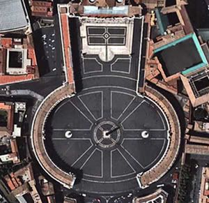
fronterasblog.wordpres... el ojo de la cerradura. 2816 × 2112 - 1038k - jpg
fronterasblog.wordpres... El ojo de la cerradura de los 2000 × 1328 - 191k - jpg
viajesocultos.com cerradura sta maria priorato 602 × 401 - 189k - jpg
the Heaven's Gate Cult that committed maSS suicide is discussed in the next post...
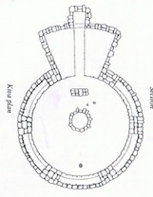
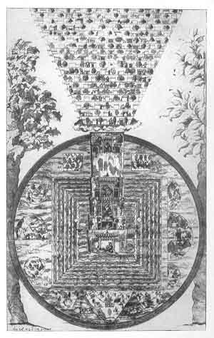
This powerful KEYHOLE shape helps explain why an evolving consciousness would build TEMPLES that resemble our own DNA. The distinct KEYHOLE or LIGHTBULB shape/form that is a perfect match for DNA expressed as binary code.
Makes sense to both ME and me shadow. We build DNA (holy grail) temples, that we can enter, and pray, chant mantras, sing, wed, bury the dead, or to help heal ourselves...by accessing/via our epi-genome which is hierarchical to our genome-mapped DNA?
namaste
p.s. what did Tesla see in his dreams?
more MEMES of course.
_________________ KEY 528=Swastika=ancient Spherical Standing Wave Theory “A theory is more impressive the greater is the simplicity of its premise, the more different are the kinds of things it relates and the more extended its range of applicability…” -Einstein
Last edited by Raphael on Tue Mar 29, 2011 7:03 pm, edited 9 times in total.
But that symbol of the KEYHOLE is still being used by some powerful groups. WHY? Think about it.
namaste
_________________ KEY 528=Swastika=ancient Spherical Standing Wave Theory “A theory is more impressive the greater is the simplicity of its premise, the more different are the kinds of things it relates and the more extended its range of applicability…” -Einstein