|
|
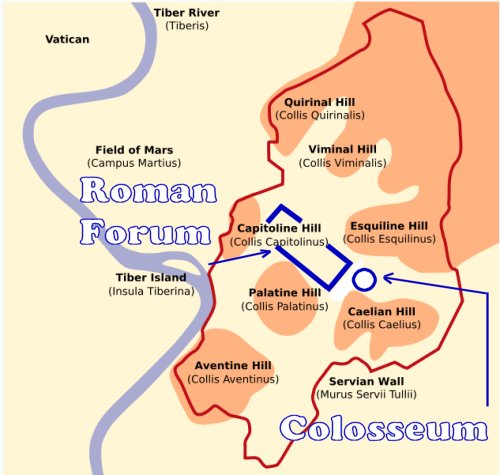
General: DOMINGO=SUNDAY (DIA DEL SOL)=LETRA S=AGUA VIVA=VENECIA=MARTE/HORUS/MARCOS
Elegir otro panel de mensajes |
|
|
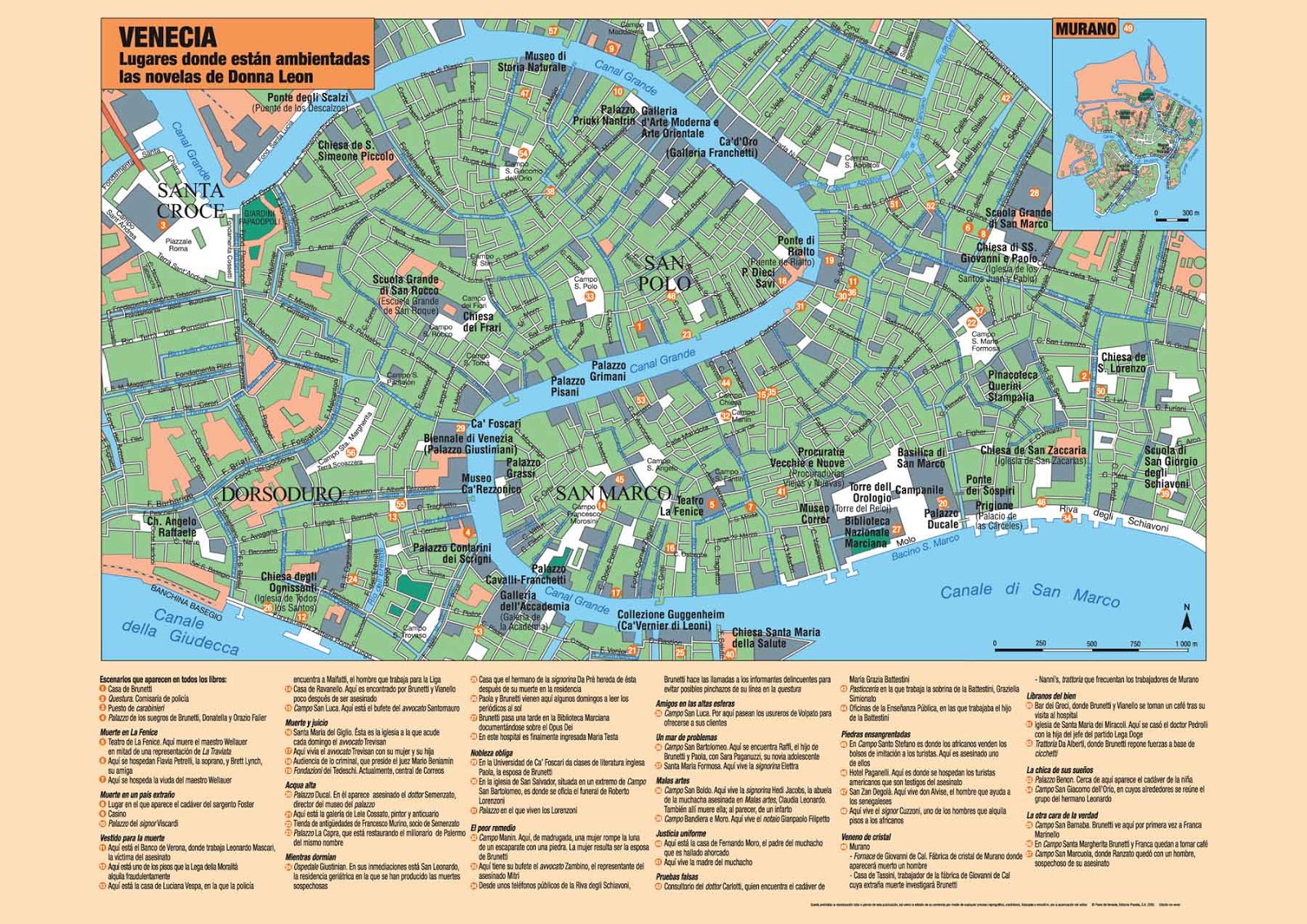
EN VENECIA ESTA EL SECRETO
|
|
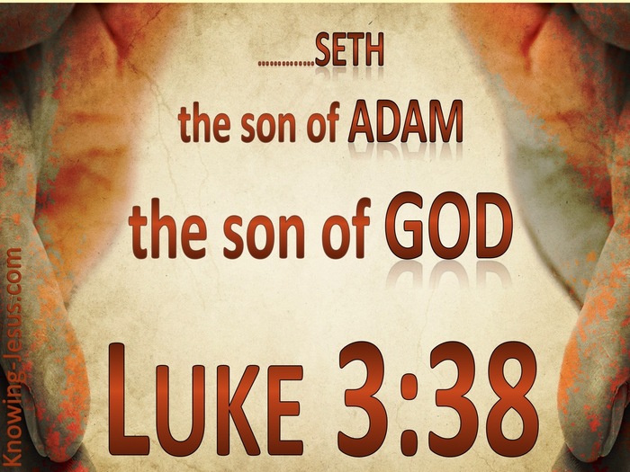
Obviamente que Dios es Dios de vivos..
Puesto que en la fe nadie muere..
Y los patriarcas Abraham, Isaac, Jacob ..
Caminaron por fe..
Dios le cambio el nombre de abram a abraham..
Porque es el primer viviente según el pacto de la circuncisión..
El primer hombre de fe, el padre de naciones..
Y ese pacto de Dios con Abraham sigue vigente hasta hoy..
Porque en la fe de Abraham son salvas todas las naciones..
Y para dejar tranquilo a Barilochense le digo :
Dios también le cambió el nombre a la mujer de Abraham..
De Saraí ( princesa ) pasó a llamarse Sara que significa madre de naciones..
16. Y la bendeciré, y también te daré de ella hijo; sí, la bendeciré, y vendrá a ser madre de naciones; reyes de pueblos vendrán de ella.
Para que no diga que Dios no ama a sus hijas..
Saludos
El Ungido
LA CLAVE DEL EXPERIMENTO FILADELFIA
|
|
|
|
|
|

Jordan River (Utah)
From Wikipedia, the free encyclopedia
The Jordan River, in the state of Utah, United States, is a river about 51 miles (82 km) long. Regulated by pumps at its headwaters at Utah Lake, it flows northward through the Salt Lake Valley and empties into the Great Salt Lake. Four of Utah's six largest cities border the river: Salt Lake City, West Valley City, West Jordan, and Sandy. More than a million people live in the Jordan Subbasin, part of the Jordan River watershed that lies within Salt Lake and Utah counties. During the Pleistocene, the area was part of Lake Bonneville.
Members of the Desert Archaic Culture were the earliest known inhabitants of the region; an archaeological site found along the river dates back 3,000 years. Mormon pioneers led by Brigham Young were the first European American settlers, arriving in July 1847 and establishing farms and settlements along the river and its tributaries. The growing population, needing water for drinking, irrigation, and industrial use in an arid climate, dug ditches and canals, built dams, and installed pumps to create a highly regulated river.
Although the Jordan was originally a cold-water fishery with 13 native species, including Bonneville cutthroat trout, it has become a warm-water fishery where the common carp is most abundant. It was heavily polluted for many years by raw sewage, agricultural runoff, and mining wastes. In the 1960s, sewage treatment removed many pollutants. In the 21st century, pollution is further limited by the Clean Water Act, and, in some cases, the Superfund program. Once the home of bighorn sheep and beaver, the contemporary river is frequented by raccoons, red foxes, and domestic pets. It is an important avian resource, as are the Great Salt Lake and Utah Lake, visited by more than 200 bird species.
Big Cottonwood, Little Cottonwood, Red Butte, Mill, Parley's, and City creeks, as well as smaller streams like Willow Creek at Draper, Utah, flow through the sub-basin. The Jordan River Parkway along the river includes natural areas, botanical gardens, golf courses, and a 40-mile (64 km) bicycle and pedestrian trail, completed in 2017.[6]
The Jordan River is Utah Lake's only outflow. It originates at the northern end of the lake between the cities of Lehi and Saratoga Springs. It then meanders north through the north end of Utah Valley for approximately 8 miles (13 km) until it passes through a gorge in the Traverse Mountains, known as the Jordan Narrows. The Utah National Guard base at Camp Williams lies on the western side of the river through much of the Jordan Narrows.[7][8] The Turner Dam, located 41.8 miles (67.3 km) from the river's mouth (or at river mile 41.8) and within the boundaries of the Jordan Narrows, is the first of two dams of the Jordan River. Turner Dam diverts the water to the right or easterly into the East Jordan Canal and to the left or westerly toward the Utah and Salt Lake Canal. Two pumping stations situated next to Turner Dam divert water to the west into the Provo Reservoir Canal, Utah Lake Distribution Canal, and Jacob-Welby Canal. The Provo Reservoir Canal runs north through Salt Lake County, Jacob-Welby runs south through Utah County. The Utah Lake Distribution Canal runs both north and south, eventually leading back into Utah Lake.[9] Outside the narrows, the river reaches the second dam, known as Joint Dam, which is 39.9 miles (64.2 km) from the river's mouth. Joint Dam diverts water to the east for the Jordan and Salt Lake City Canal and to the west for the South Jordan Canal.[10][11][12]

Map of the Salt Lake Valley
The river then flows through the middle of the Salt Lake Valley, initially moving through the city of Bluffdale and then forming the border between the cities of Riverton and Draper.[7] The river then enters the city of South Jordan where it merges with Midas Creek from the west. Upon leaving South Jordan, the river forms the border between the cities of West Jordan on the west and Sandy and Midvale on the east. From the west, Bingham Creek enters West Jordan. Dry Creek, an eastern tributary, combines with the main river in Sandy. The river then forms the border between the cities of Taylorsville and West Valley City on the west and Murray and South Salt Lake on the east. The river flows underneath Interstate 215 in Murray. Little and Big Cottonwood Creeks enter from the east in Murray, 21.7 miles (34.9 km) and 20.6 miles (33.2 km) from the mouth respectively. Mill Creek enters on the east in South Salt Lake, 17.3 miles (27.8 km) from the mouth. The river runs through the middle of Salt Lake City, where the river travels underneath Interstate 80 a mile west of downtown Salt Lake City and again underneath Interstate 215 in the northern portion of Salt Lake City. Interstate 15 parallels the river's eastern flank throughout Salt Lake County. At 16 miles (26 km) from the mouth, the river enters the Surplus Canal channel. The Jordan River physically diverts from the Surplus Canal through four gates and heads north with the Surplus Canal heading northwest. Parley's, Emigration, and Red Butte Creeks converge from the east through an underground pipe, 14.2 miles (22.9 km) from the mouth.[7] City Creek also enters via an underground pipe, 11.5 miles (18.5 km) from the river's mouth. The length of the river and the elevation of its mouth varies year to year depending on the fluctuations of the Great Salt Lake caused by weather conditions. The lake has an average elevation of 4,200 feet (1,300 m) which can deviate by 10 feet (3.0 m).[3] The Jordan River then continues for 9 to 12 miles (14 to 19 km) with Salt Lake County on the west and North Salt Lake and Davis County on the east until it empties into the Great Salt Lake.[7][8][11]
Discharge[edit]
The United States Geological Survey maintains a stream gauge in Salt Lake City that shows annual runoff from the period 1980–2003 is just over 150,000 acre-feet (190,000,000 m3) per year or 100 percent of the total 800,000 acre-feet (990,000,000 m3) of water entering the Jordan River from all sources. The Surplus Canal carries almost 60 percent of the water into the Great Salt Lake, with various irrigation canals responsible for the rest. The amount of water entering the Jordan River from Utah Lake is just over 400,000 acre-feet (490,000,000 m3) per year. Inflow from the 11 largest streams feeding the Jordan River, sewage treatment plants, and groundwater each account for approximately 15 percent of water entering the river.[13]
Watershed[edit]

Map of the entire Jordan River Basin
|
|
|
|
|

GRAN DRAGÓN ESCARLATA O BESTIA DE 7 CABEZAS:
ISLA SAN GIORGIO (VENECIA)=GEORGE LEMAITRE
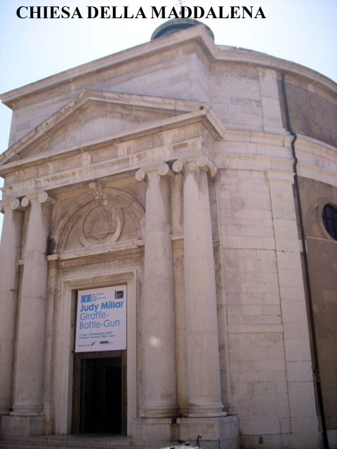
Sapientia Aedificavit Sibi Domum. Es decir, "la sabiduría ha edificado aquí su casa". Resulta curioso que la misma frase aparece en el Evangelio de María Magdalena, un texto apócrifo. Se dice que en el interior de esta iglesia y de otras muchas de Venecia está escondido el tesoro de los templarios. Pero no hay ninguna prueba de ello. Para terminar ya con esta entrada me gustaría que nos acercásemos un momento a uno de los edificios más emblemáticos de Venecia: el Palacio Ducal.

La Maddalena

Tomb of Tommaso Temanza
|
|
|
|
|
|
FATIMA=SEPTEMBER 11TH (MARS)
|
|
|
|
|
FATIMA=SEPTEMBER 11TH (MARS)/TUESDAY
MAY 1TH 1917 (FATIMA) MARS/TUESDAY
DECEMBER 25TH 1917 (FATIMA) MARS/TUESDAY
JANUARY 1TH 1918 MARS/TUESDAY
|
|
|
|
|
|
|
|
|
Calendar for Year 1917 (Gregorian calendar)
8: |
|
|
Calendar for Year 1917 (Gregorian calendar)
8: |
|
|
 Primer Anterior 2 a 3 de 3 Siguiente Primer Anterior 2 a 3 de 3 Siguiente  Último Último |
|
|
|
Calendario 1945
6:
WAR II=HIROSHIMA=1945= MARS/TUESDAY SEPTEMBER 11TH (FATIMA GATE)
|
|
|
|
|
2012 (FATIMA GATE) MARS/TUESDAY SEPTEMBER 11TH
|
|
|
|
|
|
|
|
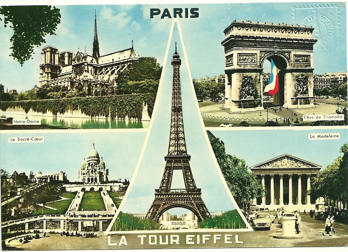
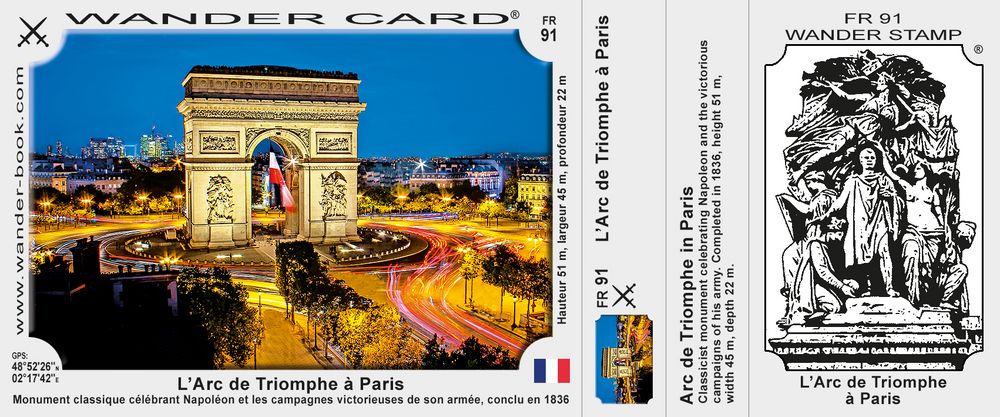
Earth from Space – Arc de Triomphe, Paris
Status Report
May 13, 2022

Arc de Triomphe, Paris.
ESA
This striking, high-resolution image of the Arc de Triomphe, in Paris, was captured by Planet SkySat – a fleet of satellites that have just joined ESA’s Third Party Mission Programme in April 2022.
The Arc de Triomphe, or in full Arc de Triomphe de l’Étoile, is an iconic symbol of France and one of the world’s best-known commemorative monuments. The triumphal arch was commissioned by Napoleon I in 1806 to celebrate the military achievements of the French armies. Construction of the arch began the following year, on 15 August (Napoleon’s birthday).
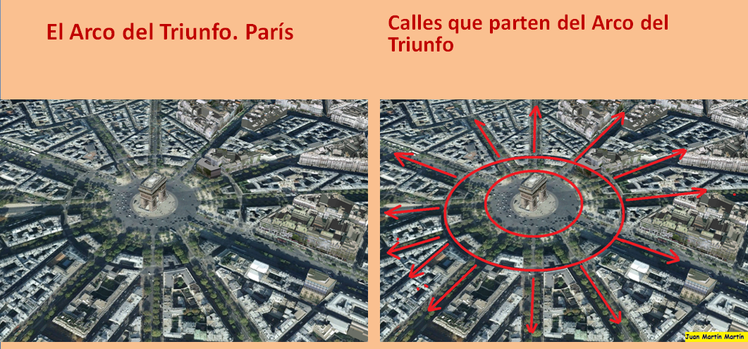
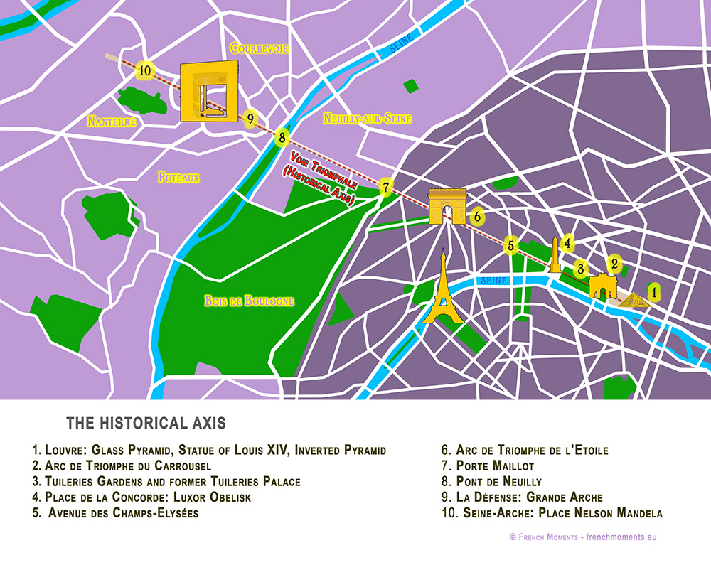
The arch stands at the centre of the Place Charles de Gaulle, the meeting point of 12 grand avenues which form a star (or étoile), which is why it is also referred to as the Arch of Triumph of the Star. The arch is 50 m high and 45 m wide.
The names of all French victories and generals are inscribed on the arch’s inner and outer surfaces, while the Tomb of the Unknown Soldier from World War I lies beneath its vault. The tomb’s flame is rekindled every evening as a symbol of the enduring nature of the commemoration and respect shown to those who have fallen in the name of France.
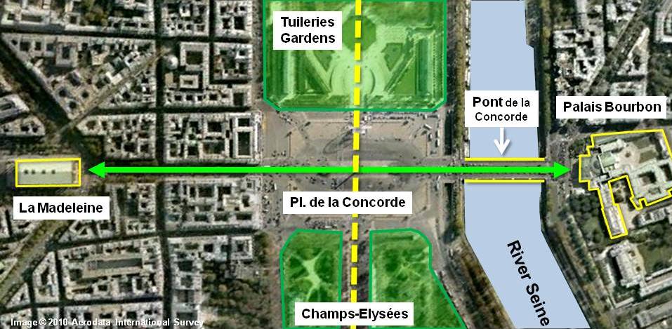
The Arc de Triomphe’s location at the Place Charles de Gaulle places it at the heart of the capital and the western terminus of the Avenue des Champs-Élysées (visible in the bottom-right of the image). Often referred to as the ‘most beautiful avenue in the world’, the Champs-Élysées is known for its theatres, cafés and luxury shops, as the finish of the Tour de France cycling race, as well as for its annual Bastille Day military parade.
This image, captured on 9 April 2022, was provided by Planet SkySat – a fleet of 21 very high-resolution satellites capable of collecting images multiple times during the day. SkySat’s satellite imagery, with 50 cm spatial resolution, is high enough to focus on areas of great interest, identifying objects such as vehicles and shipping containers.
SkySat data, along with PlanetScope (both owned and operated by Planet Labs), serve numerous commercial and governmental applications. These data are now available through ESA’s Third Party Mission programme – enabling researchers, scientists and companies from around the world the ability to access Planet’s high-frequency, high-resolution satellite data for non-commercial use.
Within this programme, Planet joins more than 50 other missions to add near-daily PlanetScope imagery, 50 cm SkySat imagery, and RapidEye archive data to this global network.
Peggy Fischer, Mission Manager for ESA’s Third Party Missions, commented, “We are very pleased to welcome PlanetScope and SkySat to ESA’s Third Party Missions portfolio and to begin the distribution of the Planet data through the ESA Earthnet Programme.
“The high-resolution and high-frequency imagery from these satellite constellations will provide an invaluable resource for the European R&D and applications community, greatly benefiting research and business opportunities across a wide range of sectors.”
To find out more on how to apply to the Earthnet Programme and get started with Planet data, click here.
– Download the full high-resolution image.
|
|
|
|
|
| Foundation stone. On August 15, 1806, Emperor Napoleon I's birthday, the foundation stone of the building was laid at a depth of eight meters, between the two southern pillars. |
|
|
|
|
| Enviado: 21/10/2024 10:30 |
|
|
|
|
|
|
|
|
 Primer
Anterior
124 a 138 de 138
Siguiente Primer
Anterior
124 a 138 de 138
Siguiente
 Último
|
|
| |
|
|
©2025 - Gabitos - Todos los derechos reservados | |
|
|