|
|
General: When a Mormon and non-Mormon engages in research about the church,
Elegir otro panel de mensajes |
|
|
| De: Alcoseri (Mensaje original) |
Enviado: 06/05/2013 22:39 |
When a Mormon and non-Mormon engages in research about the church, they will immediately discover imagery (e.g. temple, sacred garments, etc) and ceremonies (e.g. temple) which bears some resemblance to Freemasonry. Check out the internet. Typical questions which might arise: Why has the church used images and ceremonies associated with Freemasonry? If the church has no connection with Freemasonry today, why has it not removed all recognised imagery and ceremonies that will be associated with Freemasonry? Just because Mormons do not perceive the Freemasonry connection to be an issue, you should recognise non-Mormon masons and the general public might have problems. I don |
|
|
|
|
Understanding Hebrew Directions – Part IV
Continuing with the previous post on how we can understand Hebrew words and their meaning in order to better understand what Mormon is writing, specifically as it relates to the many directions and his usage of compass directions to describe the Land of Promise, as well as the Point of View of the writer or the subject of the writing. When trying to understand the writing of the ancients, such as Mormon, Nephi, et al., modern man simply cannot seem to come to grips with their point of view, but insists on putting his own thinking into the matter that is so out of alignment with that of the ancients.
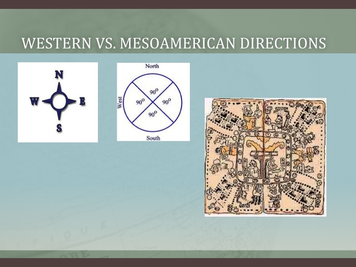
Left: The ancient Hebrews directional system contained eight compass points; Right: Our compass system today contains 32 directions. It is not just that they did not have these divisions, they did not think in terms of such minute directions
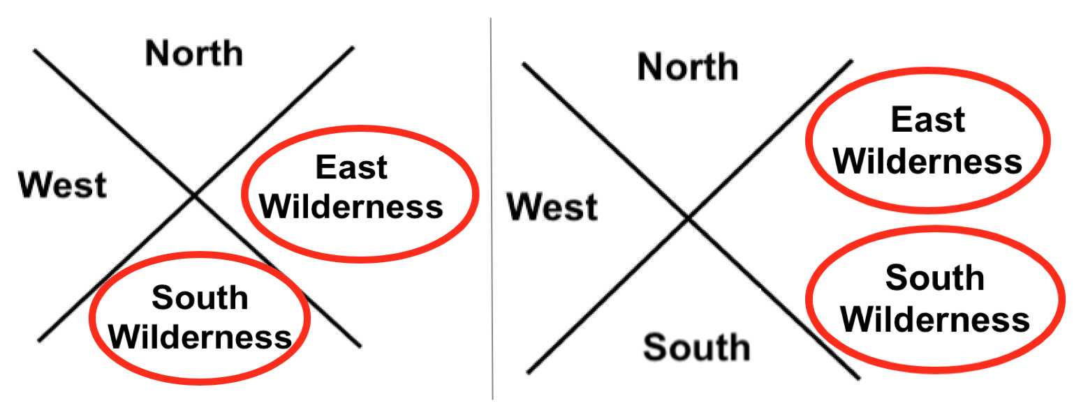
As an example, when it comes to directions, we think in far more divisions of a cardinal point than they did. Their view of their world in the sense of directions was very limited. They had limited need for anything more than the four cardinal directions, north-east-south-west, while we today use far more because we have a far greater geographical setting in our world than did the ancients. Thus, when Mormon describes an East Sea or an East Wilderness, we need to understand that it was in the east and not somewhere else. The same is true with the South Wilderness or a West Wilderness. Consequently, we need to place an East Wilderness and a South Wilderness within their proper north, east, south, and west orientation to the Point of View of the writer, which is the Land of Zarahemla.
Left: Correct usage of east and west wildernesses; Right: Incorrect. When someone places both the East and South Wilderness in the East, it is simply not something the Hebrews or Nephites would have ever done and never did do
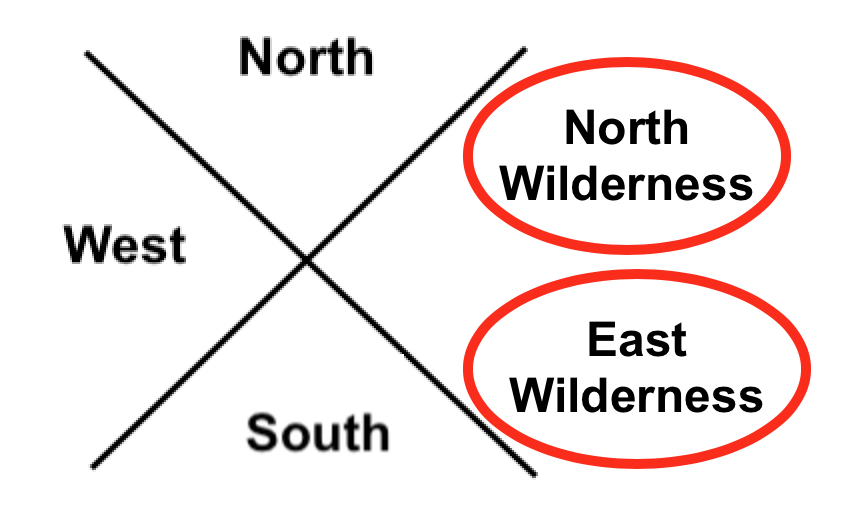
Even if we were more accurate to directions and labeled the east wilderness above as the north wilderness and the south wilderness above as the east wilderness, it would not fit Hebrew thinking.
The problem is, and always is, that the Hebrews/Jews/Nephites did not think the way we think today. First of all, they would never put a north or south anything in the east—the East was a pure direction. It was their entire being, their entire religion base, the way they drew maps, and thought of their universe. Nor would they have doubled up on two directions in a single direction, like the Mesoamericanists’ seas above or the Venice Priddis’ map. It simply would never happen—it simply is not within the Hebrew/Jewish/Nephite mindset to think that way. East of Zarahemla would be an East Wilderness, not a South Wilderness. In fact, everything to the East of Zarahemla (or even Bountiful and Nephi) would be East in Hebrew directional thinking—never anything else.
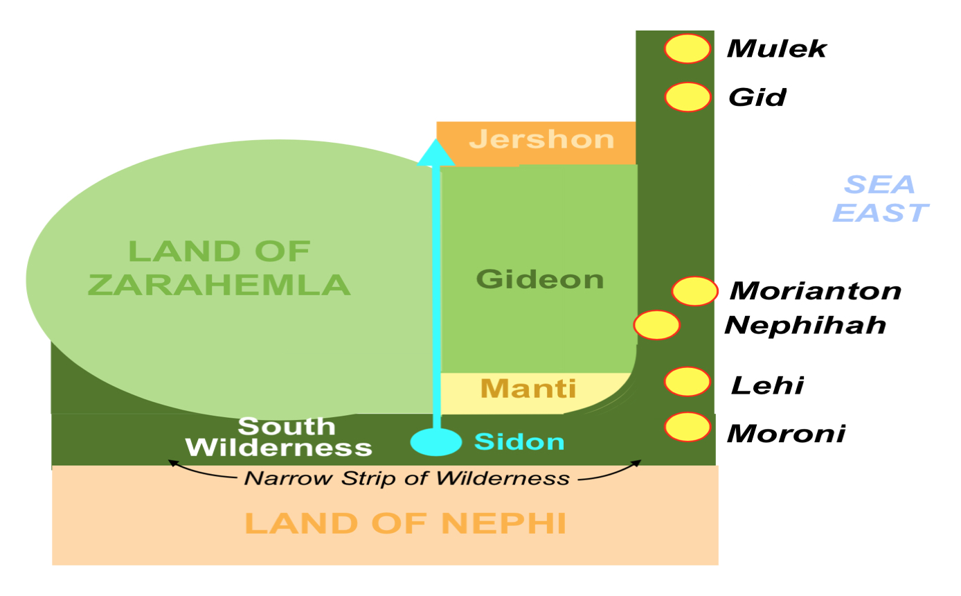
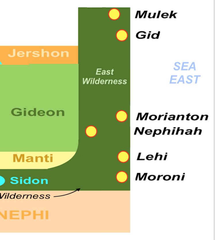
After the Lamanites were driven out of the “east wilderness” Moroni caused that the Nephites possess the land and build cities in the “east wilderness”
If a theorist places something there, then they are wrong. And if they are going to follow the overall comments of Mormon, the Nephites drove the Lamanites “out of the east wilderness” and shortly after, Mormon states: “when Moroni had driven all the Lamanites out of the east wilderness, which was north of the lands of their own possessions, he caused that the inhabitants who were in the land of Zarahemla and in the land round about should go forth into the east wilderness, even to the borders by the seashore, and possess the land” (Alma 50:9). Mormon then goes on to write: “And thus he cut off all the strongholds of the Lamanites in the east wilderness, yea, and also on the west, fortifying the line between the Nephites and the Lamanites, between the land of Zarahemla and the land of Nephi, from the west sea, running by the head of the river Sidon—the Nephites possessing all the land northward, yea, even all the land which was northward of the land Bountiful, according to their pleasure” (Alma 50:11).

Isn’t it interesting that Mormon does not mention anything about a “south wilderness” where these cities were built and from which Moroni drove out the Lamanites, yet that is exactly where some claim the South Wilderness was located. Also, in the Nephites building a city where the Lamanites had been driven out named “Moroni,” which was near the Land of Nephi, how would the Nephites drive the Lamanites out of the East Wilderness that was unattached to the Land of Nephi, with a “south wilderness” in between. Or build cities along the eastern seacoast just north of the narrow strip of land and the Land of Nephi without a mention of a south wilderness there? Of course, that is not the main point here. The point is and needs to be the basis of anything regarding directions, is the fact, and irrefutable fact, and not one of someone’s interpretation, the Hebrews and Jews, therefore the Nephites who were from that stock, and spoke and wrote Hebrew, would simply not have placed names to wildernesses as some have done. It would have violated their entire thinking process and their entire vision of the world around them. Consider someone living in Los Angeles claiming the Pacific Ocean was to their east. They woud simply laugh at you. Or someone in Salt Lake City claiming the Great Salt Lake was to the southwest, or that St. George was located in northern Utah, or Toole was located in southeast Utah. Claiming that any of these were correct, would simply be rejected by any Utahn, and most anyone else with any knowledge of the state. It would be like someone returning from a visit to Jerusalem and saying that the Muslim Quarter was in the southwestern quadrant of the city, the Dome of the Rock on the Temple Mount was beyond the New Gate into the Christian Quarter, or that the Cathedral of St. James was in the Jewish Quarter. Unless you had been there, lived there, or studied the city, you might accept those comments—but they would be completely incorrect, as any resident of Jerusalem would readily know. What if someone wrote a book about Jerusalem and listed Zion’s Gate as being in the Armenian Quarter, Tanner’s Gate being in the Christian Quarter, Lion’s Gate being in the Muslim Quarter, and the Dung Gate being in the Jewish Quarter? Or stated that Jesus went to the Pool of Siloam in the Upper City, walked along the wall of the Lower City? Would you know if those geographical statements were correct or incorrect? Actually six of those eight statements are geographically wrong. But how would you know that without study? Yet, people pick up a book written by someone, read their theory about the Great Lakes, the Heartland, or eastern U.S. and accept what they say without knowing how inaccurate they are. Some get so interested, they parrot the comments and the beliefs without ever coming to a knowledge of their inaccuracy. When it comes to the directions in the scriptural record, it is imperative to understand that in the ancient world, names did not carry much weight in meaning to a lone traveler or to an individual trying to find his way around an unknown city. However, directional names were readily apparent. You can call something the “water gate,” but calling it the “southeast gate,” means far more. Just like the “Road to the East Sea,” meant far more to someone than “Hezekiah’s Road,” and would be far more likely to know where it was located. The same is true of calling it Nehemiah’s Wall or the “north wall.” The point is, ancient directions are not something to playh around with and make all sorts of absurd claims that might make sense to a modern thinker, but would have been simply unusable and, therefore, not accurate, to the ancient world and ancient-thinking people. Directions were critical to survival, or at least in understanding the world around them. The ancients built elaborate structures and systems in order to simply know what any modern child can learn by looking at a calendar or acquiring a rudimentary understanding of planting cycles. Therefore, when Mormon used directions, he was not only thinking in terms of the way things were called and understood anciently, but he was also providing us with a better understanding of the directions of the Land of Promise and the location of lands and areas within it. There is simply no question that before the Hebrews and many other ancient peoples came into a more modern and mobile world, their vision of their land and the world around them was very limited and direction-driven. Everything about their language, their words, the scriptural meaning, the work of uncounted rabbis continually studying the ancient language and to understand it and its deeper meanings, all support the understanding of singular directional placement and naming. It simply cannot be violated because of modern ideas and modern interpretation of ancient writings. For this or that theorist to make such ridiculous claims about directions that runs contrary to that understanding and the Hebrew mindset about directions and his ancient understanding of his world is so without merit, that it is not only confusing to modern man, but downright fallacious and unworthily misleading. |
|
|
|
|

Understanding Hebrew Directions – Part IV
Continuing with the previous post on how we can understand Hebrew words and their meaning in order to better understand what Mormon is writing, specifically as it relates to the many directions and his usage of compass directions to describe the Land of Promise, as well as the Point of View of the writer or the subject of the writing. When trying to understand the writing of the ancients, such as Mormon, Nephi, et al., modern man simply cannot seem to come to grips with their point of view, but insists on putting his own thinking into the matter that is so out of alignment with that of the ancients.
Left: The ancient Hebrews directional system contained eight compass points; Right: Our compass system today contains 32 directions. It is not just that they did not have these divisions, they did not think in terms of such minute directions
As an example, when it comes to directions, we think in far more divisions of a cardinal point than they did. Their view of their world in the sense of directions was very limited. They had limited need for anything more than the four cardinal directions, north-east-south-west, while we today use far more because we have a far greater geographical setting in our world than did the ancients. Thus, when Mormon describes an East Sea or an East Wilderness, we need to understand that it was in the east and not somewhere else. The same is true with the South Wilderness or a West Wilderness. Consequently, we need to place an East Wilderness and a South Wilderness within their proper north, east, south, and west orientation to the Point of View of the writer, which is the Land of Zarahemla.
Left: Correct usage of east and west wildernesses; Right: Incorrect. When someone places both the East and South Wilderness in the East, it is simply not something the Hebrews or Nephites would have ever done and never did do
Even if we were more accurate to directions and labeled the east wilderness above as the north wilderness and the south wilderness above as the east wilderness, it would not fit Hebrew thinking.
The problem is, and always is, that the Hebrews/Jews/Nephites did not think the way we think today. First of all, they would never put a north or south anything in the east—the East was a pure direction. It was their entire being, their entire religion base, the way they drew maps, and thought of their universe. Nor would they have doubled up on two directions in a single direction, like the Mesoamericanists’ seas above or the Venice Priddis’ map. It simply would never happen—it simply is not within the Hebrew/Jewish/Nephite mindset to think that way. East of Zarahemla would be an East Wilderness, not a South Wilderness. In fact, everything to the East of Zarahemla (or even Bountiful and Nephi) would be East in Hebrew directional thinking—never anything else.
After the Lamanites were driven out of the “east wilderness” Moroni caused that the Nephites possess the land and build cities in the “east wilderness”
If a theorist places something there, then they are wrong. And if they are going to follow the overall comments of Mormon, the Nephites drove the Lamanites “out of the east wilderness” and shortly after, Mormon states: “when Moroni had driven all the Lamanites out of the east wilderness, which was north of the lands of their own possessions, he caused that the inhabitants who were in the land of Zarahemla and in the land round about should go forth into the east wilderness, even to the borders by the seashore, and possess the land” (Alma 50:9). Mormon then goes on to write: “And thus he cut off all the strongholds of the Lamanites in the east wilderness, yea, and also on the west, fortifying the line between the Nephites and the Lamanites, between the land of Zarahemla and the land of Nephi, from the west sea, running by the head of the river Sidon—the Nephites possessing all the land northward, yea, even all the land which was northward of the land Bountiful, according to their pleasure” (Alma 50:11).
Isn’t it interesting that Mormon does not mention anything about a “south wilderness” where these cities were built and from which Moroni drove out the Lamanites, yet that is exactly where some claim the South Wilderness was located. Also, in the Nephites building a city where the Lamanites had been driven out named “Moroni,” which was near the Land of Nephi, how would the Nephites drive the Lamanites out of the East Wilderness that was unattached to the Land of Nephi, with a “south wilderness” in between. Or build cities along the eastern seacoast just north of the narrow strip of land and the Land of Nephi without a mention of a south wilderness there? Of course, that is not the main point here. The point is and needs to be the basis of anything regarding directions, is the fact, and irrefutable fact, and not one of someone’s interpretation, the Hebrews and Jews, therefore the Nephites who were from that stock, and spoke and wrote Hebrew, would simply not have placed names to wildernesses as some have done. It would have violated their entire thinking process and their entire vision of the world around them. Consider someone living in Los Angeles claiming the Pacific Ocean was to their east. They woud simply laugh at you. Or someone in Salt Lake City claiming the Great Salt Lake was to the southwest, or that St. George was located in northern Utah, or Toole was located in southeast Utah. Claiming that any of these were correct, would simply be rejected by any Utahn, and most anyone else with any knowledge of the state. It would be like someone returning from a visit to Jerusalem and saying that the Muslim Quarter was in the southwestern quadrant of the city, the Dome of the Rock on the Temple Mount was beyond the New Gate into the Christian Quarter, or that the Cathedral of St. James was in the Jewish Quarter. Unless you had been there, lived there, or studied the city, you might accept those comments—but they would be completely incorrect, as any resident of Jerusalem would readily know. What if someone wrote a book about Jerusalem and listed Zion’s Gate as being in the Armenian Quarter, Tanner’s Gate being in the Christian Quarter, Lion’s Gate being in the Muslim Quarter, and the Dung Gate being in the Jewish Quarter? Or stated that Jesus went to the Pool of Siloam in the Upper City, walked along the wall of the Lower City? Would you know if those geographical statements were correct or incorrect? Actually six of those eight statements are geographically wrong. But how would you know that without study? Yet, people pick up a book written by someone, read their theory about the Great Lakes, the Heartland, or eastern U.S. and accept what they say without knowing how inaccurate they are. Some get so interested, they parrot the comments and the beliefs without ever coming to a knowledge of their inaccuracy. When it comes to the directions in the scriptural record, it is imperative to understand that in the ancient world, names did not carry much weight in meaning to a lone traveler or to an individual trying to find his way around an unknown city. However, directional names were readily apparent. You can call something the “water gate,” but calling it the “southeast gate,” means far more. Just like the “Road to the East Sea,” meant far more to someone than “Hezekiah’s Road,” and would be far more likely to know where it was located. The same is true of calling it Nehemiah’s Wall or the “north wall.” The point is, ancient directions are not something to playh around with and make all sorts of absurd claims that might make sense to a modern thinker, but would have been simply unusable and, therefore, not accurate, to the ancient world and ancient-thinking people. Directions were critical to survival, or at least in understanding the world around them. The ancients built elaborate structures and systems in order to simply know what any modern child can learn by looking at a calendar or acquiring a rudimentary understanding of planting cycles. Therefore, when Mormon used directions, he was not only thinking in terms of the way things were called and understood anciently, but he was also providing us with a better understanding of the directions of the Land of Promise and the location of lands and areas within it. There is simply no question that before the Hebrews and many other ancient peoples came into a more modern and mobile world, their vision of their land and the world around them was very limited and direction-driven. Everything about their language, their words, the scriptural meaning, the work of uncounted rabbis continually studying the ancient language and to understand it and its deeper meanings, all support the understanding of singular directional placement and naming. It simply cannot be violated because of modern ideas and modern interpretation of ancient writings. For this or that theorist to make such ridiculous claims about directions that runs contrary to that understanding and the Hebrew mindset about directions and his ancient understanding of his world is so without merit, that it is not only confusing to modern man, but downright fallacious and unworthily misleading. |
|
|
|
|
KING DAVID / JOSEPH / SOLOMON
|
|
|
|
|
https://www.4biddenknowledge.tv/videos/ep-6
https://www.4biddenknowledge.tv/videos/ep-6
|
|
|
|
|
Today is Saturday, July 24, the 205th day of 2021. There are 160 days left in the year.
Today’s Highlight in History:
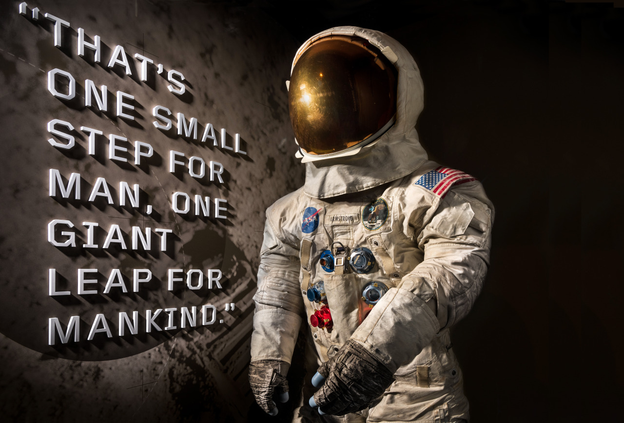
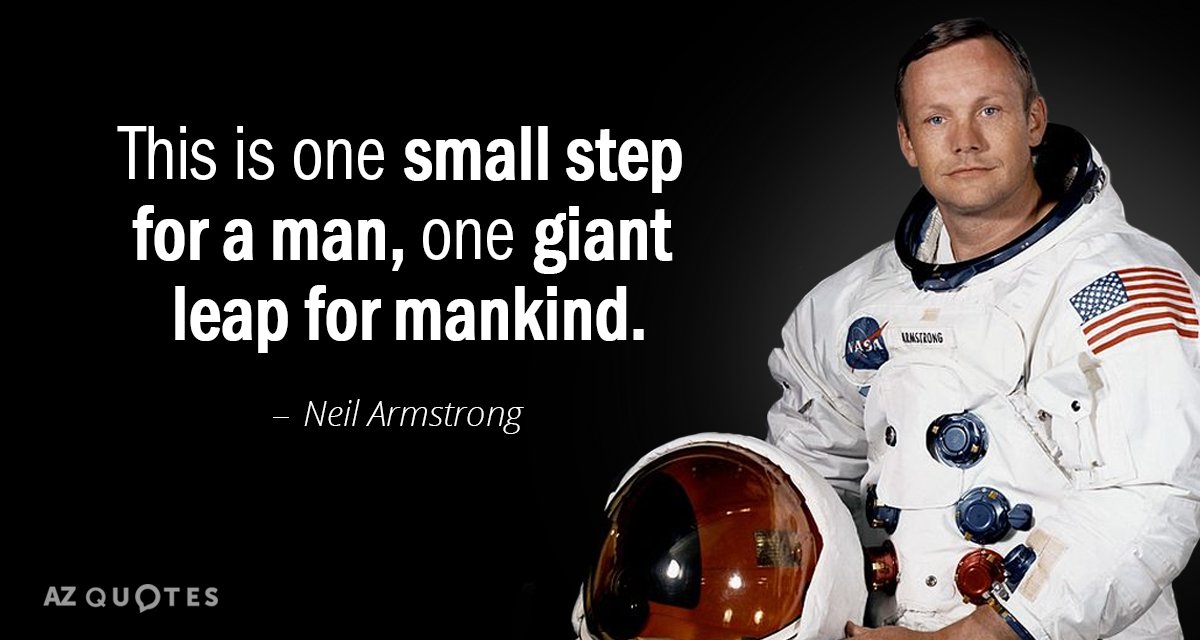
On July 24, 1969, the Apollo 11 astronauts — two of whom had been the first men to set foot on the moon — splashed down safely in the Pacific.
 CLICK HERE to see the full Chicago Tribune front page from July 25, 1969 CLICK HERE to see the full Chicago Tribune front page from July 25, 1969
On this date:
In 1567, Mary, Queen of Scots was forced to abdicate by Scottish nobles in favor of her infant son James, who became King of Scotland at the age of one.
In 1847, Mormon leader Brigham Young and his followers arrived in the Great Salt Lake Valley in present-day Utah.
In 1858, Republican senatorial candidate Abraham Lincoln formally challenged Democrat Stephen A. Douglas to a series of political debates; the result was seven face-to-face encounters.
In 1862, Martin Van Buren, the eighth president of the United States, and the first to have been born a U.S. citizen, died at age 79 in Kinderhook, New York, the town where he was born in 1782.
In 1866, Tennessee became the first state to be readmitted to the Union after the Civil War.
In 1915, the SS Eastland, a passenger ship carrying more than 2,500 people, rolled onto its side while docked at the Clark Street Bridge on the Chicago River; an estimated 844 people died in the disaster.
In 1937, the state of Alabama dropped charges against four of the nine young Black men accused of raping two white women in the “Scottsboro Case.”
In 1952, President Harry S. Truman announced a settlement in a 53-day steel strike. The Gary Cooper western “High Noon” had its U.S. premiere in New York.
In 1974, the U.S. Supreme Court unanimously ruled that President Richard Nixon had to turn over subpoenaed White House tape recordings to the Watergate special prosecutor.
In 1975, an Apollo spacecraft splashed down in the Pacific, completing a mission which included the first-ever docking with a Soyuz capsule from the Soviet Union.
In 2010, a stampede inside a tunnel crowded with techno music fans left 21 people dead and more than 500 injured at the famed Love Parade festival in western Germany.
In 2019, in a day of congressional testimony, Robert Mueller dismissed President Donald Trump’s claim of “total exoneration” in Mueller’s probe of Russia’s 2016 election interference.
RELATED: 6 books examining Chicago and its history
Ten years ago: Cadel (kuh-DEHL’) Evans won the Tour de France, becoming the first Australian champion in cycling’s greatest race.
Five years ago: Thousands of demonstrators took to Philadelphia’s sweltering streets in the first major protests ahead of the Democratic National Convention. Ken Griffey Jr. and Mike Piazza were inducted into the Baseball Hall of Fame. British rider Chris Froome celebrated his third Tour de France title in four years. Hollywood “ghost singer” Marni Nixon, 86, died in New York.
One year ago: U.S. agents again used tear gas to try to disperse a large crowd of protesters outside the federal courthouse in Portland, Oregon, after fireworks were shot toward the building amid raucous demonstrations. A federal judge denied a request by Oregon’s attorney general to restrict the actions of federal police who’d been deployed there amid weeks of protests over the death of George Floyd. President Donald Trump scrapped plans for a four-night Republican National Convention celebration in Florida, citing a “flare-up” of the coronavirus. Former Trump lawyer Michael Cohen was released from prison after a federal judge ruled that a move to revoke his home confinement was retaliation for his plan to release a book critical of Trump. Alec McKinney, 17, the younger of two teens charged in a fatal shooting at a suburban Denver school in 2019, was sentenced to life in prison plus 38 years. Television personality Regis Philbin, remembered for his syndicated morning show and for “Who Wants to Be a Millionaire,” died at 88.
Today’s birthdays: Actor John Aniston is 88. Political cartoonist Pat Oliphant is 86. Comedian Ruth Buzzi is 85. Actor Mark Goddard is 85. Actor Dan Hedaya is 81. Actor Chris Sarandon is 79. Comedian Gallagher is 75. Actor Robert Hays is 74. Former Republican national chairman Marc Racicot (RAWS’-koh) is 73. Actor Michael Richards is 72. Actor Lynda Carter is 70. Movie director Gus Van Sant is 69. Former Sen. Claire McCaskill, D-Mo., is 68. Country singer Pam Tillis is 64. Actor Paul Ben-Victor is 59. Basketball Hall of Famer Karl Malone is 58. Retired MLB All-Star Barry Bonds is 57. Actor Kadeem Hardison is 56. Actor-singer Kristin Chenoweth is 53. Actor Laura Leighton is 53. Actor John P. Navin Jr. is 53. Actor-singer Jennifer Lopez is 52. Basketball player-turned-actor Rick Fox is 52. Director Patty Jenkins (“Wonder Woman”) is 50. Actor Jamie Denbo (TV: “Orange is the New Black”) is 48. Actor Eric Szmanda is 46. Actor Rose Byrne is 42. Country singer Jerrod Niemann is 42. Actor Summer Glau is 40. Actor Sheaun McKinney is 40. Actor Elisabeth Moss is 39. Actor Anna Paquin is 39. Actor Sarah Greene is 37. NHL center Patrice Bergeron is 36. Actor Megan Park is 35. Actor Mara Wilson is 34. Actor Sarah Steele is 33. Rock singer Jay McGuiness (The Wanted) is 31. Actor Emily Bett Rickards is 30. Actor Lucas Adams is 28. TV personality Bindi Irwin is 23.
https://www.chicagotribune.com/2021/07/24/this-day-in-history-july-24-apollo-11-astronauts-two-of-whom-had-been-the-first-men-to-set-foot-on-the-moon-splash-down-safely-in-the-pacific/ |
|
|
|
|
First, NYC/Long Island can be associated with 'knowledge' through the symbolisms of 'apple' ("Big Apple"), 'rose' (state flower), 'fire' (Statue of Liberty, its connection to Paris/'torch'), etc. and as we've seen in foregoing sections it's part of the 'ark' complex via VI-97. Furthermore from the 'apple' connection follows the notion of the 'serpent'. Now, all those 'knowledge'/Sirius connections of NYC can be transferred to Mars because, as illustrated in 'Babylon Matrix', NYC is also related to Mars, especially the Cydonia region with all the potentially artificial structures. Mars being red and circular is associatable with the 'apple', the red and round 'Big Apple' (NYC). Now, some might argue that the fruit Eve ate was not necessarily an 'apple', but we generally thought of it as an apple today and that has to count in symbolism. But there is a much more precise connection - the latitudes of NYC and Cydonia are exactly the same, 40.5~41N.
The events closely associated earlier with X-72 and more or less with the ark, the two random shootings in a library and school ('Resonance' #7 and 8), appear to back up the Mars-Sirius connection also. Those two similar events, only five days apart, occurred one on the Cydonian latitude and the other on the Sirius 'angle' latitude. The Mormon library shooting took place at ~40.5N, and the Colorado school shooting at ~39.5N. The name 'Salt Lake City', where the library shooting occurred, may be relevant also since mythologically the 'salt water' is of female - and Sirius is filled with female associations ('goddess', 'star of Women', etc.).
Moreover, Temple mentions in his book that "when making rhetorical allusion to the Dog Days, the Latins would often speak of Sirius being red at the time..." Now, this is quite significant for not only is Sirius described as 'red' like Mars, but the "Dog Days" would refer to a period in or around July - the exact time-frame indicated by Quatrain X-72.
The Sirius-correlated Argo also turns out to be very relevant here. Because the main mission of Jason, the leader of the Argonauts who has been identified as the "appeasing King"/"King of terror" of X-72 earlier, was to obtain the 'golden fleece', and in Temple's words, "Aries was definitely identified with the golden fleece". In case you don't know, Aries is the Greek Mars. Aries is also a sign of the zodiac, "ruled" by Mars, and it is classified as a 'fire sign' - correlating with the fire-knowledge symbolism. I should also point out that Mars is called 'fire star' in Japanese.
Moreover, Sirius/Isis' son Horus provides intriguing correlations. First, the Great Sphinx associated earlier with 'ark' was called by Egyptians "Horus of Horizon" which also happens to be a name given to Mars. And the word 'Cairo', where the Sphinx is (actually slightly west of Cairo), is derived from 'Mars'. Mars was also called 'Horus the Red'. And the word 'Heru' (Egyptian name for Horus) also has the meaning of 'face' - seemingly a reference to the infamous 'Face on Mars' at Cydonia! (So, as you can see, the Mars-Horus connection is quite obvious.) Next, Sirius/ark comes into the web of associations, as the Argo also relates to Horus (thus to Mars too) as the Greek derivation of Horus, 'Circe', plays a prominent role in the story of Argo. Also, as Temple hypothesizes, the names of the original captain of Argo, Herakles, and his protectress Hera may be derived from 'Heru' - the Egyptian name for Horus. Furthermore, we're told that Herakles/Hera is related to the word 'Seirios' from which we have the word 'Sirius' - strengthening the Mars-ark-Sirius connection. But as if it wasn't enough, Temple goes on to point out that 'Seirios' also has the meaning of 'fiery/scorching', that can easily be a reference to Mars.

And finally, Mars and Sirius are linked by the 'tetrahedral angle' of 19.5 degrees. '19.5 degrees' is one of the most significant notions derived from the supposed artificial structures of Cydonia that suggests their artificiality, according to investigators like Richard Hoagland ('The Monuments of Mars'). It is viewed as a definite 'signal in the noise' - some kind of a 'message' left there by some intelligence. This number, '19.5', is called t, the 'tetrahedral constant', because of  its significance in tetrahedral geometry (a tetrahedron is a pyramid shape composed of four equilateral triangular sides): the apexes of a tetrahedron when placed within a circumscribing sphere, one of the tetrahedron's apexes touching the south (or north) pole, the other three apexes touch the surface of the sphere at 19.5 degrees north latitude. So it is interesting that the Egyptian symbol for Sirius is a triangle which can be viewed as a 2-dimensional representation of a tetrahedron. its significance in tetrahedral geometry (a tetrahedron is a pyramid shape composed of four equilateral triangular sides): the apexes of a tetrahedron when placed within a circumscribing sphere, one of the tetrahedron's apexes touching the south (or north) pole, the other three apexes touch the surface of the sphere at 19.5 degrees north latitude. So it is interesting that the Egyptian symbol for Sirius is a triangle which can be viewed as a 2-dimensional representation of a tetrahedron.
https://www.goroadachi.com/etemenanki/1999-sirius.htm |
|
|
 Primer
Anterior
24 a 38 de 38
Siguiente Primer
Anterior
24 a 38 de 38
Siguiente
 Último
|
|
| |
|
|
©2025 - Gabitos - Todos los derechos reservados | |
|
|


![That's one small step..." —Neil Armstrong [1024 x 1333] : r/QuotesPorn](https://i.imgur.com/lfLGX.jpg)