EL DIA 17 DEL SEGUNDO MES (DIA DEL DILUVIO UNIVERSAL), EN LA SECUENCIA LUNAR DE 1982, ME CAYO EL DIA 25 DE ABRIL (DIA DE SAN MARCOS)-¿QUE NOS QUIERE DECIR YHWH DETRAS DE LA GUERRA DE MALVINAS?-RELACION CON EL NACIMIENTO DEL PRINCIPE WILLIAM EL 21 DE JUNIO (PUERTA DE PLATA/ARGENTUM /SILVER GATE)
SHAVUOT JUSTO EL 20 DE JUNIO (SOLSTICIO) EN EL AÑO 1997. APARENTEMENTE EL 22 DE FEBRERO ES EL PISO PARA EL VERDADERO ROSH HASHANAH (AÑO NUEVO) HEBREO. TAMBIEN SE CUMPLIO DE ESA FORMA EN LOS AÑOS 1978, 1959, 1940 Y SERA ASI EN EL 2016, OSEA EN EL AÑO DEL BICENTENARIO DE LA INDEPENDENCIA ARGENTINA.
ROSH HASHANAH =RH = 1/1 =1 /NISSAN
LEVADURAS =LEV=15/1 =15/NISSAN
SHAVUOT =SHA=1 /5 =1 /AV (APROXIMADO)
13 DE ELUL =ELU=13/6 =13/ELUL
TROMPETAS =TRO=1 /7 =1 /TISHRI
YOM KIPUR =YK =10/7 =10/TISHRI (COMIENZA EN EL 9 DE TISHRI-LEVITICO 23:32)
JANUKAH(8VO DIA)=TEV= 1/10= 1/TEVET (GENESIS 8:5/CALENDARIO DE NOE)
11/11 (DIA N-306) =SHE=11/11=11/SHEVAT (GENESIS 8:6/CALENDARIO DE NOE)
PURIM =PUR=15/12=15/ADAR (14 Y 15 DE ADAR-ESTHER 9)
Génesis 7
11. El año seiscientos de la vida de Noé, en el mes segundo, a los diecisiete días del mes, aquel día fueron rotas todas las fuentes del grande abismo, y las cataratas de los cielos fueron abiertas, (El 17 del segundo mes es el 47 dia del calendario hebreo, osea que tiene relacion con la INDEPENDENCIA DE LOS ESTADOS UNIDOS Y EL DIA DE SAN MARCOS)
RH LEV SHA ELU TRO YK TAB STO JAN TEV 11/11 PUR VEADAR
YOM KIPUR=12 DE SEPTIEMBRE (9 DE TISHRI (LEVITICO 23:32)=11 DE SEPTIEMBRE
TABERNACULOS=17 DE SEPTIEMBRE
SIMCHAT TORA=24 DE SEPTIEMBRE
JANUKAH=24 DE NOVIEMBRE
1/10(GENESIS 8:5)=1 DE DICIEMBRE
11/11=9 DE ENERO
PURIM=9 Y 10 DE FEBRERO
T
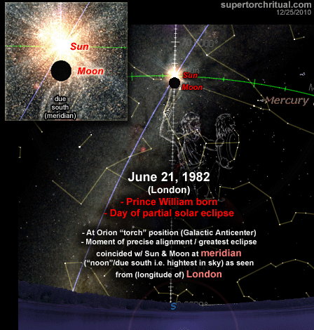
he Moon turned blood-red exactly (and necessarily for any total lunar eclipse) 180 degrees away from the solstice Sun so as to become in effect the 'torch of Orion'
at/near the Galactic Anticenter or the intersection of the Galactic Equator and the ecliptic (see picture above). It's where the Sun annually finds itself on the summer solstice, ~June 21, the date of Prince William's birth in 1982 from the lunar womb of Diana (= Roman moon goddess) which was also marked by a partial solar eclipse.
EFECTIVAMENTE ARGENTUM/PUERTA DE PLATA ES UNA REFERENCIA A ORION/MERCURIO/ SOLSTICIO DE VERANO EN EL HEMISFERIO NORTE Y SOLSTICIO DE INVIERNO EN EL HEMISFERIO SUR. EL VERDADERO MENSAJE DETRAS DE LA GUERRA/MARTE/SANGRE/LINAJE DE MALVINAS CONTRA INGLATERRA/REINA DE LOS MARES CUYA BANDERA MISMA ES UNA REFERENCIA A ORION ES EL NACIMIENTO DEL PRINCIPE WILLIAMS COMO SIMBOLO DEL GRIAL, cuyo nacimiento fue el 21 de junio de 1982. CONCRETAMENTE ESTE ES EL VERDADERO MENSAJE DE LA GUERRA DE MALVINAS. Esto tambien explica la conexion del PAPA JUAN PABLO II en la pacificacion ENTRE INGLATERRA Y LA ARGENTINA. JUAN PABLO/PEQUEÑO/BENJAMIN/PERRO/CHACAL/LOBO (GENESIS 49:27) ES UNA REFERENCIA A JUAN MARCOS EN FORMA ESOTERICA Y MAS EN EL MISMO CONTEXTO AL DISEÑO DE VATICANO EN FUNCION A LAS PLEYADES, SIRIO Y ORION
ARGENTINA/ ARGENTUM/ PLATA/ PUERTA DE PLATA / ORION-MERCURIO / HYDRARGYROS-ARGYROS=PLATA / SECRETO DETRAS DEL PAPA ARGENTINO
But the most intriguing and central in the whole pattern is the "end of the papacy/Church/Christianity" storyline. Ominously it goes well with curiously accurate St. Malachy's papal prophecy...
The Prophecy of the Popes is a series of 112 short, cryptic phrases in Latin which purport to predict the Roman Catholic popes (along with a few antipopes), beginning with Pope Celestine II. The alleged prophecies were first published by Benedictine monk Arnold Wion in 1595. Wion attributes the prophecies to Saint Malachy, a 12th-century Archbishop of Armagh, Ireland.
According to the prophecy, Pope Francis would correspond to the final pope on the list called "Peter the Roman". (This correspondence is not certain as there is some ambiguity at the end of the pope list, but Francis would definitely be one the final popes.)
Pope Benedict XVI was #111 on the list with the motto "Glory of the Olive". It is then followed by a set of sentences - not just a short motto, but two paragraphs - describing the next/final pope or the next two (or more) final popes...
In persecutione extrema S.R.E. sedebit.
Petrus Romanus, qui pascet oves in multis tribulationibus, quibus transactis civitas septicollis diruetur, & judex tremedus judicabit populum suum. Finis.
In the extreme persecution of the Holy Roman Church, there will sit.
Peter the Roman, who will pasture his sheep in many tribulations, and when these things are finished, the city of seven hills [i.e. Rome] will be destroyed, and the terrible judge will judge his people. The End.
They clearly describe the end of the Roman Catholic Church, the end of Rome. And it sounds as if this great destruction would come after the reign of "Peter the Roman". That would mean after Pope Francis. If we are in fact getting a multicontextual foreshadowing of 2017 signaling a situation very similar to St. Malachy's "Peter the Roman" prophecy, that would imply the exit of Pope Francis within a year or so, followed by the Fall of the Church and with it the Age of Pisces (Fish).
Of course, the big question is, is Pope Francis really Peter the Roman? No way to be sure obviously. But there are intriguing hints.
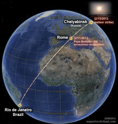
Remember the "sign in the sky" at the time of Pope Benedict's resignation (2013) which also produced a geo-alignment pinpointing Rio (discussed in Part 1)?
Feb 11, 2013: Pope Benedict XVI announces resignation Feb 15, 2013: Major meteor impact in Chelyabinsk, Russia
Note that "Peter" means "rock". Meteors are "rocks fallen from heaven". So the mid-February 2013 double impact event in effect telegraphed "(space) rock Rome" or "Peter the Roman"!
And out of this "Peter the Roman" event came Pope Francis, introduced to the world on March 13, 2013.
As discussed in Part 1 the very first foreign land he officially visited as the pope was... Rio de Janeiro.
It gets even more interesting. Pope Francis's arrival in Rio on January 22, 2013 precisely coincided with the birth of Prince William and Kate's royal baby Prince George. who is Queen Elizabeth II's great grand child.
Remember, the New Year's terror attack in Istanbul/Constantinople - the "birthplace" of the Roman Catholic Church - involved a nightclub called "Queen" (Reina).
A fascinating Pope-Queen entanglement. Or... a "father-mother" entanglement.
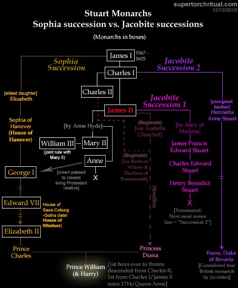
After the exit of Queen Elizabeth II, the line of succession will be:
Prince Charles
Prince William
Prince George (William's baby)
It just so happens that Pope Francis's real name is also "George". (Full name: Jorge Mario Bergoglio.) And George Michael just died on Christmas, the biggest Christian holiday mere days before New Year's Day.
Perhaps there is something special about Prince George? I talked extensively about the "Grail bloodline" symbolism surrounding the British royal family, particularly on the Diana side and Prince William, in my 2011 article "Lucifer's Destiny".
Perhaps this year (2017) the Pope and/or the Queen will die/exit which will trigger a chain reaction that leads to:
the FALL of the Roman Catholic Church
the RISE of the "Holy Grail" via British Royal Family after QE2
This duality would make a lot of multicontextual sense since the Holy Grail tradition has a lot - if not is all about - the Gnostic/Hermetic/Egyptian underground stream, the "religion" or philosophy (as well as bloodlines in some capacity) embodied in the figure of Isis, suppressed by the Roman Christianity which came into power via Constantin the Great. I'm not saying the bloodline of Princess Diana (Prince William, Prince George, etc.) has to be literally of the Holy Grail a la "The Da Vince Code", but even just a symbolic rise of "King Arthur" in this manner would be... well, symbolic of "Isis rising".
Isis is Sirius, and Sirius is "The Star", which is tarot card #17 as in 2017.
The Moon phase on Monday, June 21, 1982 is New Moon with an illumination of 0.61%. This indicates the percentage of the Moon illuminated by the Sun. On Monday, June 21, 1982, the Moon is 0.73 days old. This number shows how many days have passed since the last New Moon.
The Moon phase on Monday, June 21, 1982 is New Moon with an illumination of 0.61%. This indicates the percentage of the Moon illuminated by the Sun. On Monday, June 21, 1982, the Moon is 0.73 days old. This number shows how many days have passed since the last New Moon.
Sir Francis Drake, the famous Elizabethan explorer, did not have a direct connection to the Falkland Islands. While he circumnavigated the globe and explored various parts of South America, the Falkland Islands were not on his itinerary. He was known for his exploits as a privateer, fighting against the Spanish, and his circumnavigation voyage, which led to the naming of the Drake Passage between South America and Antarctica. The Falkland Islands, a British territory, were later settled in the 18th century and were not part of Drake's exploration or activities.
Sir Francis Drake (c. 1540 – 28 January 1596) was an English explorer and privateer best known for making the second circumnavigation of the world in a single expedition between 1577 and 1580 (being the first English expedition to accomplish this). Having started as a simple seaman, in 1588 he was part of the fight against the Spanish Armada as a vice-admiral.
At an early age, Drake was placed into the household of a relative, William Hawkins, a prominent sea captain in Plymouth. In 1572, he set sail on his first independent mission, privateering along the Spanish Main. Drake's circumnavigation began on 15 December 1577. He crossed the Pacific Ocean, until then an area of exclusive Spanish interest, and laid claim to New Albion, plundering coastal towns and ships for treasure and supplies as he went. He arrived back in England on 26 September 1580. Elizabeth I awarded Drake a knighthood in 1581 which he received aboard his galleon the Golden Hind.
Drake's circumnavigation inaugurated an era of conflict with the Spanish and in 1585, the Anglo-Spanish War began. Drake was in command of an expedition to the Americas that attacked Spanish shipping and ports. When Philip II sent the Spanish Armada to England in 1588 as a precursor to its invasion, Drake was second-in-command of the English fleet that fought against and repulsed the Spanish fleet. A year later he led the English Armada in a failed attempt to destroy the remaining Spanish fleet.
Drake was a Member of Parliament (MP) for three constituencies: Camelford in 1581, Bossiney in 1584, and Plymouth in 1593. Drake's exploits made him a hero to the English, but his privateering led the Spanish to brand him a pirate, known to them as El Draque ("The Dragon" in old Spanish).[1] He died of dysentery after his failed assault on Panama in January 1596.
Portrait miniature by Nicholas Hilliard, 1581, inscribed Aetatis suae 42, An(n)o D(omi)ni 1581 ("42 years of his age, 1581 AD")1583 portrait of Sir Francis Drake by Jodocus Hondius I
Francis Drake was born at Crowndale Farm in Tavistock, Devon, England.[4] His birth date is not formally recorded – such writers as E. F. Benson have claimed that he was born while the Six Articles of 1539 were in force,[5] but British naval historian Julian Corbett, writing of William Camden's account, on which this information is based, writes that "As a slip of memory, too, we must put down his difficult assertion that Edmund Drake was driven from Devonshire during a persecution under the Six Articles Act of 1539."[6] His birth date is estimated from the wording of texts in contemporary sources such as: "Drake was two and twenty when he obtained the command of the Judith"[7] (1566). This would date his birth to 1544. A date of c. 1540 is suggested from two portraits: one a miniature, painted by Nicholas Hilliard in 1581, when he was allegedly 42, which would place his birth c. 1539, while the other, painted in 1594 when he was said to be 52,[8] would give a birth year of c. 1541.
Due to religious persecution during the Prayer Book Rebellion in 1549, the Drake family fled from Devon to Kent. There Drake's father obtained an appointment to minister to the men in the King's Navy. He was ordained deacon and was made vicar of Upchurch Church on the Medway.[11]
At an early age, Drake was placed into the household of a relative, sea-captain William Hawkins of Plymouth, and began his seagoing training as an apprentice on Hawkins' boats.[12] By 18, he was a purser, according to the English chronicler Edmund Howes,[13] and in the 1550s, Drake's father found the young man a position with the owner and master of a small barque, one of the small traders plying between the Medway River and the Dutch coast. Drake likely engaged in commerce along the coast of England, the Low Countries and France.[14] The ship's master was so satisfied with the young Drake's conduct that, being unmarried and childless at his death, he bequeathed the barque to Drake.[15]
In 1562, the West African slave trade was a duopoly dominated by the Portuguese and the Spanish. Sir John Hawkins devised a plan to break into that trade, and enlisted the aid of colleagues and family to finance his first slave voyage. Drake was not part of that group of financiers,[16] though his presence as one of hundreds of seamen on Hawkins's first two slaving voyages has been assumed.[17] There is some anecdotal evidence to support Drake serving as a common seaman on the first two voyages, and good evidence of his presence for the last two of four slaving voyages made by Hawkins' ships between 1562 and 1569.[12][18][19]
In 1562, Hawkins sailed to the coast of the Sierra Leone, seized Portuguese slave ships, and sold the Africans in the Spanish Indies.[20] It was highly profitable, so for his second slave voyage in 1564, Hawkins gained Queen Elizabeth I's support. She lent him one of her ships, Jesus of Lübeck, which served as his flagship.[21] Hawkins attacked an African native town and sold many of its inhabitants in Spanish ports on the Caribbean mainland, making another large profit for himself, the Queen and the consortium of investors from her court.[17][20] Sources vary on the dates and the age of Drake at the time;[22] Harry Kelsey says he was twenty years old, "[a]ccording to Howes" (in reference to the English chronicler Edmund Howes writing in 1615).[23] Drake was not a member of that consortium, but the crew would have received a small share of the profits.[24][25] Based on this association, scholar Kris Lane lists Drake as one of the first English slave traders.[26]
The Spanish and Portuguese were aggrieved that the English had entered into the slave trade and were selling slaves to their colonies despite being forbidden from doing so. Queen Elizabeth I, under pressure to avoid an armed conflict, forbade Hawkins from going to sea for a third slave voyage. In response, he set up a slave voyage with a relative, John Lovell, in command in 1566.[17] Drake accompanied Lovell on this voyage.[17] The voyage was unsuccessful, as more than 90 enslaved Africans were released without payment.[27]
In 1567, Drake accompanied Hawkins on their next and last joint voyage.[28] The crew attempted to capture slaves around Cape Verde, but failed. Hawkins allied himself with two local kings in Sierra Leone who asked for help against their enemies in exchange for half of any captives they took. Attacking from both sides, they took several hundred prisoners, though Kelsey says the kings kept "the larger share of slaves and dared Hawkins to do anything about it".[29]
Events worsened for the fleet as it faced storms, Spanish hostility, armed conflict, and finally a hurricane that separated one ship from the rest, and it had to find its own way home.[30] The remaining ships were forced into the port of San Juan de Ulúa near Vera Cruz so they could make repairs. Soon afterward the newly appointed viceroy of New Spain, Martín Enríquez de Almanza, arrived with a fleet of ships. While still negotiating to resupply and repair, Hawkins' ships were attacked by the Spanish ships in what became known as the Battle of San Juan de Ulúa.[31] The battle ended in an English defeat with all but two of the English ships lost. The Spanish launched a fireship against Hawkins' flagship Jesus of Lübeck, and the crew of Minion in panic and fear cut the lines securing them to Jesus. Hawkins was among those who jumped from the flagship's bulwarks to Minion's decks.[32] Drake, by this time the captain of Judith, fled leaving Hawkins behind. Hawkins escaped on Minion and limped back to England with dozens of his men dying along the way,[33] and arriving with a crew of just 15.[34] Hundreds of English seamen were abandoned.[35]
After arriving back in England, Hawkins accused Drake of desertion and of stealing the treasure they had accumulated. Drake denied both accusations asserting he had distributed all profits among the crew and that he had believed Hawkins was lost when he left.[25][36] The bitter end of the fourth voyage turned Drake's life in a different direction: thereafter he would not pursue trading and slaving but would, instead, dedicate himself to attacking Spanish possessions wherever he found them.[37] Drake's hostility towards the Spanish is said to have started with the battle and its aftermath.[38]
The voyage of 1567–1569 was Drake's last association with slaving. In total, approximately 1,200 Africans were enslaved on these four voyages,[39] and an estimated three times as many Africans were killed (based on the contemporaneous accounts of slavers).[19] On the issue of slaving, scholar John Sugden writes that "Drake was in his twenties and did not question what his elders accepted", but must share some culpability for his participation.[40]
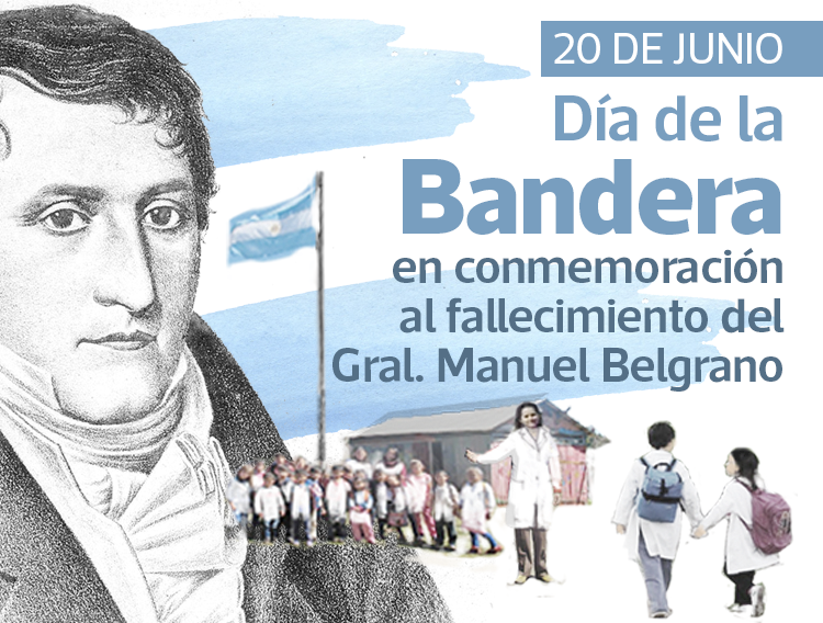
On 2 April 1982, Argentina invaded and occupied the Falkland Islands. It was the beginning of a ten-week conflict that ended with the Argentines surrendering on 14 June and the islands returning back to British control.
2022 marks 40 years since the conflict and the audacious Operation Black Buck raids carried out by the RAF. Operation Black Buck consisted of seven missions that are now legendary. The missions were flown using a fleet of V-force aircraft – Avro Vulcans and Handley Page Victors – and contributed to regaining the islands which had been a British territory since 1833.
The Falkland Islands have over 500 years of complex history. Early sightings of the islands were reported to forewarn sailors in a treacherous part of the world’s oceans and to map the New World. European mapmakers were keen to draw accurate charts for explorers and sought information from returning sailors.
Over the centuries, long before the age of jet technology, the islands were claimed by the French, Spanish, British and Argentines. Today the islands are officially designated the Falkland Islands in all United Nations documentation, but in its early years a number of names were applied to the area.
In 1493, Pope Alexander VI issued the papal bull (a type of public decree), Inter Caetera. He decreed that New World lands outside of Europe, which were not already held by a Christian Prince, to be divided between Spain and Portugal. The Treaty of Tordesillas was made the following year between the two countries and agreed that the dividing line between the two should be changed 370 leagues west of the Cape Verde Islands. The Falkland Islands lie on the western side of the line and would come under Spanish sovereignty, although they had not been discovered at that time.
Modern day map showing the lines dividing world between Spain and Portugal.
The other European powers had not signed the treaty and generally ignored it. By the early 1500s other European nations had rejected the idea that the Pope had the right to decide sovereignty of the New World. The validity of the Inter Caetera had been overwhelmingly denounced, even by influential people within Spain.
In 1580, the Spanish Ambassador complained about English ships in Spanish seas and made a demand for satisfaction from Queen Elizabeth I. The complaint was in reaction to Francis Drake’s circumnavigation of the globe. The response from the Queen was:
“Her Majesty does not understand why her subjects and those of other Princes are prohibited from the Indies, which she could not persuade herself are the rightful property of Spain by donation of the Pope of Rome . . . and that only on the ground that Spaniards have touched here and there, have erected shelters, have given names to a river or promontory; acts which cannot confer property. So that this donation of alien property (which be essence of law is void) and this imaginary proprietorship ought not to hinder other princes from carrying on commerce in these regions, and from establishing Colonies where Spaniards are not residing, without the least violation of the law of nations.”
She continued:
“…every nation had a right by the law of nature to freely navigate those seas and transport colonies to those parts where the Spaniards do not inhabit.”
English Ships and the Spanish Armada, August 1588
In 1588, Spain sent an Armada to invade Britain. Their aim was to overthrow Queen Elizabeth I and her establishment of Protestantism in England, to stop English interference in the Spanish Netherlands, and to stop the harm caused by English and Dutch privateering ships that disrupted Spanish interests in the Americas. The attempt was thwarted by the professionalism of the Royal Navy, good naval battle tactics and bad weather.
Flag of the Falkland Islands
In August 1592 English Captain, John Davis, made the first recorded sighting of the Falkland Islands. During a storm, Davis’ ship, the Desire, was fortunately blown amongst the islands, which provided shelter from the winds and storm.
In recognition of the sighting, the 14 August is known as Falklands Day in the islands and the Falkland’s Coat of Arms includes an image of Davis’ ship and incorporates the motto – Desire the Right – which is a reference to the ship’s name. The ship and motto have been included on Coats of Arms displayed on the Flag of the Falklands, since 1925.
John Davis, who was a master navigator, also invented a navigational instrument – the backstaff and double quadrant – which measures the altitude of the sun by the projection of a shadow.
Backstaff Davis Quadrant
On 2 February 1594, while repeating Francis Drake’s 1577 Voyage of Discovery, Britain’s Richard Hawkins sighted an uncharted land and named it Hawkins Maiden Land. In a publication of The Observations of Sir Richard Hawkins in his Voyage into the South Sea, Hawkins describes the sighting:
“… about nine of the clocke in the morning, wee descried land, which bare South-West of us, which we looked not for so timely and coming neerer and neerer unto it, by the lying, wee could not conjecture what land it could be…. It hath great Rivers of fresh waters; for the out-shoot of them colours the Sea … The Land, for that it was discovered in the Reigne of Queene Elizabeth, my Sovereigne Lady and Mistris, and a Mayden Queene, and at my cost and adventure, in a perpetual memory of her chastitie, and remembrance of my endevours, I gave it the name of Hawkins Maiden land … the Westernmost part lyeth some threescore leagues from the neerest Land of America.”
By the 17th century it was clear that an uninhabited archipelago, which has land mass about the size of Yorkshire, lay off the coast of South America.
In January 1600, the islands were named Sebald Islands by Sebald de Weert. On his journey home to the Netherlands after an expedition to the East Indies via the Straits of Magellan, de Weert noticed some islands that did not exist on his nautical charts. He was unable to land due to harsh conditions and continued on his journey, naming the islands the Sebald de Weert Islands.
(L) Illustration by William Hacke, one of the most prolific manuscript chart makers for his time, in 1699.
(R) Pepys Island depicted on an 18th-century map.
In December 1683, while circumnavigating the globe on the Bachelor’s Delight, the British Bucaneer, William Ambrose Cowley, discovered what he believed was an uncharted island in the South Atlantic which he named Pepys Island, named after Samuel Pepys, Secretary to the Admiralty. Cowley’s companion on the voyage, William Dampier, considered the sighting to be the Sebald Islands, the alternative name at that time for the Falklands. Dampier was correct, Pepys Island was a phantom island. However, the mention of a discovery of this new island prompted a number of voyages to the mythical land.
In 1690, English captain John Strong, made the first recorded landing on the islands. Strong was on an expedition from London to South America between 1689-1691. Commanding HMS Welfare, he explored the strait that separates the two main islands. Strong named the channel Falkland Sound, in honour of the man who sponsored his journey – Anthony Cary, 5th Viscount of Falkland.
HMS Dolphin at Tahiti 1767
Between June 1764 and May 1766, British captain John Byron was on a discovery expedition with the Royal Navy vessel HMS Dolphin. This was Dolphin’s first circumnavigation of the globe. She would eventually become the first ship to circumnavigate the world twice. The mission was to seek new trade markets and claim any undiscovered or unclaimed lands for the British. A search for Pepys Island was part of the voyage. After searching in vain for the phantom island Byron eventually reached the northwest tip of West Falkland in January 1965.
On describing the port and naming it Port Egmont, in Byron’s Journal of his Circumnavigation, 1764-1766, he wrote:
“Port Egmont (which I so named after the Earl of Egmont) I think it without exception one of the finest Harbours I ever saw in my life.”
Byron went on to claim the islands for King George III and wrote:
“I took Possession of this Harbour & all these islands for His Majesty King George the Third / of Great Britain & His Heirs, tho’ they had been before taken Possession of by Sr Richd Hawkins in the Year 1593” [actually in 1594]
Unbeknown to Byron there was French settlement on the East Falkland. French explorer Louis-Antoine de Bougainville had colonised the island in 1763. He named the area Iles Malouines, which was named after the point of departure for his ships and colonists – the port of Saint-Malo in Brittany, western France.
In 1766 France agreed to leave the island after Spain complained about the French presence in areas that were considered Spanish territories. The agreement was based on the alliance between the Bourbon kings of France and Spain – the Pacte de Famille. The Spanish name for the archipelago is Islas Malvinas, which is a translation of the French name of Iles Malouines.
The Spanish were aware of the British presence on the islands when their close ally France handed back East Falkland. On 28 November 1769, Captain Anthony Hunt observed a Spanish vessel surveying the western island. The commander of the vessel was sent a message requiring him to depart. In 1770, the Spanish authorities in Buenos Aires began issuing warnings to the British on West Falkland to leave what they considered their territory. The British also issued warnings, to the Spanish, for them to leave the British territory. In June 1770, the Spanish surprised the British settlement and captured Port Egmont. The British were evicted and allowed to set sail for England.
The incident, known as the Falklands Crisis of 1770, nearly led to war. The matter was addressed to the court of Madrid by the British. During the court discussions the question of sovereignty was evaded, with neither nation relinquishing its claim over the islands. Eventually, when France refused to back Spain, the Spanish court backed down and an agreement was made to disavow the actions of Buenos Aires and restore Port Egmont as it existed before being captured. The British agreed that they would disavow the conduct of Captain Hunt, who ordered the Spanish away from East Falkland.
The plaque placed at Port Egmont, Saunders Island to commemorate the first British colony on the Falkland Islands.
British and Spanish settlements coexisted on the islands until 1774, when Britain’s economic pressures led to a withdrawal from many overseas settlements. On leaving the Falkland Islands Britain left a plaque that claimed continuing sovereignty. During the period that followed a number of countries laid claim to the British territory, including Spain, which never gave up its claims to the Falkland Islands based on the Pope’s papal bulls.
Between 1810 and 1818 The Argentine War of Independence was fought. During this war, in 1816, Argentina declared independence. Prior to then the territory was part of the Spanish Empire. The Argentines claim to the Falkland Islands is based on inheriting them from Spain when sovereignty passed to Argentina.
Since the Falkland Islands had no inhabitants at the time, in 1823 Buenos Aires granted land to Luis Vernet. Vernet had also requested permission from the British Consulate in Buenos Aires and agreed to provide regular reports when they gave their consent. Later, Buenos Aires proclaimed him governor of the islands which the British protested restating their claim to the islands.
In December 1831, British naval officer, Robert Fitzroy, commanded the voyage of HMS Beagle which sailed around the world with Charles Darwin aboard. While at the Falkland Islands, Darwin studied the relationships of species to habitats. During the exploration he found ancient fossils like those he had found in Wales in the summer of 1831. When organising his notes as the ship sailed home, Darwin wrote that, if his growing suspicions about the mockingbirds, the tortoises and the Falkland Islands fox were correct then such facts;
“seemed to me to throw some light on the origin of species.”
The voyage provided Charles Darwin with much of the material on which he based his theory of evolution.
HMS Beagle in the Straits of Magellan, image from Charles Darwin’s 1890 illustrated edition of The Voyage of the Beagle.
Captain Robert Fitzroy was not only the commander of the voyage, but also a scientist. He was a pioneering meteorologist who went on to make accurate daily weather predictions. In 1854 he established what we now know as the Met Office. Daily weather data was collected at 9am from set locations around the UK coast. These Daily Weather Reports assisted FitzRoy in developing charts that allowed predictions to be made which he called a weather forecast.
The data is still collected today and they form the longest continuous series of data in the National Meteorological Archive. The full series of reports is available from their Digital Library & Archive.
In December 1832, Britain returned to West Falkland. The first actions of Captain John Onslow and the crew of HMS Clio were to repair the fort at Port Egmont and affix a notice of possession. The Clio was later joined by HMS Tyne. On 2 January 1833, Onslow arrived at the east island and the Spanish settlement on East Falkland was asked to leave and replace the Argentine flag with the British flag.
“I have to direct you that I have received directions from His Excellency and Commander-in-Chief of His Britannic Majesty’s ships and vessels of war, South America station, in the name of His Britannic Majesty, to exercise the rights of sovereignty over these Islands. It is my intention to hoist to-morrow the national flag of Great Britain on shore when I request you will be pleased to haul down your flag on shore and withdraw your force, taking all stores belonging to your Government.”
Written request presented to Argentine officer – 2 January 1833
British forces disembarked on 3 January 1833 and switched the flags. British sovereignty of the islands was reasserted and Britain has held the territory ever since, apart from a 74 day period in 1982. It is the proud British history associated with the Falklands that led to Britain’s resolve to take back the islands when Argentina invaded on 2 April 1982.
El 2 de abril de 1982, Argentina invadió y ocupó las Islas Malvinas. Fue el comienzo de un conflicto de diez semanas que culminó con la rendición argentina el 14 de junio y el regreso de las islas a control británico.
En 2022 se cumplen 40 años del conflicto y de las audaces incursiones de la Operación Black Buck, llevadas a cabo por la RAF. Esta operación consistió en siete misiones que ahora son legendarias. Las misiones se realizaron con una flota de aviones de la Fuerza V (Avro Vulcan y Handley Page Victor) y contribuyeron a la recuperación de las islas, que habían sido territorio británico desde 1833.
Las Islas Malvinas tienen más de 500 años de compleja historia. Se reportaron avistamientos tempranos de las islas para advertir a los navegantes en una zona peligrosa de los océanos y para cartografiar el Nuevo Mundo. Los cartógrafos europeos se esmeraban en dibujar cartas precisas para los exploradores y buscaban información de los navegantes que regresaban.
A lo largo de los siglos, mucho antes de la era de la tecnología de los aviones a reacción, las islas fueron reclamadas por franceses, españoles, británicos y argentinos. Hoy en día, se denominan oficialmente Islas Malvinas. en toda la documentación de las Naciones Unidas, pero en sus inicios se le aplicaron diversos nombres a la zona.
En 1493, el papa Alejandro VI emitió la bula papal (un tipo de decreto público) Inter Caetera. Decretó que las tierras del Nuevo Mundo fuera de Europa, que no estuvieran ya en posesión de un príncipe cristiano, se dividirían entre España y Portugal. El Tratado de Tordesillas se firmó al año siguiente entre ambos países, y acordó que la línea divisoria entre ambos se desplazaría 370 leguas al oeste de las islas de Cabo Verde. Las Islas Malvinas se encuentran al oeste de la línea y quedarían bajo soberanía española, aunque aún no habían sido descubiertas.
Mapa moderno que muestra las líneas que dividen el mundo entre España y Portugal.
Las demás potencias europeas no habían firmado el tratado y, en general, lo ignoraron. A principios del siglo XVI, otras naciones europeas habían rechazado la idea de que el Papa tuviera el derecho a decidir sobre la soberanía del Nuevo Mundo. La validez del Inter Caetera había sido denunciada abrumadoramente, incluso por figuras influyentes de España.
En 1580, el embajador español se quejó de la presencia de barcos ingleses en mares españoles y exigió una reparación a la reina Isabel I. La queja se originó en reacción a la circunnavegación del globo de Francis Drake. La respuesta de la reina fue:
Su Majestad no comprende por qué a sus súbditos y a los de otros príncipes se les prohíbe la entrada a las Indias, de las que no pudo convencerse a sí misma de que son legítima propiedad de España por donación del Papa de Roma... y esto solo porque los españoles han tocado aquí y allá, han erigido refugios, han dado nombre a un río o promontorio; actos que no pueden conferir propiedad. De modo que esta donación de propiedad extranjera (cuya esencia jurídica es nula) y esta propiedad imaginaria no deberían impedir que otros príncipes comercien en estas regiones ni establezcan colonias donde no residan españoles, sin la menor violación del derecho de gentes.
Ella continuó:
“…toda nación tenía derecho, por ley natural, a navegar libremente por esos mares y transportar colonias a aquellas partes donde no habitaban los españoles.”
Barcos ingleses y la Armada Española, agosto de 1588
En 1588, España envió una Armada para invadir Gran Bretaña. Su objetivo era derrocar a la reina Isabel I y su instauración del protestantismo en Inglaterra, frenar la intromisión inglesa en los Países Bajos españoles y frenar los daños causados por los barcos corsarios ingleses y holandeses que perturbaban los intereses españoles en América. El intento se vio frustrado por la profesionalidad de la Marina Real Británica, las buenas tácticas de combate naval y el mal tiempo.
Bandera de las Islas Malvinas
En agosto de 1592, el capitán inglés John Davis realizó el primer avistamiento registrado de las Islas Malvinas. Durante una tormenta, el barco de Davis, el Desire, fue arrastrado entre las islas, lo que le brindó refugio de los vientos y la tormenta.
En reconocimiento al avistamiento, el 14 de agosto se conoce como el Día de las Malvinas en las islas, y el escudo de armas de las Malvinas incluye una imagen del barco de Davis e incorpora el lema «Desire the Right», que hace referencia al nombre del barco. El barco y el lema han figurado en los escudos de armas que ondean en la bandera de las Malvinas desde 1925.
John Davis, que fue un maestro navegante, también inventó un instrumento de navegación: el mástil y el doble cuadrante , que mide la altitud del sol mediante la proyección de una sombra.
Cuadrante Davis del personal de apoyo
El 2 de febrero de 1594, mientras repetía el viaje de descubrimiento de Francis Drake de 1577, el británico Richard Hawkins avistó una tierra inexplorada y la bautizó como Tierra de la Doncella de Hawkins. En una publicación de " Las observaciones de Sir Richard Hawkins en su viaje al Mar del Sur" , Hawkins describe el avistamiento:
Alrededor de las nueve de la mañana, avistamos tierra al suroeste de nosotros, la cual no esperábamos tan oportunamente, y acercándonos cada vez más, por la inclinación, no podíamos conjeturar qué tierra podría ser… Tiene grandes ríos de agua dulce; pues sus desembocaduras colorean el mar… La tierra, pues fue descubierta durante el reinado de la reina Isabel, mi Soberana Señora y Señora, y una Reina María, y a mi costa y aventura, en perpetua memoria de su castidad y recuerdo de mis esfuerzos, le di el nombre de Tierra de la Doncella de Hawkins… la parte más occidental se encuentra a unas sesenta leguas de la tierra más cercana de América.
En el siglo XVII quedó claro que frente a las costas de América del Sur se encontraba un archipiélago deshabitado, con una superficie de tierra aproximadamente del tamaño de Yorkshire.
En enero de 1600, Sebald de Weert bautizó las islas como Islas Sebald. Durante su viaje de regreso a los Países Bajos, tras una expedición a las Indias Orientales por el Estrecho de Magallanes, de Weert observó algunas islas que no figuraban en sus cartas náuticas. No pudo desembarcar debido a las duras condiciones y continuó su viaje, bautizándolas como Islas Sebald de Weert.
(L) Ilustración de William Hacke, uno de los creadores de gráficos manuscritos más prolíficos de su época , en 1699.
(R) Isla Pepys representada en un mapa del siglo XVIII.
En diciembre de 1683, mientras circunnavegaba el mundo a bordo del Bachelor's Delight, el bucanero británico William Ambrose Cowley descubrió lo que creía una isla inexplorada en el Atlántico Sur, a la que bautizó como Isla Pepys, en honor a Samuel Pepys, secretario del Almirantazgo. El compañero de viaje de Cowley, William Dampier, consideró que el avistamiento correspondía a las Islas Sebald, el nombre alternativo que se daba entonces a las Malvinas. Dampier tenía razón: la Isla Pepys era una isla fantasma. Sin embargo, la mención del descubrimiento de esta nueva isla impulsó numerosos viajes a la mítica tierra.
En 1690, el capitán inglés John Strong realizó el primer desembarco registrado en las islas. Strong participó en una expedición de Londres a Sudamérica entre 1689 y 1691. Al mando del HMS Welfare, exploró el estrecho que separa las dos islas principales. Strong bautizó el canal como Falkland Sound en honor al hombre que patrocinó su viaje: Anthony Cary, quinto vizconde de Falkland.
HMS Dolphin en Tahití 1767
Entre junio de 1764 y mayo de 1766, el capitán británico John Byron participó en una expedición de descubrimiento con el HMS Dolphin, un buque de la Marina Real Británica. Esta fue la primera circunnavegación del mundo del Dolphin. Con el tiempo, se convertiría en el primer barco en circunnavegar el mundo dos veces. La misión consistía en buscar nuevos mercados comerciales y reclamar para los británicos cualquier territorio no descubierto o reclamado. La búsqueda de la isla Pepys formaba parte del viaje. Tras buscar en vano la isla fantasma, el Byron finalmente llegó al extremo noroeste de la Malvina Occidental en enero de 1965.
Al describir el puerto y nombrarlo Puerto Egmont, en el Diario de su circunnavegación, 1764-1766, Byron escribió:
“Puerto Egmont (al que bauticé en honor al conde de Egmont) es, sin excepción, uno de los puertos más hermosos que he visto en mi vida”.
Byron continuó reclamando las islas para el rey Jorge III y escribió:
“Tomé posesión de este puerto y de todas estas islas para Su Majestad el Rey Jorge III de Gran Bretaña y sus herederos, aunque ya habían sido tomadas en posesión por el Sr. Richard Hawkins en el año 1593” [en realidad, en 1594].
Byron desconocía la existencia de un asentamiento francés en la isla Malvina Oriental. El explorador francés Louis-Antoine de Bougainville había colonizado la isla en 1763. Bautizó la zona como Îles Malouines, nombre que debía su nombre al punto de partida de sus barcos y colonos: el puerto de Saint-Malo en Bretaña, al oeste de Francia.
En 1766, Francia accedió a abandonar la isla tras las quejas de España por la presencia francesa en zonas consideradas territorio español. El acuerdo se basó en la alianza entre los reyes Borbones de Francia y España: el Pacto de Familia. El nombre español del archipiélago es Islas Malvinas, traducción del francés Iles Malouines.
Los españoles estaban al tanto de la presencia británica en las islas cuando Francia, su aliado cercano, les devolvió la Malvina Oriental. El 28 de noviembre de 1769, el capitán Anthony Hunt observó un buque español que inspeccionaba la isla occidental. El comandante del buque recibió un mensaje exigiéndole que partiera. En 1770, las autoridades españolas en Buenos Aires comenzaron a advertir a los británicos en la Malvina Occidental para que abandonaran lo que consideraban su territorio. Los británicos también advirtieron a los españoles para que abandonaran el territorio británico. En junio de 1770, los españoles sorprendieron al asentamiento británico y capturaron Puerto Egmont. Los británicos fueron desalojados y se les permitió zarpar hacia Inglaterra.
El incidente, conocido como la Crisis de las Malvinas de 1770, casi desembocó en una guerra. Los británicos llevaron el asunto a la corte de Madrid. Durante las discusiones judiciales, se eludió la cuestión de la soberanía, y ninguna nación renunció a su reclamación sobre las islas. Finalmente, cuando Francia se negó a respaldar a España, la corte española cedió y se llegó a un acuerdo para repudiar las acciones de Buenos Aires y restaurar Puerto Egmont tal como existía antes de su captura. Los británicos acordaron repudiar la conducta del capitán Hunt, quien ordenó a los españoles abandonar las Islas Malvinas Orientales.
La placa colocada en Puerto Egmont, Isla Saunders, para conmemorar la primera colonia británica en las Islas Malvinas.
Los asentamientos británicos y españoles coexistieron en las islas hasta 1774, cuando las presiones económicas británicas provocaron la retirada de muchos asentamientos de ultramar. Al abandonar las Islas Malvinas, Gran Bretaña dejó una placa que reclamaba la soberanía permanente. Durante el período posterior, varios países reclamaron el territorio británico, incluida España, que nunca renunció a sus derechos sobre las Islas Malvinas basándose en las bulas papales.
Entre 1810 y 1818 se libró la Guerra de la Independencia Argentina. Durante esta guerra, en 1816, Argentina declaró su independencia. Anteriormente, el territorio formaba parte del Imperio español. El reclamo argentino sobre las Islas Malvinas se basa en haberlas heredado de España cuando la soberanía pasó a Argentina.
Dado que las Islas Malvinas no estaban habitadas en ese momento, en 1823 Buenos Aires otorgó tierras a Luis Vernet. Vernet también había solicitado permiso al Consulado Británico en Buenos Aires y se comprometió a presentar informes periódicos cuando este diera su consentimiento. Posteriormente, Buenos Aires lo proclamó gobernador de las islas, ante lo cual los británicos protestaron, reafirmando su derecho sobre las islas.
En diciembre de 1831, el oficial naval británico Robert Fitzroy comandó el viaje del HMS Beagle, que dio la vuelta al mundo con Charles Darwin a bordo. Durante su estancia en las Islas Malvinas, Darwin estudió la relación entre las especies y los hábitats. Durante la exploración, halló fósiles antiguos similares a los que había hallado en Gales en el verano de 1831. Al organizar sus notas mientras el barco regresaba a casa, Darwin escribió que, si sus crecientes sospechas sobre los sinsontes, las tortugas y el zorro de las Islas Malvinas eran correctas, entonces tales hechos...
“Me pareció que arrojaba algo de luz sobre el origen de las especies”.
El viaje proporcionó a Charles Darwin gran parte del material en el que basó su teoría de la evolución.
HMS Beagle en el Estrecho de Magallanes, imagen de la edición ilustrada de 1890 de El viaje del Beagle de Charles Darwin.
El capitán Robert Fitzroy no solo fue el comandante del viaje, sino también un científico. Fue un meteorólogo pionero que realizó predicciones meteorológicas diarias precisas. En 1854, fundó lo que hoy conocemos como el Servicio Meteorológico. Los datos meteorológicos diarios se recopilaban a las 9:00 de la mañana desde puntos determinados de la costa del Reino Unido. Estos informes meteorológicos diarios ayudaron a FitzRoy a desarrollar cartas que permitían realizar predicciones, a las que él llamó pronóstico del tiempo .
Los datos se siguen recopilando hoy en día y constituyen la serie continua más larga del Archivo Meteorológico Nacional. La serie completa de informes está disponible en su Biblioteca y Archivo Digital.
En diciembre de 1832, Gran Bretaña regresó a las Islas Malvinas Occidentales. Las primeras acciones del capitán John Onslow y la tripulación del HMS Clio fueron reparar el fuerte de Puerto Egmont y colocar un aviso de posesión. Posteriormente, el HMS Tyne se unió al Clio. El 2 de enero de 1833, el Onslow llegó a la isla este y se solicitó al asentamiento español en las Islas Malvinas Orientales que abandonara la isla y reemplazara la bandera argentina por la británica.
Debo informarle que he recibido instrucciones de Su Excelencia y Comandante en Jefe de los buques y navíos de guerra de Su Majestad Británica, en la estación Sudamérica, en nombre de Su Majestad Británica, para ejercer los derechos de soberanía sobre estas islas. Tengo la intención de izar mañana la bandera nacional de Gran Bretaña en tierra, cuando le solicito que tenga a bien arriar su bandera y retirar sus fuerzas, llevándose todos los pertrechos de su Gobierno.
Solicitud escrita presentada a oficial argentino – 2 de enero de 1833
Las fuerzas británicas desembarcaron el 3 de enero de 1833 y cambiaron las banderas. Se reafirmó la soberanía británica sobre las islas y Gran Bretaña ha mantenido el territorio desde entonces, salvo por un período de 74 días en 1982. Es la orgullosa historia británica asociada con las Malvinas la que motivó a Gran Bretaña a tomar la decisión de recuperar las islas cuando Argentina las invadió el 2 de abril de 1982.
The celebrity association with August 14th and the Falkland Islands is Captain John Davis, who made the first recorded sighting of the islands on that day in 1592. This date is commemorated as Falklands Day. Additionally, the islands are named after the "Desire", the ship on which Davis made the sighting, and the flag and motto reflect this.
John Davis, on board his 120 ton vessel 'Desire', the first sighting of the Falklands
The plaque dedicated to the explorer John Davis at his home in SandridgeThe Falkland Islands coat of arms with the motto “Desire the Right”
14 August is Falklands Day and commemorates the first sighting of the Falkland Islands on that day in 1592 by the English navigator and explorer, John Davis, on board his 120-ton vessel 'Desire'. Davis (1550-1605) was one of the principal navigators under Queen Elizabeth I.
He came across the uninhabited islands of the Falklands, having been blown off course on an attempt to round Cape Horn through the Straits of Magellan. His account of this voyage was published in 1600 by Richard Hakluyt of London. Davis was born in Sandridge, Devon and owned a small house on the harbor shore of Plymouth, commemorated by the City Council with a blue plaque.
Davis' sighting was followed by those of Sir Richard Hawkins in 1594 and of the Dutch explorer, Sebald de Weert, in January 1600. But the first recorded landing was not until 1690, when the English sea captain, John Strong, came ashore at Bold Cove near Port Howard from his ship 'Welfare'. Strong gave the name Falkland Sound to the passage between East and West Falklands after Viscount Falkland, then First Lord of the Admiralty, who also happened to be one of the owners of Welfare.
The Falkland Islands derive their name from the Falkland Sound, and Davis' ship 'Desire' is featured prominently on the Falkland Islands coat of arms and in the motto: 'Desire the Right'.
The Falkland Islands never had any native inhabitants and were entirely unoccupied until 1765, when they were first claimed by the British who established a garrison at Port Egmont. Over the years, the British, French and Spanish periodically had garrisons within the Islands until 1811 when all were withdrawn.
On 6 October 1832, an Argentine military garrison arrived in an attempt to establish sovereignty over the Falkland Islands, disregarding the British claim of 67 years prior. Less than three months later, on 2 January 1833, the Royal Navy evicted the military base with no loss of life. The civilian population, who had sought permission from Britain to live there, were invited to stay. A year later, a small, permanent British administration was established and in 1845 Stanley become the capital.
Sheep farming became the main industry of the Falklands which enjoyed a peaceful existence until 1 April 1982, when an Argentine military force invaded the Islands. Seventy four days of foreign occupation ended with Liberation by British forces on 14 June 1982. Nearly 1,000 Falkland Islands, British and Argentine lives were lost as a result of the war.
Since 1982, lives in the Falklands have been transformed: the Islands have become financially self-sufficient (fishing industry and tourism), a democracy entirely self-governing, except for defense and foreign affairs. The community has been formed through voluntary immigration and settlement over the course of nearly two hundred years. It is a diverse multicultural society, with people from over 60 nations having made the Islands their home. At the heart are those Falkland Islanders whose families have been in the Islands for nine generations.
In 2009 a new Constitution confirmed enhanced local democracy, internal self-government and enshrined, following on the UN charter, the Falklands' people right of self-determination and to decide on their future. Four years later in 2013, a referendum was held, which was overseen by international observers, when 99.8% of the electorate voted to remain a British Overseas Territory.
On Friday 20 May 2022, Stanley – capital of the Falkland Islands – was granted official city status by Her Majesty Queen Elizabeth II, as part of Platinum Jubilee celebrations.
August 14th marks the first sighting of the Falkland Islands by British explorer John Davis in 1592. We wish everyone a happy Falklands Day and we will continue to celebrate these Islands that many have made their home.
Stanley (also known as Port Stanley) is the capital city of the Falkland Islands. It is located on the island of East Falkland, on a north-facing slope in one of the wettest parts of the islands. At the 2016 census, the city had a population of 2,460.[1] The entire population of the Falkland Islands was 3,398 on Census Day – 9 October 2016.
The town hall serves as a post office, philatelic bureau, law court, and dance hall. The police station also contains the islands' only prison, with capacity for 13 inmates.
The community centre includes a swimming pool (the only public one in the islands), a sports centre, and school. A grass football pitch is located by the community centre. A separate building houses the college of further education and the library. A new sports centre is under construction to the south of the town centre, next to a newly-laid floodlit all-weather pitch.
Stanley Racecourse, located on the west side of Stanley, holds a two-day horse racing meeting every year on 26 and 27 December. The Christmas races have been held here for over 100 years.
Stanley Golf Course has an 18-hole course and a club house. It is also located to the west of Stanley.
King Edward VII Memorial Hospital is the islands' main hospital, with doctors' practice and surgery, radiology department, dental surgery and emergency facilities.
The original capital of the islands was at Port Louis to the north of the present site of Stanley, on Berkeley Sound. Captains Francis Crozier and James Clark Ross were recruited by Governor Richard Moody in his quest to find a new capital for The Falklands. Both Crozier and Ross (who are remembered in Crozier Place and Ross Road in Stanley) were among the Royal Navy's most distinguished seafarers. They spent five months in the islands with their ships Terror and Erebus, later lost looking for the Northwest Passage. Governor Moody (after whom Moody Brook is named), however, decided to move the capital to Port Jackson, which was renamed "Stanley Harbour", after a survey. Stanley Harbour was considered to have a deeper anchorage for visiting ships. Not all the inhabitants were happy with the change; a JW Whitington is recorded as saying, "Of all the miserable bog holes, I believe that Mr Moody has selected one of the worst for the site of his town."[3]
Work on the settlement began in 1843 and it became the capital in July 1845. It was named after Lord Stanley, Secretary of State for War and the Colonies at the time. In 1849, 30 married Chelsea Pensioners were settled there to help with the defence of the islands and to develop the new settlement.
The settlement soon grew as a deep-water port, specialising at first in ship repairs; before the construction of the Panama Canal, Port Stanley was a major repair stop for ships travelling through the Straits of Magellan. The rough waters and intense storms found at the tip of the continent forced many ships to Stanley Harbour, and the ship repair industry helped to drive the island economy. Later it became a base for whaling and sealing in the South Atlantic and Antarctic.
Landslides caused by excessive peat cutting destroyed part of the town in 1879 and again in 1886, which killed two people. At about midnight on 29 November 1878 a black moving mass, several feet high, was moving forwards at a rate of 4 miles per hour (6.4 km/h) or 5 miles per hour (8.0 km/h). The next morning the town was cut in two; the only way to travel between the two parts was by boat.[4]
Stanley Airport is used by internal flights and provides connections to British bases in Antarctica. Flights to Argentina ended after the 1982 conflict. A weekly flight to Punta Arenas in Chile commenced in 1993, which now operates out of RAF Mount Pleasant. Scheduled passenger flights between the Mount Pleasant airfield and the UK are also operated twice a week by a civilian airline contractor on behalf of the Royal Air Force.
Stanley was occupied by Argentine troops for about 10 weeks during the Falklands War in 1982. The Argentinians renamed the town Puerto Argentino, and although Spanish names for places in the Falklands were historically accepted as alternatives, this one is considered to be extremely offensive by many islanders.[6] Stanley suffered considerable damage during the war, from both the Argentine occupation and the British naval shelling of the town, which killed three civilians. After the British secured the high ground around the town the Argentines surrendered with no fighting in the town itself. The beaches and land around it were heavily mined and some areas remain marked minefields.
Since the Falklands War, Stanley has benefited from the growth of the fishing and tourism industries in the Islands. Stanley itself has developed greatly in that time, with the building of a large amount of residential housing, particularly to the east of the town centre. Stanley is now more than a third bigger than it was in 1982.
A number of variants of the city's name have appeared in both English and Spanish. Stanley Harbour was originally known as "Port Jackson", and this name would have applied to the area before the town was built. Although the town is officially known as "Stanley", it is frequently referred to as "Port Stanley", especially in British reports about the Falklands War. This is in line with various other settlements around the islands, e.g. Port Howard and Port Stephens. However, "Stanley" without the "Port" prefix was established long before the war, and on 2 August 1956, the Officer Administering the Government of the Falkland Islands reported to the Secretary of State for the Colonies in London as follows:
There is some difficulty over the correct name of the capital. Early despatches contain reference to both Port Stanley and Stanley. Port Stanley was accepted by the Naming Commission set up in 1943 to consider the names then being included on the War Office maps. Local opinion differs on the matter, but there is no doubt that Stanley is now common usage and has been for some considerable time. The capital is defined as Stanley in the Interpretation and General Law Ordinance. In the circumstances I would advise that the correct name for the capital is Stanley.[10]


 Modern day map showing the lines dividing world between Spain and Portugal.
 English Ships and the Spanish Armada, August 1588
 Flag of the Falkland Islands
 Backstaff Davis Quadrant


 HMS Dolphin at Tahiti 1767
 HMS Beagle in the Straits of Magellan, image from Charles Darwin’s 1890 illustrated edition of The Voyage of the Beagle.


.jpg)


